Scan the QR code and open PeakVisor on your phone
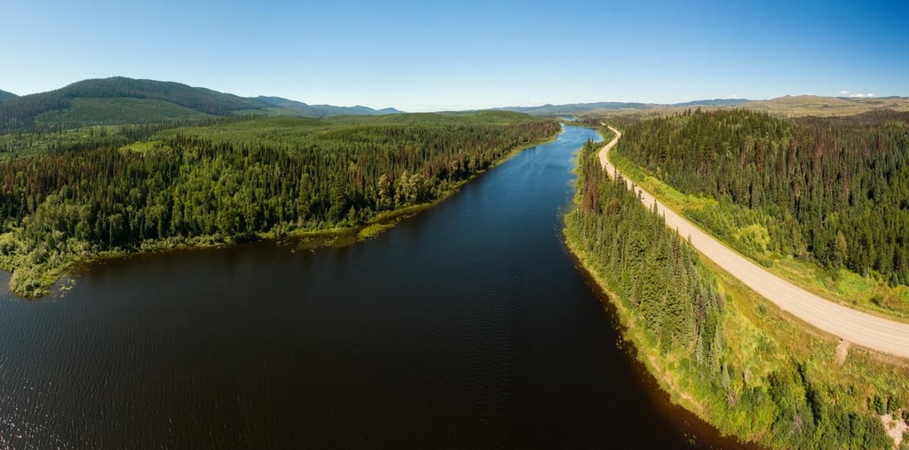
Entiako Provincial Park is a protected area located on the Nechako Plateau of central British Columbia, Canada. The relatively flat and rolling terrain of the park features the shores of Tetachuk and Natalkuz lakes as well as a portion of the Fawnie Range. Tutiai Mountain is the tallest point in the park with an elevation of 1,840 m (5,968 ft) above sea level.
Located in the interior of British Columbia, Canada, Entiako Provincial Park is a remote wilderness park that’s situated on the Nechako Plateau adjacent to the Canadian Coast Mountains.
Entiako Provincial Park encompasses 1,239 sq. km (478 sq. mi) of flat and rolling terrain around Tetachuk and Natalkuz lakes. The park rises to include some of the slopes of the Fawnie Range, which is situated along the southern end of the Nechako Plateau.
Entiako is also part of a series of parks in the region that protect some of British Columbia’s coolest natural landscapes and recreational areas. In addition to Tweedsmuir Provincial Park, other nearby parks include:
The main access to Entiako Provincial Park is from the Kluskus-Ootsa Forest Service Road. However, parts of the park (especially in the north) are typically only accessible by boat or floatplane.
Entiako Provincial Park is located in the southwest corner of the Nechako Plateau. The Nechako Plateau is the northernmost of the three major subdivisions of British Columbia’s interior plateau. The other plateau subdivisions are the Fraser Plateau and the Thompson Plateau.
The Nechako Plateau is described as having a relatively flat to gently rolling landscape that is almost completely undissected by rivers in some areas while other parts are deeply incised. The plateau surface lies between 1,200 m (4,000 ft) and 1,500 m (5,000 ft) in elevation, as the 1,500 m (5,000 ft) contour line in the region typically serves as the border between the plateau and its adjacent mountain ranges.
Most of the topography of the park was created by the Tertiary-aged lava flows that cover the older layers of volcanic and sedimentary rocks in the region. Some areas of the plateau were intruded by magma flows during the Upper Jurassic and Cretaceous periods.
The mountains of the Fawnie Range, which are found at the southern end of Entiako Provincial Park, consist of the exposed cores of these granitic intrusions. The peaks in the range are the monadnocks that formed because they were more resistant to erosion than the surrounding rock.
The entire plateau was also covered with ice during the Pleistocene, which created grooves and ridges of glacial debris. These geologic and post-glacial features have allowed geologists to know that, in general, the ice sheet flowed from the west across the plateau and toward the Rocky Mountains in the east.
The ice sheet deposited a near-universal veneer of till that obscured the bedrock across most of the plateau. Furthermore, the ice sheet’s glaciers created eskers, drumlins, kames, and meltwater channels in the region that are visible from the air to this day.
As it is located in the rain shadow of the Coast Mountains, Entiako Provincial Park has a fairly dry climate that receives relatively small amounts of precipitation in the summer and winter months. The rolling terrain in the park is dotted with the remnants of glacial lakes and is covered with a sub-boreal spruce and pine forest.
The park is important because it serves as a winter range for the Tweedsmuir-Entiako caribou population. Furthermore, the park protects winter habitats for trumpeter swans and is an important unroaded habitat for grizzly bears, wolverines, and fishers. As such, Entiako is a critical component of the region’s complete caribou/moose/wolf/bear predator-prey system.
Interspersed among the sub-boreal forest of Entiako are a number of unique ecosystems and plant communities. Some of the at-risk plant communities that exist in the region include the black cottonwood–redosier dogwood–prickly rose, bullrush marsh, and the aster–meadow rue–peavine–fireweed communities. Mount Swannell is also home to a rare occurrence of two-colored sedge.
Entiako Provincial Park is part of the traditional territory of the Ulkatcho First Nation. The area that is now part of the park has been used for generations for hunting, fishing, gathering, and the collection of medicinal plants.
Before European colonization, there were likely 1,500 members of local First Nations living around Tetachuk and Entiako lakes. Historically, there was a major village site near the Redfern Rapids. The First Nations in the region traditionally relied on fish and caribou for their food in addition to berries, the latter of which they helped to cultivate using prescribed burning.
The park contains a portion of the original Bella Coola Trail. This trail runs from Tetachuck Lake to Bella Coola and it was traditionally used for trade between the interior and coastal First Nations. The trail is part of a series of trade routes that facilitated the trade of Eulachon oil from the coast and is often referred to as a grease trail.
By the 1700s, Europeans had arrived in the region and brought with them new tools, the fur trade, and many introduced diseases.
The park has historic traplines from this period that are still used by Ulkatcho First Nation members. During the eighteenth and nineteenth centuries, the fur trade was an economic staple for many of the First Nations of the interior of British Columbia. That being said, the commercial trapping of fur-bearing animals in exchange for goods and food largely disrupted the First Nations’ traditional ways of life.
During the twentieth century, the area was also the site of several mining claims, as well as leases for cattle grazing and hay removal. In 1938, Entiako Provincial Park and Protected Area were part of Tweedsmuir Provincial Park; however, they were removed from Tweedsmuir in 1956 as the park boundary was amended to exclude all of the bodies of water that were flooded from the construction of the Kenney Dam.
The construction of the Kenney Dam in the 1950s flooded several village sites, seasonal camps, and trails, including the Bella Coola Trail. The Bella Coola Trail once ran from Aslin Creek in Entiako Provincial Park to the Ulkatcho village site, and on toward the coastal community of Bella Coola.
The major trail in Entiako Provincial Park is the Bella Coola Trail, which is a historic grease trail that connected the Ulkatcho First Nation with First Nations on the coast. The trail traditionally facilitated the trade of eulachon oil, which was used for food and in some instances for candlelight.
In the park, the trail starts roughly at the mouth of Aslin Creek and continues toward the shore of Tetachuck Lake. The trail is unmaintained and may be difficult to follow.
At the southern end of the park, the Bella Coola Trail joins the Alexander Mackenzie Heritage Trail. The Alexander Mackenzie Heritage Trail is the overland route that Mackenzie took from near modern-day Quesnel to Bella Coola. He was advised to take this overland route to finish his transcontinental crossing, which he completed on July 20, 1793.
In addition to the Bella Coola Trail, there are many other activities available in Entiako Provincial Park.
Many visitors to the park enjoy backcountry camping, canoeing, mountaineering, fishing, and hunting. There are several lodges within the park that can be booked in advance if you prefer more comfortable accommodations. Alternatively, you can camp nearly anywhere in the park unless otherwise marked.
While there are no official trails in the park, there are remnants of First Nations trading trails as well as trails created by hunting and fishing guides that visitors can follow. Keep in mind that these trails aren’t marked, so you will need good backcountry navigation skills in order to travel within Entiako Provincial Park.
Entiako Provincial Park is a remote park that’s located in the beautiful wilderness of northern British Columbia. The following are some of the closest cities to the park that you can check out during your next trip to the region.
Prince George is considered the capital of northern British Columbia. It is located on the western side of the Regional District of Fraser-Fort George, about 150 km (90 mi) to the northeast of Entiako Provincial Park.
Founded in 1807 as Fort George, the city of Prince George is situated at the confluence of the Fraser and Stuart rivers. Having had its start as a North West Company trading post that was established by Simon Fraser, Prince George has since grown into an important transportation and service hub for the northern part of British Columbia.
The city is surrounded by some of the most stunning and pristine wilderness areas in the province. Popular hikes around Prince George include the Cottonwoods Island Loop, the Greenway Trail to Shane Lake Loop, McMillan Creek Loop, Troll Lake, Kakwa Lake Trail, and Forests for the World Lookout. Additionally, the city is located near several beautiful wilderness areas, such as the Sugarbowl-Grizzly Den and Stuart River Provincial Parks.
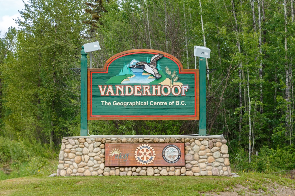
Vanderhoof is a community located on the eastern side of the Regional District of Bulkley-Nechako. It is surrounded by seemingly endless miles of wilderness and is located about 120 km (72 mi) to the north of Entiako Provincial Park. The small town is rich with ancient history as it was an important location among the European settlers of what is now British Columbia.
Located several miles to the west of Vanderhoof are the remains of a First Nations village called Chinlac. Simon Fraser made note of the village in his diary that, in 1806, he was likely the first European to trade with the community.
While the area is rich in history and culture, there are also incredible wilderness areas and trails that are worth hiking around Vanderhoof. Some of the main attractions in the area include a walking tour of Vanderhoof, the Chinlac Village Site, Gluten Lake, and the Vanderhoof Bird Sanctuary. There are also many trails to check out in and around Vanderhoof, such as the Telegraph Trail, Home Lake Trail, and Johnson Lake Trail.