
Scan the QR code and open PeakVisor on your phone
Hart Mountain National Antelope Refuge has 11 named peaks. The highest is Warner Peak at 2,442 m. Other notable peaks include High Point, Hart Mountain and Adams Butte.
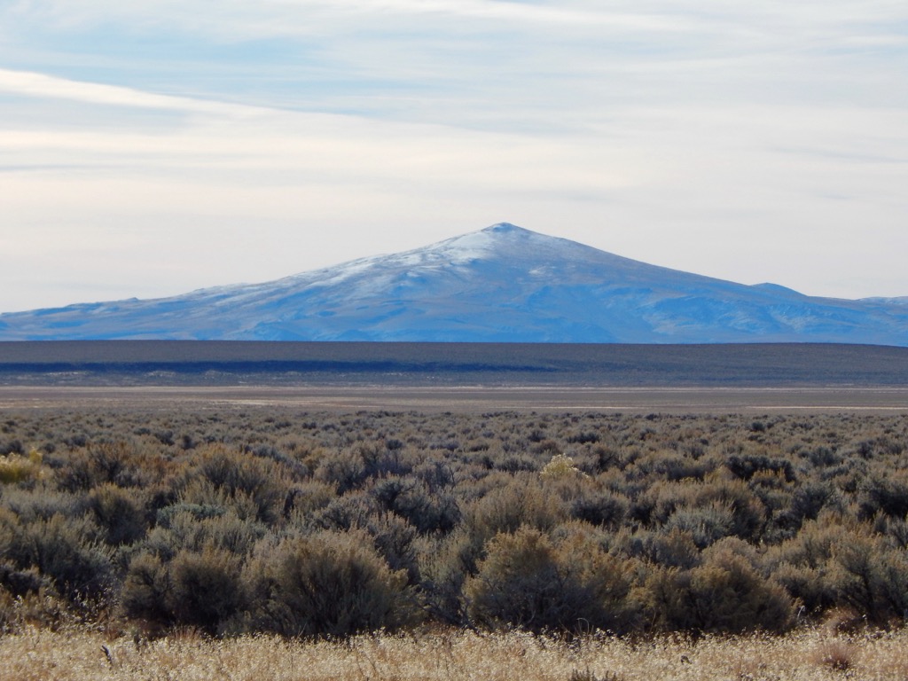
The Hart Mountain National Antelope Refuge is located in the southeastern portion of the US state of Oregon. The high desert and mountainous landscape marks one of the largest refuges in the US that does not contain domestic livestock. The tallest and most prominent mountain is Warner Peak at 8,012 feet (2,442 m) tall with 2,126 feet (648 m) of prominence.
The Hart Mountain National Antelope Refuge lies in southeastern Oregon, close to the state’s border with both California and Nevada. The entire refuge lies within Lake County and spans 270,608 acres (109,511 ha).
This refuge features a diverse landscape, all situated around Hart Mountain, a fault block mountain. Elevations rise steeply from the floor of Warner Valley up to the rugged ridgelines of Hart Mountain.
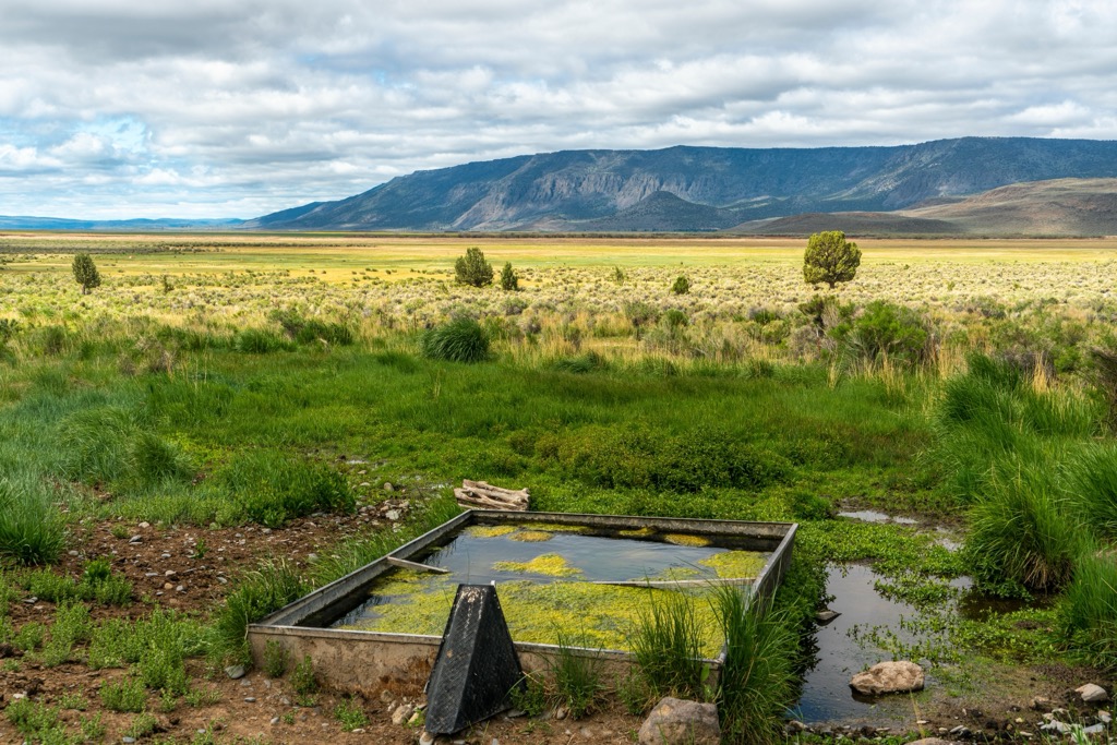
Terrain is marked by high desert, craggy peaks, and shallow playa lakes. Numerous lakes lie along the western edge of the refuge, providing freshwater for the variety of wildlife that inhabit the region. Some of the major lakes include Crump, Hart, Swamp, and Upper Campbell Lake, which help makeup the Warner Valley Wetlands
The west side of Hart Mountain is marked by deep gorges, with Hart, Potter, and Degarmo canyons spanning from the valley floor up to the top of the ridgeline. Elevation changes are less dramatic along the eastern edge of Hart Mountain, marked by rolling hills and ridges.
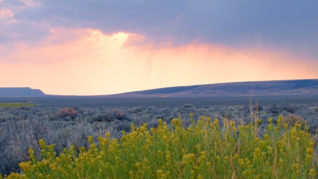
A majority of the landscape is marked by sagebrush-grasslands, with the high desert terrain making it difficult for large forested patches to thrive. Hikers are likely to spot low growing shrubs and grasses, while the west side of Hart Mountain is relatively free of flora.
Additionally, the Hart Mountain National Antelope Refuge is surrounded by various areas for outdoor recreation. The Orejana Canyon Wilderness Study Area lies to the north while a portion of Fremont-Winema National Forest is to the southwest. The Sheldon National Wildlife Refuge is located to the south in Nevada while the Basque Hills and Rincon Wilderness Study Areas lie to the southeast.
The ridgelines and named peaks within the refuge are all part of Hart Mountain. The mountain is often mistakenly referred to as a mountain range and is part of the Great Basin Ranges, also known as the Basin and Range Province. This region spans across the western US into the states of California, Oregon, Idaho, Nevada, and Utah.
Hart Mountain is a block fault mountain that began forming during the Early Miocene. During this time the surrounding region experienced widespread extension and lava flows, giving way to the surrounding ranges and high desert terrain.
The stretching of the Earth’s crust resulted in the series of alternating peaks and valleys which give the region its name. Hart Mountain was continually thrust upwards while the nearby valley slowly dropped in elevation.
Similar to other mountains and ranges in the region, elevation changes are far more dramatic along the west side of Hart Mountain while the east side features more gradual slopes. Though volcanic rock can be found in the area, Hart Mountain is not part of the volcanoes in the Cascade Range which lies to the west.
Major peaks within the refuge include Warner Peak, Poker Jim Ridge, Hart Mountain, and Adams Butte.
A majority of the refuge is populated by sagebrush-grasslands and low growing shrubs. The steepest elevations are often free of flora while the valley floor is characterized by wetlands. Flora found here is similar to that found in the high desert of eastern Oregon.
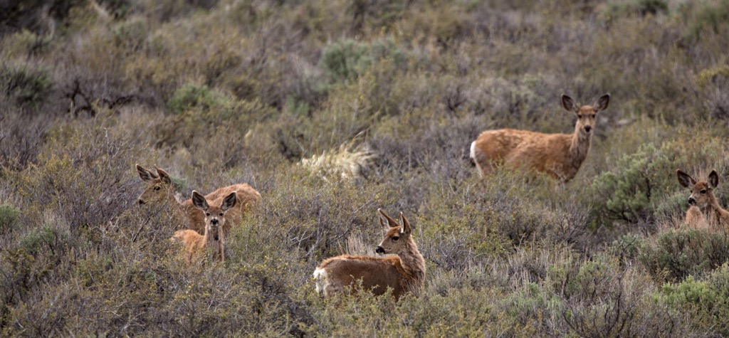
True to its name, the refuge helps support a population of pronghorn antelope. Other large animals that inhabit the refuge include mule deer, bighorn sheep, coyotes, and occasionally cougars.
Over 300 animal species live in the region including sage grouse, American pika, burrowing owl, and pygmy rabbit. The various streams and surrounding wetlands provide an ideal habitat for redband trout and various waterfowl.
Human history surrounding the Hart Mountain National Antelope Refuge dates back thousands of years. Long before the arrival of Europeans, this region marked part of the ancestral lands of numerous Indigenous peoples.
Some of the most prominent groups in the region included the Northern Paiute and Cayuse, Umatilla, and Walla Walla. This land marked some of the southernmost stretches of the Cayuse, Umatilla, and Walla Walla Tribes.
This terrain marks some of the western stretches of the Northern Paiute traditional territory. These peoples primarily lived in present day eastern Oregon and northwestern Nevada.
Descendants of these Tribes are now part of the Confederated Tribes of the Umatilla Indian Reservation, Pyramid Lake Paiute Tribe, Burns Paiute Tribe, Confederated Tribes of Warm Spring, and Fallon Paiute Shoshone Tribe.
The first recorded contact between Europeans and the Indigenous peoples of the region was in 1846. During this time, an expedition was led by Charles Fremont through northern Nevada and California into eastern Oregon. The California Gold Rush in 1848 brought more people to the surrounding region.
Small communities of settlers began to grow in the area, leading to conflict between the two groups. These conflicts ultimately led to the Modoc Indian War which lasted from 1872 to 1873 near the border between Oregon and California.
Kintpuash, the Modoc leader, led his people from their reservation in Oregon back to their native homelands in California. Roughly 600 US soldiers were deployed to confront the 60 Modoc fighters. Following six months of battle, the Modoc surrendered and their tribal leader was executed by US forces.
The remaining tribal members were forcibly removed from their native homelands and placed onto reservations. Native American boarding schools took Indigenous children from their families and forced them to assimilate to western customs and culture, in an attempt to eradicate their traditional ways of life.
The Hart Mountain National Antelope Refuge was created in 1936 to help protect the animals in the region. Today, the refuge helps protect all wildlife and native plants in the region.
The Hart Mountain National Antelope Refuge features a few hiking trails that help highlight the natural landscape of the region. Here are some of the top hiking areas to visit in the area:
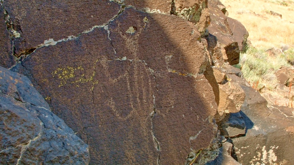
This hiking route lies near the center of the refuge. The trail begins relatively flat, winding through the grasslands before reaching Petroglyph Lake. This seasonal lake is surrounded by jagged rock formations, some of which feature petroglyphs.
The route then leads around the lake and climbs steadily up to Poker Jim Rim. From the top, hikers can look at the expansive flat lands to the east or the dramatic cliffs and wetlands extending to the west. This out and back trail is 6.1 miles (9.8 km) long and features 387 feet (118 m) of elevation gain.
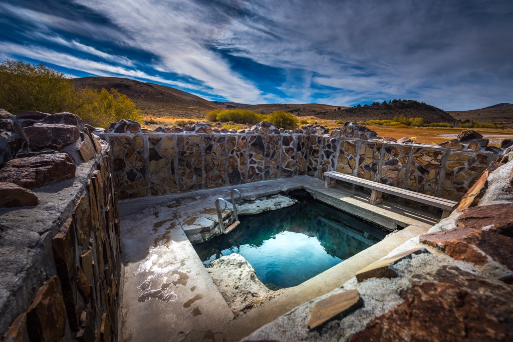
This loop trail lies near the center of the refuge, surrounded by the rolling grasslands and foothills. The short loop takes hikers past various creeks and streams while featuring both a developed hot spring and an undeveloped hot spring.
Those visiting can stay at the Hart Mountain Hot Springs Campground and experience some of the best stargazing in the state. This loop trail is 0.8 miles (1.3 km) long and features 52 feet (19 m) of elevation gain.
Warner Peak marks the tallest and most prominent named mountain within the refuge. The route to the summit begins by following a well-maintained service road which climbs steadily throughout. During the warmer months, the sagebrush-grasslands are interspersed with various wildflowers.
The final 0.75 miles (1.2 km) of the route involves a scramble as there is no defined path. Lack of tree coverage makes navigating to the summit easy, while hikers pass over low growing grasses. This out and back route is 10 miles (16 km) long and features 2,483 feet (759 m) of elevation gain.
Looking for a place to stay near the Hart Mountain National Antelope Refuge? Here are some of the best cities and villages to check out in the region:
Lakeview lies just southeast of the refuge, marking the closest town to the protected region. Known as the “Tallest Town in Oregon”, Lakeview sits at an elevation of 4,802 feet (1,464 m). Home to 2,400 residents, the small town is situated in the Goose Lake Valley, at the foothills of the Warner Mountains.
The Outback Scenic Byway passes through the region, while the town lies along the edge of Oregon’s high desert region. Besides exploring the refuge, Lakeview acts as a great base for visiting Drake Peak Lookout, Goose Lake State Recreation Area, and the sand dunes of Christmas Valley
The city of Klamath Falls, Oregon lies a two hours drive west of Lakeview, marking the closest city to the refuge. With a population of 20,000 residents, the city lies along the southeastern shores of the Upper Klamath Lake.
Klamath Falls lies on a known geothermal resource area and has been using geothermal power since the early twentieth century. Those visiting can explore nearby Crater Lake National Park and Lava Beds National Monument, while opportunities for trail running, mountain biking, hiking, and kayaking all lie within the city limits.
The downtown streets feature local shops, cafes, restaurants and breweries. Klamath Falls is surrounded by the beauty of the high desert to the east and the Cascade Range to the west.


The highest peak in Hart Mountain National Antelope Refuge is Warner Peak, at 2,442 m.
Notable peaks in Hart Mountain National Antelope Refuge include Warner Peak, High Point, Hart Mountain, Adams Butte and Poker Jim Ridge.


