
Scan the QR code and open PeakVisor on your phone
Located along the western edge of the Columbia Mountains of eastern British Columbia, Canada, Graystokes Provincial Park is a protected area that encompasses parts of the Beaverdell Ranges and the Okanagan Highland. The park has 3 named peaks, the tallest of which is Mount Moore at 2,267 m (7,110 ft) in elevation. The peaks in the park overlook a complex ecosystem of swamps, meandering streams, meadows, old-growth subalpine forests, and the Graystokes Plateau.
Graystokes Provincial Park is located in eastern British Columbia, Canada. It is situated on the eastern side of the Interior Plateau along the western edge of the Columbia Mountains. The park encompasses part of the Okanagan Highland as well as the northern end of the Beaverdell Range.
Located to the east of the popular Okanagan city of Kelowna, Graystokes Provincial Park is one of many parks in the region that have been created for conservation and recreational purposes. Some of the many other parks that are located nearby include:
The largest portion of Graystokes Provincial Park is situated in the Okanagan Highlands of central British Columbia. The Okanagan Highlands are the most southerly of the three highland subdivisions of the province alongside the Shuswap Highlands and the Quesnel Highlands.
The Okanagan Highlands extend from southern British Columbia to the state of Washington in the US. To the east of the Okanagan Highlands, you can find the Monashee Mountains, which are a major subrange of the Columbia Mountains. The Thompson Plateau lies to the west of the Okanagan Highlands.
The geology of Graystokes Provincial Park is characteristic of the geology of the Okanagan Highlands. The mountains and ridges of the park are rounded over and are typically less than 2,200 m (7,000 ft) tall. Mount Moore and Jubilee Mountain are the tallest mountains in the park and they are among the tallest peaks in the Okanagan Highlands.
Much of the highlands in the park are underlain by the Shuswap gneisses, which, through their differential erosion, have created gentle steppe-like slopes and plateaus, such as the Graystokes Plateau. Furthermore, the highlands are dissected by the Okanagan and Kettle rivers and their tributaries.
An ice sheet covered the bulk of the highlands during the Pleistocene; however, the erosion caused by the ice sheet is not as prominent in the highlands as it is in other nearby mountainous locations. That said, the ice sheet did slightly round over the ridges and peaks in the highlands, and it deposited a widespread mantle of drift across the region.
At the end of the Pleistocene, meltwater cut further into the highlands, and marginal glacial lakes started to form where silt was deposited. The silt deposits from the glacial lakes now exist as white cliffs along the valley edges. These cliffs are especially prominent along the southern edge of Okanagan Lake.
Graystokes Provincial Park is one of the main areas where you’ll find the North Okanagan Highlands Ecosection. In fact, it contains nearly a third of the province's representation of this ecosection. The major habitats in the park are described as the Interior Mountain-Heather Alpine and the Engelmann Spruce – Subalpine Fir ecosystems.
Comprising about 20 percent of the park, the Interior Mountain-Heather Alpine can be found in the highest elevations of the region. The alpine zone of the park features the rocky summit peaks of Mount Moore and Jubilee Mountain as well as the heather and grass-filled alpine meadows that are typically found above the treeline. Subalpine fir is the dominant tree species along the treeline in the park, and it is the main species that forms krummholz trees in the region.
Within the park, the alpine transitions to the subalpine forests, which are dominated by Engelmann spruce. Engelmann spruce tend to live longer than subalpine fir, and, as a result, spruce dominate the lower elevation forest canopies in the park. However, subalpine fir is more tolerant to the cold, so it grows at higher elevations in the mountains within Graystokes Provincial Park.
Graystokes Provincial Park contains undisturbed old-growth forests of Engelmann spruce, subalpine fir, and Douglas fir. The forests provide important habitat for grizzly bears who also have their range in Granby Provincial Park, which is located to the southeast of Graystokes Provincial Park.
The forests and meadows of Graystokes Provincial Park also provide the ideal habitat for other animals that typically reside in the spruce and fir forests, such as moose, mule deer, white-tailed deer, marten, and fisher.
The temperatures in the Okanagan are known to be among the hottest in Canada. As a result, the highlands of Graystokes Provincial Park provide important food sources for ungulates when the lower elevations become too hot and dry for local wildlife.
Furthermore, among the swamps, bogs, streams, and meadows in the park, there are many lakes full of fish. The park has ten lakes full of rainbow trout, all of which support natural populations.
The land in and around Graystokes Provincial Park is part of the traditional territory of the Sinixt and Syilx First Nations.
While there is currently no inventory of cultural sites in the protected area, the plateaus, wetlands, meadows, streams, and rivers were all likely used for hunting and gathering for generations before European contact. Furthermore, the Sinixt traditionally had a practice of sending children on spiritual journeys, which may have taken place in the area that is now Graystokes Provincial Park.
Both the Sinixt and Syilx (Okanagan) are part of the Interior Salish ethnological and linguistic groups. The Syilx were traditionally hunter-gatherers who moved from place to place while following the hunting and gathering seasons of the region. Meanwhile, the Sinixt were considered “complex collectors.”
The difference between a “complex collector” culture like what was historically practiced by the Sinixt and a hunter-gatherer culture like what was historically practiced by the Syilx has to do with the mobility of a community.
The Syilx would regularly move camps according to the seasons and they would stay short-term in many different locations. The Sinixt were more sedentary than the Syilx and would remain closer to their mountain and lake-dominated homeland throughout the seasons. However, both First Nations would typically winter in semi-permanent homes, which were often pit houses or semi-subterranean structures.
While the Sinixt did participate occasionally in the fur trade, the Syilx were especially active in the trade. In fact, many Syilx were the main traders at various trading posts, and they were keen on maintaining their territory and local advantages.
However, before the arrival of the Scottish and Métis fur traders in the late eighteenth century, smallpox epidemics heavily depopulated the nations. In fact, the 1781 smallpox epidemic is suspected to have had an 80 percent mortality rate among the First Nations in the region.
The park was created in 2001 to protect the unique ecologies that are found in the Okanagan Highlands. The park is a popular place for hunting, fishing, and snowmobiling. A local club has created nearly 300 km (180 mi) of trails that cross the park, including paths to the popular Graystokes Plateau.
Graystokes Provincial Park is considered to be a relatively remote area; however, there are several access points to the park via a collection of main logging roads.
Due to the marshes and bogs that are found throughout the park, some seasons are more enjoyable for hiking and recreation than others. That said, there are year-round activities available in the park for visitors to enjoy.
Here are some of the best outdoor activities in Graystokes Provincial Park to consider before your next trip to the region.
While there are no official trails in the park, there are informal routes to many of the park’s lakes as well as the summits of Jubilee Mountain and Mount Moore. There are no facilities in the park; however, hikers are welcome to camp among the lush meadows that dominate the region or wherever suits their fancy.
Due to the remote nature of the region, visitors to Graystokes should be comfortable with backcountry navigation and wilderness safety before setting out on their adventure.
During the winter months, the most popular activity in Graystokes Provincial Park is snowmobiling. A local club has created nearly 300 km (180 mi) of trails that wind through the park and adjacent wilderness areas.
The most popular snowmobile trails in the park are groomed for the season and there is signage directing users to the region’s main destinations. The Graystokes Plateau is likely the best area for snowmobiling in the park.
Cross-country skiing and snowshoeing are the other winter activities that visitors can enjoy in Graystokes. However, there are no formal trails for skiing or snowshoeing in the park, and the region’s popularity for snowmobiling may limit the appeal of these activities in certain areas.
Graystokes Provincial Park is home to ten lakes that have natural populations of rainbow trout. Getting to the lakes requires some off-trail travel as there are no official trails that lead to these bodies of water.
Nevertheless, if you’re willing to put in a bit of effort, a trip to the remote and pristine lakes of the park can make for an excellent fishing adventure.
Looking for a place to stay near Graystokes Provincial Park? Here are some of the best cities and towns to check out in the region.
Kelowna, British Columbia is built upon the shores of Okanagan Lake in the Regional District of Central Okanagan. Kelowna is one of the province’s major metropolitan areas. It offers good access to the many attractions and wilderness areas of the Okanagan Highlands and the surrounding areas.
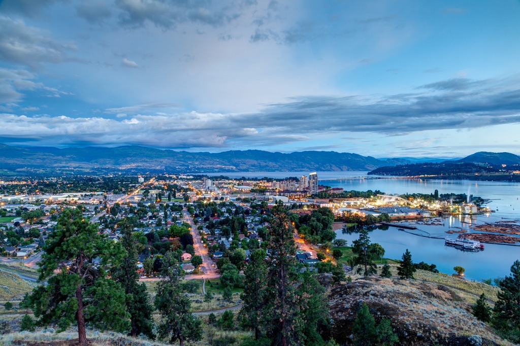
There are many lakeside accommodation options to choose from in the city, as well as campgrounds and hotels. Golf courses, fantastic restaurants, orchards, and farmer's markets are abundant within this popular resort city. There are innumerable hiking opportunities around the city, too, many of which lead along the lake, down a ridge, or up a stream to a waterfall.
Graystokes Provincial Park is located about 60 km (36 mi) to the east of Kelowna, and there are many more wilderness parks and hiking areas situated near the city to check out during your travels. For example, Myra-Bellevue Provincial Park, Okanagan Mountain Provincial Park, Dark Lake Provincial Park, and Eneas Lake Provincial Park are several of the main hiking areas located near Kelowna that are worth visiting if you’re in the area.
The city of Vernon is situated at the north end of Okanagan Lake and Kalamalka Lake. Vernon is the largest city in the North Okanagan, and it is surrounded by beautiful orchards and highlands wilderness.
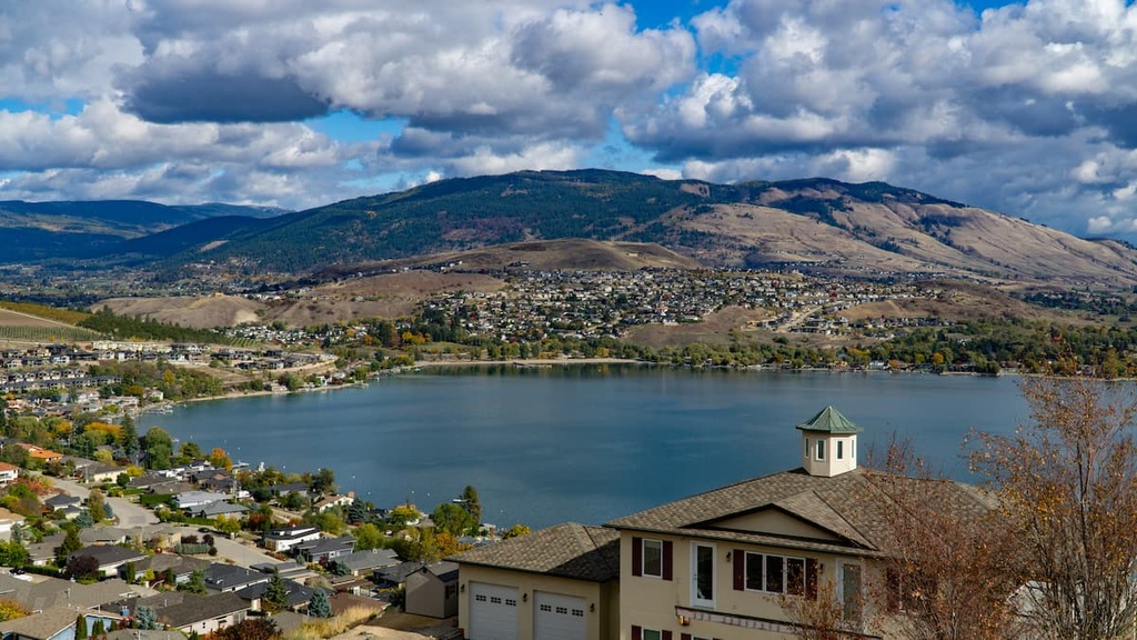
Set among rolling hills that are home to ranches, farmland, vineyards, and orchards, the city of Vernon is a true oasis on the shores of Okanagan Lake. Vernon is a little smaller and a little more relaxed than the nearby city of Kelowna; however, it has all the amenities you need for an enjoyable trip.
There are many companies in Vernon that offer guided and self-guided tours of nearby vineyards. Additionally, Vernon hosts a series of farmer’s markets that you can stroll through on the weekend when you’re not on the water or in the hills.
Graystokes Provincial Park is located about 100 km (60 mi) to the northwest of Vernon. Some of the other hiking areas located near Vernon that are worth visiting include Kalamalka Lake Provincial Park, Ellison Provincial Park, and Truman Dagnus Locheed Provincial Park.


