Scan the QR code and open PeakVisor on your phone
Granby Provincial Park is a protected area located in southern British Columbia, Canada. It consists of the Upper Granby River drainage, which spans the Regional Districts of North Okanagan and Central Kootenay. The park has 11 named mountains, of which Mount Tanner is the tallest and the most prominent with 2,414 m (7,920 ft) of elevation and 1,178 m (3,865 ft) of prominence.
Encompassing the bulk of the Upper Granby River drainage, Granby Provincial Park is unique among the southern interior parks of British Columbia in that it contains a complete and intact watershed. The park is protected from logging activities and covers over 408 square kilometers (157 square miles) of alpine peaks, meadows, and old-growth forests.
The valleys in the park are ideal for hiking and fishing while the higher elevations provide opportunities for year-round recreation. The tallest and most prominent peak in the park is Mount Tanner, with 2,414 m (7,920 ft) of elevation and 1,178 m (3,865 ft) of prominence. Trails in the park lead up and over Lightning Peak, Mount Sloan, Mount Young, and Bluejoint Mountain.
Granby Provincial Park is located within the regional districts of North Okanagan and Kootenay Boundary. The closest highway to the park is Highway 6, from which the gravel surfaced Mount Scaia Road leads into the park. The southern part of the park is accessible via the Bluejoint Lookout Trail from the end of the North Fork Road.
British Columbia has over 800 provincial parks and protected areas, including Granby Provincial Park. The following are some of the other parks located near Granby that are worth checking out:
Granby Provincial Park is situated between the Midway Range and the Christina Range, both of which are part of the Monashee Mountains. The Monashee Mountains are the southwestern ranges of the Columbia Mountains in British Columbia.
The Monashee Mountains are a mix of different rock types; however, the most common rocks in the range are late Paleozoic and Mesozoic sedimentary and volcanic rocks. There are also large masses of granites that formed during the Cretaceous
The formation of the Monashee Mountains started around 160 million years ago during a formation event called the Sevier orogeny. The Sevier orogeny when tectonic plates under the Pacific collided with the west coast of North America and began to slide beneath the continent in a process known as subduction.
As the tectonic plates subducted beneath the continent, volcanic island arcs and microcontinents rafted into the west coast and accreted to the continental margin. These exotic terranes account for most of the current landmass of British Columbia.
As new terranes accreted to the west coast, the collision compressed the crust, causing the temperature of the layers of rock to increase to the point where the rock is malleable enough to be folded. The layers of rock were compressed, folded, and eventually lifted above sea level and thrust into the sky to form the Columbia Mountains.
The compression and folding of the rock layers also created thin and weak areas in the crust through which magma could flow. During the Cretaceous, magma flowed through the crust and cooled between layers of sedimentary rocks, creating batholiths and other granitic formations in the mountains.
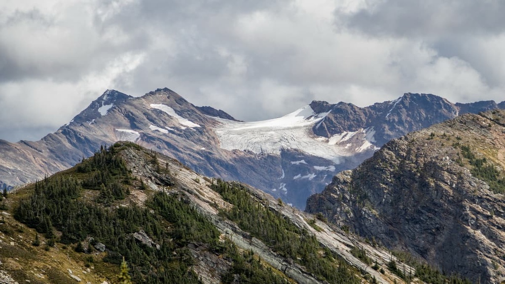
During the Pleistocene, peaks above 2,440 m (8,000 ft) towered above the Cordilleran ice sheet but were subjected to cirque glaciation.
However, all the peaks in Granby Provincial Park were generally covered by the ice sheet, so they are much more rounded in appearance. Peaks below 2,140 m (7,000 ft) were particularly subjected to the scouring action of the ice sheet so only rounded or moderately pointed summits remain.
The north-south trending valleys of the Monashee Mountains were heavily glaciated during the Pleistocene. The ice started to retreat from the ranges about 15,000 years ago. For about 5,000 years, a deep layer of glacial drift was deposited in the valley bottoms.
Granby Provincial Park is special because it contains the only fully intact watershed in the southern interior of British Columbia. A fully intact watershed refers to the fact that no logging has occurred in the catchment area of the Upper Granby River basin and all the forests are old growth forests that have been left in their natural state.
Old growth forests provide important and irreplaceable habitat for many wildlife species. The park has forests of ancient hemlock and cedar. It protects some of the most important grizzly bear habitat in the southern Monashee Mountains. Additionally, the steep valley is inhabited by mountain goats.
The alpine areas of the park are typically covered in grasses, sedges, and heather. The Dragon Flats area is a grassland meadow. It has a unique ecosystem and it is also home to the endangered nettle-leaved giant hyssop.
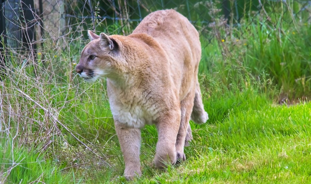
The rolling meadows and terrain between the Midway and Christina Ranges from the alpine to the subalpine are home to many more animal species, including cougars, lynx, and bobcats. Deer are the main ungulate found in the park; however, moose, elk, or caribou may make an appearance, too, and both wolverines and martens are also found in the park.
The area around Granby Provincial Park is part of the traditional territory of several First Nations. The park and surrounding region has been traditionally used by the Ktunaxa, Sinixt, and Sylix First Nations for hunting, gathering, and other cultural purposes.
Archeological sites within the park include culturally modified trees, remnants of a heritage trail, and a possible First Nations hunting camp. The most common evidence of culturally modified trees in British Columbia is the removal of strips of outer and inner bark from western red cedar trees for use in baskets and other items.
The Granby River Trail has evidence of First Nations use; however, most of the trails through the park were heavily used by miners and settlers during the nineteenth and twentieth centuries. The trail from Lightning Peak to Edgewood is called the Rawhide Trail. It was used to transport ore from the mines in the northwest corner of the park.
Additional post-contact history includes the Height of the Land Trail that was a stagecoach and mail delivery route. However, except for the minor mining activity and the mail route, the landscape and the forests of Granby Provincial Park have been left largely untouched by resource extraction industries.
Much of the appeal of Granby Provincial Park is the fact that it is an undeveloped wilderness park with no roads and no facilities. While there are no official trails in the park, there are several historic routes that are popular for hikers and backpackers.
The following are some of the popular hikes in Granby Provincial Park:
Looking for a place to stay near Granby Provincial Park? Here are some of the top cities and towns to check out in the area:
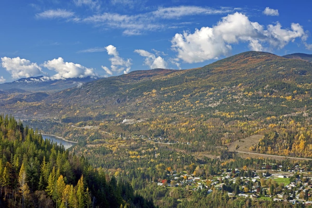
Incorporated as a city in 1901, the city of Trail was named after the Dewdney Trail that once passed through the area. Trail is located about 280 km (168 mi) from Granby Provincial Park, and it has many attractions and hikes for visitors to enjoy. This includes Beaver Creek Provincial Park, the Columbia River Skywalk, and many museums and art galleries.
Some of the popular trails around the city include the Columbia River Trail, the Rusty Chainsaw Loop, Sunningdale Trail, and Miral Heights and Bluffs Trail. A couple other trails that are worth checking out include the Elder Trail, and the Raven Cliff to McQuarrie Creek Trail.
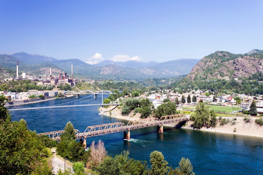
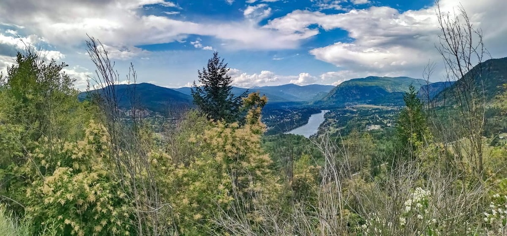
Castlegar is a community in Central Kootenay. It is located about 180 km (108 mi) from Granby Provincial Park. The city is situated in the Selkirk Mountains at the confluence of the Kootenay and Columbia Rivers.
Castlegar started as a settlement for miners as they searched for gold. The city now has a rich history in the mining and forestry activities of the nineteenth and twentieth centuries. The area is also culturally significant to the Sinixt and Ktunaxa First Nations.
Some of the major attractions in Castlegar, aside from its access to incredible wilderness areas, are the Doukhobor Discovery Centre, Kootenay Gallery, and Zuckerberg Island Park. Some of the recommended hiking trails in the regions include the hikes to the Brilliant Overlook, McPhee Waterfalls, Dove Hill, and the Zuckerberg Island Loop.
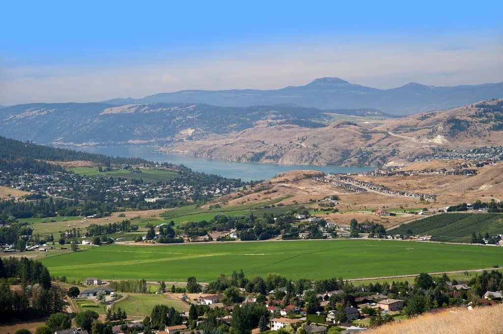
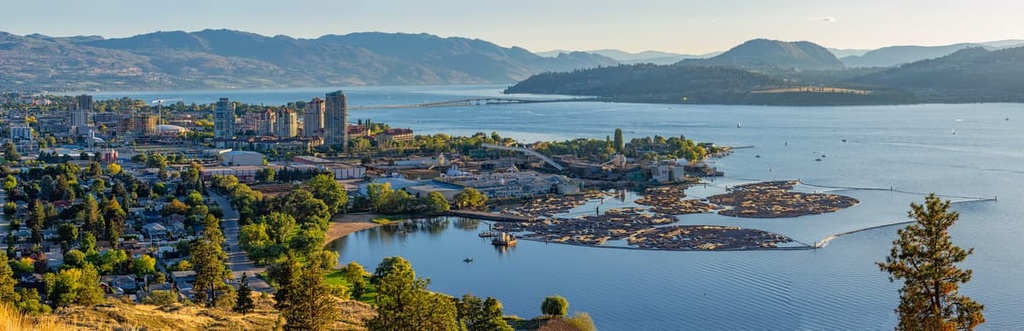
The city of Kelowna, British Columbia is located to the northwest of Granby Provincial Park. It spans both shores of Okanagan Lake. There are many lakeside accommodations, campgrounds, and hotels to stay at while visiting the region.
Kelowna is a popular destination with its proximity to Okanagan Lake, sandy beaches, countless orchards, warm weather, and a relaxed atmosphere. There are fantastic restaurants in the city that are run by local First Nations, as well as scenic golf courses, farmers markets, and an unusually large number of restored antique and vintage cars driving around the city.
With hot summer weather and mild winters, there are year-round outdoor adventures to be had in Kelowna. Along with the fun water-based activities on the lake, there are countless trails that take you along the lake, through the hills, along ridges, and up to the tops of the many peaks in the area.
The city of Vernon is located at the north end of Okanagan Lake and Kalamalka Lake. Vernon is one of the closest cities to Granby Provincial Park and it is the largest city in the North Okanagan.
Vernon is a little smaller and a little more relaxed than the nearby city of Kelowna. However, it has all the amenities to make your stay enjoyable without the crowds that sometimes exist at popular locations in Kelowna.
The city is surrounded by rolling hills that contain ranches, farma, vineyards, and orchards. There are guided and self-guided tours of the region’s vineyards, as well as farmer’s markets to stroll through on the weekends when you’re not on the water or in the hills.