
Asia might have more mountains on its banknotes, but all the rest of the world also has some intricate offers. Even though the highest mountain of the European continent has failed to make it to any national currency tokens, its counterparts in South America and Africa made up for it. Here is the list of mountains, tall and not very tall, which you can see on the money now or might have seen 20-30 years back.
Europe
With the introduction of euro and ensuing unification of the banknotes, only Switzerland can boast of a unique design and some mountains currently present on its money.
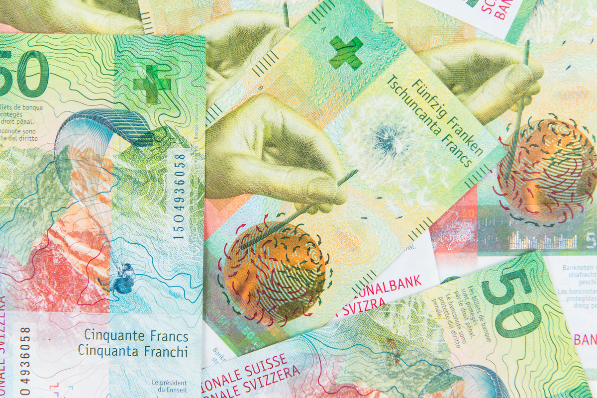
The Alps: Switzerland (Swiss Francs)
Thinking of this land flowing with milk and honey, rich in ultra mountains, rainbows and sunshine, you might automatically assume some of its majestic telltale peaks have made it to the banknotes. Well, you’d better reconsider the assumptions. Take the perfect pyramid of Matterhorn (4,478m) for example, doesn’t it deserve to feature on the country’s money as its Himalayan sister Ama Dablam (6,814m)? Either the peak is too majestic, or the money is too mundane to live up to the standard of this perfectly shaped tetrahedron. Matterhorn is a Toblerone symbol, after all, what is better than money? Swiss chocolate!
Switzerland can boast of so many gorgeous summits that it probably did not want to offend any. Thus, you will see the Alps and lists the names of the main four-thousand-metre peaks in the Swiss Alps, from A for Aletschhorn to Z for Zumsteinspitze on the security strip of a 50-franc note.
Les Diablerets, Switzerland

Les Diablerets is a village and ski resort located in the municipality of Ormont-Dessus in the canton of Vaud, Switzerland. It is surrounded by the Diablerets Massif, its peak (Sommet des Diablerets at 3,210 metres (10,530 ft)) is the highest point in western Switzerland. You can access the spot by train or by car from Aigle. Also, while in the area, don’t be shy to use the Glacier 3000 cable car and go to the notorious Scex Rouge (2,971m).
If you have itchy feet, a trip to Mt. Scex Rouge will allow you to see the wonders of almost 2000 meter high amphitheatre of cliffs surrounding the Creux de Champ valley, south of Les Diablerets. In the summertime, the mountain is open to hiking with trails across the glacier between Scex Rouge, Quille du Diable and the Oldensattel, at the foot of Odlenhorn. The mountain itself is for experienced hikers only can be reached from Reusch via Oldensattel or from Derborece and the Sanetshc Pass via the Quille du Diable, or from Les Diablerets via the Col de Prapio and the Col du Pillon. In winter (October to May), this is the place for good skiing.
Mt. Scex Rouge offers a perfect view of its parent peak, Diablerets, a huge ice-capped mountain at the western end of the Bernese Alps. On the southeast side, Scex Rouge overlooks the Transfleuron Glacier, the largest in the massif.
There are two aerial tramways operated by Glacier 3000 leading to Scex Rouge, one connects it to the Col du Pillon (Vaud canton) and then leads to the summit of the Tete aux Chamois (2,525m). The other takes off from Tête aux Chamois, a second aerial tramway leads to near the summit of the Scex Rouge, or more precisely, a 2,965 metre-high subsidiary summit. The mountain station lies at an elevation of 2,940 metres and consists of a large building, designed by Mario Botta, including a panoramic restaurant.
And the icing on your cake is certainly the 107 metre-long suspension bridge, called Peak Walk, which was inaugurated in October 2014. There is a long read on suspension bridges in the Swiss Alps, worth having a peek at.
Mont Blanc, alas, never made it
Mont Blanc technically belongs to France, what does it have to do with Switzerland you would ask? It almost made it to the country’s money in 1997. The bancnote of 20 francs is with Mont Blanc andh view of the valley of Chamonix and the Mont Blanc massif, showing expedition to the Tacul glacier. The story is really sad.
The highest, the coldest, the deadliest in Europe, there is nothing average about Mont Blanc (4,810 as of 2011), all the laudations seem to run in superlatives probably to live up to the flawless name of the 'monarch of the mountains'. With the stats attached, you cannot but admire this white glittering peak and people who endeavour to conquer it, regardless of the high fatality rate. The Death has been reaping about 100 climbers every year since the first recorded climb in 1786. Yet, Mont Blanc is not that dark and dreary, it has a fun sense of humour as well, you can read more about its stats and issues here.
Speaking of Mont Blanc’s humour, it was meant to appear on a 20-franc note designed by Roger and Elisabeth Pfund for the seventh series of Swiss banknotes in 1984. Those designers were a bit unlucky with landing a contract with the Swiss mint. They had originally won the competition for the design of the sixth series, but since the Swiss National Bank decided to use the design by Ernst and Ursula Hiestand instead, the Pfunds were charged with the design of the reserve series.
This seventh series was actually produced in parallel with the sixth series but was never released. It formed the reserve series, to be released, for example, if the current series would suddenly become widely counterfeited. At first, almost no information was released on the series for security reasons, except for small fragments. However, after the eighth series was released, it was decided to improve the security features of the current series rather than develop a new reserve series. The details of the seventh series were later released, while the actual banknotes were destroyed.
Africa
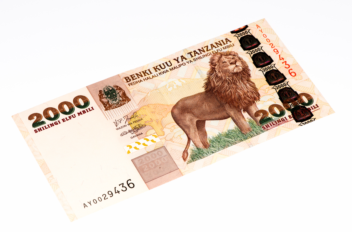
The African continent has 75 mountains with a prominence of at least 500m, there are 31 four-thousanders, but only one actually made it to the money series. After a lot of squinting and peering at African currencies, here is the hero: the dormant stratovolcano of Mt. Kilimanjaro(5,895m a.s.l). Even though Mt. Kenya (5,199m) is the second highest on the continent, it has not made it to the Kenyan shilling banknotes.
Mt. Kilimanjaro, Tanzania (Shilling)
Mt. Kilimanjaro, Africa’s highest mountain, stands tall as Tanzania’s most prominent landmark, dominating the vast plains of the country. It is located on Tanzania’s northern border, overlooking Kenya, and is over 322 kilometers (200 miles) from the equator. With snow-capped peak and forested surroundings, it is one of the world’s highest free-standing mountains. It has three peaks, named Kibo, Mawenzi (5,149m) and Shira (4,005m), of which Kibo is the tallest.
The ideal time to visit Mt. Kilimanjaro is during its main trekking season, that is, from January to mid-March and June to October. November and December are best avoided, due to heavy rains and thick cloud cover on the higher reaches.
Ascending 5,895 meters to summit Mt. Kilimanjaro may seem intimidating, but surprisingly climbing it does not require any mountaineering skills or specialized equipment. What it basically requires is top physical condition and strong will power. People as young as seven and as old as 84 have done it. There is a legend made popular by a retired Tanzanian army general, Mirisho Sarakikya, is that climbing Mt. Kilimanjaro is a measure of one’s health. Only those with a healthy body will manage to reach the summit and those with health problems will not. The general himself has summited this ‘rooftop of Africa’ an impressive 38 times. One can only imagine how health-problem-free would Richard Byerley be when he succeeded in summiting the peak at the ripe old age of 84! He figures in the Guinness World Records as the oldest person to do so!
The Kilimanjaro National Park (KINAPA) is responsible for controlling tourism on the snow-capped Mt. Kilimanjaro. It allows a minimum of five days of trekking to the summit the peak, anything less is not allowed. This is because adequate time is needed to safely acclimatize for the ascent. The normal duration of trek ranges from six days to 10 days.
Trekking to the summit independently is also not permitted. Since 1991, it is mandatory for all climbers to book with a climbing agency. The agency provides the essentials, such as a guide, cook, porters and other paraphernalia. Selecting the agency assumes importance since all this doesn’t come cheap. As a rough estimate, the agencies charge anywhere between 2,000 and 3,000USD and some even more. However, past climbers consider this expenditure money’s worth.
A total of six routes can be used for summiting Mt. Kilimanjaro.
- The Lemosho route takes six to nine days for a turnaround trip of 66.8 kilometres (41.5 miles) from the summit. Among all the routes, this has the best access rate to the summit. It affords a beautiful view across the Shira Plateau and of the surrounding forest.
- The Machame route, at a turnaround distance of 60.76 kilometres (37.7 miles) from the summit, requires six to seven days of trekking.
- The Rongai route requires five to seven days to traverse 74.4 kilometres (46.2 miles) turnaround distance from the summit. This route affords a stunning view of Kibo from across the Saddle. Climbers are more prone to altitude sickness on this route.
- The Umbwe route requires only 48.3 kilometres (30 miles) of trekking to reach the summit but is the most challenging due to its fast ascent.
- The Marangu route has a turnaround distance of 73.5 kilometres (45.6 miles) from the summit and makes ascent possible without using any tents. The route provides a spectacular view of Kibo.
- The Shira route commences from the Shira ridge and continues across it, but is rarely used. Climbers give more preference to its identical twin route, the Lemosho route.
On reaching the foot of the Kibo peak from these six routes, three paths lead up to the crater rim. These are the Barafu route, the Western Breach Route (Arrow Glacier route), and a route passing from Kibo Huts to Gillman’s Point. The Barafu route is longer but easier for trekkers arriving via the Lemosho, Machame, Shira and Umbwe routes. The Arrow Glacier route is more strenuous. The Kibo Huts route is ideal for those using Marangu and Rongai routes.
- Lemosho route: Shira 1 Camp at 3,505 meters – Shira 2 Camp at 3,810 meters – Moir Hut at 4,200 meters – Lava Tower at 4,630 meters – Barranco Camp at 3,976 meters – Karanga Camp at 3,995 meters – Barafu Camp at 4,673 meters – Uhuru Peak at 5,895 meters.
- Machame route: Machame Camp at 2,850 meters – Shira Camp 2 – Lava Tower – the same camps as in the previous route to reach Uhuru Peak.
- Rongai route: Simba Camp at 2,626 meters – Kikelewa Camp at 3,679 meters – Mawenzi Tarn Camp at 4,303 meters - Kibo Hut at 4,730 meters - Uhuru Peak.
- Umbwe route: Umbwe Camp at 2,940 meters – Barranco Camp – Karanga Camp – Barafu Camp – Uhuru Peak.
- Marangu route: Mandara Hut at 2,700 meters – Horombo Hut at 3,720 meters – Mawenzi Hut at 4,315 meters – Kibo Hut at 4,703 meters – Uhuru Peak.
- Shira route: Simba Camp 1 – Shira Camp 2 – Lava Tower – Barranco Camp – Karanga Camp – Barafu Camp – Uhuru Peak.
When climbing this ultra mountain, which also belongs to the Seven Summits, pay attention to the local legends. According to some versions of a tale prevalent with the Chagga people, there are two gates that lead to the two realms for the dead – one, leading to a heavenly paradise and the other to the ghosts. Both exist ‘where the sky and earth join’ and are said to be located in a hole or a cave on Mt. Kilimanjaro.
If legends are to be believed, Chagga people, the natives of Mt. Kilimanjaro, are not the only inhabitants of this mountain, there are dwarves too. Called Wakonyingo by the Chagga people, these gnomes with oversized heads dwell in mountain caves and subsist by hunting and gathering. They are said to act against those who carry negative spirits to the mountain. Thus, to conquer Mt. Kilimanjaro not only your body should be in mint condition, but your mind as well.
South America
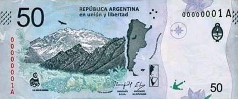
Mount Aconcagua, Argentina (Peso)
Aconcagua (6,960 m) is another Seven Summit and is the highest mountain in both the Southern and Western Hemispheres. It is located in the Andes mountain range, in the Mendoza Province, Argentina.
The first recorded ascent of Aconcagua was made in 1897 by Swiss guide Matthias Zurbriggen via the northern route. The guide was part of a team led by Edward Fitzgerald who attempted the mountain 8 times but never reached the top. The east side of the mountain was first successfully climbed in 1934 by a Polish. The route is now known as the Polish Traverse route and the glacier on the north-eastern side of the mountain is also called Polish Glacier. Actually, there are some of those, the largest being the Ventisquero Horcones Inferior of about 10 km long, which descends from the south face to about 3,600 m in altitude near the Confluencia camp. Two other large glacier systems are the Ventisquero de las Vacas Sur and Glaciar Este/Ventisquero Relinchos system of about 5 kilometres long. The mountain and its surroundings are part of the Aconcagua Provincial Park.
Nowadays, Aconcagua is one of the most popular mountains in South America to climb and every year an average of 3,500 people attempt to reach the summit. Aconcagua’s popularity stems from the fact that it is considered to be one of the easiest climbing peaks for its height. In fact, Aconcagua is often referred to as a highest ‘trekking peak’ in the world.
Aconcagua is part of the iconic Seven Summits circuit and nearly all the greatest climbers in history have stood atop its peak. Because of height and relative ease, Aconcagua is often used a warm-up climb for some of the more difficult peaks like Everest, K2 or Denali.
Sierra de Famatina, Argentina (Peso)
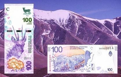
100-peso Argentinian banknote features the Sierra de Famatina mountain range in the Andes of the Argentine province of La Rioja. The Sierra de Famatina range rises between the north-south valleys of Bermejo and Antinaco-Los Colorados. The highest point, designated Cerro General Belgrano (once known as Nevado de Famatina), rises 6,250 m and is featured in the coat of arms of La Rioja Province.
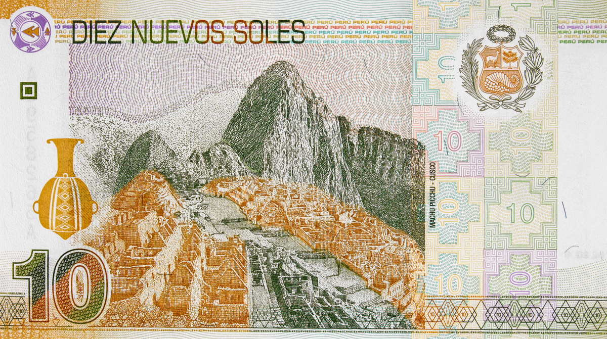
Machu Picchu, Peru (Sol)
Machu Picchu is nothing short of a wonder, even though it is not the tallest place (rising only 2,430m a.s.l.) it on every must-go-to list of any visitor to Peru. The place definitely has more historical and archaeological significance than pure mountain climbing delight, but climbing those stairs to the ancient abode is a challenge.
Often shrouded by mist, surrounded by lush vegetation and steep escarpments, the sprawling Inca citadel of Machu Picchu lives up to every expectation. Like the Mona Lisa or the pyramids, it has been seared into our collective consciousness, though nothing can diminish the thrill of being here. It is located in the Eastern Cordillera of southern Peru, the Cusco Region, Urubamba Province, above the Sacred Valley, which is 80 kilometres northwest of Cuzco and through which the Urubamba River flows, cutting through the Cordillera and creating a canyon with a tropical mountain climate. Machu Picchu was declared a Peruvian Historical Sanctuary in 1981 and a UNESCO World Heritage Site in 1983, you can read about Machu Picchu history here. In 2007, Machu Picchu was voted one of the New Seven Wonders of the World in a worldwide Internet poll.
The best months to visit are the dry months, which fall between May and September. The busy season really picks up from June to August, as a summer vacation in the northern hemisphere kicks into gear and national holidays in Peru are observed. But, you can try coming mid to late April, with Peruvian summer coming to the end and crowds being quite low. the Inca Trail is closed in February.
Whatever time you choose, make sure you book the Inca Trail reservations several months in advance – up to a year if you're going during peak season. You can only visit with a licensed agency, and spots book up quickly. Choose your trekking agency carefully. Shop around and ask lots of questions: what you'll have to carry, how many people to a tent, how many porters for the group, if there are arrangements for special diets. It's worth paying more for a reputable agency that treats its porters well and respects the environment. Bring warm clothes, because the trail gets cold at night and make sure you don’t suffer from altitude sickness. The biggest mistake you can make is to fly directly to Cuzco (3,326m) and expect to hike the next day. Give yourself a few days to adjust to the altitude first.
Should you fail to plan well in advance, or if you simply cannot get the Inca Trail booking, there are still plenty treks around Cuzco.
- The 4 to 5 day Salkantay Trek begins just a few hours outside of Cusco and ends in Aguas Calientes (where you can then access Machu Picchu), and is full of breathtaking natural views the entire way.
- No permits are needed for the Lares Trek, a quickie for a 2 to -day hike in the Andes full of turquoise lakes and indigenous communities.
- Head to the Amazonas region in northern Peru to visit Kuélap, a massive stone wall fortress that sits at a higher altitude than Machu Picchu and is about 500 years its elder.
- An eight-hour bus ride north of capital city Lima is your ticket to Cordillera Huayhuash in Huaraz, a favourite of adventure junkies.
North America and Australia
Sadly, the highest peak of North America, Denali (6,190m), the third most prominent and third most isolated peak on Earth, after Mount Everest and Aconcagua, has never made it to US banknotes. Neither has Mount Logan (5,956m), the highest mountain in Canada, appeared on the country’s money. To aggrieve you more, none of the 100+ North American four-thousanders made it to the banknotes.
Likewise, the highest Australian mainland highest mountain - Mount Kosciuszko (2,228m a.s.l) a part of the Australian Alps National Parks and Reserves - has not appeared on the Australian dollar as well.
Or, we have failed to find them on the banknotes which reverse sides are filled with coffee, cigars, animals, plants, old temples or simply numbers. We would appreciate any info we might have missed, just to make the system perfectly symmetrical: every continent has a mountain, thus at least one banknote from a continent should have a mountain. Let’s roam the world and make life perfectly balanced.