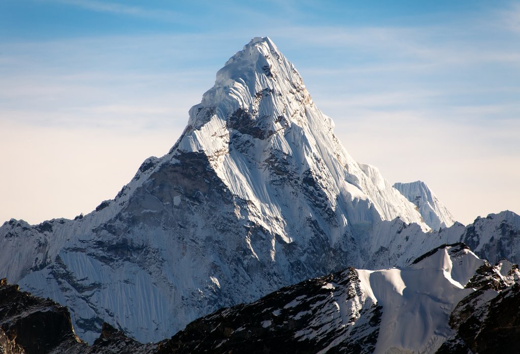
Ama Dablam is a mountain in the eastern Himalayan range of Koshi Province, Nepal. The main peak is 6,812 metres (22,349 ft), the lower western peak is 6,170 metres (20,243 ft). Ama Dablam means "mother's necklace"; the long ridges on each side like the arms of a mother (ama) protecting her child, and the hanging glacier thought of as the dablam, the traditional double-pendant containing pictures of the gods, worn by Sherpa women. For several days, Ama Dablam dominates the eastern sky for anyone trekking to Mount Everest Base Camp. For its soaring ridges and steep faces Ama Dablam is sometimes referred as the "Matterhorn of the Himalayas." The mountain is featured on the one rupee Nepalese banknote.
Ama Dablam was first climbed on 13 March 1961 by Mike Gill (NZ), Barry Bishop (US), Mike Ward (UK) and Wally Romanes (NZ) via the Southwest Ridge. They were well-acclimatised to altitude, having wintered over at 5,800 metres (19,029 ft) near the base of the peak as part of the 1960–61 Silver Hut expedition, led by Sir Edmund Hillary.
Situated at a distance of 162 km (101 mi) north of the provincial capital of Biratnagar and 152 km (94 mi) northeast to Kathmandu, Ama Dablam is the third most popular Himalayan peak for permitted expeditions. The most popular route by far is the Southwest Ridge (right skyline in the photo). Prior to a 2006 avalanche, climbers typically set up three camps along the ridge with Camp III just below and to the right of the hanging glacier, the Dablam. Any ice that calves off the glacier typically goes left, away from the camp. However, after the avalanche, climbers now prefer to set just two camps to minimize risk. Camp I is at an altitude of over 5,800 metres (19,029 ft), and Camp II is at an altitude of over 6,000 metres (19,685 ft). A climbing permit and a liaison officer are required when attempting Ama Dablam. As with Mount Everest, the best climbing months are April and May (before the monsoon) and September and October.
By elevation Ama Dablam is
# 28 out of 83 in Sagarmatha National Park # 47 out of 212 in Eastern Development Region # 32 out of 99 in Solukhumbu
By prominence Ama Dablam is
# 45 out of 866 in Nepal # 7 out of 83 in Sagarmatha National Park # 15 out of 212 in Eastern Development Region # 10 out of 99 in Solukhumbu
We use GPS information embedded into the photo when it is available.
3D mountains overlay
Adjust mountain panorama to perfectly match your photos because recorded by camera photo position might be imprecise.
Move tool
Rotate tool
Zoom
More customization
Choose which peak labels should make into the final photo and what photo title should be.
Next
Photo Location
Satellitte
Flat map
Relief map
Latitude
Longitude
Altitude
OR
Latitude
°'''
Longitude
°'''
Apply
Register Peak
Peak Name
Latitude
Longitude
Altitude
Register
Teleport
PeakVisor
This 3D model of Sagarmatha National Park in Nepal was made using the PeakVisor app topographic data. The mobile app features higher precision models worldwide, more topographic details, and works offline. Download PeakVisor maps today.
Download OBJ model
PeakVisor
The download should start shortly. If you find it useful please consider supporting the PeakVisor app.
PeakVisor for iOS and Android
Be a superhero of outdoor navigation with state-of-the-art 3D maps and mountain identification in the palm of your hand!