

Share

Scan the QR code and open PeakVisor on your phone
Scan the QR code and open PeakVisor on your phone
Located on the Thompson Plateau in British Columbia, Canada, Bonaparte Provincial Park encompasses nearly 12,000 hectares (30,000 acres) of wilderness, including forests, lakes, wetlands and several named peaks. Of the named peaks, there are two lava plugs, Skoatl Point (1,640 m/5,381 ft) and Bare Hill (1,574m/ 5,162 ft).
Bonaparte Provincial Park is located on the Bonaparte Plateau, which is part of the Thompson Plateau in the interior of British Columbia, Canada. The park was established in 1996 and encompasses nearly 12,000 hectares (30,000 acres) of wilderness. While the park was established to protect the ecological values of the area, it was also intended that pre-existing uses such as recreation, cattle-grazing, hunting, trapping, and backcountry tourism continue.
There is significant representation of high plateau settings in Bonaparte Provincial Park, such as lakes, forests, and hilly terrain with several named peaks in the park. Skoatl Point (1,640 m/5,381 ft) is the tallest peak in the park with a prominence of 157 m (515 ft) and it, along with Bare Hill (1,574 m/5,162), are volcanic plugs. Stockton Hill (1,571 m/5,154 ft) is the other named peak in the park and it has a prominence of 156 m (512 ft).
There is road access to the park via logging roads up Jamison Creek; however, road access to the vast park is quite limited. Float planes are another popular way to enter the park, especially for those visiting one of the commercial fly-fishing lodges.
The park plays a vital role in protecting the regional ecology of the Northern Thompson Uplands. Some of the other regional parks include Porcupine Meadows Provincial Park, Tsintsunko Provincial Park, High Lakes Basin Provincial Park, Emar Lakes Provincial Park, and Taweel Provincial Park.
The following is a list of other nearby parks that offer exciting wilderness opportunities:

The park is in an area that is frequently referred to as the Fraser-Thompson Plateau, which is the plateau region northwest of the city of Kamloops and is the transition area between the Fraser Plateau and the Thompson Plateau. The Fraser and Thompson plateaus are composed of smaller plateau regions as well as some minor mountain ranges.
Bonaparte Provincial Park is situated upon the Bonaparte Plateau, which is adjacent to the Tranquille Plateau, Kukwaus Plateau, and the Green Timber Plateau. The plateaus tend not to have any significant peaks but rather they have a rolling terrain which Bonaparte Provincial Park epitomizes.
The rolling and hilly landscape which is punctuated with many lakes was formed from lava flows millions of years ago. Indeed, the volcanic history of the park is seen in Skoatl Point and Bare Hill, which are lava plugs. Lava plugs occur when magma hardens in the vent of an active volcano.
While the underlying layers of Paleozoic sedimentary rocks of the Thompson Plateau may be hundreds of millions of years old, the basaltic lava and granitic intrusions in the region are much younger. Indeed, the volcanic rocks of Bonaparte Provincial Park are only about 60 million years old.
Around this same time, 60 million years ago, there was significant geological activity. West of the plateau, the older Columbia Mountains were rising higher, and the Rocky Mountains were forming.
This uplift was being caused by the subduction of the Farallon tectonic plate beneath the west coast and the accretion of the Insular Belt, which includes the Vancouver Island and Haida Gwaii, to the continental margin.
Furthermore, major volcanic eruptions occurred across the interior, including the terrain of Bonaparte Provincial Park, due to crustal thinning which occurs along subduction zones. The lava flows from 60 million years ago essentially overwrote the ancient topography to create the vast plateaus.
The final topography of the park was created during the Pleistocene, when the vast Cordilleran ice sheet creeped across the province. The ice sheet scoured the terrain, leaving behind only the most durable peaks and filling in the low-lying areas with glacial debris.
Bonaparte Provincial Park is a prime example of the ecology of the Northern Thompson Uplands. The park is in a climatic transitional zone between the warm and dry climates of the south, and the cooler and wetter climates of the north. As such, the park tends to have warm, dry summers and cool, wet winters with significant snowfall.
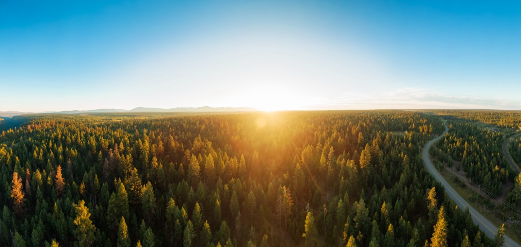
The park encompasses montane and subalpine forests, lakes, meadows of sedge, creeks and streams, and marshy areas. At the higher elevations of the park, the short growing season allows for only the hardiest of the region’s trees to grow. Engelmann spruce, subalpine fir, and lodgepole pine are the dominant trees at the higher elevations.
However, the lower areas of the plateau park also have forests of hybrid Engelmann and white spruce, Douglas fir, and trembling aspen. The forests cover much of the park with a dense canopy and dense undergrowth covers the ground between the trees. However, there are still some glades and meadows scattered across the park that contain wonderful displays of wildflowers, especially the fairyslipper orchid.
Between the lakes the landscape is often wet and marshy, creating habitat for many species of waterfowl. The wetlands as well as the forests are home to moose, mule deer, black bears, cougars, wolves, and many birds. One of the noteworthy species that visits the park is the sandhill crane which regularly nests in the park.
The Deadman Creek system contains the source of the park’s indigenous rainbow trout population. From the 1930s, fishermen and fishing camps stocked many of the park’s barren lakes with the indigenous stock of rainbow trout, which is considered of regional significance. Most of the lakes manage to naturally maintain their population levels as there are many spawning habitats along the many interconnecting creeks.

Recreational use of the park has been carried on for the better part of a century, with the focus on fishing at the many beautiful wilderness lakes. As road access into the park is limited, the four commercial lodges in the park are typically fly-in, with float planes landing upon the lakes.
The lodges are one of the few remaining places in the southern interior of the province where visitors can come and enjoy the wilderness in safety and comfort. While the lodges have traditionally been used for fishing excursions, there is a growing trend for visitors to simply want to enjoy hiking, nature study, and wildlife viewing in an uncrowded and quiet wilderness setting.
Furthermore, the park has a long history of ranchers grazing cattle throughout the park area, at least since the 1930s. There has also been a history of logging in the park; however, less than 10% of the park was affected by previous logging.
Before the settlers found that fishing in the park’s many lakes was a wonderful hobby, the park’s resources were harvested by the local indigenous groups. Bonaparte Provincial Park is in the traditional territory of the Secwepemc (Shuswap) First Nation.
While there are no specific sites within the park to suggest habitation, the region has been inhabited by humans for about 10,000 years. For countless generations indigenous groups likely hunted and foraged around the many lakes and the hills of Bonaparte Provincial Park.
The landscape of Bonaparte Provincial Park is filled with dense forests, dozens of lakes, and hills that give a vantage of the surrounding terrain. The following are the most popular trails and activities in Bonaparte Provincial Park.
Located along the east side of the park, Skoatl Point is the tallest of the park’s hills and provides a stunning view of the region from the summit. From the trailhead, which is located near the southeast corner of the park, the trail is about 5 km (3 mi) to the summit of Skoatl Point.
The trail is generally pretty flat until you reach the base of the hill, at which point the hike turns into a bit of a scramble. The trail is considered easy, and it has a total elevation gain of about 400 m (1,300 ft). While the trail is typically easy to follow, forest fires have ravaged part of the park and have obscured the original path.
Skoatl Point is one of the two lava plugs in the park, the other is Bare Hill in the northwest corner of the park. The lava plugs of Bonaparte Provincial Park were formed millions of years ago when lava cooled within volcanic vents.
Visitors have been enjoying fishing in the lakes of Bonaparte Provincial Park for nearly a century. There are four commercial lodges in the park that fly their guests in for the opportunity to stand upon the peaceful shores and test their skill against the local rainbow trout.
Visitors can also come independently to fish in the lakes of the park and simply camp in the wilderness. While access can be tricky, there are many paths throughout the park that lead to the different lakes.
With over fifty lakes, there are many opportunities for enjoying the peaceful tranquility of paddling across a wilderness lake. Since the park has been used recreationally for so long, while there are no official trails in the park, there are many routes for hiking and portaging between the lakes. It is possible to enjoy paddling for days as visitors follow a circuit across the many lakes.
The Thompson and Fraser Plateaus surrounding Porcupine Meadows Provincial Park are home to rugged wilderness areas. The following are some of the major cities and towns that you can stay in while exploring Porcupine Meadows and the region’s other cultural sites, stunning rivers, beautiful landscapes, and rugged mountain peaks.
The city of Kamloops was established along the Thompson River about 40 km (24 mi) south of Bonaparte Provincial Park. While Kamloops is known as the Tournament Capital of Canada because the city hosts over 100 sports tournaments each year, there are also many beautiful wilderness areas to explore near the city.

Some of the popular hiking areas closest to the city are Kenna Cartwright Nature Park along the south side of the city and Lac du Bois Grasslands Protected Area which is just northwest of Kamloops. Other nearby wilderness areas include Tunkwa Provincial Park, Greenstone Mountain Provincial Park, and Mount Savona Provincial Park.
The municipality of 100 Mile House is located about 70 km (42 mi) northwest of Bonaparte Provincial Park. The community marks the 100-mile (160 km) mark of the Old Cariboo Road from Lillooet to the Cariboo goldfields.
There are hundreds of lakes near the community that are popular for boating and fishing and vast tracts of wilderness that are suitable for other adventures. Hiking, cross-country skiing, and especially traveling the wilderness on OHVs are popular activities for locals and visitors.

The nearby wilderness areas include Schoolhouse Lake Provincial Park and Wells Gray Provincial Park. However, there are some great trails to follow around town, such as Bridge Creek Falls, 100 Mile Marsh, 108 Mile Lake and Sepa Lake Loop, and the Walker Valley Greenway.

Explore Bonaparte Provincial Park with the PeakVisor 3D Map and identify its summits.


