
Scan the QR code and open PeakVisor on your phone
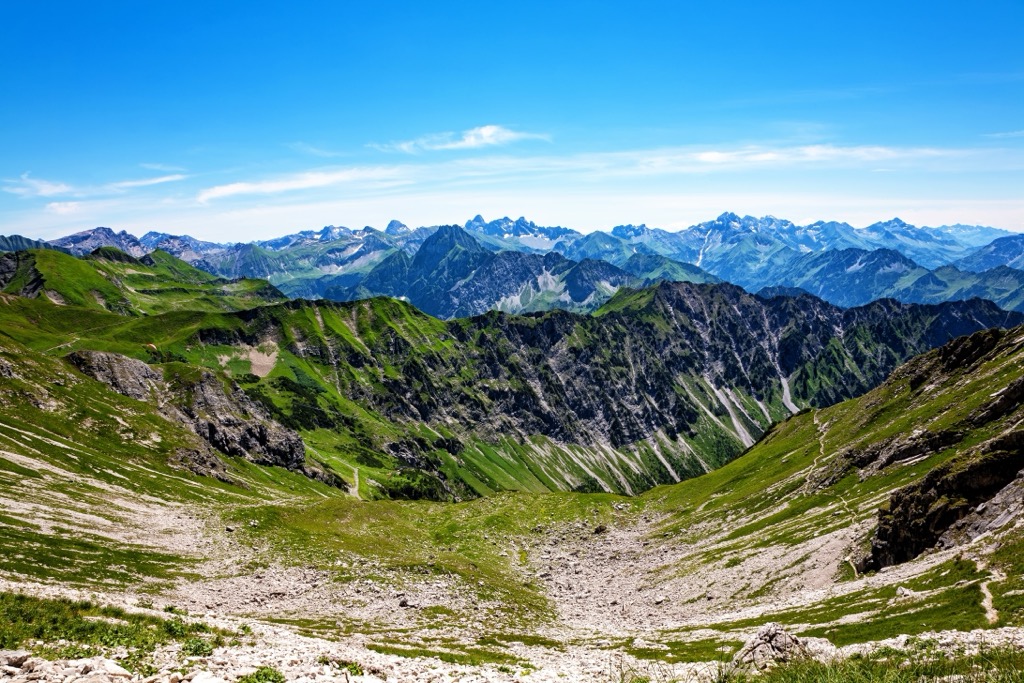
The Allgäu Alps, part of the North Tyrol Limestone Alps and Bavarian Alps, are located in Bavaria and Baden-Würtenberg in Germany and Tyrol and Vorarlberg in Austria. Steep-sloped and boasting an impressive diversity of flora, the range is popular for hiking and climbing in summer and skiing and snowboarding in winter. There are 692 mountains. Großer Krottenkopf (2,656 m / 8,714 ft) is the highest. Kellenspitze (2,238 m / 7,343 ft) rises 1,092 m (3,583 ft) from its surroundings, making it the most prominent peak.
The Allgäu Alps are part of the North Tyrol Limestone Alps and the Bavarian Alps. They span Bavaria and Baden-Württemberg in Germany and Tyrol and Vorarlberg in Austria. The Tyrol section has two mountain subgroups – the Tannheim and Vilsalpsee Mountains. The range lies along the Tannheimer Valley and east of Lake Constance.

The range’s tallest peak, Großer Krottenkopf (2,656 m / 8,714 ft), is part of a side branch called the Hornbach chain that diverts from the main ridge and extends about 15 km (9 mi).
Three peaks make up the well-known group along the range’s main ridge. Composed of dolomite, these are Hochfrottspitze, the highest mountain of the Allgäu Alps in Germany; Trettachspitze; and Mädelegabel. Heilbronn Way (Heilbronner Weg) is a famous trail that runs about 100-150 m (330-490 ft) below the summit to the south and east.

Easily accessed from the southern German village Oberstdorf, the Allgäu Alps are a famous skiing destination in Germany. Numerous resorts provide slopes for all levels and off-piste in upper sections.
Mädelegabel is among the most well-known and frequently climbed high peaks in the Alps. It contains up to 400 m (1,310 ft) tall rock faces, and a small glacier, Schwarzmilzferner, is tucked away on the southeast slopes.
The Allgäuer High Alps nature reserve in southwest Germany protects the upper reaches of the range and was named a Natura 2000 area in 2002, indicating its environmental importance and diversity. The reserve protects forests, alpine streams, moorland, and tarns.
The range is known in particular for its floral diversity and steep slopes. One classic characteristic is its grassy meadows that grow on steep mountainsides, known as grasberge in German.
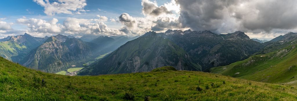
The Bregenz Forest Mountains border the Allgäu Alps to the west, the Lechquellen Mountains to the southwest, the Lechtal Alps to the south and southeast, and the Ammergau Alps to the east.

The Allgäu Alps are part of the Bavarian Alps, a series of ranges within the North Tyrol Limestone Alps, which are part of the greater European Alps. The range primarily comprises dolomite, sandstone, marl, and other sedimentary rocks.
The Alps formed during the Alpine orogeny, a mountain-building event that occurred as the African and Eurasian plates collided. This collision has been ongoing since Cretaceous times. Most mountain building occurred between 65 and 2.5 million years ago, although the mountains continue to uplift. However, the uplift rate no longer outpaces erosion, and the Alps are not considered a growing range.

Dolomite is one of the oldest rocks in the range, formed around 220 million years ago. Approximately 240 million years ago, the region was part of the supercontinent Pangea and partially surrounded by the Sea of Tethys. Shells from sea life, dead plants, mud, and sand sank and formed sedimentary rock layers over time. The Alpine Orogeny later uplifted these layers.

Another characteristic of the range is the weather-resistant aptych layers, which were formed deep in the ancient sea and feature a high silica content. Spotted marl is also quite resistant. This yellow-gray rock with dark spots formed in sea basins filled with lime mud. Dark spots in the rock come from trails carved out by worms that burrowed in the mud. Marl contributes to fertile soil, supporting lush alpine meadows and abundant wildflower bloom.
Glaciers from the past ice ages have shaped the range in recent geologic history. The presence and retreat of glaciers left behind moraines, glacial cirques, and deep valleys.
The Allgāu Alps are subject to abundant precipitation and snowy winters, with some areas receiving more than 300 cm (118 in) of yearly precipitation. The combination of steep slopes, high precipitation, and temperature fluctuations results in erosion, mudslides, and avalanches.
The dramatic elevation change also supports a wide range of ecological communities in a relatively short space, as each species is well adapted to distinct altitudes and conditions.
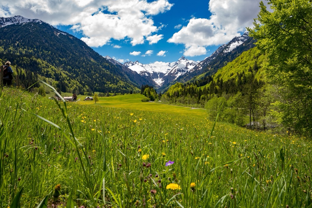
Mixed spruce-fir-beech is common and occurs at lower elevations. However, the mountains are mainly known for their steep grassy slopes. In summer, many alpine meadows burst into bloom, supporting numerous species of grasses, wildflowers, and shrubs.
Regarding wildlife, visitors may be able to spot ibex, chamois, marmots, foxes, deer, and hares. Birds found in the mountain include golden eagles, grouse, owls, and woodpeckers. Cows do not graze on the steepest slopes, but hikers may encounter them or hear cowbells when crossing plateaus or gentler slopes.

Celts inhabited the region of modern-day Bavaria over 2,000 years ago. They divided the area, and the southern portion near the Allgäu Alps was known as Raetia. During these early times, there were Roman colonies, such as the settlement at Kempten. The Romans rose to power around the year 0.
Germanic tribes overtook the Romans by the 5th century. The tribe responsible for the region’s name, the Baiovarii, settled there between 488 and 520 CE. In the 10th century, Bavaria became part of the Holy Roman Empire. Around this time, clashes with Hungarians were common and only laid to rest in 996 with the marriage of a Bavarian princess and a Hungarian prince.
In 1180, the Holy Roman Emperor gave Bavaria to the count palatine Otto of Wittelsbach, kicking off a dynasty that would rule the state until 1918. Centuries later, in 1918, the dynasty was overthrown in favor of a republic. The change took time, and political instability filled the proceeding years.
In 1948, Bavaria became a state. During this time, the region experienced economic shifts, such as the transformation from a primarily agricultural society to an industrial one.
Kempten is a notable town in the foothills of the Allgäu Alps. Although the precise founding date is unknown, the settlement dates back over 2,000 years to the early Romans. During the first century A.D. monks from St. Gallen arrived, creating the first monastic cell that grew into a monastery and then an ecclesiastical diocese with significant social sway.

The Catholic monastery and its benefactors ruled the town, inciting serfs and the working class to establish their own Kempten settlement nearby. The free city began in 1289 and was home mainly to traders and craftsmen. There was tension between the Catholic monastery and the Protestant free city, but both were absorbed by Bavaria in 1803 and merged in 1818.
The village of Oberstdorf is the southernmost village in Germany, with the Allgäu Alps on its doorstep. Today, it is the heart of winter and summer resorts for the country’s mountain tourism. The region has a long history of alpine farming; the valleys, plateaus, and gentler slopes still support livestock.

The Allgäu Alps are some of the best-known mountains in Germany for hiking, skiing, climbing, and via ferratas. The border between Germany and Austria runs along a portion of the range’s ridgeline. The village of Oberstdorf is a destination for its year-round resorts and wellness spas.

Several long-distance through-hikes traverse the range, including the European Trail E4 (Pyrenees-Creta), E5 (Atlantic-Adriatic Sea), and the Via Alpina. The 24 mountain huts offer cozy accommodations and hot meals.
The areas around Rote Flüh, Gimpel, Kellenspitze, and Gehrenspitze are popular with climbers. There are several ski resorts in the area, some of the best-known being Nebelhorn, Fellhorn/Kanzelwant, Oberstdorf/Riezlern, Balderschwang, and Nesselwang.

Heilbronn Way is one of the most popular routes in the Allgäu Alps. Created over a century ago, this high-altitude trail, supported by steel cables, climbs the slopes to follow the main ridge. This scenic route does require alpine experience, but the trail is exposed, and a few sections do not have cable support. The route is best completed between July and September.
The route begins below Hoher Licht. Early on, it passes through a crevice called Heilbronner Törle, which is a popular photo spot. At the end of the route, visitors can descend to Waltenberger Haus or extend their trail to Kemptner Hut. Those who wish to can summit Hohes Licht (2,651 m / 8,698 ft).
Mädelegabel (2,644 m / 8,675 ft) is the fourth-highest summit in the Allgäu Alps and one of the most popular hikes. The trail is 22.5 km (14 mi) with over 1,600 m (5,250 ft) of elevation change. The route and views are spectacular, but it’s a challenging hike; the final hour is an unsecured rock scramble.
The hike begins at Spielmannsau and can be reached by train from Oberstdorf. As it is a long day with the ascent and descent, many choose to overnight at Waltenberger Haus after summiting and complete the descent the following day. Another tip for hikers is to find a secure spot to leave their packs before the final push to the summit.
The area around Nebelhorn is excellent for both skiing and hiking. Nebelhorn includes many black slopes and the longest run in Germany, snaking 7.5 km (4.7 mi) down to the valley. The two recommended advanced options are the high-alpine Nebelhorn-Gipfelhang slope and the black slopes near the 10-person Nebelhorn 2 gondola. The upper part of the resort has abundant freeride terrain. You’ll find gentler slopes at the Seealpe if you're just starting out.
The Nebelhorn cable car is the highest in the region. It enables quick access to the mountain's slopes, trails, lodges, and huts, including an ice hotel called the Iglu Lodge.
During the warmer months, the lifts and trails convert to excellent hiking trails. The scenic via ferrata Hindelang is one of Germany's most famous. The route leaves from Nebelhorn, stretches around 5 km (3 mi) between Nebelhorn and Großer Daumen, and is supported by about 1 km (0.6 mi) of wire ropes and 100 m (328 ft) of ladders. Some rocky sections feature higher difficulty, and three emergency exits exist along the way for those who do not wish to complete the entire route.
Those who want to add a hike to reach the via ferrata can hike to Nebelhorn from Oberstdorf through Seealpe or Geißalpe.

Most of the Allgäu Alps lie in southern Germany and extend into Austria. The town of Kempten and the village of Oberstdorf are near the mountains in Germany. Munich is a much larger urban center only a few hours away, as is Innsbruck in Austria, which has an international airport.
With a population of a little under 70,000 people, Kempton is a small city in the foothills of the Allgäu Alps. The city is steeped in history, close to numerous all-season outdoor activities, and supports a vibrant dining, nightlife, and shopping scene. Visitors can sample traditional Bavarian cuisine like schnitzel, spätzle, and local sausage and beer. The city hosts a jazz festival in spring and Christmas markets in December.
If you’re keen to learn more about the town’s history going back over 2,000 years, the Archeological Park Cambodunum and the Allgäu Museum provide insight. Other sites include the monastery Abbazia d Kempten, the Burghalde - a Roman castle used today as a performance hall - and the nearby castle Neuschwanstein.

The village of Oberstdorf is home to less than 10,000 people but is famous for its proximity to the Allgäu Alps. Resorts operate during winter and summer, and guests can choose from luxury hotels or cozy guest houses. If you want to treat yourself after intense days in the mountains, check out one of the wellness spas in town.
From town, there is easy access to 200 km (125 mi) of hiking trails in summer and over 200 km (125 mi) of groomed in winter for both downhill and cross-country skiing. The Oberstdorf-Kleinwalsertal ski region has seven mountains, and the town hosts international sporting events like the Four Hill ski jumping tournament and the FIS Nordic World Ski Championships.

Munich has a population of 1.47 million and is in southern Germany. With cobbled streets, historic buildings, and plenty of restaurants and bars, the city is urban with a charming, historical feel. It is only a few hours from the mountains, and the train system makes getting to smaller mountain towns easy.
Be sure to visit one of the boazn, a genre of local dive bars well-known for their breweries and Oktoberfest celebrations. The city has many museums, from art galleries to more unique museums such as the Potato Museum (Kartoffelmuseum) and the Hunting and Fishing Museum (Jagd- und Fischerei-Museum). Many museums offer cheaper entry on Sundays.
Check out local farmers' markets year-round and the Christmas markets around the holidays. With excellent public transportation, it’s easy to navigate the city and get out to surrounding areas without having your own car.

With a population of over 310,000 people, Innsbruck is an excellent destination for culture, nature, and proximity to mountain sports. It is the second-largest city in the Alps, after Grenoble, France, but arguably offers better mountain access. The city lies in a valley with steep mountains rising steeply around it; cable cars like the Nordkette and Patscherkofel provide quick access to the slopes for hiking, skiing, mountain biking, and paragliding.
Visitors can stroll through Old Town or pay a few Euros to climb the Town Tower. The Hofkirche church has 28 bronze statues, while the Cathedral of St. James showcases Baroque architecture. The Schloss fortress, a medieval fortress turned Renaissance castle for Archduke Ferdinand II’s wife, displays armor and artwork. Innsbruck hosted the Winter Olympics in 1964 and 1976 and the 1984 and ‘88 Winter Paralympics; the stadiums still host sports events.
Purchasing an Innsbruck Card is a worthwhile investment if you want to go to multiple museums, ride some cable cars, and have free transport on buses, trams, and bikes. The passes can be purchased for 24, 48, or 72 hours.
Innsbruck is within a 30-minute drive from both Italy and Germany. It is possible to arrive by train from Venice, Munich, Salzburg, and Zurich. The city also has a small but busy international airport and is a launching point for the famous Tyrolian ski resorts.


