
Scan the QR code and open PeakVisor on your phone
Loyalsock State Forest is an outdoor recreation destination located in the US state of Pennsylvania that features dense forests along with multiple creeks and streams. The forest boasts a series of ridgelines and valleys, a type of landscape that’s common throughout the state. Loyalsock State Forest contains 37 named mountains. The tallest and most prominent peak in the forest is Robwood Mountain (2,349 ft/716 m).
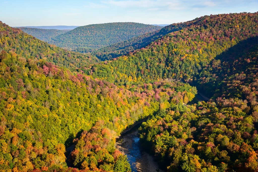
Loyalsock State Forest encompasses 114,552 acres (46,357 ha) of terrain, and it is located in the north-central part of the US state of Pennsylvania. The rolling hillsides and creeks of the state forest extend into three counties: Bradford, Lycoming, and Sullivan.
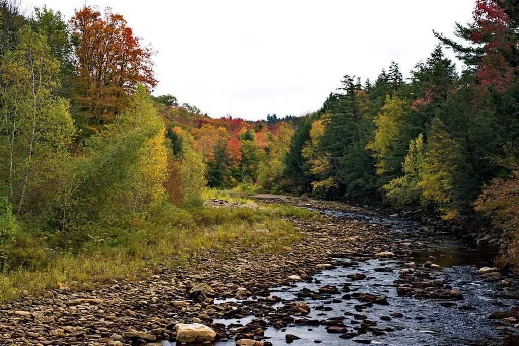
The forest is named after the main creek in the region, Loyalsock Creek. Other notable bodies of water in the region include Eagles Mere Lake, Hunters Lake, and Rose Valley Lake. Many of the smaller streams in the region are tributaries of Loyalsock Creek.
The forest lies within the Appalachian Mountains, which extend from the US state of Alabama up to the Canadian province of Newfoundland and Labrador. Loyalsock State Forest is part of a vast network of state forests that encompass much of the Appalachians in Pennsylvania.
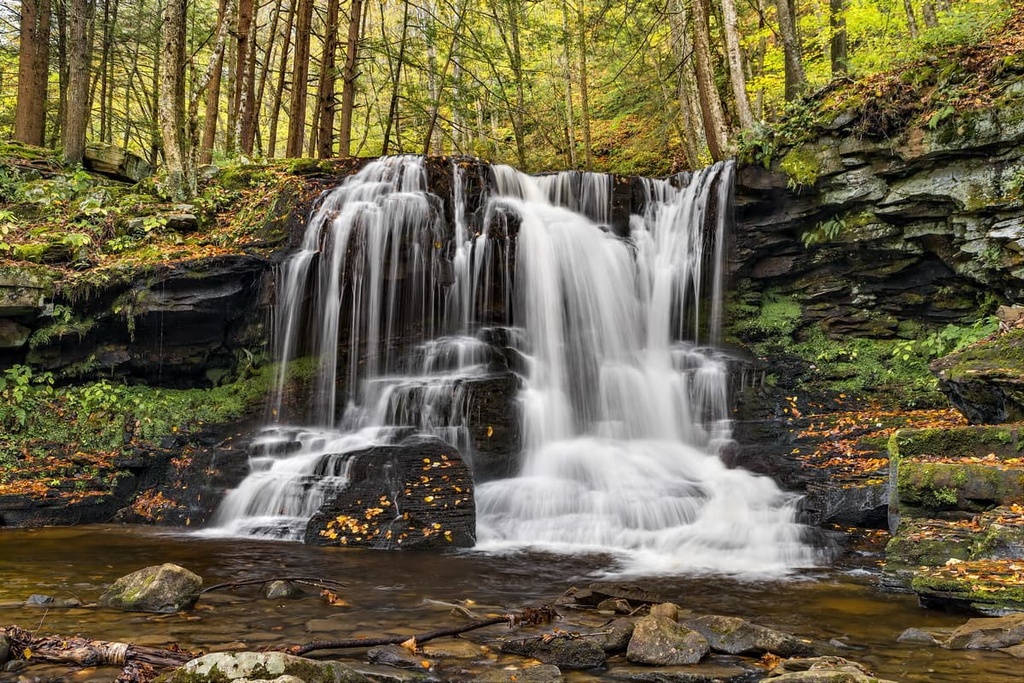
A majority of the forest in Pennsylvania is dominated by wooded hills and valleys. The various streams and creeks in the region have created multiple waterfalls throughout the state forest while rocky bluffs can be found in the forest’s higher elevation areas. Lower elevations in the state forest typically feature wetlands and bog terrain.
There are also numerous wild areas and natural areas that are located within the forest, such as:
Additionally, Loyalsock State Forest is located near numerous other parks and state forests. For example, Ricketts Glen State Park lies to the east of Loyalsock while Tiadaghton State Forest is situated to the west alongside Tioga State Forest, Asaph Wild Area, Old Bull State Park, and Cherry Springs State Park. A portion of Tiadaghton State Forest also lies directly to the south of Loyalsock along with Bald Eagle State Forest.
The peaks within Loyalsock State Forest are part of the Appalachian Mountains, which span across the eastern US and into Canada.
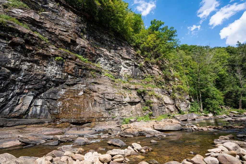
These peaks, along with the rest of the Appalachian Mountains, began forming around 480 million years ago. Faulting and folding of the Earth’s crust slowly thrust the range upward, changing the direction of the Susquehanna River in the process.
Over the course of the next 150 million years, the Susquehanna River began carving out a wide sweeping valley just to the south of the Loyalsock State Forest. Continual folding left behind the alternating network of valleys and ridges that define much of the region to this day.
During the last glacial maximum, much of Pennsylvania was covered in a vast sheet of ice. As temperatures rose, glacial runoff was added to the Susquehannock River, increasing the strength of its flow and slowly filling in the valley with sediment.
Loyalsock State Forest lies within the valley and ridge section of the Appalachian Mountains, while the Appalachian Plateau is situated to the north and the west. The bedrock in the forest and throughout much of northern Pennsylvania consists of sandstones and quartzites that formed during the Appalachian orogeny.
Major peaks located within Loyalsock State Forest include Robwood Mountain, Cove Mountain, Sugarcamp Mountain, Narrow Mountain, Jacoby Mountain, and Smiths Knob.
Loyalsock is home to flora and fauna that are commonly found throughout central and northern Pennsylvania. The network of state forests and parks in the region allows for a variety of species to flourish. While a majority of the region is densely forested, other portions feature streams, wetlands, bogs, and lakes.
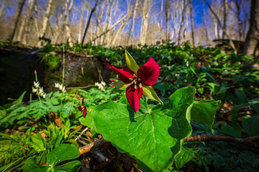
The forested sections of Loyalsock primarily contain black spruce, eastern hemlock, eastern white pine, and balsam fir. Both maple and chestnut trees are commonly found near the various waterways of the state forest. Flowers such as asters, goldenrod, dogwoods, mountain laurel, and sumacs bloom during the warmer months of the year.
The forest floor is often covered in low-growing plants such as wild carrots, Queen Anne’s lace, mayapples, and milkweed. The occasional redbud tree can be spotted along the steep hillsides of Loyalsock State Forest.
Mammals commonly spotted in the forest include white-tailed deer, cottontail rabbits, and ground squirrels. Porcupines and wild turkeys inhabit the grassy sections of the forest while bobcats live in the region’s forested hillsides.
Loyalsock Creek is home to a variety of trout, making it a popular spot for fishing. Larger birds that live in the region include great blue herons, wood ducks, and bald eagles. Smaller birds commonly spotted by bird watchers include northern mockingbirds, finches, sparrows, northern shrieks, and cardinals.
The land within and surrounding Loyalsock State Forest is part of the ancestral homelands of many Indigenous peoples, primarily the Susquehannock. The Susquehannock are an Iroquoian people whose traditional territory extends throughout what is now the northeastern US.
Many of the Indigenous peoples in the region lived relatively harmoniously with one another and the land for thousands of years. A majority of the early Susquehannock settlements were centered around the Susquehannock River, which runs through central Pennsylvania, just to the south of the forest. While the Susquehannock people lived primarily in central Pennsylvania, bands of the tribe are thought to have traveled and settled as far west as present-day Ohio.
When European settlers began arriving in the region, the Susquehannock started to form unions with other nearby tribes. The first recorded contact between Indigenous people and European settlers in the region occurred around the beginning of the seventeenth century.
Initially, the Susquehannock people resisted joining the Haudenosaunee (Iroquois Confederacy). Instead, they began forming alliances with the Swedish and Dutch settlers in the region. Together these settlers and Indigenous people were able to unite and fight against the colony of Maryland throughout the mid-seventeenth century.
The Indigenous population of the region was greatly diminished by the end of the seventeenth century from the arrival of diseases such as measles and smallpox that were brought over by the Europeans. Due to the decline in their population, the Susquehannock people were soon overtaken by the Haudenosaunee.
In the decades that followed, many Susquehannock people were relocated to near the Oneida Nation in present-day New York. Eventually, in the mid-eighteenth century, some Susquehannock people were able to return to the Susquehannock River Valley.
Despite the Susquehannock’s claim to the land and their efforts to protect the region, they were forcibly removed from their homelands by settlers and the US government. Widespread logging and mining took place throughout central Pennsylvania in the mid to late nineteenth century. A vast majority of the old-growth forests in the region were destroyed in the process.
Conservationists soon feared the land may never recover, so they began working to protect the region by forming the State Forest system. The Loyalsock State Forest was established in 1929, along with many other state forests in Pennsylvania. Today, the forest is home to a vast network of trails and campgrounds for visitors to enjoy.
Loyalsock State Forest is home to a number of excellent trails for outdoor recreation. High Knob Overlook offers stunning views of the forest and is accessible by car with no hiking required.
If you’re looking for a trail for your next hiking trip in Loyalsock State Forest, however, you’ll have plenty of options to choose from. Here are a few of the trails that you can find within the forest that are worth checking out during your next visit to the region.
Loyalsock Trail is perhaps the most well-known route in the forest and the surrounding region. This point-to-point hike traverses across the entire forest. Hikers completing this route are rewarded with stunning landscapes throughout as it passes along various creeks, lakes, ponds, and waterfalls.
Sections of the path can be quite muddy and rocky, adding to the difficulty of the trail. Hikers also have the option of completing a day hike along the route. The entire trail is 59 miles (95 km) long and it has 10,449 feet (3,185 m) of elevation gain. About halfway through the route, the trail passes through the Kettle Creek Wild Area.
The Old Loggers Path is a backpacking trail situated in the heart of the forest. This loop trail starts and ends in Masten along Pleasant Stream. Throughout the route, hikers are met with densely forested hillsides, sweeping views, and multiple streams.
The deciduous trees in the region provide an ever-changing landscape throughout the year. This route is 27 miles (43.5 km) long round-trip and it has 3,727 feet (1,136 m) of elevation gain. True to its name, this trail roughly follows old mining routes that date back to the nineteenth century.
The Angel Falls Trail is a shorter route that takes hikers to one of the many stunning waterfalls found within the forest. This trail starts out flat before climbing steadily uphill as you make your way to the falls. It then drops a bit in elevation as you arrive at Angel Falls.
On this trail, hikers can witness water cascading down the rugged and jagged rock face of Angel Falls. Due to its close proximity to the falls, the trail is often quite wet. This makes some of the rocks on this trail quite slippery, so take care during your adventures. This entire hike is 3 miles (4.8 km) long round trip and it has 777 ft (237 m) of elevation gain.
Looking for a place to stay near Loyalsock State Forest? Here are some of the best cities and villages to check out in the region.
The city of Williamsport lies just to the south of Loyalsock State Forest. Williamsport has a metro population of around 114,000 people, making it the most populous city in central Pennsylvania. As a cultural and economic hub for the region, Williamsport is also a popular tourist spot for those wishing to explore the numerous state forests that the region has to offer.
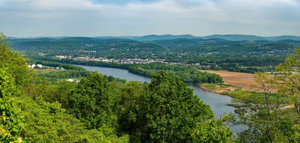
Williamsport is home to Pennsylvania College of Technology and Lycoming College. The city is known for being the birthplace of Little League Baseball, and each year it hosts the Little League World Series. Besides the city’s close proximity to multiple state forests, Williamsport is also surrounded by nearly 300,000 acres (121,400 ha) of state gameland, so it attracts an array of visitors looking for outdoor recreation opportunities.
Wilkes-Barre lies to the southeast of Loyalsock State Forest. Situated in the heart of the Wyoming Valley, the city of Wilkes-Barre is home to around 45,000 residents. The nearby city of Scranton has around 76,000 residents, so the two cities combined create a sizable metro area.
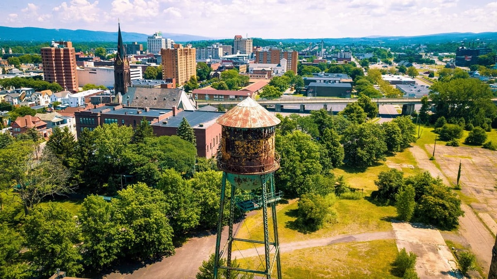
Originally established as a coal mining town in 1770, Wilkes-Barre now serves as a hub for outdoor recreation in the region. Since Wilkes-Barre is situated along the Susquehannock River, the city offers plenty of great kayaking, whitewater rafting, hiking, and mountain biking opportunities.
Popular sites in the downtown region of Wilkes-Barre include the Luzerne County Museum, River Street Historic District, Wyoming Monument, and the F. M. Kirby Center for the Performing Arts. The largest art galleries in the city are the Marquis and the Sordoni, both of which are well worth checking out.


