
Scan the QR code and open PeakVisor on your phone
An abundance of birdlife reverberates in the uplifted forest plains of central Taiwan’s Aowanda National Forest Recreation Area (奧萬大國家森林遊樂區). The recreation area contains 7 named mountains, the tallest and most prominent of which is Mahuipufushishan (馬海僕富士山) at 2,618 meters (8,589 ft) in elevation.
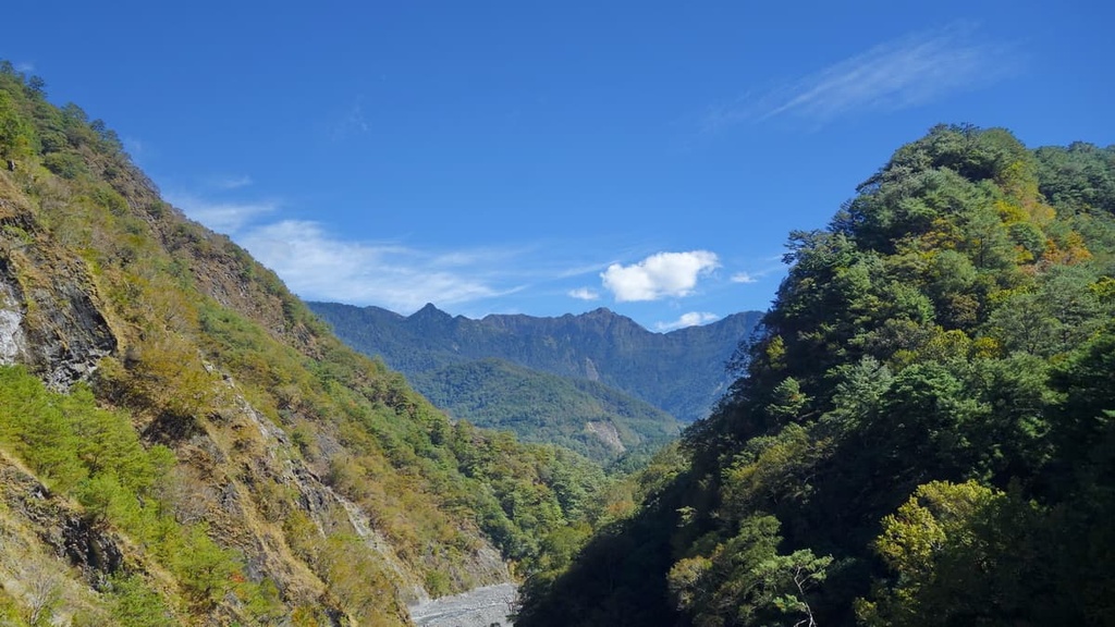
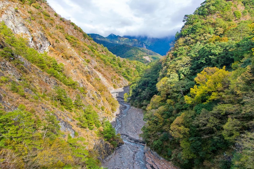
Aowanda National Forest Recreation Area is situated in the undulating region of central Taiwan’s Ren’ai Township (仁愛鄉) in Nantou County (南投縣). The forest covers 2,787 ha (6,887 acres) of hilly land, offering excellent views of the rugged backcountry of Nantou County.
The wooded plains of Aowanda National Forest Recreation Area are the traditional territory of the Seediq people of the Atayal tribe, who have lived and hunted in these densely forested hills for generations. Thus, the region is overflowing with the history and cultural heritage of the Seediq people.
The main attraction of this leafy hillside paradise is its rich wildlife habitats, countless bird species, spectacular waterfalls, and thriving maple forests. The elevation in the recreation area ranges between 1,100 to 2,618 meters (3,609 to 8,589 ft). As a result the park supports a vibrant collection of both deciduous broadleaf and evergreen coniferous plants.
An annual average temperature of a warm temperate 19°C (66°F) nurtures the thriving forests of maple, sweetgum, and beech in the park. Additionally, the flourishing forests of Aowanda produce an electrifying 45,000 ions per cubic centimeter (2,746 cu. in), creating a perfect atmosphere for the stress-hormone reducing activity of forest bathing.
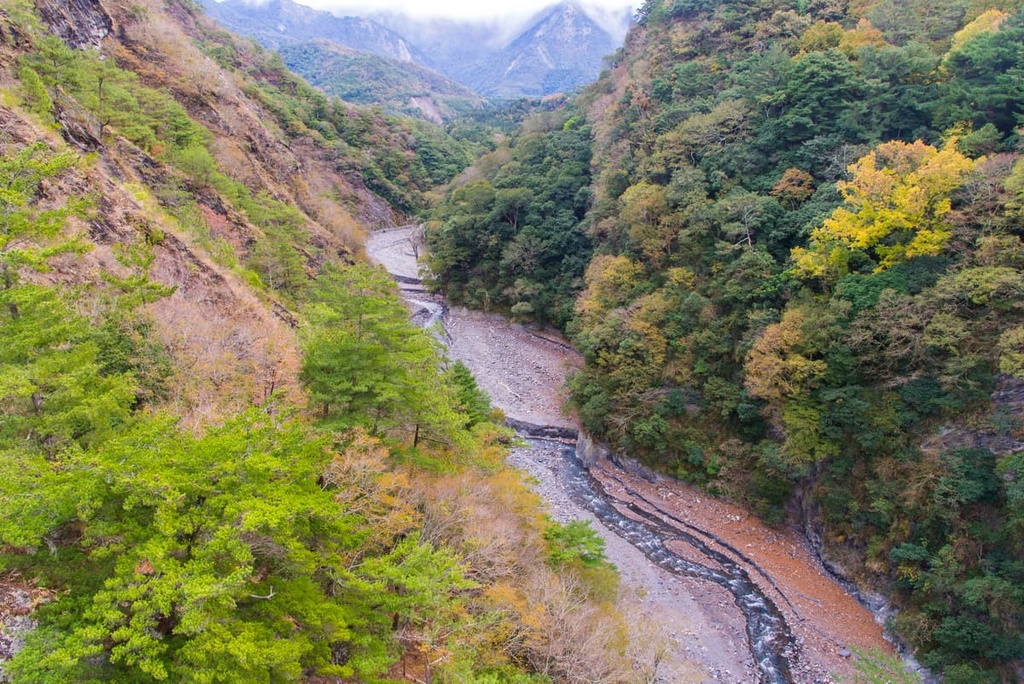
The sparkling curvature of the Wanda River (萬大溪) also winds its way along the southwestern region of the forest. Wanda River is a tributary to four other rivers: Naoliao (腦寮溪), Qingshui (清水溪), Bei (北溪), and Nan (南溪).
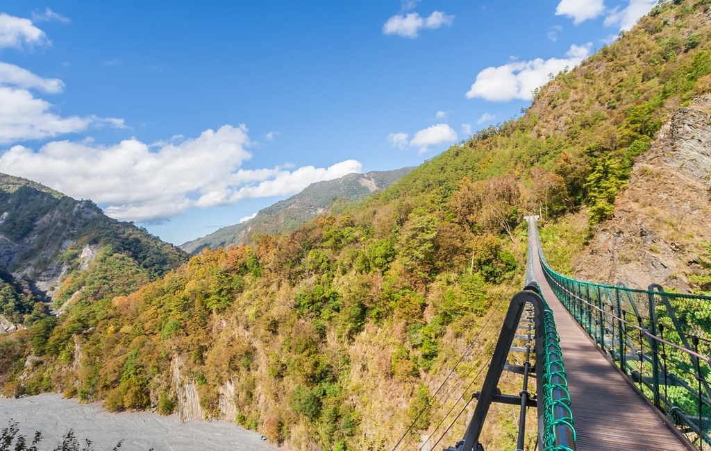
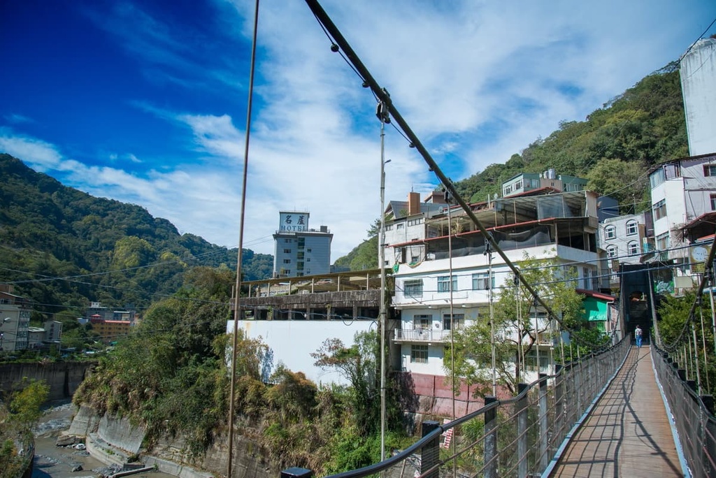
Additionally, the Aowanda Suspension Bridge extends across the surging waters of the Bei River in the park, offering hikers the chance to observe the region’s scenic beauty.
Central Taiwan is well-known for its staggeringly high peaks, especially those that are part of the Central Mountain Range (中央山脈). However, Aowanda National Forest Recreation Area hills are generally a bit flatter than the near-vertical mammoth peaks that you can see throughout much of the rest of the Central Mountain Range.
Mahuipufushishan, the highest peak in the recreation area, is located in the northern part of Aowanda. Beiwanda Shan (北萬大山) and Majun Shan (馬軍山) are the only two other peaks above 2,000 meters (6,562 ft) in the park.
As Aowanda National Forest Recreation Area is located in the heart of Taiwan, there are plenty of other places of interest surrounding it. To the east is the vast, expansive region of the Danda Wildlife Habitat (丹大野生動物重要棲息環境), while to the northeast are the precipitous marble slopes of Taroko National Park (太魯閣國家公園).
Additionally, the ever-popular and tranquil Sun Moon Lake (日月潭) is situated to the southwest of the recreation, while the emerald woodland of Basianshan National Forest Recreation Area (八仙山國家森林遊樂區) is located to the northwest.
Mahuipufushishan and the other summits around it are actually part of a massif that includes Nenggao Shan (能高山). Nenggao Shan is one of the 100 Peaks of Taiwan, which are also called Baiyue.
The Central Mountain Range runs from New Taipei City (新北市) in the north to the southernmost region of Pingtung County (屏東縣) in the south. Aowanda National Forest Recreation Area’s peaks are all part of the Central Mountain Range.
As the massif nears central Taiwan, the mountain’s incline and height swell massively, creating an inaccessible land pockmarked with layers of jagged peaks extending throughout the steep terrain.
Within the park, the major rock types are primarily sandstones and slates that date back to the Miocene, though there are some metamorphic outcroppings in the region, too.
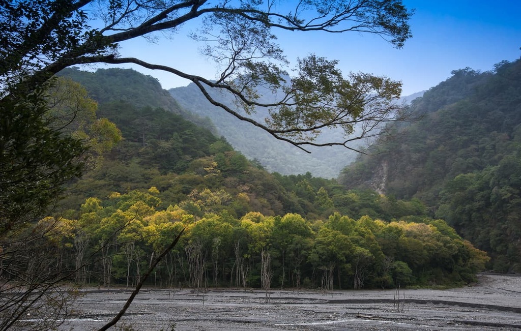
A thriving mix of broadleaf and coniferous plants is found throughout Aowanda, though the specific ecosystems that exist vary based on elevation in the park.
Below 1,100 meters (3,609 ft), the plant community in the region mainly features hardwood plants, such as Taiwan zelkova, Chinese pistache, and Formosan sweet gum.
As the elevation rises, specifically around 2,000 meters (6,562 ft), evergreen trees begin to appear, mixing with the autumnal hues of Taiwan green maple.
Taiwan hemlock and Taiwan spruce are found throughout this mixed forest zone. As the elevation increases further to 2,500 meters (8,202 ft) and beyond, the cold temperate evergreen trees of Taiwan red pine and Taiwan fir dominate the landscape.
Aowanda’s bird population is thriving, too, with over 120 bird species recorded in the region to date. Taiwan’s national bird, the blue magpie, dwells within Aowanda’s forests, making it a most welcoming sight for bird-watching enthusiasts.
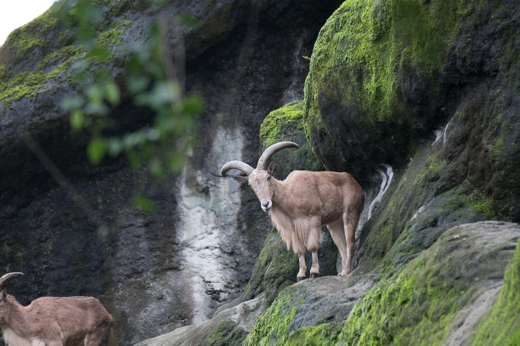
Meanwhile, some of the common mammals found in the region are Taiwan wild boar, Taiwan serow, Taiwan weasels, and Formosan rock macaques.
Situated near the Aowanda National Forest Recreation Area is the site of a historic uprising known as the Wushe Incident.
The incident began during the Japanese Occupation Era when members of the Seediq and Truku tribes were forced to relocate to a Japanese controlled stretch of land, known as the Nenggoa Yueling Guard Road. Japanese police officers stationed themselves along the road as they carefully tracked the movement of the tribal members who were forced to live under surveillance.
Eventually, the Seediq and Truku staged an uprising to fight back against the Japanese. As a result, the Seediq and Truku defended their homelands, protected their people, and fought in a three-month-long called the Battle of Taroko against the Japanese. However, outnumbered 2,300 to 20,000, the Seediq and Truku surrendered before more bloodshed occurred.
Afterward, these two tribal communities became increasingly frustrated by the oppression they faced living on the Nenggao Yueling Guard Road. The Japanese viewed them as inferior, treating the tribal members as second-class citizens on their native land.
In 1930, the two tribes planned the Wushe Incident where they ambushed a Japanese sporting event. During the ambush, they killed 134 Japanese spectators and injured 215 others.
After the incident, many Seediq and Truku people sought refuge in the Muhaipufushi Cave as the Japanese expanded their military presence in the region. After 50 days of hiding, the Japanese gassed the caves, causing the people who were hiding in them to suffocate.
The Muhaipufushi Cave is now a historic site, honoring the grit and fearlessness of Taiwan’s Indigenous people. Additionally, the Wushe Incident was the last large-scale uprising during the Japanese Occupation Era of Taiwan.
The following itineraries are the most popular hiking trails and areas in and around Aowanda National Forest Recreation Area.
The great peak of Muhaipufushishan stands tall in the northern part of Aowanda's lush forests. This moderate 5.5 km (3.4 mi) trek to Muhaipufushishan is a popular trail not only for historical reasons but for its pristine flora and its excellent views.
Hikers on this trail instantly feel the refreshingly cool mountain breeze making its way through the dense forest foliage. The entire course is shaded by countless clusters of hardwoods that transform into an enchanting evergreen environment as the elevation increases.
Climbing Muhaipufushishan is not devoid of challenges, as the trail is rugged and steep. However, Muhaipufushishan's woods are elegantly lush. A network of vibrant rhododendrons dominates the lower part of the trail, while a dense woodland dominates the upper elevations of the region.
While a pine forest partially covers Muhaipufushishan's summit, there are a few clearings that offer you limitless views of central Taiwan. Hikers can see Baigu Dashan (白姑大山) in the north, and Nenggoa Shan Nanfeng (能高南峰), Nenggoa Shan, and Andongjun Shan (安東軍山) to the east and south.
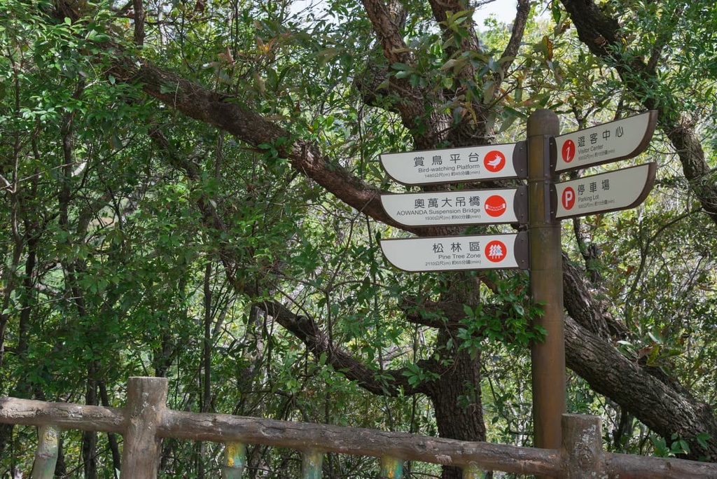
The Forest Park Trail starts in the center of Aowanda. It is approximately 1.4 km (0.8 mi) long and travels through a dense cork oak and Taiwan red pine woodland. The trail also follows along the banks of the Bei River and Nan River, which babble peacefully as you hike.
The Forest Park Trail intersects with the short Bird-Watching Trail, too, where you can go check out a small viewing platform that allows you to discover the thriving birdlife in Aowanda’s leafy forests.
Some of the many birds you might see in the forest include the Taiwan bush warbler, white-crested laughing thrush, red-breasted nuthatch, blue tit, and most notably, the Taiwan blue magpie. The mornings and late afternoons are the best times to catch sight of the birds in the park.
Near the end of the trail is the 90-meter high (295 ft) Aowanda Suspension Bridge, which spans 180 meters (590 ft). Visitors to the bridge are granted incredible views of high peaks and deep valleys as they cross this high suspension bridge.
The picturesque 1.6 km (1 mi) Waterfall Trail is one of the most popular hiking routes in the park. Here, the Naoliao Stream, a tributary of the Wanda River, forms into two waterfalls, Double Waterfall and Flying Waterfall.
As its name suggests, Double Waterfall is a two-tiered cascadel. Numerous wooden observation decks surround both waterfalls, allowing visitors to bask in the mesmerizing beauty of nature’s roar.
The tallest of the two waterfalls, Flying Waterfall, stands 48 meters (157 ft) high. Visitors are refreshingly bathed in its light mist as the vapor rises against the crash of the surging falls. Flying Waterfall produces the second highest level of ions in Taiwan; thus, visitors can take a moment to inhale the richness of negatively charged ions, increasing their overall mood and cleansing the body from any ailments.
Before the trail’s end, visitors venture to the Maple Viewing Platform, which offers great views of the vibrant display of maple woodlands on the banks of the Naoliao River.
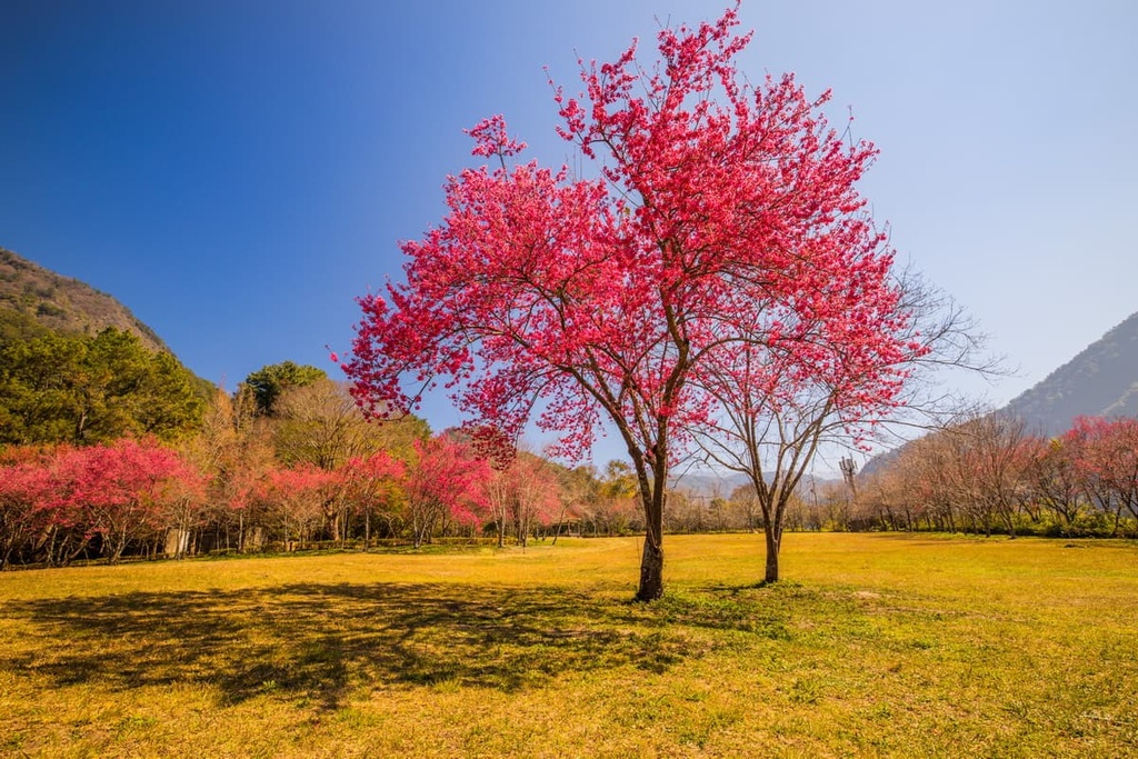
Visitors swarm to Aowanda National Forest Recreation Area in spring to view the gorgeous pink hues of cherry blossom season. While this trail is only 500 meters (1,640 ft) long, it boasts countless pastel pink cherry blossom trees for visitors to enjoy.
The 0.5 ha (1.2 ac) Aowanda Ecological Pond is situated along the Cherry Garden Trail. While strolling along this trail, you can also observe a number of other fascinating plant species including joyweed, tropical chickweed, and shell ginger. Pinewood tree frogs, central Formosan toads, and LaTouche’s frogs are a few reptiles that inhabit the Ecological Pond.
One of Aowanda’s most attractive features, Maple Forest Trail gives you a chance to experience the region’s beautiful maple trees. This 1.2 km (0.7 mi) path takes you deep into the park’s dense stand of maple trees, where you can admire the trees’ lush foliage.
While autumn and winter are the most picturesque seasons to frequent the trail, visitors can also enjoy the lush foliage in the spring and summer months. Here, Formosan sweetgum and Taiwan cypress intermix with the scarlet maple, too, providing superb views, even when you’re deep in the forest.
Known as the highest hot spring in Taiwan at an elevation of approximately 1,091 meters (3,579 ft), Lushan Hot Spring (廬山溫泉) offers dramatic mountain scenery and, if you visit in the spring, some stunning cherry blossoms.
The bicarbonate water of the hot spring is clear, odorless, and perfect for drinking. Locals believe that drinking the thermal liquid can ease gastric pain and flush acidity levels from one’s body. In fact, the water’s simmering temperature of 75 to 90°C (167 to 194°F) is even hot enough to boil eggs and cook raw noodles.
Nantou City (南投市) and Taichung City (臺中市) are the two closest cities to Aowanda National Forest Recreation Area. Here’s what you need to know before you plan your next trip to the region.
Compared to the more famous cities like historic Tainan, bustling Taipei, and the adventure haven of Hualien (花蓮市), Nantou City isn’t as popular; however, it offers excellent access to one of the biggest nature attractions in Taiwan: Sun Moon Lake.
Sun Moon Lake’s (日月潭) idyllic setting and glistening turquoise waters create a peaceful and tranquil ambience for visitor to enjoy. Boat rides on the lake are particularly popular, as visitors get to enjoy the scenic landscape while gliding on the lake’s smooth water.
Nearby Yushan National Park (玉山國家公園) is also a must-visit on every intrepid traveler’s bucket list when visiting Taiwan. Visitors can climb Yushan (玉山), Taiwan’s highest mountain, and venture on many other thrill-seeking trails, such as Batongguan Yueling Road, Southern Section Two, and the Xinkang Crosswalk Trail.
Often referred to as ‘Little Switzerland’ for its endless jagged outline of deep emerald hills, Qingjing Farm (清境農場) is a rustic homestead with cows and sheep grazing on its grassy hillside. The magnificence of Qingjing Farm is not only the dramatic landscape but also its seasonal wildflowers. Plum and pear blossoms appear in spring here, while summer ushers the sprouting of chrysanthemum and rhododendrons.
Nestled in the Bagua Shan (八卦山) massif lies the verdant Houtanjing Recreation Area (猴探井遊憩區). Although it’s known for its abundant monkey population, visitors to the recreation area are often most interested in crossing the thrilling 150-meter (492 ft) high Houtanjing Suspension Bridge. Visitors appreciate the enchanting views of colossal peaks jutting above the lush forest ceiling.

Another one of Nantou County’s top attractions is the Xitou Forest Recreation Area (溪頭自然教育園區), a 2,500 ha (6,177 acre) area of diverse plant life, such as ginkgo trees, Taiwan red cypress, and many varieties of bamboo. The charming arched bamboo bridge extending over Daxue Pond’s glistening aquamarine water is also well worth checking out.
The west-central city of Taichung is the third-largest metropolis in Taiwan, offering electrifying big-city vibes with a touch of slower-living than Taiwan’s capital, Taipei. Taichung provides ample opportunities to discover nature’s beauty within and surrounding the city.
The vast and flat landscape of the Goamei Wetlands (高美野生動物保護區) sits at the mouth of the nearby Dajia River. As a result, the area is rich in wildlife, as crabs, invertebrates, fish, and birdlife, including wild ducks, call this area home. Sunrise and sunset are incredibly stunning here, too, as the golden sky mirrors perfectly on the still wetland.
Head to Taichung’s Rainbow Village for a unique experience. The last remaining resident of the village’s former military barracks gave the barracks a cheerful facelift before leaving, painting playful patterns and whimsical drawings in bright, happy colors. A short walk around this fun mural is guaranteed to lift one’s mood—even on a cloudy day.
Alternatively, you could check out one of Taichung City’s many scenic parks, including the Maple Garden. Located next to Taichung Boulevard, this small green space features a quaint lake and a throng of maple trees. Despite its location next to a busy road, the garden much needed-tranquility. Locals enjoy observing the fish and turtles swimming in the lake while standing under the cool shade of the verdant, overgrown maple trees.
The bubbling 48°C (118°F) thermal Guguan Hot Spring (谷關溫泉) is also famed for its springtime cherry blossoms and autumnal blood orange maple leaves. Locals believe that the hot spring waters ease arthritis and dissipate stomach problems. As the springs sit at 800-meter (2,624 ft) elevation, it also provides some superb views of the surrounding region.

Or, you could check out Taiwan’s first coffee bean producing farm, the expansive Huisan Forest Recreation Area (惠蓀國家森林遊樂區). Huisan Forest boasts pristine old growth forests. Visitors to the forest can admire the surrounding views of smaller mountains, with the Central Mountain Range’s gigantic peaks dominating the landscape in the background.
Visitors to Aowanda National Forest Recreation Area can journey there on the Taiwan High-Speed Rail (HSR) or local express train (TRA) to Taichung City. The Nantou Bus runs from both of these stations, and it transports passengers straight to Aowanda National Forest Recreation Area.
Alternatively, for those wishing to make their own way to Aowanda, it is just a 95 km (59 mi) drive from Taichung City.


