
Scan the QR code and open PeakVisor on your phone
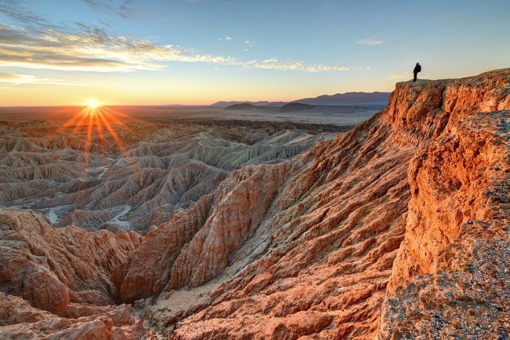
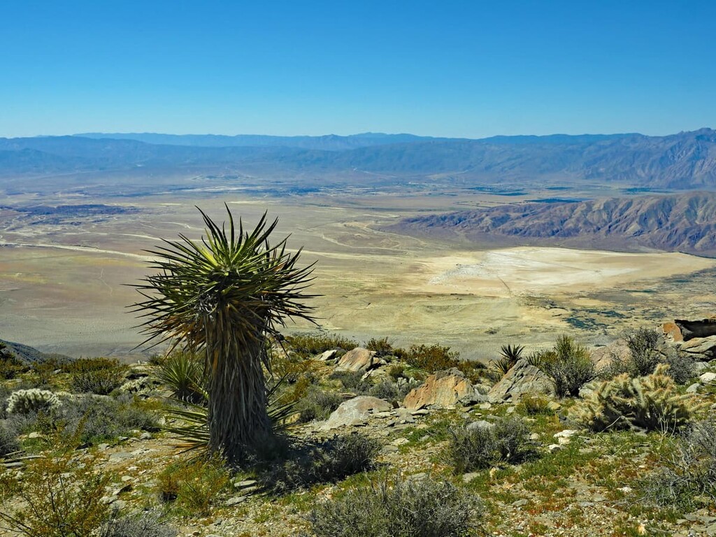
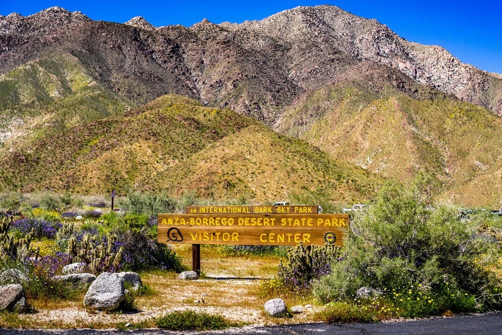
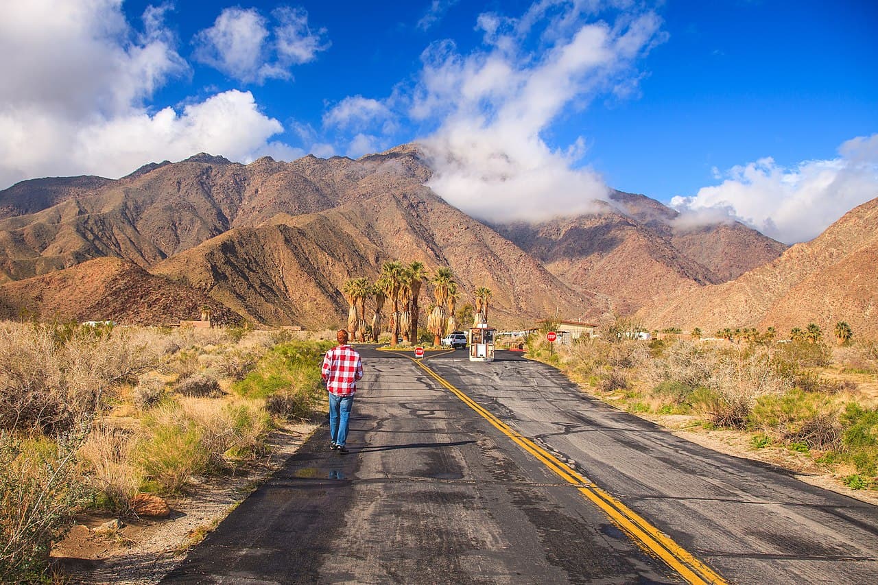
Known for its rugged and arid landscape, Anza-Borrego Desert State Park is one of California’s most beloved state parks. It is also the largest state park, with 585,930 acres (237,120 ha). The park is also home to 40 named mountains, the highest of which is Combs Peak (6,188ft/1866m) and the most prominent of which is Whale Peak (5,341ft/1,628m).
Anza-Borrego Desert State Park is located within San Diego, Riverside, and Imperial Counties in the US state of California, and it encompasses a patchwork of other publicly-owned and protected lands.
Its southern terminus is along the United States’ border with Mexico, just north of I-8. To the southeast, Anza-Borrego is bordered by the Jacumba Wilderness Area and the Jacumba National Cooperative Land and Wildlife Management Area.
The Salton Sea, as well as the Santa Rosa Wilderness and the Santa Rosa and San Jacinto Mountains National Monument form Anza-Borrego’s northern and northeastern borders. The Pine Creek Wilderness, Cuyamaca Rancho State Park, and the Cuyamaca Mountain State Wilderness are located to the west of the park.
Moreover, Anza-Borrego Desert State Park is situated to the east of the Cuyamaca Mountains, which separate it from the city of San Diego. The Salton Sink, the Imperial Valley, and the rest of the Mojave and Colorado Deserts separate the park from the Laguna Mountains to the east along California’s border with Arizona.
Anza-Borrego is a popular destination for geologists, biologists, hikers, and night sky gazers alike. Deemed a ‘dark sky’ community, many activities in the park revolve around stargazing and night hiking. During a full moon, hikers can walk around the park with the need for a flashlight. On darker nights, the milky way is visible and among the clearest views in the US.
Anza-Borrego Desert State Park is a point of interest for many geologists. The mountains in the park are predominately part of the Santa Rosa Mountains, which are a subrange of the California Ranges.
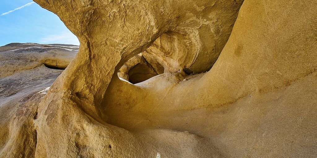
Bajadas, or collections of alluvial fans, are also a common sight. An alluvial fan is a triangle-shaped deposit of gravel, sand, and even smaller pieces of sediment, such as silt. This sediment is called alluvium. Alluvial fans are usually created as flowing water interacts with mountains, hills, or the steep walls of canyons.
Anza-Borrego is covered in a variety of metamorphic and igneous rocks that hint at the park’s volcanic and tectonic past. Ancient granite was deposited 100 million years ago as magma, which later cooled slowly, and hardened, giving Anza-Borrego’s granite its characteristic speckled crystalized look. After another few million years of weather and erosion the granite has broken apart the granite into the sand that covers the park.
Amongst the granite rocks, visitors will also see lighter and darker toned rocks dappling the landscape. These are tonalite, which is a mixture of feldspar and mica. Hikes such as the Narrows Earth hike highlight some rock cliffs with geologic structures that were formed 450 million years ago in places as far off as Guaymas, Mexico that have slowly made their way north to the park.
While there is a great deal of metamorphic rock present in the park, there are more and more sedimentary rocks forming (thanks to the alluvial fan structures), which will only increase as the park’s diversity of rock formations erode and get pressed together by the forces of nature.
These formations are typically seen as streaks along the sides of mountains. These streaks formed as water flowed down from the high desert into the valley, eroding, moving, and depositing part of the mountain into the valley below. The ever-developing sedimentary rocks are also a sober reminder to guests that flash floods in the park are not only to be expected, but respected and avoided at all costs.
Another notable geologic phenomenon in Anza-Borrego is called desert varnish. It is not clear how exactly desert varnish forms. But scientists theorize that microscopic bacteria living in the rock absorb manganese and iron oxide, causing them to become blackish and red in hue, creating the varnish.
Additionally, the park is located along the western edge of what’s known as the “Salton Trough.” The trough is a major low point in the region, and is located along a continental plate boundary.
Throughout the last 7 million years, the region saw massive deposition of sediments along the plate boundary. These sediments are rich in fossils, which provide ample evidence of the region’s paleontological past.
Interestingly, about 6 million years ago, the Salton Trough was filled with sea water from the ancient Gulf of California. During this time, large numbers of fossils were deposited in the area. Over the millenia, the region transitioned away from a marine environment into a terrestrial one as the sea dried up.
The fossil record of Anza-Borrego Desert State Park is particularly interesting, as paleontologists have unearthed hundreds of different fossils, including pollen, spores, mammoth skeletons, and baleen whale bones.
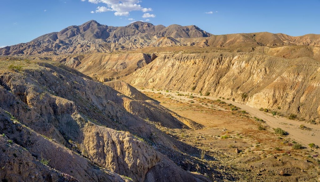
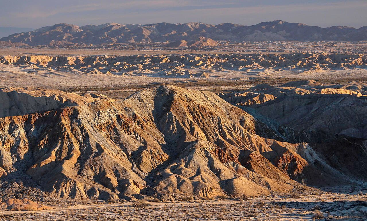
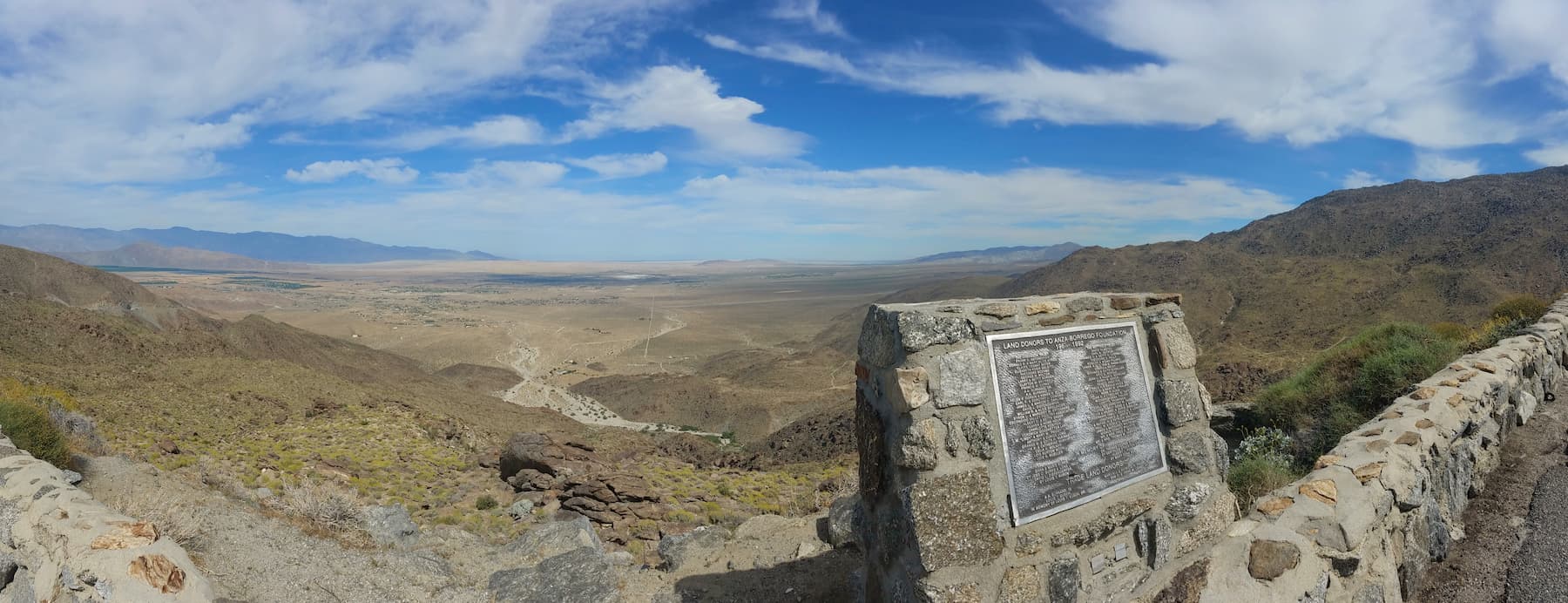
If you are really interested in seeing Anza-Borrego’s geologic highlights then you should take a trip down ‘Erosion Road,’ a 21-mile (33.8 km) strip of land east along S22. This drive will take you through the Borrego Badlands and takes about an hour to drive from start to finish. This drive has 12 designated stops, the first of which is just past the Borrego Spring airport at Mile Marker 23 on Palm Canyon Drive, which is called Font’s Point View.
Font’s Point View highlights the red brown and greenish sediment layers of the lower Borrego Badlands.
These bands were deposited by alluvial fans 300,000 to a million years ago. Below them are pinkish-brown layers of sediment that are from the bottoms of ancestral freshwater lakes that were present 1 to 3 million years ago. The bands hint at the area's history as a savannah with lakes and streams millions of years ago. Mammoths, sloths, zebras, and sabretooth cats roomed the land at that time.
Coyote Mountain (3192ft, 973m) at Mile Marker 27 is your next stop. The mountain stands alone now, but was once in line with the rest of the Santa Rosa Mountains. This range, and Coyote Mountain, stretches along the San Jacinto Fault, which moves the mountain bit by bit each year.
The San Jacinto Fault is the most seismically active in California and it causes 3 to 4 tiny quakes a year on average. The mountain is actually tilted slightly as a smaller fault underneath it lifts up on one side. While the mountain itself is young, the rocks that create it are around 400 million years old. The light grey granite rocks visible on Coyote Mountain are from the 100 million year old granite rocks that can be found within.
Clark Dry Lake is the next stop at Mile Marker 28. The valley along the dry lake bed is actually sinking as the mountains rise up around it. Clark Dry Lake is characterised by its white hue, which comes from the salt deposits that are carried down from the mountains with the rain. While this used to be a year round lake, it is not only seasonal during heavy rains and can be home to tadpole shrimp and freshwater clams.
Next, at Mile Marker 29 is Desert Arroyos. Arroyos are washes that develop during the monsoon season in the region. The soil in this area is referred to as caliche-mottle hardpan. Caliche is a natural calcium carbonate cement that forms in dry climates and is broken down into soft sand over time.
This is a stop where you have the option to drive the extra 8 miles (12.9 km) round trip along the dirt road to the Font’s Point overlook. But be sure to ask about road conditions and whether or not your vehicle can handle it.
Lute Ridge is next at Mile Marker 30. Lute Ridge refers to the rolling hills just below the Santa Rosa Mountains as they lift up along the Sierra Ridge and Clark Faults. Clark Fault is a strike slip fault, meaning that the lands on either side of the fault are sliding in opposite directions from each other. Clark Fault is a branch of the San Jacinto Fault.
Bajada View at Mile Marker 32 is next. Here you will see a continuation of the Santa Rosa Mountains. This range has been rising upward for a few million years and its highest point is Toro Peak (8694 ft, 2650 m).
There are a number of alluvial fans at the base of this range as a result of the intense weather conditions that pummel it every year. Bajada refers to the raised alluvial fans that join together in the valley. You can see desert varnish along these bands as well.
At Mile Marker 24 you will come to the Borrego Badlands overlook. This overlook was the epicenter of the 1954 Santa Rosa Earthquake, which measured a 6.2 on the Richter Scale, and was a product of the San Jacinto Fault. Since 1890, this fault has produced at least 10 earthquakes at a magnitude of 6 or higher.
The rest of the overlook looks out onto the Palo Verde Wash and leads into the faulted hills of the Borrego Badlands. Here you will see red clay and silt deposits from the Colorado River from a million years ago. You will also see sand and gravel that was washed down from the Santa Rosa Mountains.
Next is a view of faults, fans, fossils, and flooding at Mile Marker 34, which comes out at the tip of Clarks Fault. You will see sand and gravel that dates back all the way to an alluvial fan from the last major glaciation. This area is essentially a fossil graveyard for ancient cheetahs, camels, horses, ground sloths, and mammoths.
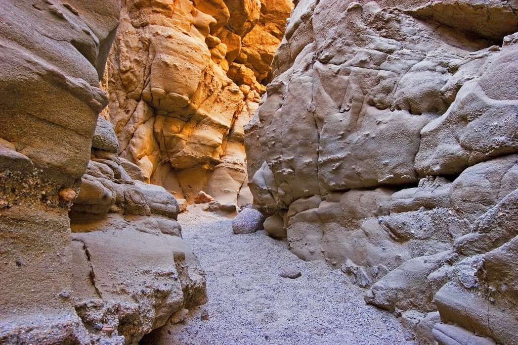
Next is the Truckhaven rocks stop at Mile Marker 36. Here you will see big reddish-brown sandstone rocks in the distance. These are some of the oldest sedimentary rock formations in the park and they are 4 to 5 million years old.
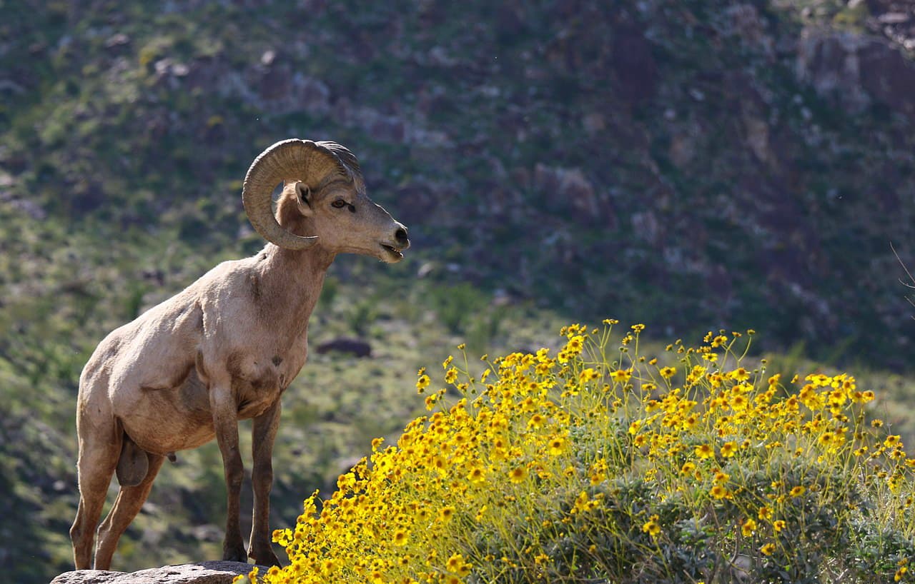
At the base of Truckhaven rocks are steep walled gorges and slot canyons. This area is also the boundary between Anza-Borrego and the Santa Rosa and San Jacinto Mountains National Monument. This area is also an important habitat zone for the peninsular desert bighorn sheep, mountain lions, and a variety of other plants and animals.
As you continue from here and head east you will notice how the flat land around you is carved into finger formations. These are called barrancas. You can also see desert pavement, which is a mosaic of pebbles, cobbles, and boulders on top of the fingers.
Your last stop is the Calcite Mine Scenic Overlook at Mile Marker 38. The original road in this section was built by General Patton’s troops during WWII. This was the top producing calcite mine in North America at one time.
The calcite from this mine served to help in the production of calcium carbonate, which were used in optical ring sights for the military’s gunners and torpedo bombers. Today, however, you will find a honeycomb of calcite veins and a ton of empty pockets where the calcite was extracted.
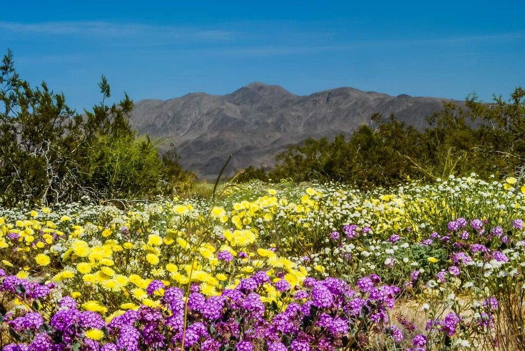
Anza-Borrego Desert State Park is known for being very hot, with average high temperatures in the summer months regularly reaching 107ºF (41.7ºC). In fact, the record high in the region is an astonishing 122ºF (50ºC). Additionally, Anza-Borrego receives an average of just 5.84 in (14.7 cm) of rainfall each year, so only the heartiest of plants and animals can survive in this landscape.
The park contains flora and fauna that are mostly within the Colorado Desert ecosystem of the Sonoran Desert ecoregion. However, in the northern and easternmost sections of the park, there are some California montane chaparral and woodlands ecoregions, particularly near the Santa Rosa Wilderness and Santa Rosa and San Jacinto Mountain National Monuments. Much of Anza-Borrego is dominated by badlands and desert washes.
However, it is important to remember that the desert landscape of Anza-Borrego, while seemingly barren, is not without biological diversity. The park can often look lush in places like the San Felipe Wash, where the water table is closer to the surface. This is also true in the rugged and rocky high desert of the Culp Valley and in the eastern parts of the park towards the Salton Sea.
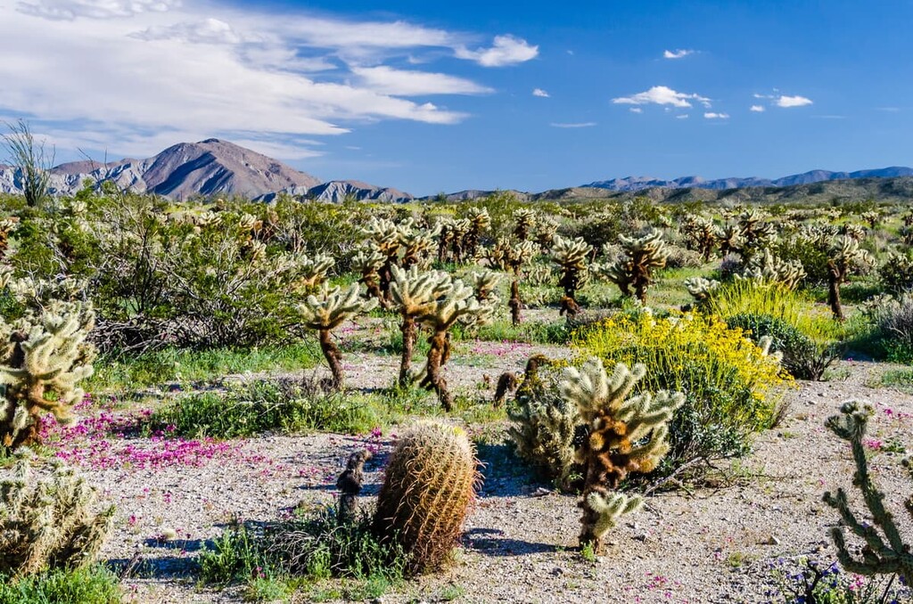
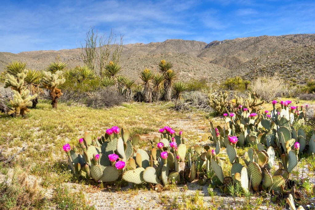
There are a number of desert plant characteristics to look out for in Anza Borrego, but the most readily apparent characteristic is that (not surprisingly), most plants have spikes and thorns. These spikes and thorns exist for two reasons: to deter hungry animals from nibbling on a plant and to provide shade to the plant itself. In fact, spikes and thorns used to be leaves. They shrank and evolved over millennia to become the deterrent they are today.
Cacti like the catclaw have curved spines (like a cat’s claw), and ocotillo have thick wicked spines. Cacti like the barrel cactus have large spines that cover almost the entire plant, while others like the Beavertail cactus have such tiny spines that you need a magnifying glass to see them.
Meanwhile, barrel cacti can hold up to 90% of its weight in water, which contributes to its name (these plants fill up like barrels and have a similar shape). This method of storage helps Barrel Cacti survive the often extended dry season.
The barrel cactus does have one foe however, the peninsular desert bighorn sheep, which sometimes eat them. With their horns, the sheep break open the top of the cactus and eat the juicy flesh.
Another interesting fact about the Barrel cactus is that they are not good water sources in the desert. That’s because water becomes highly alkaline when it is housed in the cactus. In fact, you might become thirstier after drinking from a barrel cactus.
Hedgehog cacti (also known as calico cacti), grow to about a foot in height and have multi-colored spines. This cactus has beautiful, showy, purplish-red flowers in the late spring.
The fishhook cactus can also be found in the park and is characterized by its red-tipped hooked spines. The fishhook cactus grows best in rocky areas and relies on tiny solitary bees for pollination of its flowers in the late spring. After pollination this cactus bursts forth with long, bright, tubular fruit.
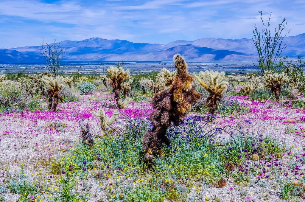
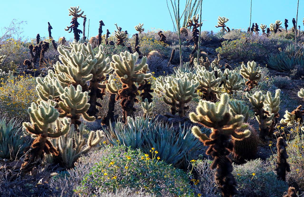
Jumping cholla (also known as teddy bear cholla) is another expansive resident of the desert. So named for their method of reproduction, the jumping cholla is known for popping its newly formed spiky pods on the ground around it so that they can take root and grow.
Often these segments hitchhike on unsuspecting wildlife or hikers to be transported and deposited further away. Hikers should take care as the spines are very painful and hard to remove if they get in your skin.
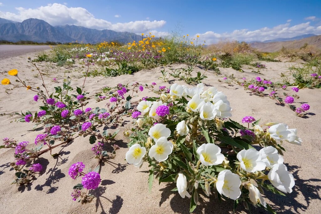
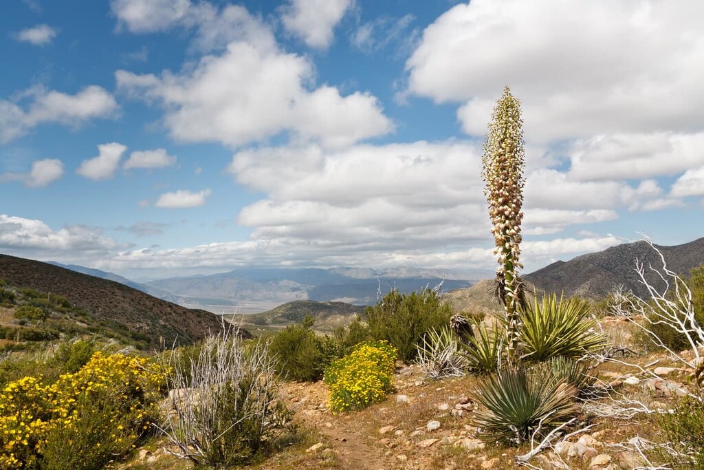
More famously, Anza-Borego is home to large fields of yellow-blooming spiny agave, which can especially be found along the Great Southern Overland Stagecoach Route (S2) headed south towards Agua Caliente. Agua Caliente is a seasonal county park whose main draw is it's hot and warm springs, camping, and short hiking trails.
Traditionally, agave was a major food source for the Kumeyaay people. Leaves, blossoms, and seeds were eaten, but it was the agave’s flowering stalk that was the real treat.
Agave only bloom once in their lifetimes, at the age of about 75 years old. A large stalk shoots up from the base and can grow several inches a day. The young tender stalks would be harvested and roasted in special pits. The fibers of the agave were also used to make bow strings, brushes, shoes, and snares.
Anza Borego is also home to towering, spiny, red-blooming ocotillo, whose branches reach out towards the sky waiting for the next rain to come. These semi-succulent, desert plants are, interestingly enough, more closely related to tea and blueberries than to cactuses.
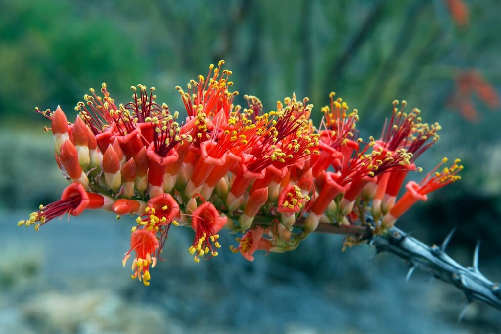
The ocotillo have shallow root systems that spread wide and soak up every drop of rain that soaks into the ground. After seasonal rains, new leaves quickly sprout, grow, and then store newly acquired, and much needed water and nutrients. Hummingbirds are incredibly dependent on ocotillos for their survival. You can often find hummingbird nests among the ocotillos red flowers.
Another friend to the hummingbird is the red-flowered chuparosa, which is dormant most of the year and drops its leaves during the driest months to conserve water and energy. In the spring, however, when the chuparosas are in bloom, hummingbirds will seek out the flower’s long tubular red blossoms.
Brittlebrush can also be found in the park and is distinguished by its powdery white leaves. If you look at the leaves closely you will see insulating hairs that provide shade for the leaves and the brittlebush as a whole. During the dry season there are many hairs on the leaves, but during the wet season they are sparser.
The brittlebush is a member of the sunflower family and blooms bright yellow flowers in the spring. In the summer, the flowers shrivel up and fall off and the stems dry out and become brittle, giving the plant its name.
The park is also home to saltbrush, a woody evergreen shrub with gray leaves and stems. Saltbrush is so named for its ability to grow in salty soil systems because it can pass the salt through its system and out onto tiny hairs on the surface of its leaves.
These hairs eventually die from over salinification and then leave salt crystals behind, which then provide shade for younger leaves to come in and start the process all over again. Cowboys would call saltbush cattle spinach because even during the dry years when there was little grass for the cows to eat, they could still eat saltbush.
Creosote bush is the most common resident of Anza-Borrego. The shrub is characterised by tiny, dark green, shiny leaves and in the spring creosote bush blooms tiny yellow flowers that turn into fuzzy seed balls that break apart and blow away in the famously high California desert winds.
Over the centuries, the ancestors of the Kumeyaay developed dozens of medicines from the creosote bush including tonics that cured colds, healed wounds, prevented infections, relieved pain, and even got rid of dandruff!
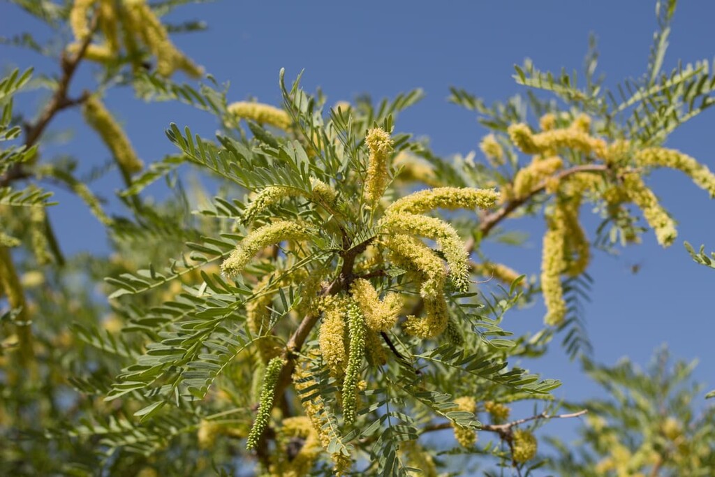
Yet another well adapted floral resident of Anza-Borgeo is the honey mesquite tree. These trees host yellow blooms in the spring and long skinny seed pods in the early summer. As the name would suggest, the wood from these trees are used in preparing mesquite smoked chicken or beef.
For the Kumeyaay people, these trees were an incredibly important food source as they would grind parched seed pods from the tree to make flour for cakes and cereals. The trees also offered different ways to make a wide variety of foods, beverages, clothing, tools, medicines, and more.
Another plant to look out for is the catclaw shrub and its parasitic guest, the desert mistletoe. Desert mistletoe is notable for not just growing on plants like the catclaw shrub, honey mesquite, or ironwood, but actually into the plants as well. You can identify these parasitic plants by its bunches of red, yet nearly transparent berry.
Like much of California, Anza-Borrego has not been spared its fair share of invasive species. One example is the tamarisk tree. These trees actually come from the Middle East and were planted at the Tamaris Athel Campground in the 1930s when the campground was a prison camp for San Diego County inmates.
The tamarisk tree has mostly sterile seeds and spreads by roots or stump sprouts. While these trees are great for shade, they are more than a little greedy when it comes to water consumption, which can pose a real problem for the park’s native inhabitants. The tamarisk tree’s deep reaching roots can drink up to 200 gallons of water a day.
Another invader is the second species of tamarisk, Tamarix ramosissima, also known as a salt cedar. This shrub has an insatiable thirst and can spread quickly while absorbing so much moisture that the water table actually lowers. This not only kills the native plants that are unfortunately enough to be in its path, but the salt cedar eventually grows so densely that wildlife cannot even penetrate through it.
While Anza-Borrego is famous for its surprisingly diverse plant population, fauna have to work much harder to survive in the park.
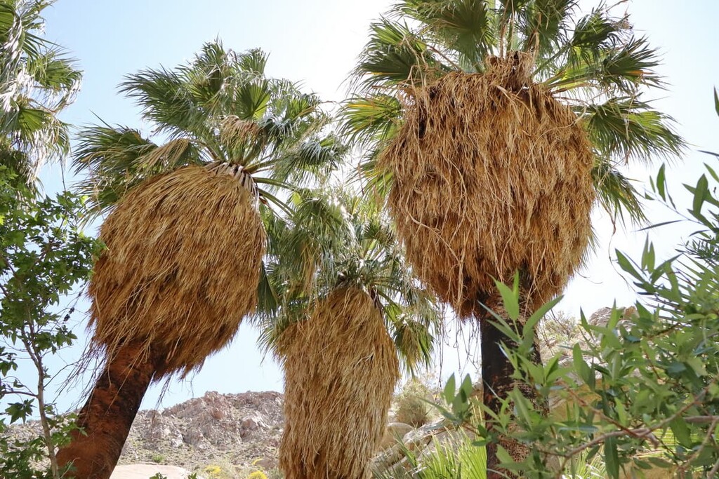
However, Anza-Borrego is known for having a handful of natural springs, which support a number of oases within the park. These oases feature California fan palm (Washingtonia filifera), the only native palm tree in the state of California.
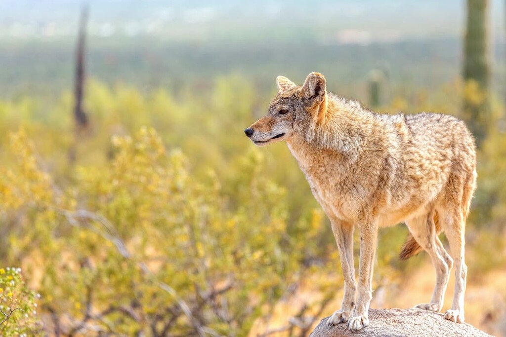
Oases are also some of the best places within the park to see wildlife, especially mountain lions, kit foxes, coyotes, mule deer, black-tailed jackrabbits, golden eagles, and greater roadrunners.
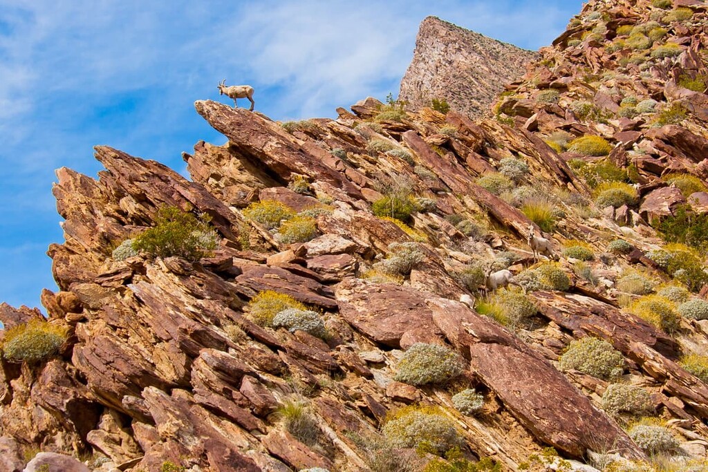
The various oases of the region are a particular draw from Anza-Borego’s peninsular desert bighorn sheep population, which is a subspecies of bighorn sheep that is endemic to the area. These desert bighorn sheep are sometimes spotted in the Culp Valley area in the high desert of the park, or around Agua Caliente spring, both areas of which are home to the two major desert bighorn sheep populations.
The park is also home to northern phainopepla, which feast on the berries of the desert mistletoe. If the bird drops seeds on the branch of a mesquite, catclaw, or ironwood, the desert mistletoe has found its new host.
Male phainopepla have glossy black bodies and a crest. They also have white patches on their wings that can only be seen when they are in flight. Females are grey with pale wing patches. These birds can be identified by their single “wurp” call.
Anza-Borrego Desert State Park is part of the ancestral homelands of a number of Indigenous peoples, including the Cahuilla, Kumeyaay, and Cupeño, among countless others. Indigenous communities have lived in the region for thousands of years. The park contains a sizable number of petroglyphs, as well as other archaeological remains.
The Kumeyaay people were traditionally the most dominant group in what is now the Anza-Borrego desert. As a result, remnants of the community’s seasonal camps can be found all over the park. It is not uncommon to find pottery shards, bits of charcoal, and flakes of obsidian. Guests are asked to leave artifacts alone and contact park staff if they find any.
Anza-Borrego’s name comes from a combination of borrego (English: sheep/lamb) and the last name of Juan Bautista de Anza, a Spanish military officer and the one-time governor of Spanish New Mexico.
In the late 1800s, the area that is now Anza-Borrego was a cowboy paradise. Yaqui Well was a source of support and provided both water and ready foraging to regional cowboys and their cattle.
In 1972, John McCain, a former stagecoach driver with the Butterfield line, built a road from the Scissor Crossing area east over the hill through Plum Canyon and finally into Yaqui Springs. In 1909, Paul Sentenac, a French-American, built a cabin in the area and a string of watering troughs. This now back to nature hiking area used to be filled as far as the eye could see with cattle.
The park itself was first established in 1933, making it among the earliest of the California state parks that are still in existence today. It contains a number of wilderness areas, including Anza-Borrego Desert State Wilderness, Coyote Mountains Wilderness Area, Fish Creek Mountains Wilderness Area.
Anza-Borrego State Park also works closely with the Anza-Borrego Foundation (ABF), a non-profit and cooperating association, which manages the park’s stores and visitors centers. Its educational branch, the Anza-Borrego Institute, also provides educational courses to students and adults to help protect and preserve the park’s natural landscape and cultural heritage.
The Pacific Crest Trail, one of the USA’s premier long-distance hiking trails, also passes through the park. Anza-Borrego is the first major section that northbound PCT hikers walk through on their way from Mexico to Canada, which is one of the driest parts of the trail.
The best part about camping in Anza-Borrego is that there are a number of dispersed camping sites throughout the entire area. They are not only free, but most of them also have pit toilets available. These include:
All of these campsites, except Yaquis Pass, have pit toilets. However, if you want a few more amenities you can also go to one of the park's developed campgrounds (for a fee). These include:
California deserts are famous for two reasons, the wind and the heat and while Anza-Borrego is by no means the most intense of the California deserts, it is not without its challenges.
It is not uncommon for winds to be 30 to 50 mph (13.4 to 22 m/s) and for temperatures to stay well above 100ºF (38ºC). As such, you need to dress to protect yourself from the wind and the sun and bring much more water than you would plan for otherwise. Wear long sleeves and a hat and start your hikes early in the day. A good rule for hiking in Anza-Borrego is that once you have gone through half your water, you need to start heading back to the trailhead.
Anza-Borrego is a veritable choose your own adventure destination when it comes to hiking trails. Here are a few of the best options to check out:
There are a number of trails around the Anza-Borrego Visitors Center that are more accessible for families and the more beginner hiker. These include the Campground Trail and the Palm Canyon Trail.
As the name suggests, the Campground Trail leads to one of the two paid campgrounds in the park and connects to a Panoramic Overlook trail. In and out, this trail is 2.4 miles (3.9 km).
The Borrego Palm Canyon Trail leaves from the campground and is an approximately 3 mile (4.8 km) round trip hike up the canyon to a native palm grove. It passes by at least one seasonal waterfall. It should be noted, however, that the palm grove may be closed for restoration.
If you are staying at the Culp Valley Dispersed Camping campground then do yourself a favor and go for a morning hike through the Culp Valley.
You can opt for the shorter hike (about 0.5 mi/800 m) to the nearby overlook that gazes out onto the Borrego Spring Valley. Or you can continue through the Culp Valley and hike down past Pena Springs to a lower overlook in the middle of the valley. This hike will give you spectacular views of the high desert mountain ranges, as well as the Borrego Springs Valley.
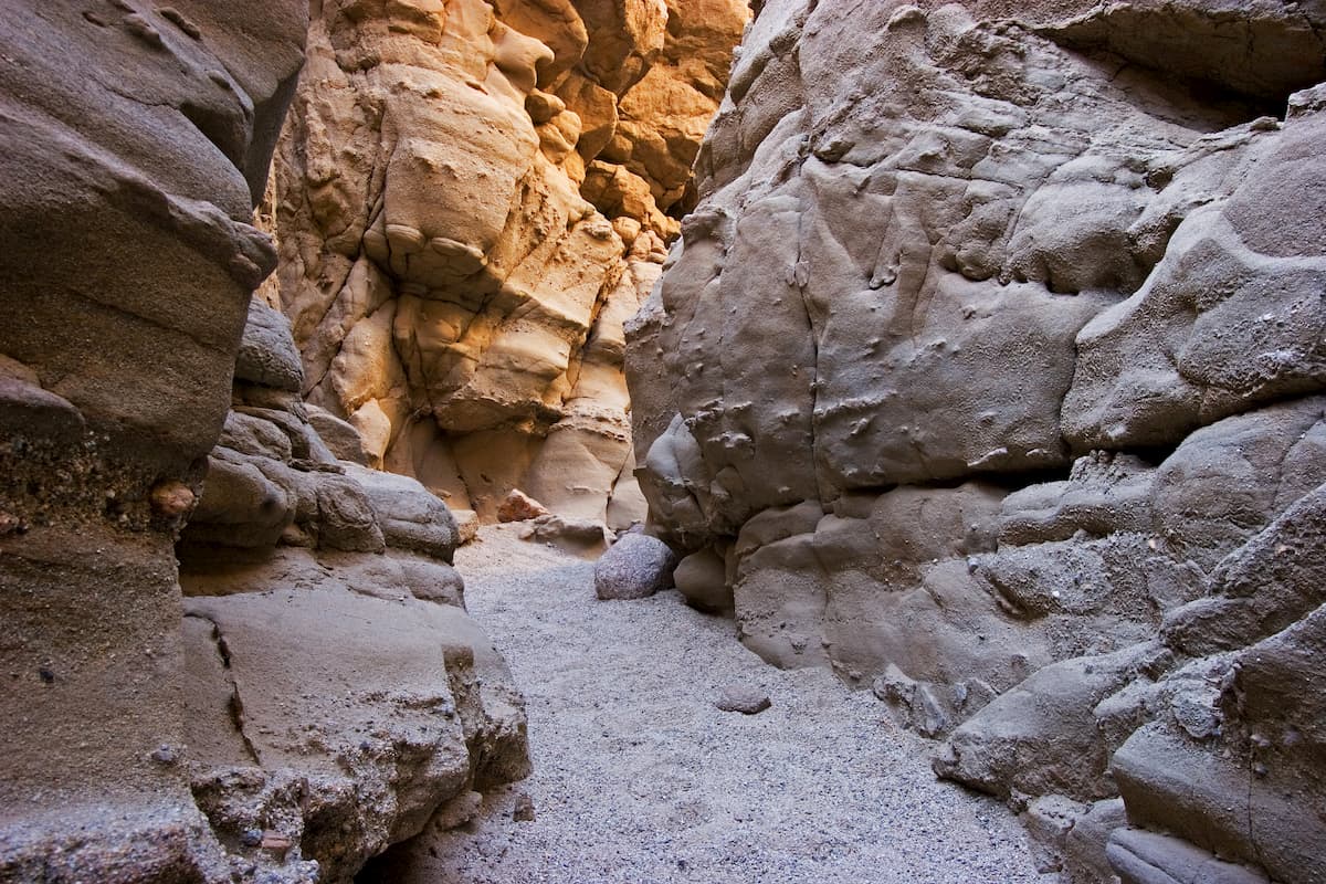
The Slot is a cool 2.3 mile (3.7 km) hike through one of Anza-Borrego’s slot canyons. It is partially shaded and offers some fun scrambling for the more adventurous among us. To get there you drive east on Palm Canyon Road (S22) to Christmas Circle.
Turn right on Borrego Springs Road and drive 12 miles (19 km) to Highway 78. Turn left on Highway 78 and continue for 1.4 miles (2.3 km) to Buttes Pass Road. Then turn left to the Slot Parking Lot where you will follow signs for the trail.
The trail to Hellhole Canyon and Maidenhair Falls is 4.9 miles (7.9 km) long in and out and involves a small amount of climbing over small boulders as you make your way to a natural palm oasis.
There are also two waterfalls along the way (during the winter and spring, that is), which make for a nice reprieve from the desert heat. You can also take a side detour at the beginning (or end) of the trail to Little Surprise Canyon. It is only a 0.4 mile (640 m) detour, but it offers great views in wildflower season.
This trail can be started at either the visitors center, for an additional 1 mile (1.6 km) of hiking each way or at the Hellhole Canyon Trailhead just up the road on the way to the Culp Valley.
It also intersects with the hiking and riding trail coming down from the Culp Valley. The hiking and riding trail heads up to the Culp Valley dispersed camping site before continuing deeper into the park and is a great way to try and catch a glimpse of the resident desert bighorn sheep.
If you want a relatively short adventure in Anza-Borrego Desert State Park, there are plenty of great hiking trails to choose from. Here are some of the best short hikes to consider in the park:
Here are some of the best places to stay before or after your trip into Anza-Borrego Desert State Park:
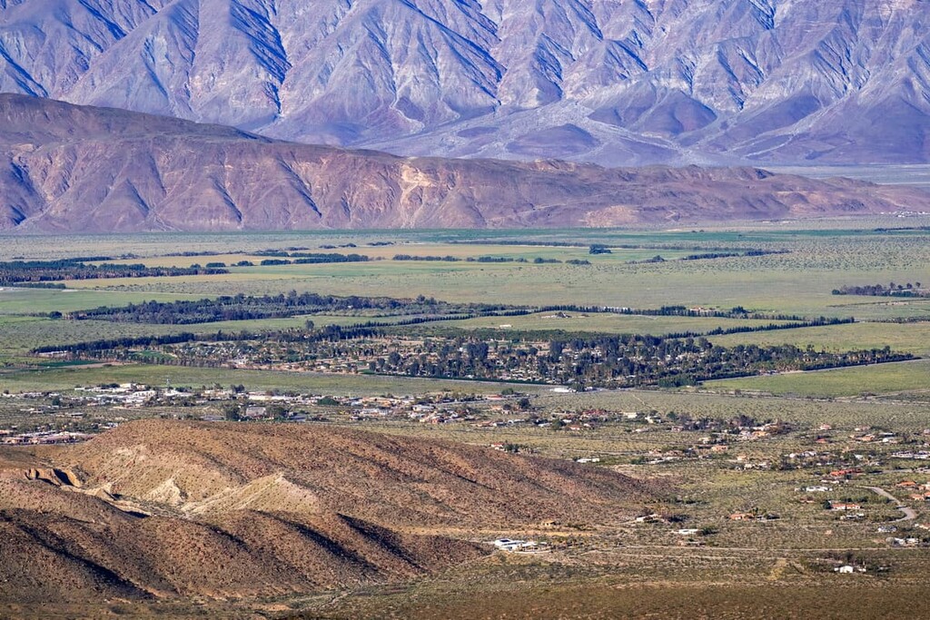
The town of Borrego Springs is located in the northern section of Anza-Borrego Desert State Park, providing some of the best access to the park’s trails. Borrego Springs is completely surrounded by the park and has a population of about 3,500 people.
Interestingly, there are no stoplights within the town and nighttime light is kept as low as possible to help protect the local views of the night sky. The town is considered an International Dark Sky Community for its expansive views of the starry sky.
Travel to and from Borrego Springs is mostly by car. The city of San Diego is just a two hour drive west from the town while Palm Springs is a one and a half hour drive north.
While not technically a town, Agua Caliente is a seasonal county park that offers a great alternative to staying in the park. Open only during the cooler parts of the year, and closing for around 2 to 3 months in June, Agua Caliente’s biggest draw is the natural hot and warm springs that erupt from its canyons.
Visitors can stay at local campgrounds and bathe in the spring pools, as well as hike up the canyon to check out where the hot springs begin and even catch a glimpse of desert bighorn sheep that live near there, or the native California stream orchid along the streambeds! There is also a small general store at the entrance of the park for the basics.
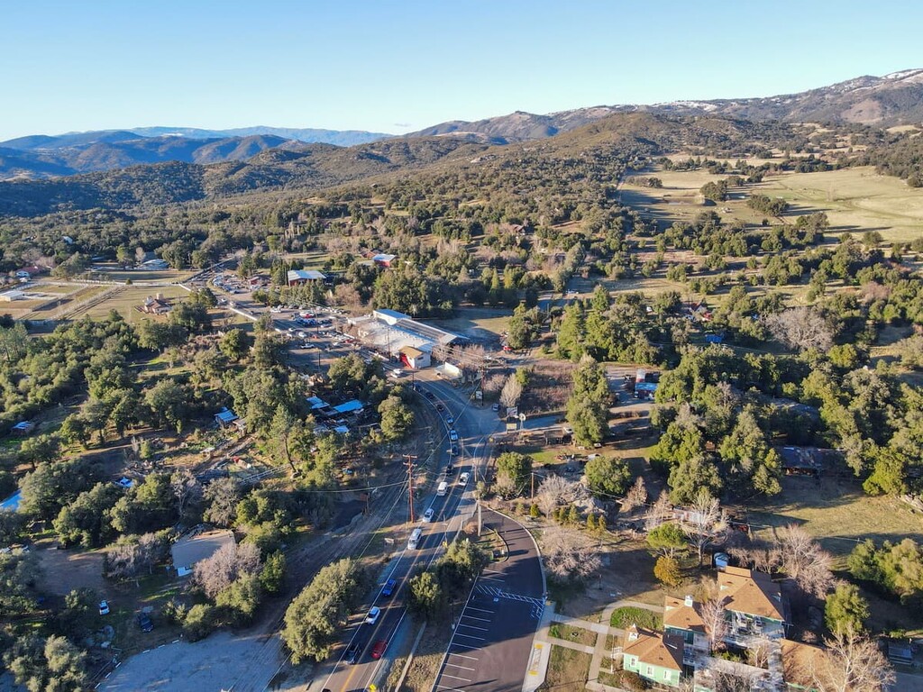
If you are wanting to explore Anza-Borrego State Park, but you want some of the comforts of home (and maybe even some reprieve from the desert heat and wind), Julian is your best bet.
This small gold mining turned tourist town is a major byway for Pacific Crest Trail hikers. It even has dozens of restaurants, breweries, cider mills, wineries, antique and craft markets, bed and breakfasts, and hotels to keep you comfortable and entertained.
San Diego is situated to the west of Anza-Borrego Desert State Park along the United States’ border with Mexico. It is the second largest city in California with 1.4 million residents.
San Diego is a major transportation hub, with great road, rail, and air connections. It also offers quick transport links to Mexico’s Tijuana Airport through the Cross Border Xpress.


desert-summits-book
sierra-club-100
100-peaks-section-emblem
sierra-club-desert
desert-summits-book
sierra-club-100
100-peaks-section-emblem
sierra-club-desert


