Scan the QR code and open PeakVisor on your phone
San Diego County is located in the southwestern corner of the state of California, which has 58 counties. It has an area of 4,204 square miles which is almost the size of the state of Connecticut – yet there are eight larger counties in California. As of the 2020 census, its population was 3,298,634, making it the second-most populous county in the state and the fifth-most populous in the entire United States. The county seat is the city of San Diego with a population of 1,386,932, the second in population in California and eighth in the United States. The county also has 18 federally recognized Indian reservations – they are all small with a combined population of just over 5,000. The county shares borders with three other counties (Orange, Riverside and Imperial) as well as the country of Mexico. On the west is the Pacific Ocean.
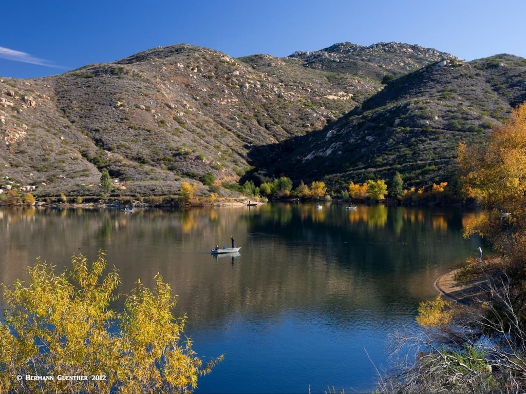
So with such a large urban character, why are we writing about it on PeakVisor, which, after all, is all about mountains? Well, here is why. San Diego County has 259 named mountains - the highest is Hot Springs Mountain and the most prominent is Palomar Mountain High Point. With most of the population concentrated along the coast in a corridor about 15 miles wide, this leaves lots of land with a very low population density. This land is ideal for recreation. There are three National Protected Areas including Cleveland National Forest; seven official wilderness areas; 17 state parks and state-protected areas; nine mountain sub-ranges; more than 25 lakes and reservoirs; and seven rivers (though some of them dry out at certain times of the year).
Elevations in San Diego County range from sea level to a high of 6,535 feet at Hot Springs Mountain. Some websites claim, probably incorrectly, that the lowest elevation in the county is 236 feet below sea level, which is the average surface elevation of the Salton Sea in the Imperial Valley less than three miles from the nearest point in the county (which is above sea level). With such variations in elevation and the proximity of both the ocean and the inland deserts, it is no surprise that the county experiences a wide range of climate conditions. A Mediterranean climate dominates the populated areas while the eastern and southern parts have a semi-arid desert climate. The mountains are generally between these, trending from northwest to southeast and experience the highest rainfall amounts (and unbeknownst to many people, significant snowfall in the winter months).
Though not widely recognized as a major hiking destination, San Diego County offers amazing opportunities for recreation, and that includes no shortage of hiking trails. But we must keep in mind that high alpine mountain-climbing experiences are not to be found in this county. For that, visitors must head for the higher elevations of the Sierra Nevada Mountains and other northern California ranges. Nevertheless, there are hundreds of hiking venues in the county, including many within San Diego city limits, which get their fair share of visitors and even avid hikers. Just drive past the trailheads of such fine hiking areas as Iron Mountain or Woodson Mountain on a weekend and you shall see what I mean. Yet there are many places that my wife and I have discovered since moving into the county in the fall of 2021 that might not see more than one or two hikers all day, especially on weekdays, which is when we do all of our hiking. Although we are still on the trail of discovery, having only lived here six months, we have found a fine selection of hiking areas that are representative of the best that San Diego County has to offer. Let’s go exploring.
But before we go hiking, it is appropriate to point out just a few of the world-class sites visitors can take in while spending a vacation in San Diego County. There is the city of San Diego itself. One of our favorite activities is to just walk the waterfront right at the edge of downtown. And when you need to rest your feet and nourish your body, you can hang out in the charming Seaport Village which has dozens of fine restaurants and shops. You can walk to the nearby U.S.S. Midway museum and tour the decommissioned aircraft carrier of the same name. Here also are the cruise ship terminal and several port facilities at which you can book a variety of harbor cruises.
Take a short ferry ride across the harbor to Coronado Island. You can even drive across on the beautiful Coronado Bridge. The view of the city skyline from Coronado is breathtaking. You can even visit the famous historic Hotel del Coronado – more likely to be accommodations for celebrities than hikers. When you are back downtown, a visit to the beautiful Balboa Park is a must. A day is not nearly enough to visit this amazing place that features a number of museums, theaters, restaurants and various gardens. Located conveniently beside Balboa Park is the world-renowned San Diego Zoo.

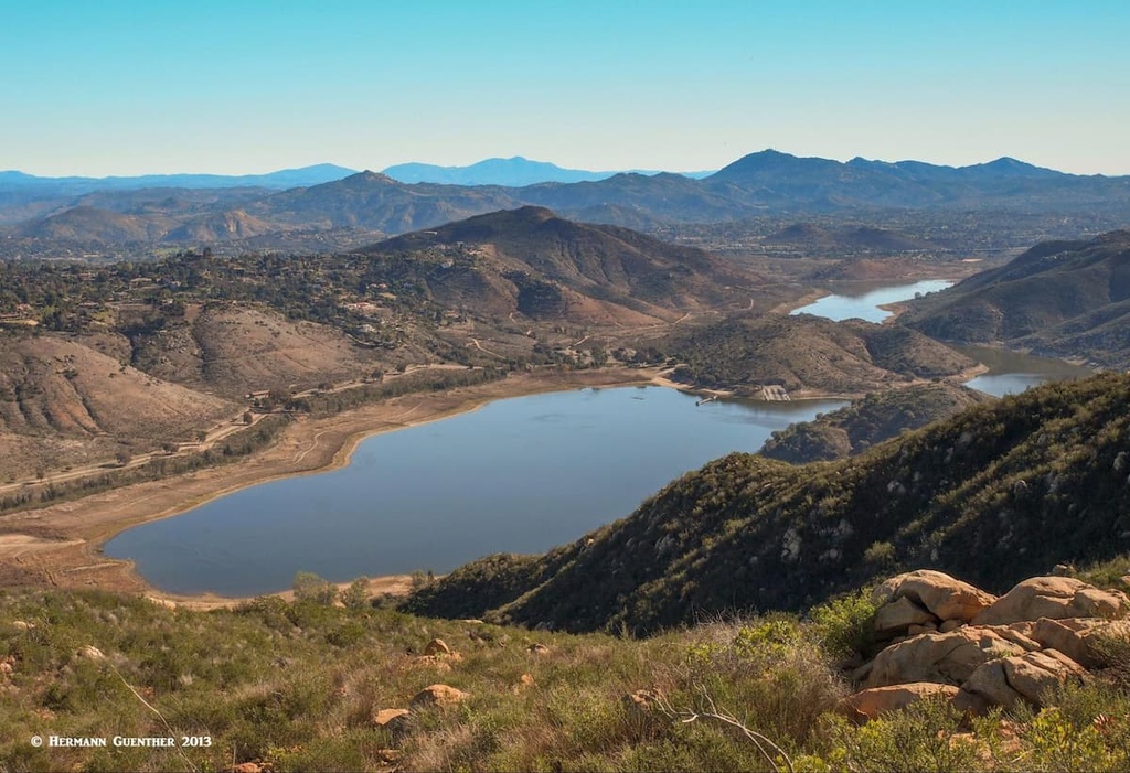
Outside of the city are a number of large lakes that are open for recreation. The San Vicente and El Capitan Reservoirs are popular attractions. In the mountains are such lakes as Lake Henshaw and the smaller Lake Cuyamaca. To keep the kids entertained, there is Legoland in Carlsbad and SeaWorld in Mission Bay; nearby are lots of places for running, biking, picnicking and hanging out on the beach. Further out of town, between Escondido and Ramona is the San Diego Zoo Safari Park, originally named the San Diego Wild Animal Park. This huge preserve in the beautiful San Pasqual Valley is one of the largest tourist attractions in San Diego County. And if wine tasting is your thing, you will be overwhelmed by the large number of vineyards and wineries throughout the county. So… cheers and enjoy.

With so many places to get some real hiking experience in San Diego County, it can be a daunting task to choose where to go from the great selection of venues available. I will therefore limit my discussion mostly to hikes that we have done, that I am very familiar with and that I consider worthy and representative of the best that the county has to offer. I will, however, suggest one or two that I have not done (and never will do) just to make this experience well-rounded by terrain types, climate considerations and popularity.
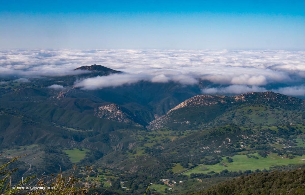
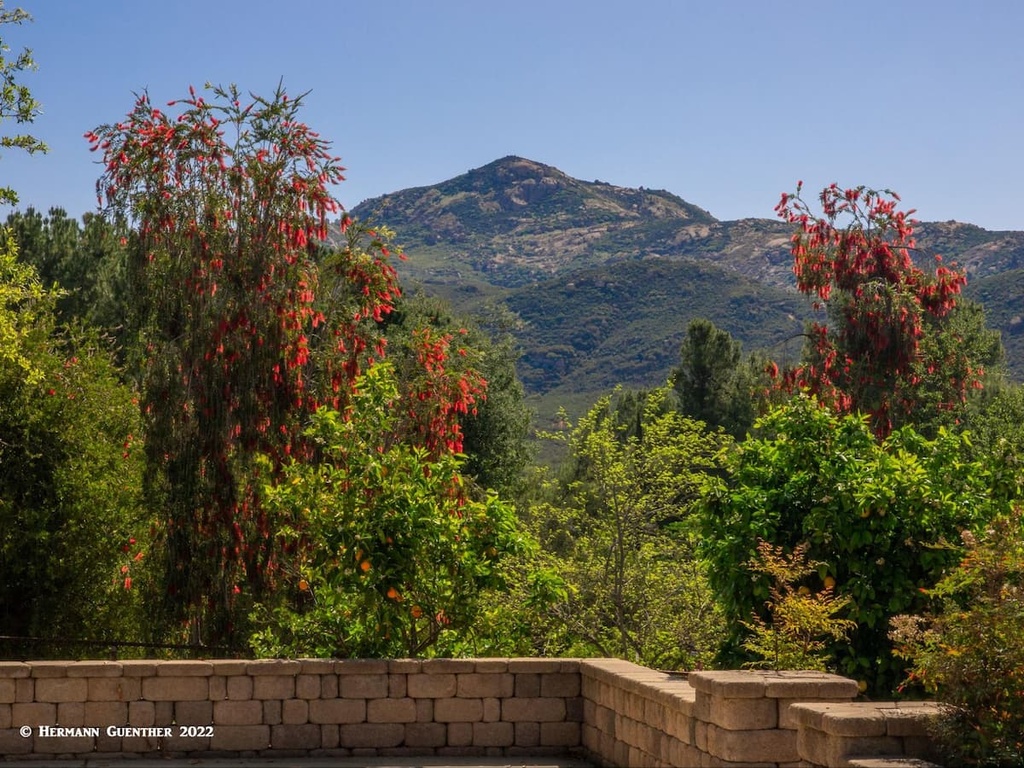
There are many hikes, short and long, in this magnificent park high in the mountains that run across the center of the county. There are two obvious benefits one realizes hiking here – it is considerably cooler at the high elevations and the views from the highest peaks extend from the Pacific Ocean to the desert to Mexico and as far as the mountains and off-shore islands not far from greater Los Angeles. In the winter months this place can get lots of snow – they measure it in feet here, not inches. I will tell you about two that we have done in the short time that we have lived in San Diego County.
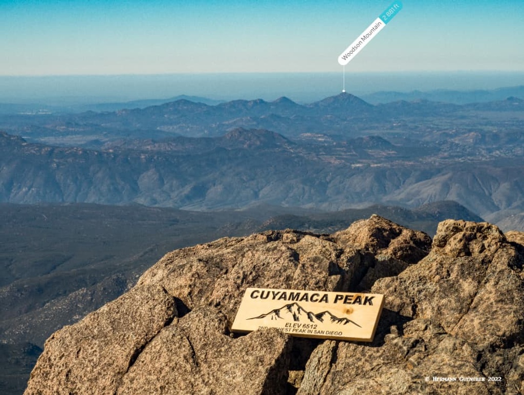
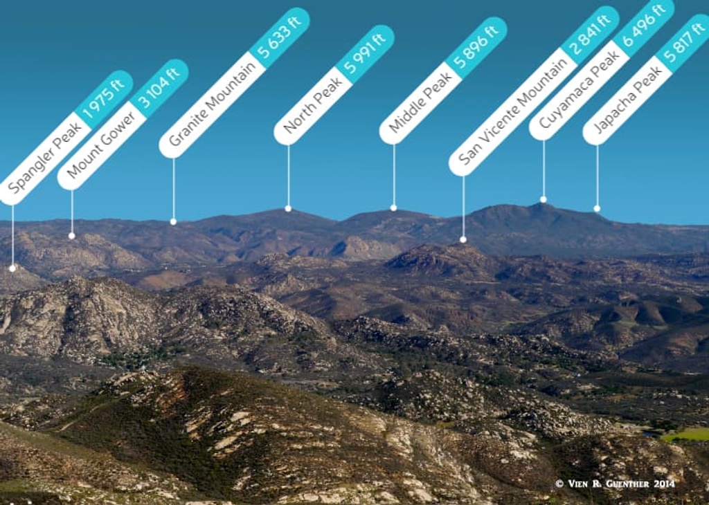
Cuyamaca Peak – At 6,512 feet high (based on the summit sign, although PeakVisor has it at 6,496 feet), Cuyamaca is the second-highest mountain in the county. Only Hot Springs Mountain at 6,526 is higher – the fact that it sits on an Indian Reservation and that a fee of $10 is required to hike it makes it less popular than its slightly lower brother (or sister). Yet it is reputed to be a fine hike, if somewhat strenuous, due to the amazing views from the top. But back to Cuyamaca; it offers some of the most stunning views we have yet seen in the county, no doubt due to its prominence. It is no wonder that the mountain can be seen from all over the county, including even from coastal trails. The most used trail is a narrow paved road (Lookout Road) which services a cluster of communications towers. But you won’t find any vehicles on the road as it is not open to private cars.
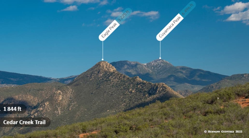
The trailhead is at the Paso Picacho Campground, from which you will have several options to climb the peak. We took a combination of trails starting with the Azalea Glen Trail-Azalea Spring Fire Road which then connects to the Conejos Trail. The latter then follows the north ridge of the mountain for a couple of miles before it crosses the Lookout Road. From this point we followed the road the short distance to the top – after a long lunch break and lots of photos of the views from the top, we hiked the road all the way back down. Because of the constant grade of the road, hiking up that way would be a real “leg burner” since every single step will be the same. Much easier to go the much longer distance and get lots of variety on the way up. By going down the road, you will get some fantastic views of Stonewall Peak to the east, beyond which you can see some of the higher peaks there as well such as the rugged Granite Mountain. We saw no other people on the trail going up or down, just a couple on the summit. We did encounter some snow and ice.
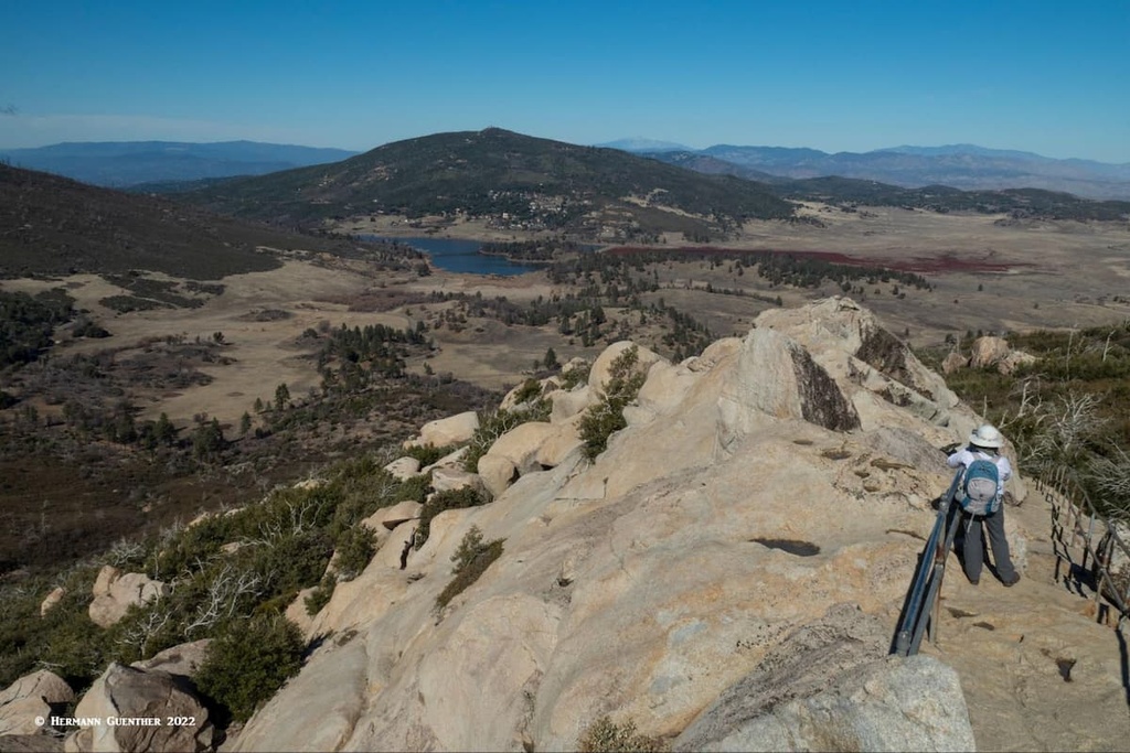
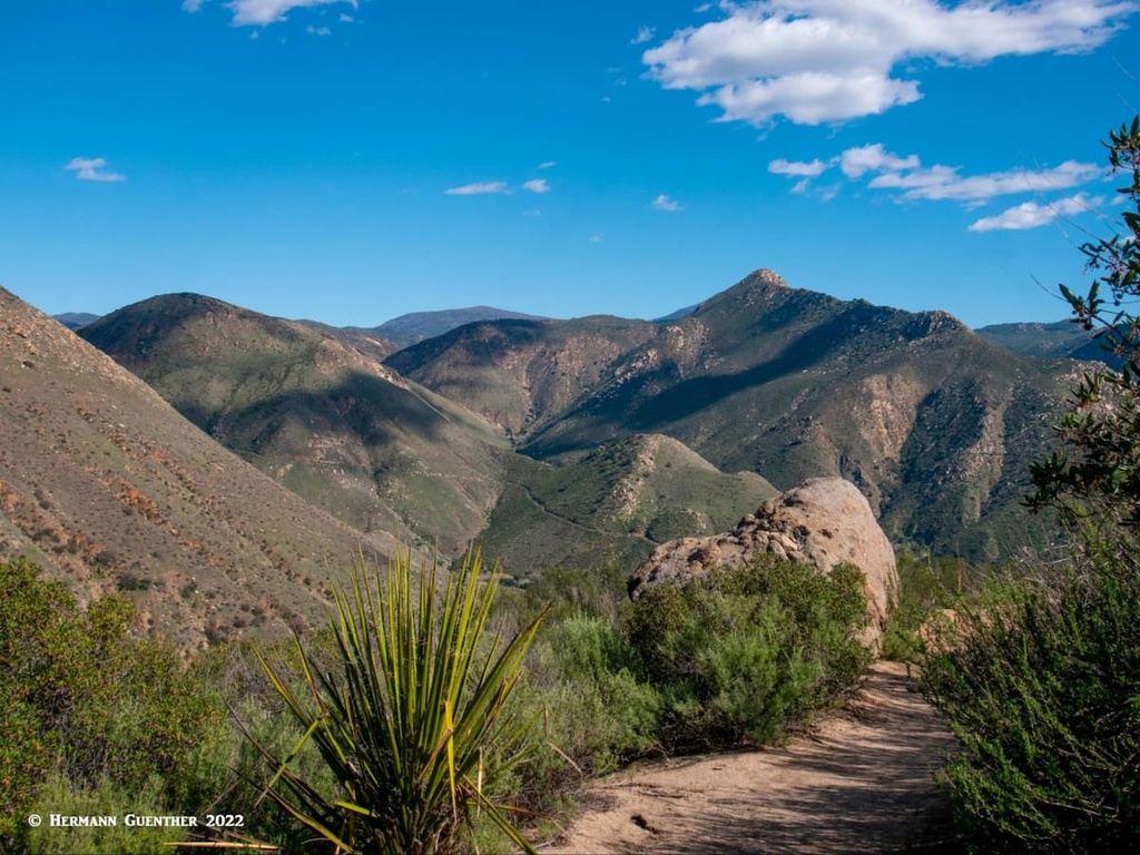
Stonewall Peak – This wonderful mountain is usually climbed from the same spot as Cuyamaca Peak – the Paso Picacho Campground. The majority of hikers will climb Stonewall by the traditional and shortest route, the Stonewall Peak Trail, which gently winds its way along the lower slopes. Then come the switchbacks, lots of them, but as a result no part of the trail is steep except at the very summit. This round trip hike is only four miles long. A more interesting route is to take the Cold Stream Trail from the trailhead and follow it northwards to its junction with the Vern Whitaker Trail to the point where it intersects the Stonewall Peak Trail at its northern end. Up to this point you will have gained no elevation – in fact you will have lost about 150 feet. Here is where the climb begins, rapidly gaining elevation while passing through very interesting terrain with progressively better views.
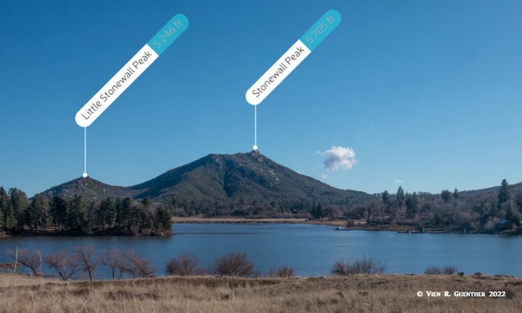
After passing over a saddle that connects Little Stonewall Peak with its parent namesake mountain you will climb towards your goal. As the trail climbs the summit cone on ever-shorter and steeper switchbacks, you will soon see the rocky summit. The final scramble to the peak is partly on steep ledges with steps carved out of the hard rock along the final pitch. The park administration had the good foresight to place a steel handrail for those who might feel just a little bit of acrophobia on this segment. Even with the handrail, this is not a good place for little children unless they are very closely supervised. The summit is tiny with only enough space for four or five people at one time. The handrail encloses this small space on all sides but on a windy day it might still be a bit unnerving to stand up there. Needless to say, the 360-degrees views from here are epic although the bulk of Cuyamaca Peak to the west will preclude any line of sight to the Pacific Ocean from here. We saw not one other hiker either on the trail to the top or at the top. But taking the more traditional trail back down, we did encounter a handful of hikers going up.
Poway is a city in San Diego County of about 50,000 residents just to the northeast of San Diego city. It calls itself “The City in the Country” presumably because of its one-time rural character. Truthfully, along its eastern periphery, its suburban appearance starts to diminish into a somewhat rural nature. This is where the town offers some really good hikes – and due to their proximity to a large population base (i.e. most of greater San Diego), they are extremely popular, especially on weekends. But these hikes are well worth it so we shall discuss two of them here.
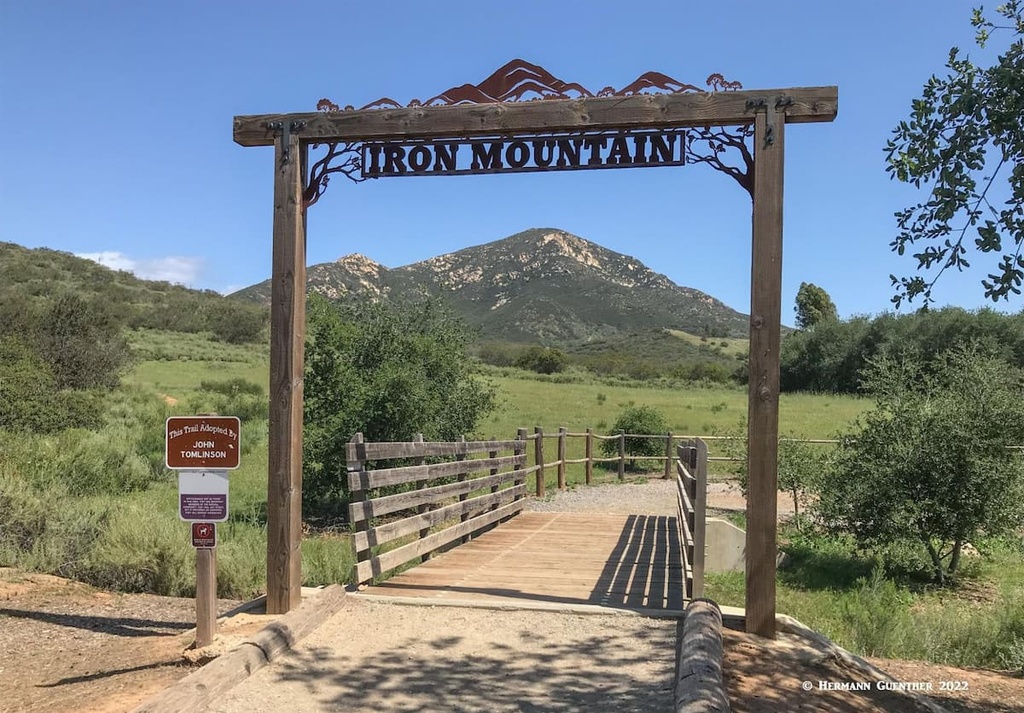
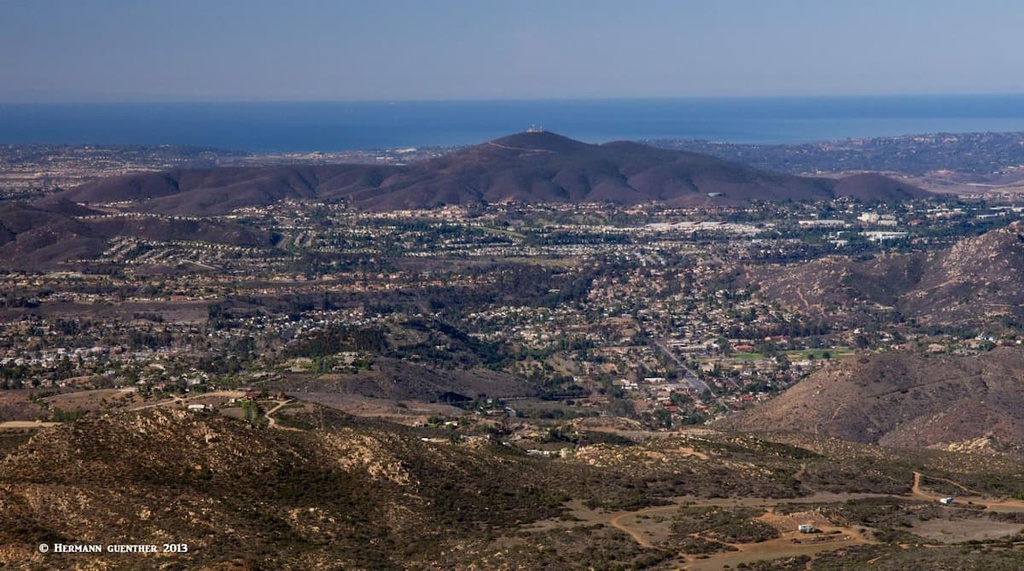
Iron Mountain – This very popular hike is easily accessible from major roads with the main trailhead parking lot often filled to capacity even early in the day, thus forcing lots of hikers to park along the edge of a busy road. This is not a desirable situation, but can be easily avoided by hiking on weekdays, which is what we always do. There are several route options though they all eventually involved the same final 1.5-mile segment to the summit. The main route most hikers take starts at the parking lot and heads straight east for 1.5 miles on a gentle grade to a trail junction. This is where a right turn puts you onto the summit segment that starts fairly level but then winds up on many switchbacks as it climbs the steep and prominent summit cone. This is truly an enjoyable morning hike since it can easily be completed in three hours or less with an overall distance of six miles and an elevation gain of 1,125 feet. The views from the top are great in all directions – 180 degrees of mountains to the east, and 180 degrees of urban sprawl to the west. On clear days the Pacific coast is easily discernible.
Let’s look at other, longer and more strenuous options that the great majority of hikers either don’t know about or don’t want to bother with. These options can be started from the same main trailhead or from a less-known trailhead only a mile north along the same highway. That one is known as the Ellie Lane Trailhead. These options can take the hiker into a vast network of trails into the backcountry; the main trail is named the Ellie Lane Trail. The remaining trails are all interconnected, and unmarked at the various junctions. But you can’t get lost because eventually you will either end up on Iron Mountain – or back where you started. These back routes are primitive, and in many cases, difficult. But this is my preferred hike to Iron Mountain. Instead of a six-mile hike, going this way adds up to three more miles to the hike and a lot more elevation gain – more than double the main trail. No matter which route you take, you will end up at the trail junction from which you then choose to climb to the summit. Along the way you can take a side spur to the Ramona Overlook, though this is not necessary since staying on the main trail will afford the same view. You will rarely see another hiker here.
Woodson Mountain– At first sight Woodson Mountain may not seem like an attractive hiking destination with such a large complex of communications towers on its summit, but just give it a chance. I have – many times. It is indeed a very fine hike, especially if taken from the west trailhead at the Lake Poway Recreation Area. (The east approach is much shorter and has less than half the elevation gain, but the “trail” to the top is actually a paved road although closed to private vehicles.) We have only hiked Woodson Mountain from Lake Poway – from here the round-trip hike is eight miles with an elevation gain of just over 2,000 feet. It is variably rated as moderate to “extremely” challenging. I would call it a moderate hike, trending towards “tough” if you also include a full circuit of Lake Poway as part of your hike, which I highly recommend, although this adds some additional elevation gain since the trail drops well below the lake elevation where it goes below and around the dam. There is a parking fee for non-residents on weekends and holidays only.
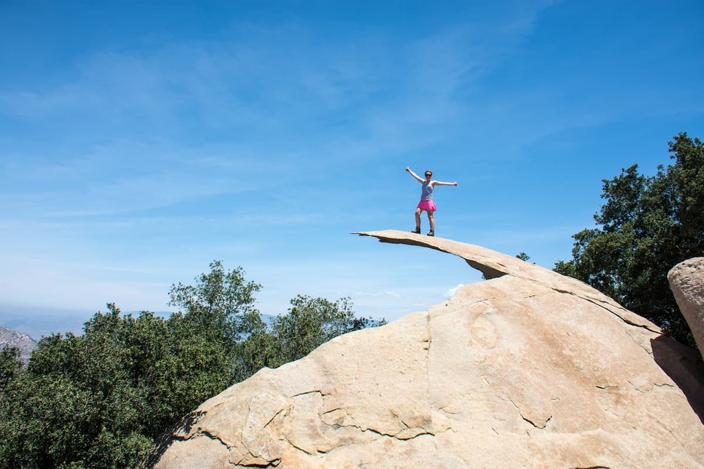
In recent years Woodson Mountain has become fashionable because of one unique feature near the summit – Potato Chip Rock. This thin slab of rock extends out into thin air from its anchorage into bedrock. This, of course, is popular because people will line up for an opportunity to be photographed sitting or standing at the extreme end of the overhang. I have seen as many as eight people defying gravity here. It is not unusual for 50 or more people (as many as 100 on weekends) to stand in line for their turn at a photograph. It’s a bit of a scramble to get onto and off the rock, thus adding to the waiting time. When I first climbed Woodson Mountain about 15 years ago, this “sport” had not yet caught on. I suspect that lots of these people go up the easy way, by the road on the east approach. That would explain why long lines of cars are always parked on weekends on the shoulder of the busy highway passing by here. They are not going primarily for the hike. It’s Potato Chip Rock they want! How long it will last until it collapses under the weight of all those people on it is anybody’s guess.
About 15 miles northeast of Poway is Ramona, a smaller community mostly surrounded by mountains though it sits in a wide, high valley that is known for its fine climate and easy access to recreation. I must mention that, being so far inland from the ocean (25 miles), it can get really hot here – even in spring and fall, not to mention summer. But these are surely some wonderful places to go hiking, though winter is perhaps the best season for this. We live in a mountain valley about five miles from the center of the town. We can even go hiking right from our doorstep. Following are a couple of “must-do” hikes in this lovely area.
Mount Gower Open Space Preserve – This great wilderness area abuts the northeastern edge of the San Diego Country Estates community. A nine-mile round-trip hike from the trailhead involves an “official” elevation gain of 2,178 feet, although the actual gain is several hundred feet higher due to many significant ups and downs along the trail. It is considered one of the most difficult hikes in San Diego County, but it is so worth the effort. The views are amazing and there are some magnificent rock formations at a small plateau just below the summit. Perhaps the best thing about this hike is that hardly anyone does it. When we did this hike in early December we encountered only two people at the top – nobody on the trail either coming or going. One word of caution – this preserve is closed the entire month of August due to extreme heat.
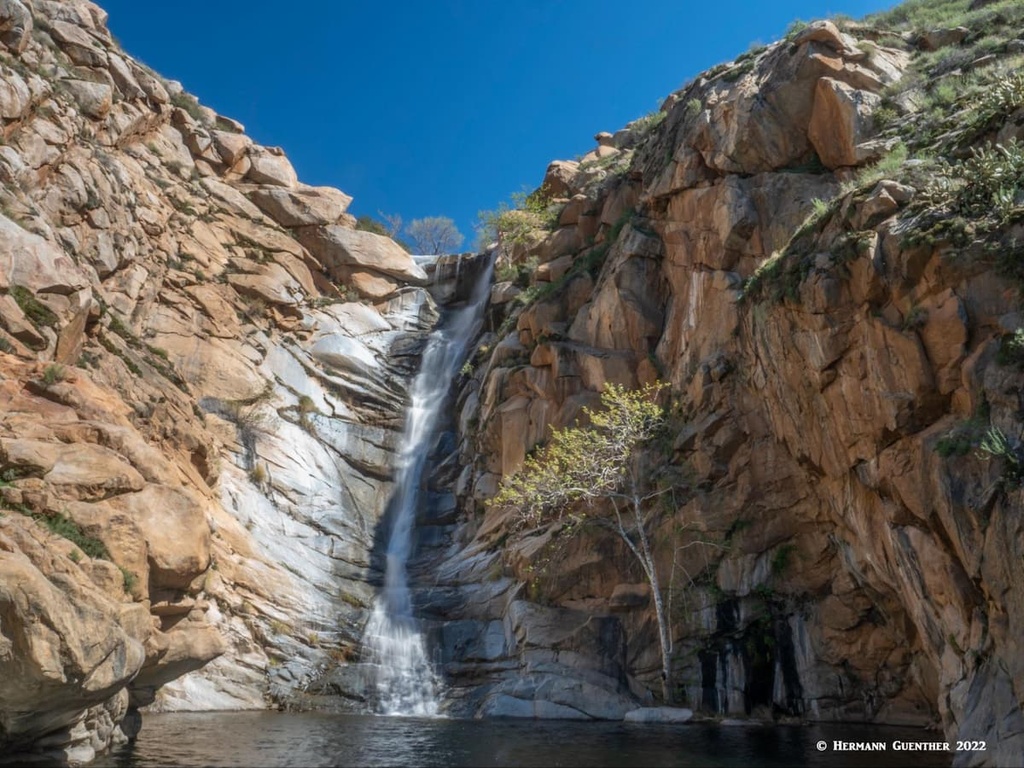
Cedar Creek Falls Trail – This stunning trail also starts right at the edge of the San Diego Country Estates, about five miles by road from the Mount Gower Trailhead. The hike to the waterfall is three miles – downhill, with an elevation drop of almost 1,200 feet. Several websites classify this hike as difficult for the simple reason that coming back up can be brutal when the weather is hot (and for people who attempt this hike totally unprepared). There are lots of warnings at the trailhead and along the trail advising visitors about the need to carry plenty of water. But we have seen people on the trail without any. Hikers have succumbed (read died) as a result of heat stroke on this trail. Many people have had to be rescued by helicopter as there are no roads down there.
While the waterfall is dry during parts of the year, especially summer, after a good period of rain it is simply spectacular. It is considered one of the finest waterfalls in southern California. But that is not the only attraction of this hike. The scenery as you go down is simply delightful. With all the many twists and turns of the trail, constantly-emerging vistas open up to the delight of the hiker. Early spring is an ideal time to do this – the weather is bearably cool, the landscape is a lush green and the waterfall is likely to be running full. We did this hike for the first time in early March and were fittingly rewarded. When the weather is just right and you are fully prepared with water and gear (think hiking sticks), I regard this hike as moderately easy. Being such a popular hike, there is a permit system in effect, which requires obtaining a permit (for a small fee) in advance. Only a limited number of hiking parties are granted permits each day.
Julian is just about the only town of any significance located right at the crest of the San Diego mountains. In fact, the town serves as a popular re-supply stop for through hikers on the Pacific Crest Trail, which passes by the town just a few miles to the east. There are many hiking opportunities nearby (in addition to those in the Cuyamaca Rancho State park to the south), and we have done a few of these in the short time we have lived not far from this charming place. Here are some hiking recommendations for you.
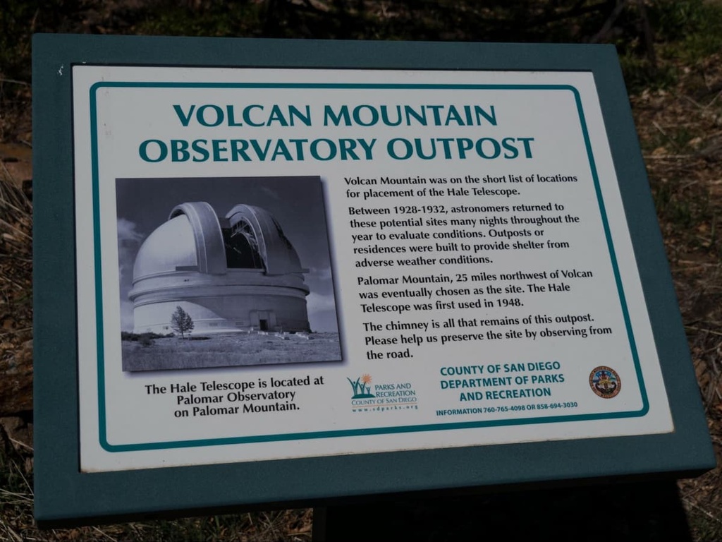
Volcan Mountain Trail – The summit of Volcan Mountain lies less than two miles northeast of the town of Julian. This is located in the new Volcan Mountain Wilderness Preserve and is truly worth a visit. The main trail to the top is also known as the Coast to Crest Trail and follows an old fire road; a newer trail (Five Oaks Trail) bypasses part of this route and offers a pleasant diversion that turns the hike here into a “dumbbell loop” (basically an out-and-back trail with a loop somewhere in the middle) of about six miles making for a more interesting experience. Total elevation gain is around 1,300 feet. This mountain has an interesting history – it was once a leading candidate for the Hale Telescope, which was ultimately built on Palomar Mountain just a few miles farther north, and became the largest telescope in the world when it was completed in 1949 – it is still in use today. Near the top of the trail is a commemorative exhibit about the outpost that was used by astronomers in their four-year search for the perfect location.
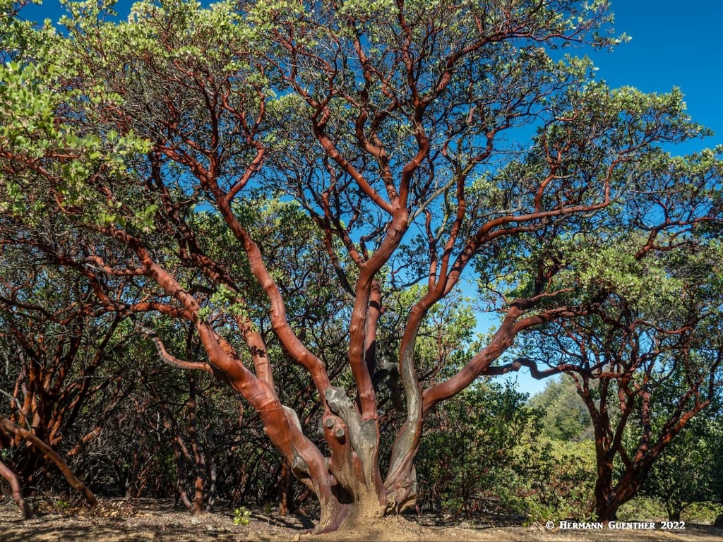
The views from the top of Volcan Mountain, elevation 5,330 feet, are impressive indeed (but see Garnet Peak below for even better views of the same area). The summit sits exactly halfway between the Pacific coast and the inland Salton Sea, which lies in the middle of the Anza-Borrego Desert at 236 feet below sea level. On a clear day it is possible to see both from here. The summit area has a picnic table as well as an information kiosk. Nearby is a beautiful carved memorial bench with an awesome view down into Banner Canyon that descends steeply down to the desert. On the main trail back down you will pass a long stretch of tree-size manzanita – these are characterized by a smooth bright-red bark. The berries on these trees have the taste of tart apples – manzanita is Spanish for “Little Apples”. When we hiked here these trees were in full bloom and if you didn’t see it you certainly would have heard it – thousands of honey bees buzzing around.
Granite Mountain – Less than 10miles to the east of Julian is the trailhead for Granite Mountain. While Julian sits in a lush mountain setting, the area around this trailhead is anything but lush. This is the desert – hot and dry and 2,000 feet lower. But for those who want to hike in an unforgiving environment, Granite Mountain may just be the challenge they are looking for. To begin with, the summit, though much higher than Julian, is not lush and green. The trail to the summit involves 3,200 feet of elevation gain in about three miles of rough terrain. This is considered a very difficult hike and must not be taken lightly. Experienced hikers have said that this hike is “no joke”, a “knee buster” or will “never be coming back”. This is not for inexperienced hikers as it involves serious navigation issues, rock scrambling and dealing with severe weather conditions – high winds, snow and extreme heat. Don’t even think about doing this in the summer. But the reward is amazing views from the top. I have not done it and never will!
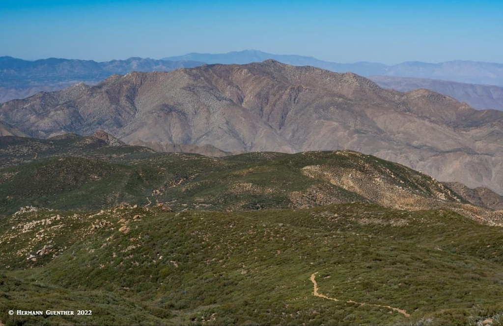
Along the eastern edge of the San Diego County mountains is the small subrange known as the Laguna Mountains. This wonderful recreation venue is like no other in southern California when it comes to fine hiking terrain and scenery - at least in my opinion. When first driving on the Sunrise National Scenic Byway, you don’t realize exactly what is up here. The terrain along the west side of the road seems mostly rolling and gentle in appearance - until you suddenly get a view to the east between the several peaks of the Laguna Mountains. Here, the terrain suddenly plunges into the depths of the Anza Borrego Desert several thousand feet lower. Deep canyons and steep cliffs characterize this place. This is where the famous Pacific Crest Trail (PCT) meanders on or just below the pronounced ridge line. This is some of the finest hiking in San Diego County.
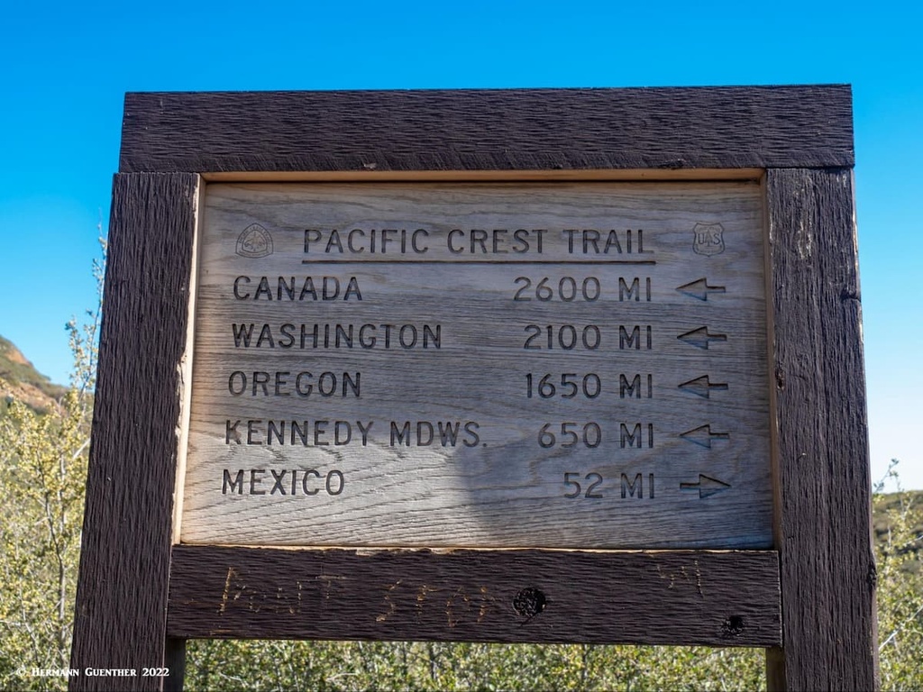
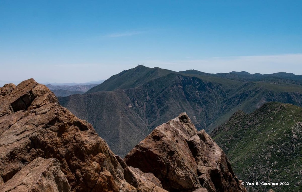
There are a number of trailheads where the PCT, which goes from Mexico to Canada for a distance of 2,652 miles, passing through the states of California, Oregon and Washington, can be accessed. A particularly fine hike is to start at the Pioneer Mail Trailhead, follow the PCT south a few miles and then take the half-mile spur to the summit of Garnet Peak (elevation 5,899 feet). The final hundred feet to the summit is a rock scramble on which good footing is necessary and hiking sticks can really help. Once you reach the tiny summit, take a deep breath before you look over the edge. You will be stunned by the dizzying eastern cliffs of the escarpment that drops away from the top. To the southeast, you will have a fine view of Monument Peak three miles away and Cuyapeipe, the highest peak in the Laguna Mountains at 6,381 feet.
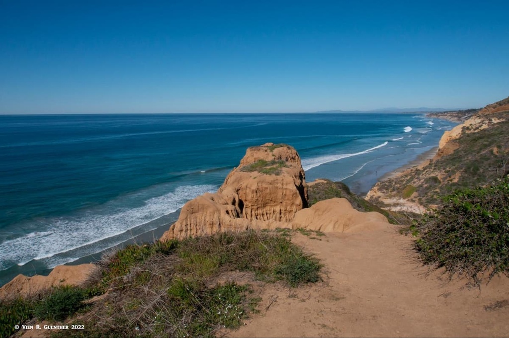
San Diego County is perhaps more widely known for its seacoast than for its mountains, as is indeed most of California. But even though we are all about mountains, which includes hiking, then we should also pay some attention to hiking along the coast. I don’t mean strolling barefoot on the beaches; I mean actually putting on hiking boots and a backpack. True, we are not talking about major distances and elevations here although if you hike enough you can get a really good workout here. I am talking about what is likely the best coastal hiking in the county – Torrey Pines State Reserve, part of the extensive system of state parks in California. Only about 15 miles north of downtown San Diego, this is a wonderful place to spend a good part of the day. There is actually a named “mountain” here – Red Butte, the highest point of the Reserve. If you are lucky, you may even see whales spouting off shore. And in good weather, which is almost always, you can see all the way to the mountains which are anywhere between 15 and 40 miles to the east. This is truly worth a visit.
San Diego is a world-class city, and those of us who live here or nearby are the envy of millions of people who would love to call this place home. Mainly because of the fine climate and nearby beaches. Being such a cosmopolitan city, visitors are assured that they can find all the amenities that travelers need, often at prices they would rather not have to deal with. But when on vacation, cost is not always the primary consideration. With everything this city has to offer, why not splurge a bit? Most major tourist attractions are either in the city or not far away in the greater urban area. For those that really want to experience some hiking in the nearby mountains, there are many trailheads that are easily reached within a one-hour drive from the city. Add another 30 minutes and you can reach just about any trailhead in San Diego County. If you are a visitor from outside of the area, and you are planning to do some hiking here, do try to give yourself some extra time to see the sights.

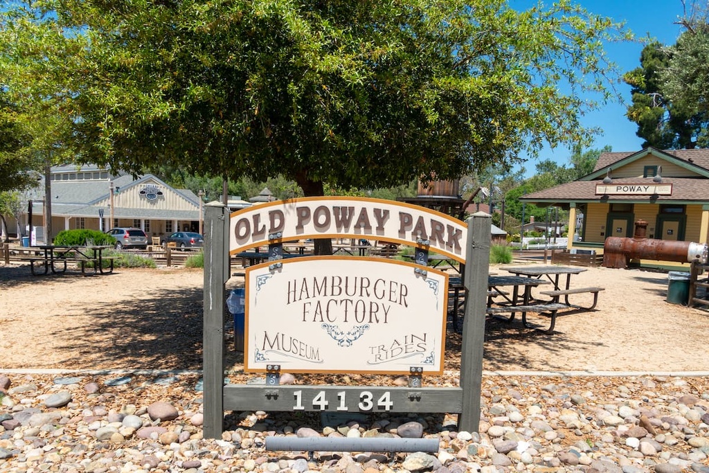
Though the city of Poway has its roots in agriculture (thus its nickname “City in the Country”), the scarcity of water ultimately ended the town’s reliance on farming since it could not attract large-scale farmers and the accompanying population growth. It was only after a major metropolitan water district was established that developers started building huge housing tracts. Today the city is largely a residential community for people working for major employers in the greater San Diego area. Poway is ideally situated for hiking at some of the best (and most popular) hiking venues in the county. Both Iron Mountain and Woodson Mountain are both in Poway as are several parks and nature reserves. Lake Poway is very popular with fishermen who regularly catch trophy-sized trout here. There is also a historic park in the center of town featuring a farmers’ market, museum, historic buildings and vintage train rides.
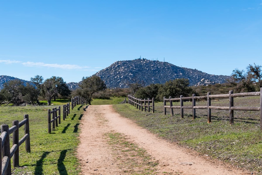
Ramona is an unincorporated community with a 2010 population of just over 20,000 located about 15 miles to the east of Poway, but well away from the urban bustle. The town was first called Nuevo, but was renamed in 1886, only to find out that another town in Los Angeles County was named Ramona, so it reverted back to Nuevo. But afterward, the other town floundered and was abandoned so that present-day Ramona got its name back. Like many places in southern California, Ramona has a rich history of early settlements by the Kumeyaay Nation of native Americans who migrated into and out of the area depending on the seasons. Today the area around the town is well known for its many vineyards and wineries due to favorable microclimate, elevation and soil attributes. There are a number of parks, reserves and walking/running trails in town. Depending on where you live, you can go hiking right from your doorstep.
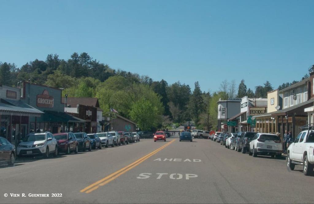
This small mountain town of 1,502 residents is the go-to weekend getaway for San Diegans – both summer (to escape the heat) and winter (to see the snow – something that is rarely seen anywhere else in the county). Used for years by early native peoples to spend their summers at the high elevations, it became a major attraction for European settlers after gold was discovered nearby. The population boomed. But the gold didn’t last. Local historians have suggested that in 1873, Julian’s population rivaled that of San Diego, and even attempted to shift the county seat to the town. But unlike many such mining towns, Julian survived because one man brought a load of young apple trees into the mountains where they flourished in the fresh, clear air and the rest is history. Julian is now a pleasant mountain resort and the apple trade has resulted in a mad race to buy the world-famous Julian apple pies. Believe me, they are good! But Julian is also a fine place to go hiking, even year-round, including summer when many other hiking venues in the county are far too hot. It still maintains its old-world charm.