
Scan the QR code and open PeakVisor on your phone
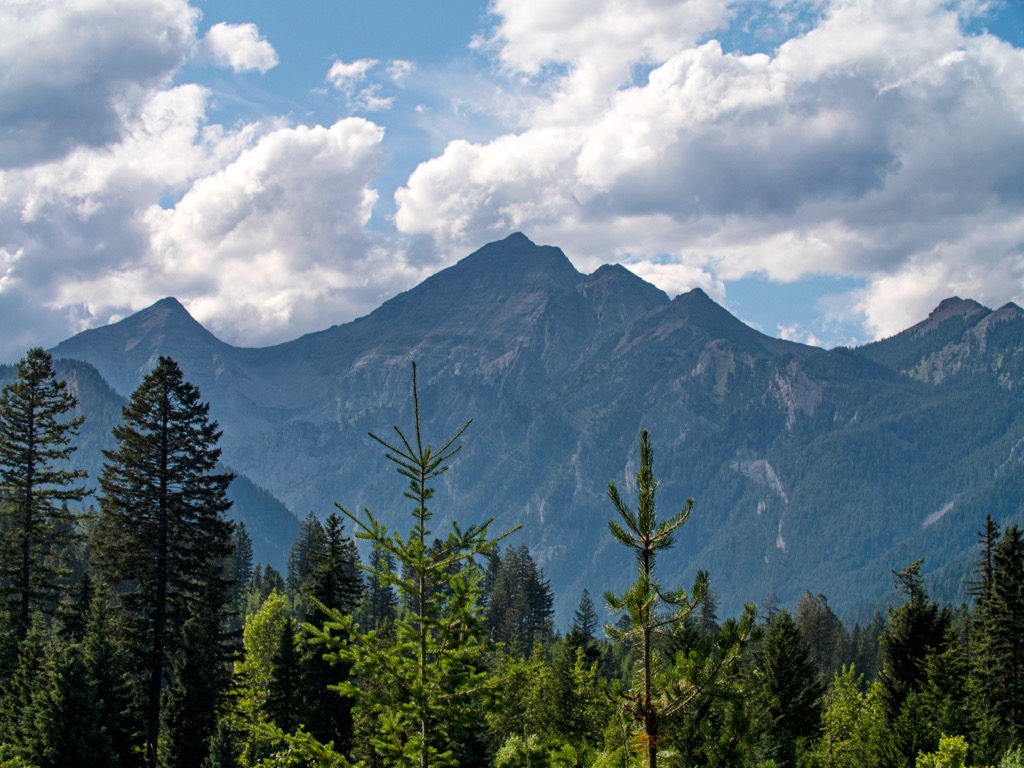
The Quinn Range is a collection of over a dozen peaks located in the Rocky Mountains of southeastern British Columbia in Canada. The range is a subrange of the Harrison Range, which also consists of the Harrison Group, Harrison Group East, Harrison Northeast. Mount Mike (3,304 m/ 10,840 ft) is the tallest and most prominent peak in the range.
Found within the southern ranges of the Canadian Rockies, the Quinn Range is in southeast British Columbia near the border with Alberta and the United States.
The range is surrounded by the rest of the Harrison Range, which includes the Harrison Group, Harrison Group East, and Harrison Northeast. The ultra-prominent peak of Mount Harrison (3,360 m/ 11,024 ft) is found in the Harrison Range. Mount Mike (3,304 m/ 10,840 ft) is the tallest and most prominent peak in the Quinn Range.
The resort town of Fernie is south of the Quinn Range and Highway 3 and Highway 43 run along the southeastern edge. Being situated in the middle of the Harrison Ranges, the Quinn Range is remote with limited access, except for a number of forestry roads that criss-cross the region.
While there are no provincial or national parks in the Quinn Range, the range is adjacent to some spectacular parks such as Top of the World Provincial Park, Whiteswan Lake Provincial Park, and Premier Lake Provincial Park.
As part of the Canadian Rockies, the Quinn Range shares its origin story. The Rocky Mountains started forming about 75 million years ago when the tectonic plates under the Pacific Ocean tried to occupy the space held by the North American continental plates.
The Pacific plates subducted beneath the continental plates and the intense friction created buckling and deformation of the continental crust. The force of the tectonic collision cracked and heaved the older Paleozoic layers of limestone and dolomite up and over the younger Cretaceous shales and sandstones.
The precipitous peaks of the Rockies are mainly composed of limestone, whereas much of the sandstone and shale were eroded. The erosive forces of wind and water started wearing down the mountains as they were forming; however, it’s the glaciers that created the topography of the mountains as we see them today.
Just over 2.5 million years ago, the world was cooling, and periods of glaciation were cycling, forming glaciers and ice sheets, such as the Laurentide ice sheet, which covered most of North America. The ice sheet, which was over a kilometer thick in places over the Rocky Mountains, finished grinding away the softer Cretaceous stone, leaving the durable limestone and dolomite peaks.
The glaciers carved out mountain sides creating cirques and moved enormous amounts of stone debris, leaving deposits as kames and sinuous eskers when they melted. The most recent glacial maximum ended about 12,000 years ago, and it created the current topography of the Rocky Mountains and the Quinn Range.
The Quinn Range has many diverse ecosystems that range from barren rocky peaks to dense cedar forests. The tops of the mountains are dominated by rocks with limited growth of sedge and lichen. The severe climate has cool summers and long, cold winters in the alpine and subalpine that limit the growing season.
Open parkland, with trees clumped and interspersed with meadow, heath, and grassland fill the subalpine, immediately below the alpine. Engelmann spruce, subalpine fir, and lodgepole pine are the dominant trees.
While the winters are cold, the lower elevations allow for a short, but relatively warm summer. Engelmann, hybrid Engelmann-white spruce, and subalpine fir are the common tree species, however, forests of lodgepole pine, Douglas-fir and trembling aspen commonly supplant previous forests after wildfires.
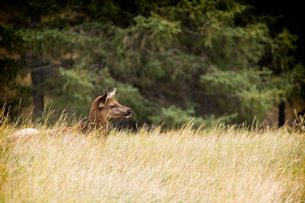
Grizzly and black bears are common in the range, as well as numerous small mammals such as pika, marmots, ground squirrels, and voles. Bird species, such as Forster’s tern, osprey, western grebe, and long-billed curlew inhabit the Quinn Range
The tall rocky peaks are a haven for mountain goats, which are the most common ungulate within the range. There are also substantial populations of white-tailed and mule deer, bighorn sheep, and elk. Furthermore, small populations of caribou inhabit the range, generally living in the old-growth spruce forests.
The initial habitation of the Quinn Range coincides with the end of the Pleistocene, when the glaciers were finally receding from the continent and habitable zones were formed. One of the first habitable zones that formed in what is now western Canada includes the eastern Rocky Mountains and it extended from Alaska and Yukon to the lower half of North America.
This habitable zone started forming about 14,000 years ago when a gap started to open between the continental ice sheet and the glaciers that covered the mountains. As the ice receded from the valleys of the mountains, vegetation started growing which attracted herd animals. People and other predators soon followed the migrating ancient animals into the recently thawed areas.
It is speculated that while the “ice-free corridor” was opening along the eastern slopes of the Rockies that the Kootenay region was experiencing a similar thaw. Throughout East Kootenay there is significant evidence of the ancient inhabitants in the region in the form of ancient quarries, workshops, and campsites.
These ancient groups would quarry chert, which is an opaque gray sedimentary stone, which when fractured can produce a very sharp edge. Chert was valuable for tools and trading, as it can be used to make durable and sharp hunting points and blades.
The Quinn Range and District of East Kootenay are the traditional lands of the Ktunaxa Nation. The name Kootenay, which are names of the river, valley, and adjacent mountain range is the anglicized derivation of their spoken name.
Archeological evidence suggests a possibility that the modern Ktunaxa who inhabit the Kootenays are the descendants of the indigenous people that first inhabited the region over 10,000 years ago. It wasn’t until the early nineteenth century that European explorers entered the Quinn Range and made the first European contact with the local First Nations.
However, it should be noted that the Ktunaxa traditionally inhabited and hunted throughout a very large territory. Their territory stretched from the Kootenay and Columbia rivers to the eastern slopes of the Rockies and the prairies beyond.
There is evidence of regular migrations across the mountain passes when the Ktunaxa hunted bison on the plains. The arrival of the Blackfoot Confederacy on the plains and eastern slopes pushed the Ktunaxa back over the Rocky Mountains.
The Quinn Range is currently uninhabited; however, there is significant logging which has occurred on the northeastern slopes of the range. The region’s economic success has been strongly tied to forestry and mining since the beginning of the twentieth century.
At the beginning of the twentieth century a railroad was built through the region which finally connected the region’s natural resources to the Pacific coast and the rest of Canada.
The Quinn Range is not a typical destination; however, there are many opportunities for backcountry travel and adventure in the range. Visitors to the range will often cam at either the 40 Mile Camp Recreation Site at the south end of the range or the White River Recreation Site at the north end of the range.
The plentiful logging roads give relatively easy access to all the major peaks in the Quinn Range; however, there are no official trails. The Quinn Range requires route-finding and experienced backcountry skills to navigate and stay safe. For those willing to venture into the backcountry of the Quinn Range, you will not be disappointed by the sights and the seclusion.
The following are some of the best places to stay and visit while adventuring in the Quinn Range:
Initially Sparwood was nothing more than a railway stop in the late nineteenth century named for the lumber that was harvested from the area and sent to the shipyards to make spars for the ocean liners. Mining coal and lumber have been the primary economic drivers of the region and Sparwood has fully embraced their history and the mining culture.
Officially incorporated in 1966, the population of Sparwood increased significantly as two nearby towns were shuttered because of their proximity to the coal mines and the residents were encouraged to move to Sparwood.
Putting their appreciation for mining on display, along the Crowsnest Highway on the edge of Sparwood sits a giant green monster of a dump truck called the Terex Titan. The Titan serviced the coal mines from 1978 to 1991 and at one time was the largest truck in the world and is now an iconic landmark and tourist stop. Next to the Titan is the visitor center in which you can be directed towards local adventure.
From the visitor center you should pick yourself up a map of the Sparwood trails. Created and maintained by the Sparwood Trails Association, there are kilometers of trails for hiking and cycling. During the winter, the trails are groomed for fat biking, cross-country skiing, and snowshoeing. While not a city, Sparwood is a good-sized town that will have everything you need for an adventure into the mountains.
Located along Highway 3, in British Columbia at the south end of the Quinn Range, Fernie was founded in 1898 by William Fernie as he made claims to the land and started mining the nearby coal reserves.Fernie was incorporated as a city in 1904 and is the only city-class municipality to be completely surrounded by the Rocky Mountains.
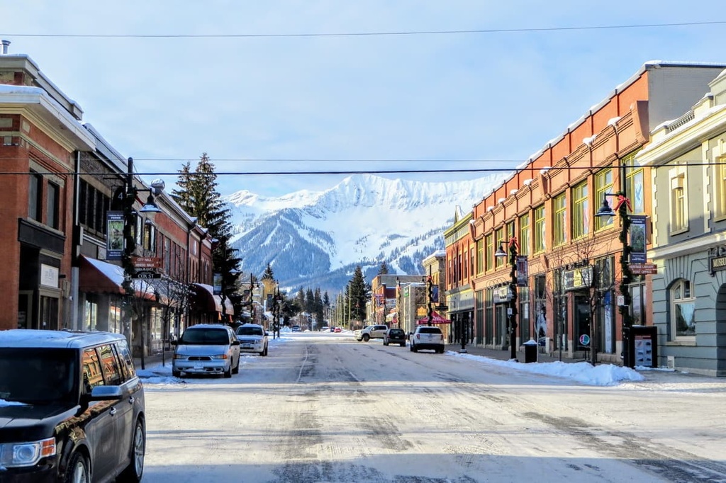
While Fernie started as a coal mining town, it has embraced the mountain culture like the towns of Banff and Canmore, in Alberta, to become a tourist hotspot, especially during the winter months. Skiing is especially popular near Fernie, thanks to the Fernie Alpine Resort, which was originally created in the 1960s and has since grown to be the modern ski resort that we all know and love.
In 1904 a fire demolished the densely built wooden buildings of Fernie’s original commercial district; however, they were rebuilt with similar wooden construction. In 1908, a second fire obliterated the town in 90 minutes. Since this time, a bylaw has been enacted that requires all municipal buildings in the downtown of Fernie to be constructed of fire resistant brick and stone.
Fernie has incredible activities, amazing scenery and wildlife, and an adorable downtown filled with charming stone buildings. Some of the nearby wilderness areas that are worth visiting are Mount Fernie Provincial Park, Morrissey Provincial Park, Elko Provincial Park, and Kikomun Creek Provincial Park.


