Scan the QR code and open PeakVisor on your phone
The Swallow Creek Wildlife Management Area (WMA) is an administrative area situated within the Chattahoochee-Oconee National Forest that’s located in the northeastern part of the US state of Georgia. The region features dense forested hillsides and various streams. There are 23 named mountains in the area, the highest and most prominent of which is Double Spring Knob (4,278 ft/ 1,304 m).
The Swallow Creek WMA is located in the northeastern corner of the US state of Georgia. It lies within the Chattooga District of the Chattahoochee-Oconee National Forest.
The entire ranger district spans 261,035 acres (105,637 ha) while the WMA covers 19,000 acres (7,689 ha) in Towns County. Much of the region is densely forested with steep hillsides and valleys while open fields are interspersed throughout..
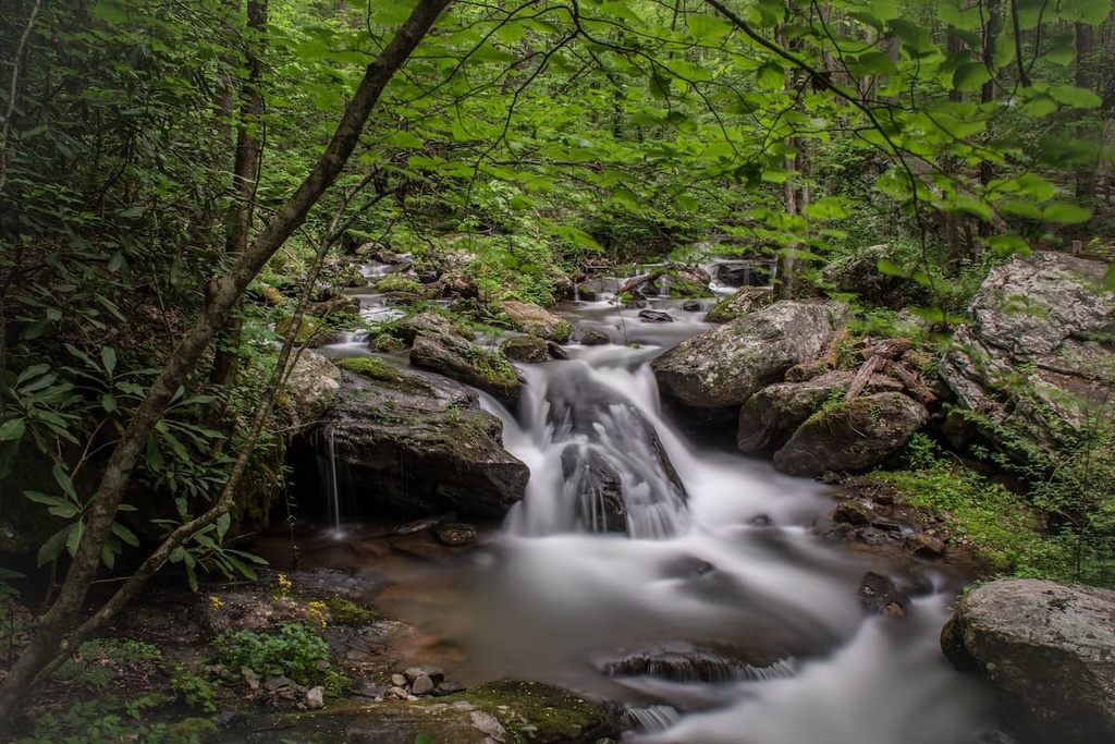
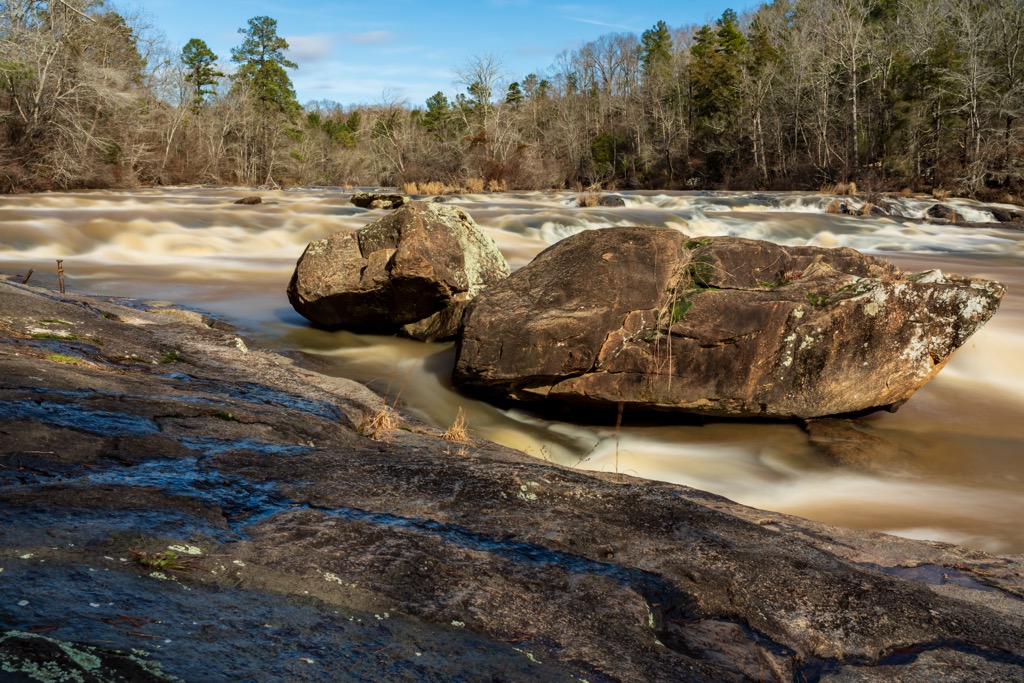
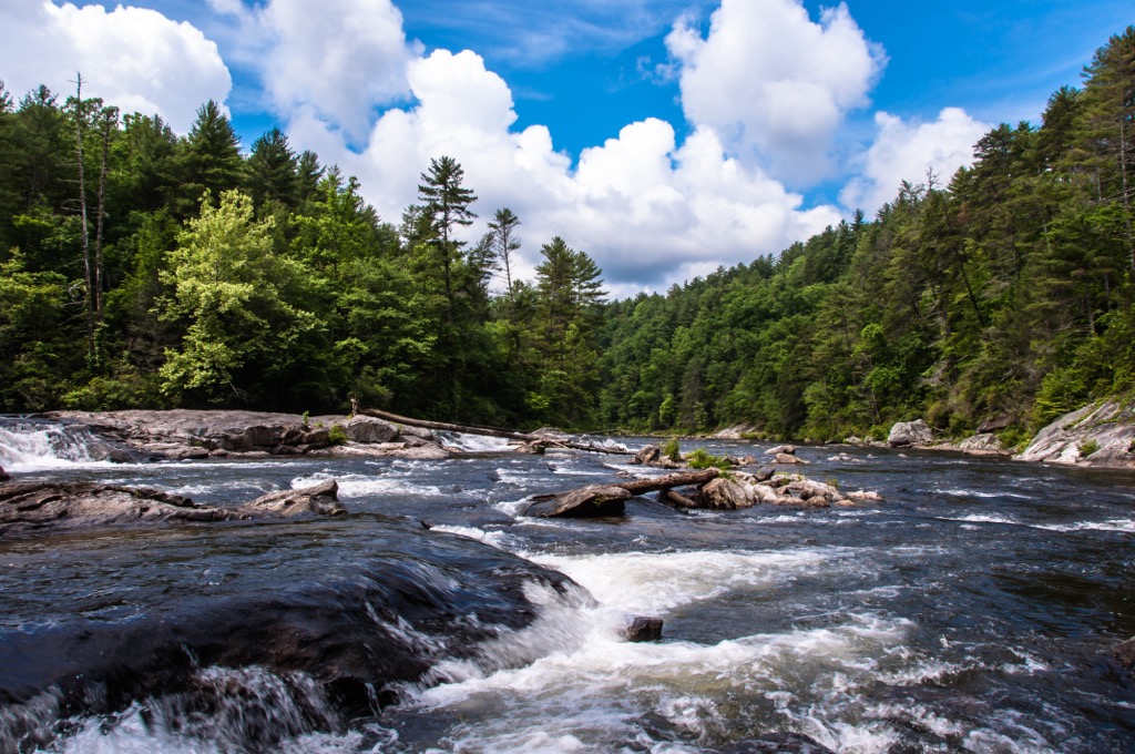
The Hiwassee River marks the western boundary of the WMA while Hightower Creek marks the northern boundary. Various seasonal creeks and streams flow throughout the region along with small lakes and ponds.
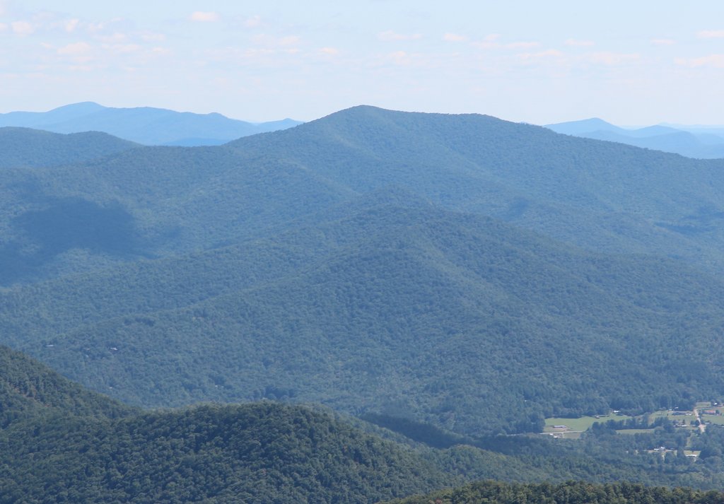
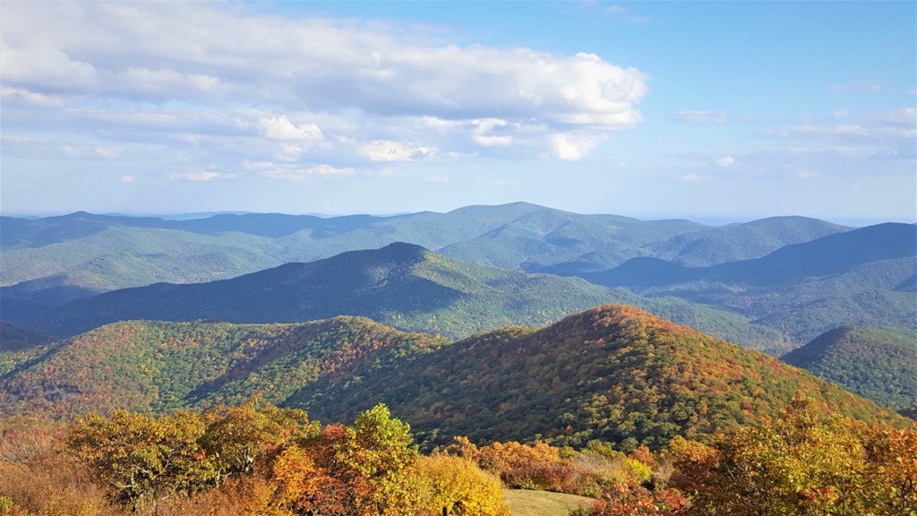
Lake Burton lies east of Swallow Creek while Chatuge Lake is situated to the northwest. The ridgelines and hills in the area are part of the Blue Ridge Mountains which extend along the east coast of the US, up into Canada.
Various service roads run through the wildlife management area, providing easy access to the various hiking trails. There are approximately 25 miles (40 km) of hiking trails throughout the area. Hikers should note that parts of the region are used for hunting.
The Swallow Creek WMA lies within the Chattooga District of the forest. Nearby protected areas include Tray Mountain Wilderness, while Southern Nantahala Wilderness lies to the north, and Henry Grady Burrell Preserve is to the west. The Mark Trail Wilderness extends to the west along with the Chattahoochee Wildlife Management Area.
The peaks within the Swallow Creek WMA are part of the Blue Ridge Mountains system. The range is part of a physiographic province which features distinct geological structures.
The Blue Ridge Mountains began taking shape during the Alleghenian and Grenville orogenies which lasted from around 1.1 billion years ago to 250 million years ago. This range is known for being much older than other major ranges such as the Alps and Himalaya.
Vast seas and rivers have slowly eroded the range, giving way to the alternating ridges and valleys. The peaks are primarily composed of metamorphosed rocks which date back to the Precambrian and Paleozoic eras.
Rocks found in the WMA also include granites, schists metagreywacke, and gneisses. These peaks are also part of a larger Appalachian Mountains which influences the flora and fauna found throughout the southeastern US.
Major peaks within the Swallow Creek WMA include Double Spring Knob, Rocky Mountain, Berrong Mountain, Nell Knob, and Brier Creek Bald.
Despite its relatively small size, the WMA features a diverse array of both flora and fauna. As part of the Blue Ridge ecoregion, the plants and animals found in the area are similar to that found throughout the southeastern US.
The forested sections primarily consist of mixed pine-hardwood forests along with shortleaf pine, oak, hickory, and loblolly. Spruce and fir trees are less common in this portion of the Blue Ridge Mountains due to the relatively low elevations of the peaks. Other plants in the region include bloodroot, sassafras, fire pink, and mayapple.
The WMA is also used as a hunting region for deer, turkey, black bear, and smaller game. Other common animals include beavers, bobcats, and weasels. Common bird species are the red-eyed vireo, ovenbird, warbler, and Carolina chickadee. Birds of prey such as hawks, eagles, and owls are also common.
At night visitors may be able to spot the Phausis reticulata (blue ghost) firefly which can be found throughout the Blue Ridge Mountains.
The land in what is now the Swallow Creek Wildlife Management Area has been home to humans for thousands of years. This region marks the ancestral homelands of various Indigneous groups, primarily the Muscogee (Creek) and Cherokee Nations.
Though this region marks part of the ancestral homelands of these nations, both are currently located in present-day Oklahoma. The tribes were forcibly removed from the region in the 1800s following the Indian Removal Act of the 1830s. This led to what was known as the Trail of Tears while many tribes from the east coast were forced to leave their land, drastically reducing their numbers.
One of the first people of European descent to visit the region was the Spaniard Hernando de Soto. He traveled throughout the southeastern US throughout the mid-sixteenth century. During the eighteenth century, the region of Georgia became a British colony.
The region quickly developed into an agricultural hub as slavery was brought to the US. Large plantations began cropping up throughout Georgia and the southeastern US. This northern section of Georgia also became an important site for logging and mining.
The discovery of gold in the Blue Ridge Mountains led to the Indian Removal Act, forcing the Indigenous peoples from their homelands. A series of railroads were constructed after the gold rush, drastically affecting the natural landscape.
Land purchased in 1911 would later go on to become the Cherokee National Forest, which would later be renamed the Chattahoochee National Forest in 1936. During this year, the boundaries of the forest were redrawn and further expanded.
The Swallow Creek Wildlife Management Area has since become a hub for both hunting and hiking in northeastern Georgia.
The Swallow Creek Wildlife Management Area is home to around 25 miles (40 km) of trails, many that connect to surrounding protected areas. Here are some of the best hikes to check out during your next trip:
This loop trail is the most popular hiking route in the WMA. The route begins on Highway 17 and travels up to the summit of Rocky Mountain, the second most prominent peak in the area. A section of the trail is part of the Appalachian Trail which extends along much of the eastern US.
Hikers are rewarded with views of the surrounding mountains and ridgelines, sweeping forested landscapes, and seasonal creeks and streams. The trail is quite rocky in some sections so proper footwear is recommended. The loop is 5 miles (8 km) in length with 1,742 feet (531 m) of elevation gain.
In the WMA, hikers have the option to complete this point to point portion of the Appalachian Trail. The route begins along the western edge of the WMA and travels northeast through the region, ending along Highway 76.
This rugged trail showcases the beauty of the region while passing Double Spring Knob and Rocky Mountain. The point to point trail is 15.8 miles (25 km) in length with 4,704 feet (1,434 m) of elevation gain.
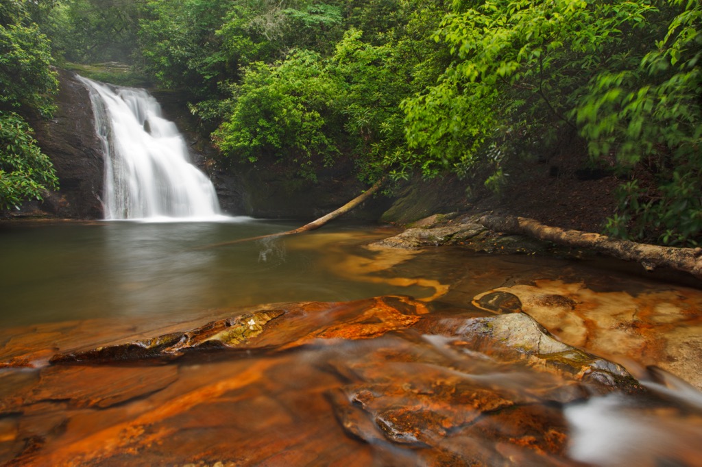
High Shoals Falls Trail is a shorter route in the WMA. The trail begins by descending next to the High Shoals Creek before coming to the falls themselves. The cascading water features a small pool at its base which is occasionally used for swimming during the warmer months.
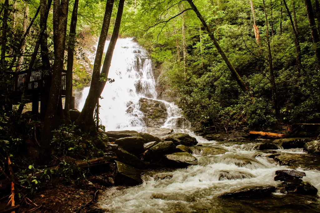
The out and back trail is 2.6 miles (4.2 km) long and features 577 feet (176 m) of elevation gain. Sections of the trail feature a steep incline and rocks that are often wet.
Looking for a place to stay near the Swallow Creek Wildlife Management Area? Here are some of the best cities and villages to check out in the region.
The city of Atlanta lies just a two hour's drive to the south of the WMA. Home to around 500,000 residents, Atlanta acts as the capital and most populous city in the state. Due to its central location, Atlanta is the cultural and financial hub of the entire region.
The city is home to a multitude of historical and cultural sites and districts. Some of the most popular sites include Martin Luther King, Jr. National Historical Park, High Museum of Art, Centennial Olympic Park, Piedmont Park, and the Atlanta Botanical Garden.

The restaurants and music of the region showcase numerous cultures that have shaped the city. Southern cuisine and hospitality can be found throughout your time exploring the city of Atlanta.
The city of Greenville is located in northwestern South Carolina, east of the WMA. The city is home to around 71,000 residents and lies between the major cities of Atlanta, Georgia, and Charlotte, North Carolina. The city acts as an economic and cultural hub for northwestern South Carolina.

The city is known for its quaint downtown streets, local cuisine, and plethora of outdoor activities. In recent years, Greenville has been awarded titles such as the South’s Most Tasteful Small Towns and one of the Most Underrated Travel Destinations of the Year.
The Falls Park on the Reedy and the Greenville County Museum of Art are popular attractions along with the surrounding national forests. Popular festivals in the city are the Fall for Greenville and Euphoria Greenville.