Scan the QR code and open PeakVisor on your phone
Located in the Boundary Ranges of northern British Columbia, Canada, along the province’s border with the US state of Alaska, Lava Forks Provincial Park is an incredible protected area that’s home to the site of Canada’s most recent volcanic eruption. The rugged volcanic landscape in the region is dominated by Olatine Mountain (2,309 m/7575 ft), which is the tallest of the 5 peaks in the park.
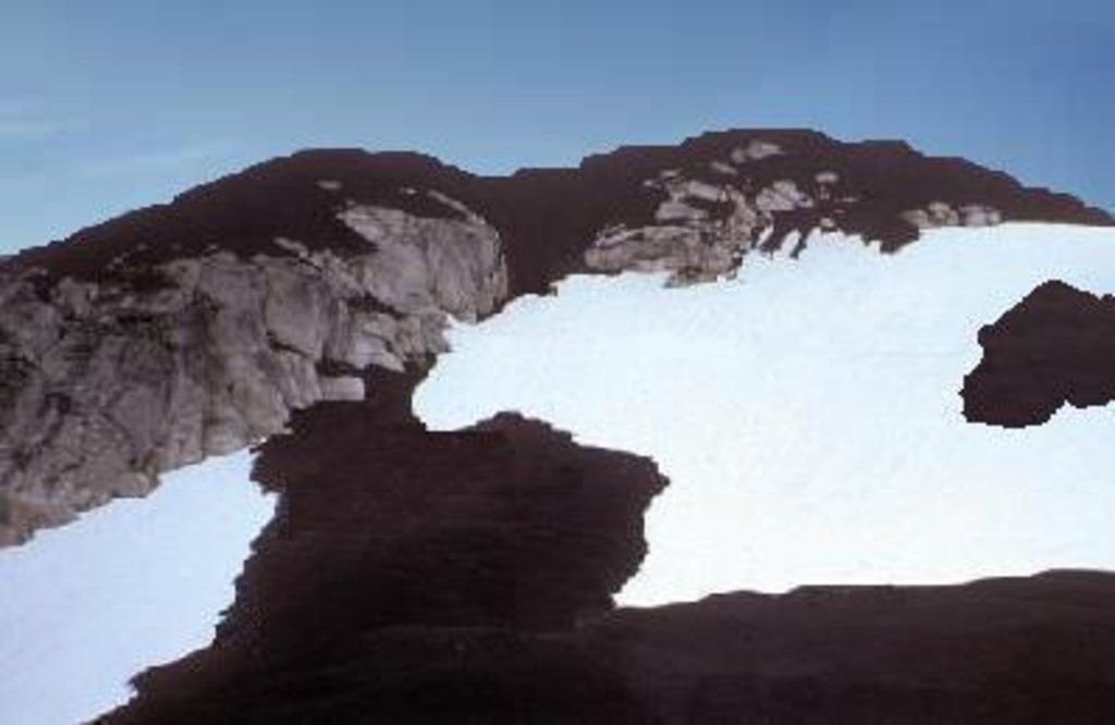
Lava Forks Provincial Park is a protected area located in the northern part of the Canadian province of British Columbia near the province’s border with Alaska. The park features the formations and ecosystems that resulted from Canada’s most recent volcanic eruption, which is believed to have occurred around the year 1904. In the park, you can also find a lava-filled valley, which stands in stark contrast to the surrounding ice-capped mountains.
The tallest of the five peaks in the park is Olatine Mountain, which stands at over 2,300 m (7,500 ft) tall and has 761 m (2,497 ft) of prominence. The remaining peaks in the park are Ptarmigan Peak, Glacier Dome, Mosheim Dome, and The Volcano.
Lava Forks Provincial Park is located in the Boundary Ranges of the Coast Mountains. The park’s volcanic features also extend across the Alaskan border to Tongass National Forest. There is no road or water access to the region, so the most feasible way to reach the park is by helicopter, as hiking to the area from the nearest town would likely take several days.
Nearby parks that represent similar, albeit, less volcanic versions of the Boundary Ranges ecology include Craig Headwaters Protected Area, Border Lake Provincial Park, and Great Glacier Provincial Park. Additionally, about 100 km (60mi) to the northeast of Lava Forks Provincial Park, you can find a number of other ecologically important parks, such as:
The peaks within Lava Forks Provincial Park are part of the southern Boundary Ranges of the Canadian Coast Mountains. The Boundary Ranges are an ice-capped, granitic, and metamorphic range that rises abruptly from the Pacific Ocean.
The Boundary Ranges and the Coast Mountains as a whole started to rise about 130 million years ago as a group of mainly volcanic islands accreted to the western edge of ancestral North America. This Paleozoic and Mesozoic-aged terrane of the ancient Coast Mountains was further compressed and uplifted as exotic terranes, like the Wrangellia and Alexander terranes, also collided with the west coast of North America.
Furthermore, the subduction of the Kula and Farallon tectonic plates, which underlaid the Alexander and Wrangellia terranes, created an area of arc volcanism along the coast of the continent. This volcanic arc intruded the terranes’ layers of sedimentary rock with magma, which metamorphosed the surrounding rocks and produced schist.
As these magma intrusions slowly cooled, they became the granite batholiths that now form the backbone of the Coast Mountains. The 1904 volcanic eruption of The Volcano in Lava Forks Provincial Park is evidence that these major geological processes still occur in western Canada and southeastern Alaska. Further evidence of these geological processes can be seen in the mineral springs that are found in the park.
During the Pleistocene, the cordilleran ice sheet overrode most of the Boundary Ranges; however, the lava flows in the park are significantly younger than the ice sheets and they stand in stark contrast to the surrounding ice-capped mountains.
The peaks in the region that were not affected by the recent lava flows were affected by the ice sheet and alpine glaciation during the Pleistocene, the latter of which created cirques below some of the summits in the park.
The lower peaks and ridges of the region tend to be rounded over, thanks to the erosive power of this ice sheet. Meanwhile, the region’s valley walls were steepened and truncated by this ice sheet to create typical U-shaped glacial valleys.
The eruption of The Volcano created new topographical features in the park, including two lava-dammed lakes, pot holes, and ash dunes. The typical glacial veneer that is present throughout the rest of the region has been covered by the recent lava flows; however, as evidenced by these ash dunes, water and wind are major erosive forces that continue to act upon these mountains to this day.
Lava Forks Provincial Park lies within the southern Boundary Ranges ecosection. The ecology and climate of the park are heavily affected by the cold Arctic air that flows down the Portland Canal and the moist Pacific air from the Gulf of Alaska.
The lower elevations in the park typically feature very wet Coastal Western Hemlock forests while the subalpine zones of the region are typically home to cold and wet Mountain Hemlock forests. The Coastal Western Hemlock forests are the classic type of rainforests found on the west coast of British Columbia as they are filled with red cedars, amabilis fir, Sitka spruce, Douglas fir, and western hemlock.
The subalpine Mountain Hemlock forests in the park are often filled with mountain hemlock, yellow cedar, and amabilis fir. The alpine area of the southern Boundary Ranges ecosection is extensive; however, it is typically ice-covered or barren rock.
The slopes of the park that were unaffected by the lava flow during the most recent volcanic eruption are filled with mountain hemlock and yellow cedar, which outgrow the western hemlock and red cedar at the higher elevations of the park.
However, the most interesting ecological feature of Lava Forks Provincial Park is not its climax forests, but rather its areas of primary plant succession.
When the most recent volcanic eruption occurred, its lava flows wiped out all of the ecosystems in their paths. Since then, these affected areas have undergone the early stages of plant succession. Indeed, mosses and lichens already cover the upper part of the lava flow layer, and they set the stage for future ecosystem growth in the coming decades.
Furthermore, due to the park’s well-protected area of plant succession, it is a relatively popular area for researchers who study these types of ecosystem disturbances.
The area that is now Lava Forks Provincial Park is located on the traditional territory of the Tahltan First Nation. While the remoteness of the park has prevented an accurate cultural assessment of the area, it’s clear that the Tahltan have hunted, trapped, fished, and foraged the resources of the surrounding region for generations.
The first people of European descent to come to the region that is now Lava Forks Provincial Park were likely fur trappers and traders. European trappers and traders started arriving in the region during the late eighteenth century in search of valuable pelts, though most of the European settlements in the area that is now northwestern British Columbia and southeastern Alaska were located closer to the coast.
Lava Forks Provincial Park was created by the government of British Columbia in 2001 in order to protect its volcanic landscape. It was also set aside to allow for scientific research in the area, particularly for researchers who study primary plant succession.
As the park is only reasonably accessible via helicopter, it receives relatively few visitors each year. Most visitors come to study the volcanic landscape and ecology of the park; however, the area is open to the general public, and backcountry enthusiasts who are willing to make the trek will likely enjoy visiting the unique and remote wilderness of the park.
There are several major attractions that bring visitors to Lava Forks Provincial Park. The volcanic landscape is the obvious attraction, though the region’s unique ecosystem is also a highlight for many of the park’s visitors.
Aside from scientific study, there are a number of reasons why Lava Forks Provincial Park would make for an incredible destination for a keen backpacker, including:
That said, the sensitive nature of the landscape and ecology in Lava Forks Provincial Park requires that all visitors and scientists in the region adhere to the principles of Leave No Trace during their travels.
While there are no official trails or facilities in the park, if you happen to find yourself fortunate enough to visit Lava Forks Provincial Park in the future, please be sure that you tread lightly wherever you may go.
As it is located in a very remote part of northern British Columbia, there are no settlements or towns that are situated near Lava Forks Provincial Park. The following are some of the communities that are located closest to the park and that offer accommodations and services to visitors in the region.
Wrangell is a city of about 2,100 people that’s situated on Wrangell Island near the coastal outlet of the Stikine River in southeastern Alaska. Although Wrangell is located on the Alaska side of the Boundary Ranges, it is only about 50 km (30 mi) away from Lava Forks Provincial Park as the crow flies.
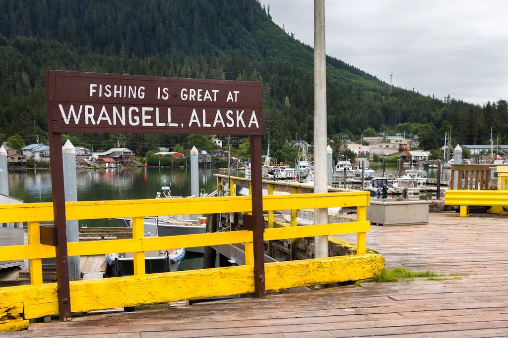
Wrangell is part of the ancestral homelands of the Tlingit, who have lived in the region for thousands of years. While in Wrangell, it’s definitely worth checking out the ancient petroglyphs at Petroglyph Beach. The petroglyphs at this beach attest to the long history of Tlingit settlement in the region.
After you visit Petroglyph Beach, there are opportunities for flightseeing, bear viewing, kayaking, hiking, and fishing in Wrangell. Tours up the Stikine River are popular among visitors to Wrangell, too, as are trips to view the many glaciers in the region.
Prince Rupert is a city that’s located about 250 km (150 mi) to the south of Lava Forks Provincial Park. Even though it’s situated quite a distance from the park, the city is the transportation hub of British Columbia’s north coast, and visitors to Lava Forks are likely to pass through Prince Rupert on their way to their northern adventures.
The history surrounding the people that first inhabited the area that is now known as Prince Rupert extends back over 5,000 years. Multiple First Nations have lived in the area over the millennia, traditionally relying upon fishing for their sustenance. The forests and coastline of the region provided all that First Nations traditionally needed to thrive, from fish and berries to fur pelts.
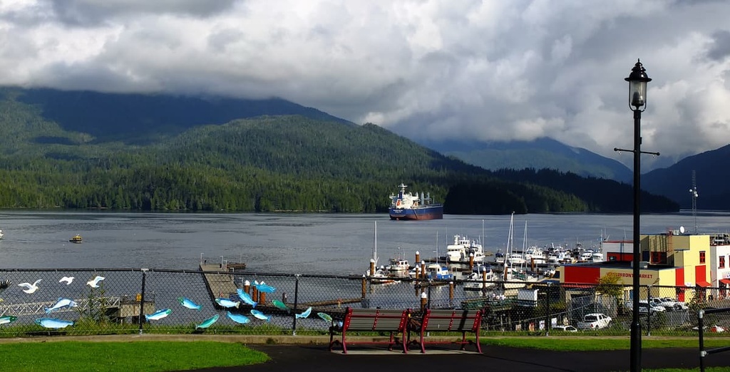
While in Prince Rupert, you may want to consider a tour of the Khutzeymateen Grizzly Bear Sanctuary, which features one of the densest populations of grizzlies in North America. Tours regularly depart from Prince Rupert as it is the starting point for many wildlife viewing trips in the region, especially if you want to see grizzly bears, salmon, eagles, and whales.
If you’re looking to get out for a day hike while in Prince Rupert, some of the most popular hikes in the area include the Butze Rapids Trail, Tall Trees Trail, and the trail to Wantage Falls. If you’re interested in completing a peak ascent while in town, you can also hike Mount Hays via the Kiwanis Trail.