
Scan the QR code and open PeakVisor on your phone
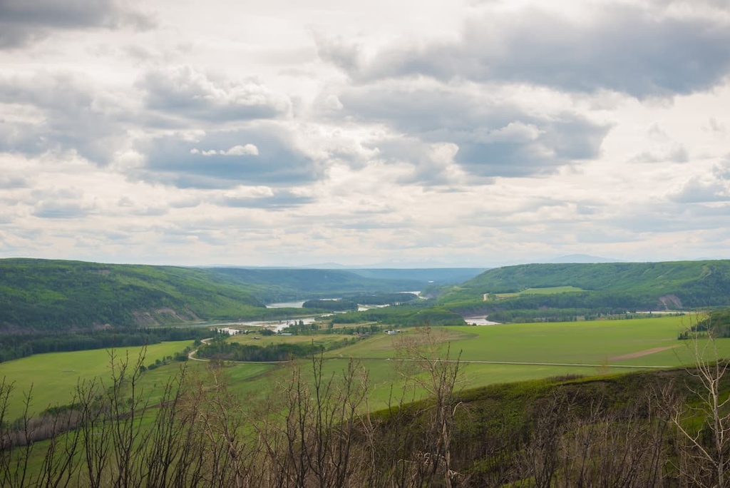
Located along the Continental Divide at the headwaters of the Peace River in northeast British Columbia, Canada, Bocock Peak Provincial Park contains 11 square kilometers (4 square miles) of land. There is one peak in the park, Bocock Peak, which is 1,939 m (6,362 ft) tall and has 419 m (1,375 ft) of prominence.
Bocock Peak Provincial Park is located to the south of the Peace Arm of Williston Lake in northeastern British Columbia, Canada. Bocock Peak is part of the Hart Ranges of the northern Rockies. It has an elevation of 1,939 m (6,363 ft) and a prominence of 419 m (1,375 ft), making it a relatively easy summit to attain—except there are no official roads or trails to the park.
Travel to Bocock Peak usually starts from Hudson’s Hope, which is the nearest community to the park. Hudson’s Hope is located about 70 km (42 mi) to the east of the park.
Bocock Peak Provincial Park is located in a very remote part of British Columbia. However, there are few other parks situated within close proximity to it.
The other relatively nearby parks include Omineca Provincial Park and Muscovite Lakes Provincial Park to the west, Klin-se-za Provincial Park and Butler Ridge Provincial Park to the east, Graham–Laurier Provincial Park to the north, and Pine Lemoray Provincial Park to the south.
Bocock Peak is part of the Hart Ranges of the Far Northern Rockies. The peak’s geologic history stretches back nearly 400 million years to when western Alberta was the edge of the continent and a vast shallow sea stretched to the west. For millions of years, sediment accumulated on the seafloor, compressing the layers below into thick slabs of limestone.
About 75 million years ago, the tectonic plates under the Pacific Ocean were pressing against and subducting under the western edge of the North American plate. This caused the continental margin to buckle and lift. Previous similar tectonic collisions formed the Columbia Mountains and the Coast Mountains of the Western Cordillera.
The buckling and deformation of the rock layers at the continental margin also created areas where lava came to the surface and poured out, which is how the interior plateaus of British Columbia formed. One of the final mountain building acts in western Canada was the creation of the Rocky Mountains.
As the tectonic plates collided, the continental crust was compressed until it cracked and was thrust up and above the ground to the east. For over 35 million years, the plates collided, causing a series of cracks and thrusts that created the Rocky Mountains as the Paleozoic limestone was pushed on top of the Cretaceous sandstone and shale.
Bocock Peak was created from the durable limestone layer that resisted erosion to create a peak, whereas the layer of sandstone and shale typically eroded to create the major valleys between the rows of mountains. Furthermore, Bocock Peak has several karst cave systems that are rather unique in the region.
Karst caves are more commonly found in tropical locations; however, their origin is the same, even if they’re now found in the northerly latitudes. Karst caves typically formed as water flows through faults and cracks in limestone, eventually eroding away the rock and creating a cave. Depending on the conditions, kart cave systems can be quite large and complex.
Of the three karst caves that are found upon the slopes of Bocock Peak, one of them is 253 m (830 ft) deep and is the ninth deepest cave system in Canada. Other limestone caves are found to the northeast of the park near Charlie Lake. While the caves at Charlie Lake are smaller, they are significant for having provided shelter to the Indigenous peoples who lived in the area over 10,500 years ago.
The two significant ecological zones of Bocock Peak Provincial Park are the Boreal Altai Fescue Alpine zone and the Engelmann Spruce – Subalpine Fir zone.
Significant portions of the park are part of the alpine zone, which includes the rocky summit of Bocock Peak and down the slopes to the tree line. There are signs of significant erosion on the mountain that has extended the alpine-like environment to lower elevations.
While the alpine is treeless, there can be an abundance of plants. The most abundant plants are the Altai fescue grasses, as well as communities of heather and sedge. Alpine meadows can be filled with grass and wildflowers that bloom in the summer.
The transition to the subalpine is marked by the presence of scattered stands of trees that gradually become denser at lower elevations. Subalpine fir is often the dominant tree at the higher elevations; however, because Engelmann spruce tend to live longer than the fir trees, the spruce creates the forest canopy and is an active part of the understory.
Grizzly bears and black bears are inhabitants of Bocock Peak Provincial Park, as are mountain goats along the ridge and moose in the valleys. Pine martens, marmots, and porcupines are all notable residents of the park; however, further research is needed to determine which other animals inhabit the region.
Bocock Peak Provincial Park is part of the traditional territory of the West Moberly, Salteau, and Halfway First Nations. The West Moberly and Saulteau First Nations are considered to be of mixed Cree and Dane-zaa heritage and the Halfway First Nation is Dane-zaa.
Oral history of the Dane-zaa refers to a conflict that occurred between the Cree and the Dan-zaa at the turn of the eighteenth century. Their history tells how leaders from the warring nations met at a point along the Peace River and had a ceremony that included a peace pipe.
The nations came to an agreement to end the conflict. This agreement stated that the Dane-zaa would maintain their territories to the north of the Peace River and the Cree would inhabit the territories to the south of the river.
The primary reason behind the conflict was that Cree had been migrating westward in advance of the European fur traders. The Cree often worked as guides, intermediaries, and labourers for the traders, and they often settled on the territories that they crossed.
In 1793, Alexander Mackenzie made first contact with the First Nations of what is now the Peace River Regional District. Due to the remote nature of the region, it was only in 1942, with the construction of the Alaska Highway that the region was opened to regular travel. Before the construction of the Alaska Highway, locals and visitors would have to travel by plane, boat, horse, or on foot to reach the area.
There is currently no archaeological evidence of indigenous habitation or use of Bocock Peak Provincial Park; however, this may only be because the region is remote, and no significant studies have been done in the area.
Additionally, the boreal forests of northern British Columbia are not ideal conditions for preserving ancient remains. Nevertheless, it is clear that the region is the ancestral homelands of many First Nations.
Bocock Peak Provincial Park was established in 2000 to protect the unique karst caves and the alpine ecology on Bocock Peak.
The two major attractions of Bocock Peak Provincial Park are the karst cave systems and the summit of Bocock Peak. The kart caves and karst formations are found in the alpine meadows, high on the slopes of Bocock Peak. The deepest cave in the park is the ninth deepest in Canada with 253 m (830 ft) of depth.
Bocock Peak is not too much further from the caves; however, there are no trails in or to the park. Arriving at and touring in the park requires remote wilderness navigation skills; however, you’ll be rewarded with sights and views that very few others have seen and experienced.
Bocock Peak Provincial Park has some fascinating features that are worth visiting; however, the park is quite remote and there is no direct access to it. The following are some of the cities and towns near Bocock Peak Provincial Park, from which you can stage your adventures into the wilderness.
Bocock Peak Provincial Park is located 120 km (72 mi) to the west of Fort St. John, the most populous city in the Peace River Regional District. Located at Mile 47 of the Alaska Highway, Fort St. John is the largest city between Dawson Creek, British Columbia and Delta Junction, Alaska.
Fort St. John is among the oldest European settlements in British Columbia, having been established in 1794 as a trading post, shortly after Alexander Mackenzie first travelled through the region. The city embraces its northern culture with ice sculpting competitions and other winter activities.
While in Fort St. John, some of the trails and attractions to look for are the Charlie Lake Caves, where you can see evidence of human inhabitation from 10,000 years ago. There are also many trails near the city, such as the Willow Loop, Cactus Trails, and the Cecil Lake Highway Trail Loop. From the trails, there is a vast northern wilderness to explore.
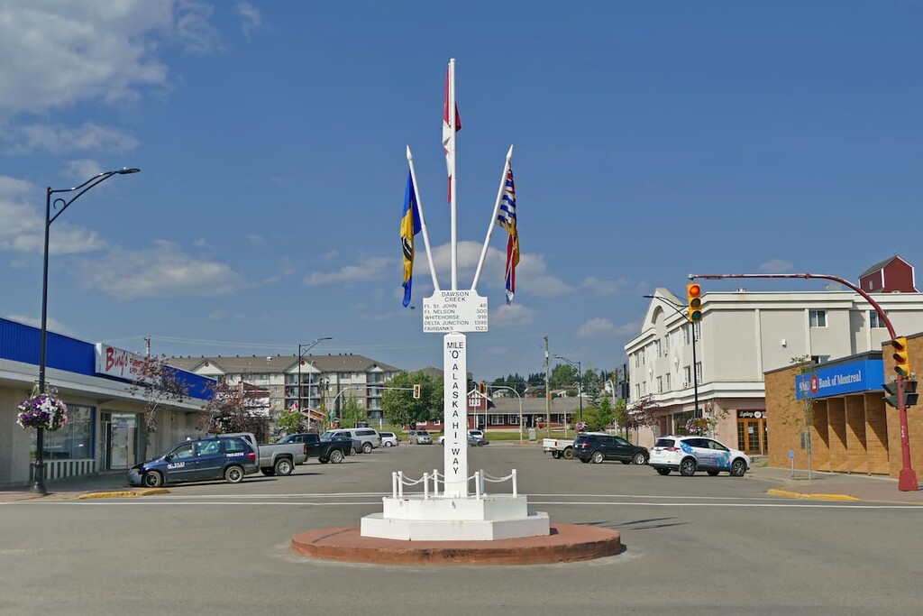
Located about 200 km (120 mi) to the southeast of Bocock Peak Provincial Park, Dawson Creek is a city that was founded in the early twentieth century. Dawson Creek is located at Mile 0 of the Alaska Highway, so it is the gateway to Alaska and the northern wilderness of Canada.
The area surrounding Dawson Creek has beautiful wilderness areas that are great for hiking, skiing, and OHV use. In addition to wilderness access, the city has an art gallery, a historical village, a museum, as well as annual fall fairs and a rodeo.
Some of the popular hikes around the city of Dawson Creek are the casual 1.8 km (1 mi) Leoppky Park Trail and the 9.7 km (5.8 mi) Dawson Creek Trail. There is also a moderate 7.4 km (4.4 mi) hike along the Rim Rocks Trail.
Situated about 50 km (35 mi) to the south of Bocock Peak Provincial Park, Mackenzie is located on the west side of the Hart Ranges off Highway 39, along the shore of Williston Lake. Mackenzie hosts dog sledding, cross country skiing, and snowmobiling competitions, and it is a great place for winter-loving outdoor enthusiasts.
In addition to the 32 km (19 mi) of cross country ski trails that the community keeps groomed throughout the winter, there are many trails nearby that are worth hiking if you’re in the area. Some of the recommended trails are the Morfee Lake Trails, Cut Thumb Falls, and the Kimta Creek Trail.


