Scan the QR code and open PeakVisor on your phone
Graham-Laurier Provincial Park is one of the many remote wilderness parks in the Muskwa Ranges of the Far Northern Rockies of British Columbia, Canada. The park encompasses much of the watershed of the Graham River and a total of 7 named peaks. The tallest and most prominent peak in the park is Mount Laurier, which has an elevation of 2,356 m (7,730 ft) and a prominence of 929 m (3,048 ft).

Covering nearly 1,000 square kilometers (386 square miles) of terrain, Graham-Laurier Provincial Park is located in the Muskwa Ranges of the northern Rockies in British Columbia, Canada. It is situated to the north of the Peace Arm of Williston Lake.
Graham-Laurier Provincial Park has eight peaks, the tallest and most prominent of which is Mount Laurier with 2,356 m (7,730 ft) of elevation and 929 m (3,048 ft) of prominence. Other major features of the park are Lady Laurier Lake and Christina Falls.
Fort St. John is the largest city near the park. It is located approximately 145 km (87 mi) to the southeast of Graham-Laurier Provincial Park. Graham-Laurier Provincial Park is a remote wilderness park and the closest road access is from the Halfway/Graham Forest Service road, which takes visitors within 10 km (6 mi) of the southeast corner of the park.
The geology of Graham-Laurier Provincial Park represents the transition from the Far Northern Rockies through the schist rocks of the Misinchinka Ranges to the Peace Foothills. The formation of the mountains and valleys of the park began with the accumulation of sediment off the coast of ancient North America, about 380 million years ago.
During the Paleozoic, sediments accumulated into layers that were often many kilometers thick. Under pressure, the layers of marine sediment consolidated into the limestone that makes up most of this part of the Rocky Mountains. However, a significant band of mud was deposited along the western side of the region in an area that would eventually become the northern Rockies.
Before the Rockies formed, the layer of mudstone and shale underwent metamorphosis through increased heat and pressure and was transformed into schist. Graham-Laurier Provincial Park’s west side is part of the belt of Misinchinka schist that also makes up the Misinchinka Ranges.
In some instances, schist is more susceptible to erosion than limestone. As such, the peaks formed from Misinchinka schist tend to be more rounded and lower profile than the peaks that are made of limestone. A band of Minischinka schist defines the Misinchinka Ranges and a 200 km (120 mi) section of the western side of the Muskwa Ranges, including the west side of Graham-Laurier Provincial Park.
During the Pleistocene, much of the region that is now part of Graham-Laurier Provincial Park was heavily glaciated. The Rockies were covered by ice during several glacial maximums, the last of which ended about 15,000 years ago.
A near-continuous layer of glacial till that’s found throughout the Muskwa Ranges is one piece of evidence that glaciers once covered these ranges. During this time, the glaciers eroded significant portions of the mountains, especially the parts that were made of the softer Misinchinka schist.
Graham-Laurier Provincial Park is mainly home to distinct alpine and subalpine ecologies; however, there is also a section of old-growth black and white spruce along the Graham River.
The alpine region of Graham-Laurier Provincial Park has barren, rocky peaks, along with alpine meadows and parkland. Here, the vegetation is a mix of heather, grass, and sedge mixed among the rocky outcrops.
However, the alpine gradually transitions from the barren peaks into a parkland-like ecosystem with stands of trees and meadows creating a mosaic. Eventually, it becomes a landscape that’s dominated by dense forests of Engelmann spruce and subalpine fir.
The subalpine forests of Engelmann spruce and subalpine fir are the dominant forests and ecosystem of Graham-Laurier Provincial Park. The park has high-quality habitat for mountain goats and stone sheep who live among the alpine rocky outcrops. It is also home to moose and elk who live in the forests and along the rivers.
Thanks to its abundance of prey, there are many predators in the park, too. This includes wolves, grizzly bears, and black bears. Graham-Laurier Provincial Park is also home to the marten, fisher, weasel, and wolverine.
The rivers, creeks, and lakes of the region provide habitat for several different fish species. Bull trout and slimy sculpin are found in the Graham River, while arctic grayling inhabit Lady Laurier Lake. Rainbow trout also live in Needham Creek. However, Christina Falls creates a natural barrier to fish migration, which has resulted in the creation of a genetically isolated population of fish.
Soon after the end of the last glacial maximum in the region, vegetation, animals, and people began to inhabit the Far Northern Rockies. To the east of Graham-Laurier Provincial Park and to the north of Fort St. John, at Charlie Lake, there are caves that have evidence of human occupation from 10,500 years ago.
Archaeologists have uncovered evidence of various ancient cultures that once inhabited the caves. This evidence includes fluted hunting points, rock flakes, and even evidence of ceremonies and rituals. When Alexander Mackenzie arrived in the region in 1793, he met with members of the Dane-zaa First Nation whose ancestors have lived in the region since time immemorial.
The Dane-zaa traditionally live throughout the Rockies and the prairies to the north of the Peace River. Pre-contact, they lived a life of hunting and gathering by following the migration of animals such as bison.
To help expand the fur trade, Fort St. John was established in 1794. This makes it one of the oldest European settlements in British Columbia. Fort St. John, along with other forts, was established along the Peace River to facilitate the fur trade.
Prior to the construction of the Alaska Highway in 1942, the region was only accessible by horseback, plane, boat, and walking. The Alaska Highway is responsible for the establishment of many of the communities in the region.
The park was established in 1999 to protect the wilderness that surrounds the tributaries of the Graham River.
The major trail and attraction in Graham-Laurier Provincial Park is a 22 km (13 mi) trail to Christina Falls. The trail is accessible to OHV, horses, cyclists, and hikers, and it follows a path through the wilderness. It offers wilderness, lake, and river views as well as the final views of the canyon and Christina Falls.
Backcountry camping is permitted in the park, and while the Christina Falls Trail is the primary trail in the park, there are rough trails along the Graham River, Horn Creek, Needham Creek, and Guilbault Creek. There are also opportunities to canoe or kayak in the rivers and larger creeks.
Graham-Laurier Provincial Park is located in the remote northern Rockies of British Columbia. While there is no direct road access to the park, the following are several of the communities closest to the park from which you can set off on your northern adventures.
Graham-Laurier Provincial Park is situated about 120 km (72 mi) west of Fort St. John. Fort St. John is the largest city in the Peace River Regional District, and it is located at Mile 47 of the Alaska Highway. The community was originally established as a trading post for the fur trade in 1794, a year after Alexander Mackenzie traveled to the region.
The wilderness and mountains that surround Fort St. John have abundant wildlife, scenic landscapes, wild rivers and creeks, trails to follow, and wilderness to explore. The following are several of the attractions and trails around the city: the Charlie Lake Caves have evidence of human inhabitants from 10,500 years ago, as well as trails such as Willow Loop, Cactus Trails, and the Cecil Lake Highway Trail Loop. From the trails, there is a vast northern wilderness to explore.
Dawson Creek is located about 250 km (150 mi) to the southeast of Graham-Laurier Provincial Park. Established in the early twentieth century, Dawson Creek is located at Mile 0 of the Alaska Highway and is the gateway to Alaska and the northern wilderness of Canada.
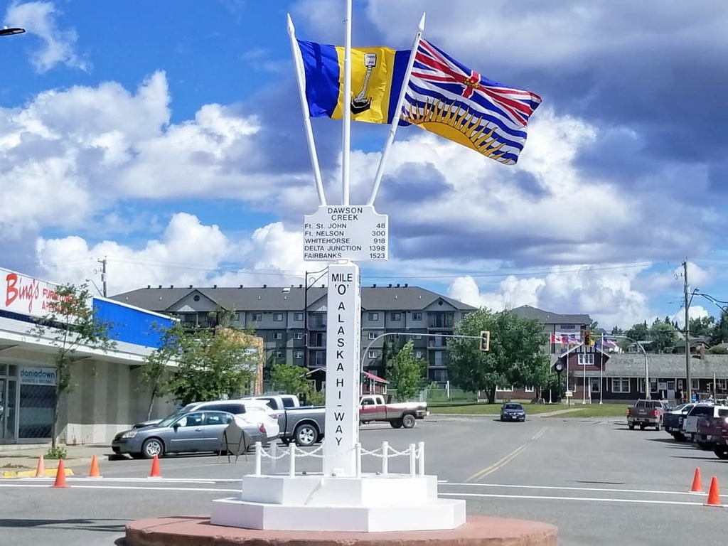
Some of the popular hikes around the city of Dawson Creek are the casual 1.8 km (1 mi) Loeppky Park Trail and the 9.7 km (5.8 mi) Dawson Creek Trail. There is also a moderate 7.4 km (4.4 mi) hike along the Rim Rocks Trail.
The region surrounding Dawson Creek has beautiful wilderness areas that are great for hiking, skiing, and OHV use. In addition to wilderness access, the city has an art gallery, a historical village, a museum, as well as annual fall fairs and a rodeo.
Situated about 150 km (90 mi) due south of Graham-Laurier Provincial Park, Mackenzie is a community located on the west side of the Hart Ranges off Highway 39 and along the shore of Williston Lake. Mackenzie hosts dog sledding, cross country skiing, and snowmobiling competitions, and it is a great place for winter-loving outdoor enthusiasts.
Some of the nearby hiking trails include Morfee Lake Trails, Cut Thumb Falls, and the Kimta Creek Trail. The town also grooms 32 km (19 mi) of cross-country ski trails throughout the winter for locals and visitors to enjoy.