
Scan the QR code and open PeakVisor on your phone
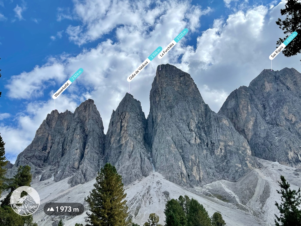
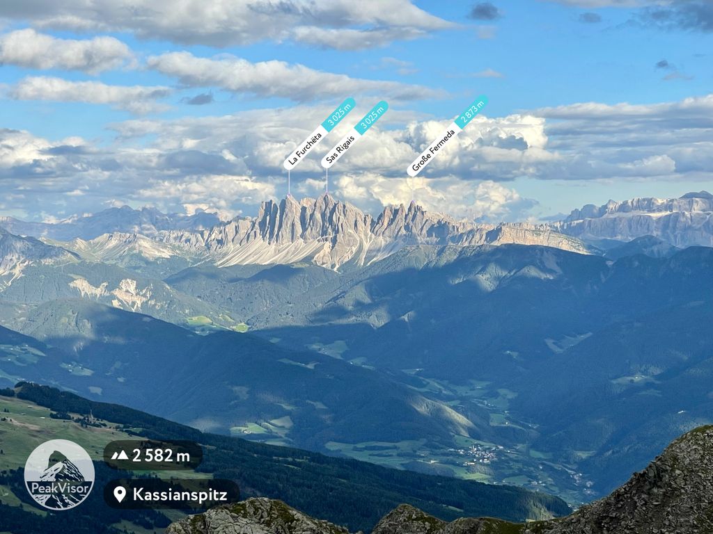
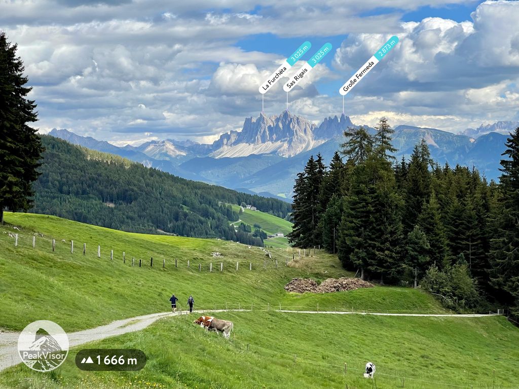
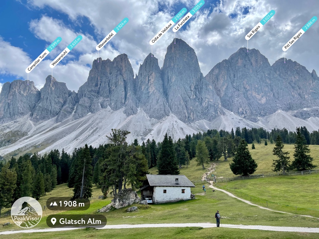
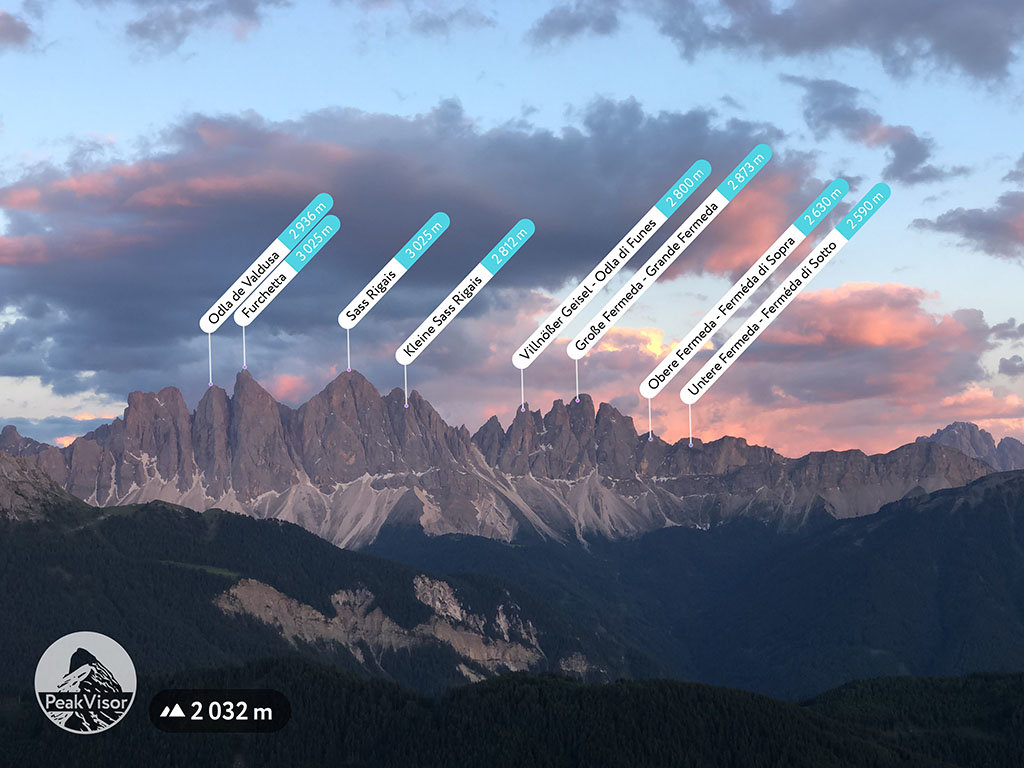
The Odle Group include 39 named peaks. The highest is La Furchёta at 3,025 m. Other notable peaks include Sas Rigais, Torkofel and Odla de Valdusa.
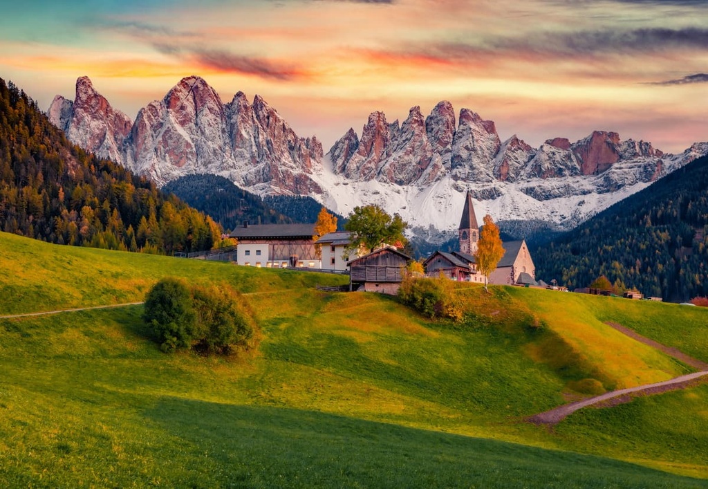
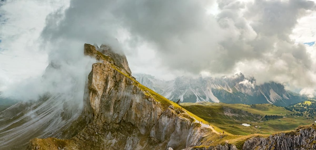
The Odle Group is a relatively small mountain chain located in the Dolomites of northern Italy. Alongside the Puez and Peitlerkofel groups, it is part of the Puez-Odle Nature Park. The main feature of the Gruppo del Odle its steep and rugged peaks, the most memorable of which is Secёda (2,519 m / 8,264 ft). There are 39 named mountains in Geislergruppe. The highest and the most prominent mountain is La Furchёta (3,025 m / 9,925 ft).
The name of the Odle Group (Gruppo del Odle / Geislergruppe) means “needles” in the language of Ladins, the major ethnic group that historically lives in the five valleys at the center of the Dolomites.
The Ladins likely gave the group this name simply because the group’s major peaks look like a row of needles. In fact, they look so much like needles that it appears that you could use these peaks to sew up your hiking boots that are ten years old, but that you love and don’t want to throw away.
The Odle Group is one of the westernmost and northernmost groups in the Dolomites. It is located in the West Dolomites subregion in the province of South Tyrol in the Trentino-Alto Adige / Sudtirol region in Italy.
The exact boundaries of the group are clearly defined by three large valleys:
But these are not the only mountains in the area. Gruppo del Odle also neighbors the Peitlerkofel Group to the north, as well as both the Schlern Group and the Langkofel to the south.
Administratively, the group belongs to the Gardena Valley with two major municipalities: Ortisei / Urtijëi / Sankt Ulrich and Chiusa / Klausen.
You can get to these towns from Bolzano in about 40 min (36.3 km / 22.5 mi) by car. If you want to travel by public transport, use the Suedtirol Mobil buses.
In geological terms, the Odle Group, together with the Puez and Peitlerkofel, is also part of one of the nine major mountain systems in the Dolomites called Puetz-Odle, whose territory almost entirely coincides with that of its namesake nature park.
The main mineral in this group is the same as in the other eight groups in the Dolomites: dolomite. This rock was named after the French explorer Déodat Gratet de Dolomieu. Dolomite began to form 200–230 years ago in the Triassic period as sediments began to collect on the bottom of the tropical Tethys Ocean.
However, from other systems in the Dolomites, the Puetz-Odle System is notable because it contains a diversity of geological layers and minerals. For example, in addition to Principle Dolomite, the main type of this mineral, there are a number of other varieties such as Sarl / Serla Dolomite and Schlern / Sciliar Dolomite that you can see in the Odle Group.
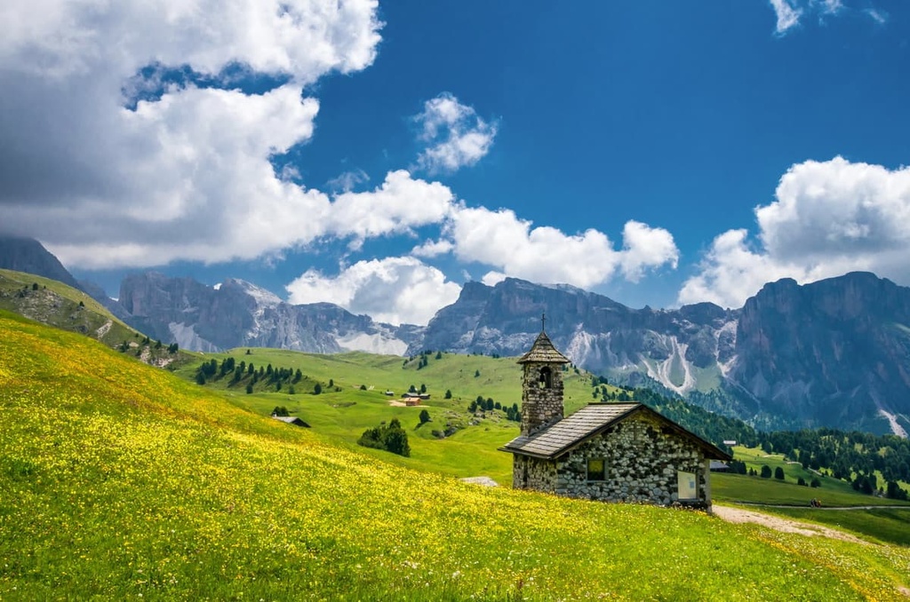
In addition to the peaks, passes, and neighboring groups, another great feature of the Odle landscape is Flitzer Waterfall (Flitzer Wasserfall / Cascata di Valluzza). This waterfall is 45 meters (148 feet) high, and it is located in the western part of the Funes Valley.
That said, the waterfall isn’t a very popular natural attraction, but it is very beautiful. Each spring, with the melting of the snow, is particularly fascinating for its abundant amount of water.
There is an easy path to the falls, Trail #29A, which departs from the nearby villages of Masi della Volpe or Pardell. The trail is casual and family-friendly.
What you also might not expect from the Odle Group are moon-like landscapes like this: large empty spaces with barely distinguishable figures of other people. But they are there. The Odle mountains have a few surprises in store for you, even if you've studied it in great detail from photos and guides like this one in PeakVisor.

The Gruppo del Odle is one of the dozens of groups that make up the Dolomites in the Southern Limestone Alps in the Classification of the Eastern Alps by the German and Austrian Alpine Club. This classification system is also known by the acronym AVE.
By this classification, the Dolomites, in turn, are one of the 75 groups in the Eastern Alps, alongside the Carnic Alps, Fiemme Mountains, and Sobretta-Gavia, among others.
According to another popular classification system, the Italian SOIUSA (Suddivisione Orografica Internazionale Unificata del Sistema Alpino or International Unified Orographic Division of the Alpine System), the Odle Group is also a separate group within the Dolomiti di Gardena supergroup.
This group is part of the subsection Dolomiti di Gardena e di Fassa of the section Dolomiti in the large sector Alpi Sud-orientali (Southeastern Alps) in the Alpi Orientali (Eastern Alps).
Furthermore, the Dolomiti di Gardena can be divided into the following two subgroups:
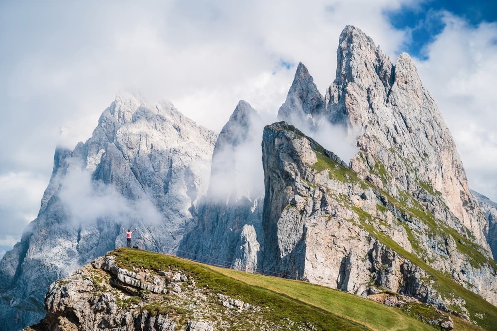
Up next, we’ll briefly discuss some of the most important peaks in the Odle Group. Thankfully, the group makes things easy for us, as nearly all of its main needle-like peaks are lined up one after another in a single long line with impressive north faces that stand over 1,000 m (3,280 feet) high.
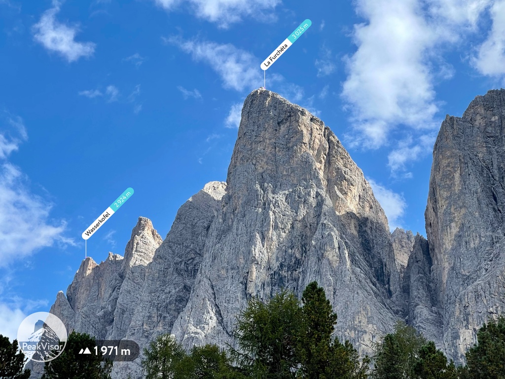
La Furchёta (3,025 m / 9,925 ft) is the highest peak of the Odle Group and one of the most famous. The first climber who reached the summit was a local from Val Gardena named Johann Baptist Vinatzer who made the first ascent on July 27, 1870.
However, the north face of La Furchëta was one of the biggest challenges in twentieth century mountaineering. The mountain’s north face was first climbed on August 1, 1925, by Emil Solleder and Fritz Wiessner.
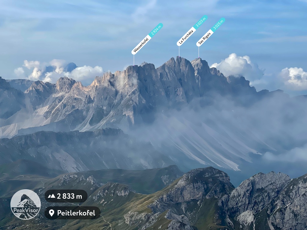
Sass Rigais (3,025 m / 9,924 ft) is the second highest mountain of the Odle Group. It is located to the east of the first one, as seen from the Funes Valley.
The northwest face of Sass Rigais was first climbed in 1901 by Viktor Wolf von Glanvell and Günther von Saar. However, the other sides of the peak were climbed before in 1878 (from the west) and 1888 (from the east). There is a famous via ferrata leading to the summit, too, that’s worth checking out for experienced hikers.
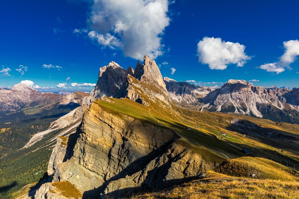
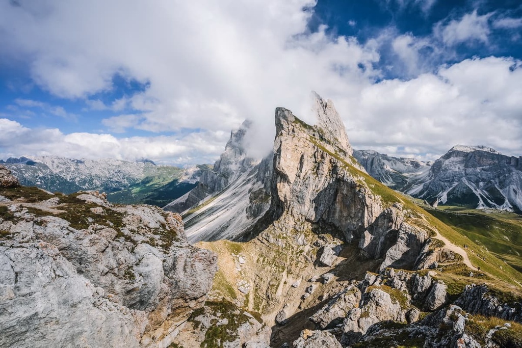
Secёda (2,519 m / 8,264 ft) is the most unusual and best-known peak of the Odle Group. It is so well known because it boasts beautiful scenery and excellent views of the other peaks in the region.
The Secёda itself is a mountain with a meadow-like summit with a gentle slope, which you can easily reach with a cable car from Val Gardena. However, this flatness is deceptive—on the other side, the peak drops off with a high wall just like the other peaks of the group.
Another interesting must-know fact about the peak is that since 1997, at the end of the winter season, there is a famous one-day ski race called Südtirol Gardenissima that takes place directly from the summit of the mountain to Val Gardena.
This is the longest giant slalom in the world with 6 kilometers (3.7 miles) of skiing and an elevation difference of 1,033 m (3,389 ft). The number of participants in the race is limited to 650 people, but the race is open to everybody, including both professionals and amateurs of all ages. So, you have a chance to participate in it, too, if you apply for the race way in advance.
The Odle Group offers hikers and climbers a huge variety of trails of varying lengths and levels of difficulty to choose from. Here are some of the best hikes in the Odle Group to check out.
The Adolf Munkel Trail (Via delle Odle) is a famous nature trail in the Odle Group that is located in the heart of the Puez-Odle nature park in the Funes Valley. This trail allows you to get to know the region’s flora (and possibly fauna). It also provides perhaps the best view of the peaks of the Geislergruppe and the neighboring mountains.
The route begins at the parking lot in the village of Zans at an elevation of (1,685 m / 5,528 ft). You can reach the trailhead by bus from Brixen.
From here, the trail travels in the direction of Tschantschenon and Brogles Mountain Hut (Brogleshütte / Rifugio Malga Brogles) at 2,045 m (6,709 ft). Then it goes to the Church of St. John in Ranui (Chiesa di San Giovanni in Ranui), which is another beautiful church in the valley.
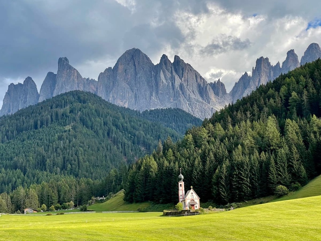
The church features a Baroque chapel with a copper-domed bell tower and facade decorated by frescos. It is a part of the Ranui Hof property, one of the most ancient farmsteads and hunting lodges in Val di Funes of the local noble Gufidaun family dating back to 1370.
The name Ranui comes from the phrase "hofze Rumenuye und wise heizzet Tschuval." In 1665, the lodge was bought by a South Tyrolean innkeeper and trader named Michael Jenner (1637–1723). Then, thanks to his family's hospitality, it became a popular meeting point for hunters and other visitors.
In addition to Brogles Mountain Hut and Ranui Hof farm on the trail, you will also see at least three other traditional Alpine huts, which are as much the attractions of the Odle Group and the Puez-Odle Nature Park as the surrounding majestic mountains:
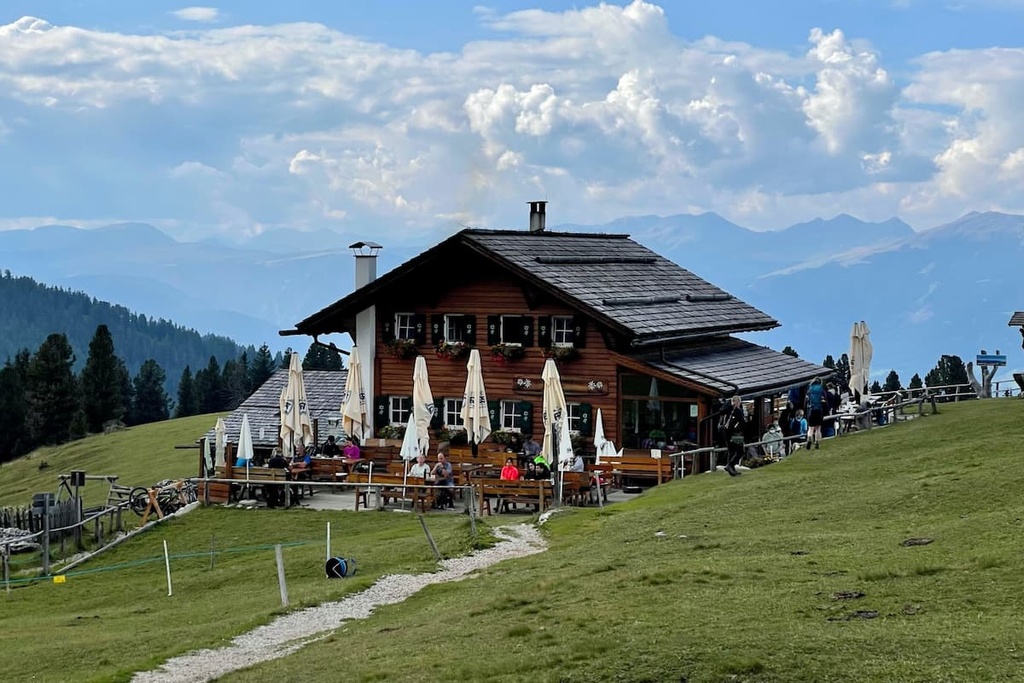
Geisler-Alm / Rifugio delle Odle (1,996 m / 6,548 ft), which is built entirely of wood, operates as a restaurant (no overnight stay) despite the word rifugio in the name. It also offers hiking excursions for groups of up to 50 people on the Adolf Munkel Trail during the summer tourist season. They are best booked in advance.
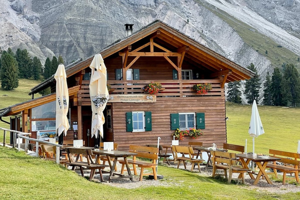
Gschnagenhardt-Alm / Malga Casnago (2,006 m / 6,581 ft) is slightly smaller, also a wooden hut, located a few dozen meters (feet) from the previous one, but it works on the same principle as a restaurant only. The hut is led by the local Profanter family, who will cook for you their famous South Tyrolean bacon and cheese, “Schlutzkrapfen” / Mezzelune — a stuffed pasta, similar to Italian ravioli, and dumplings in all their variations, and other dishes.
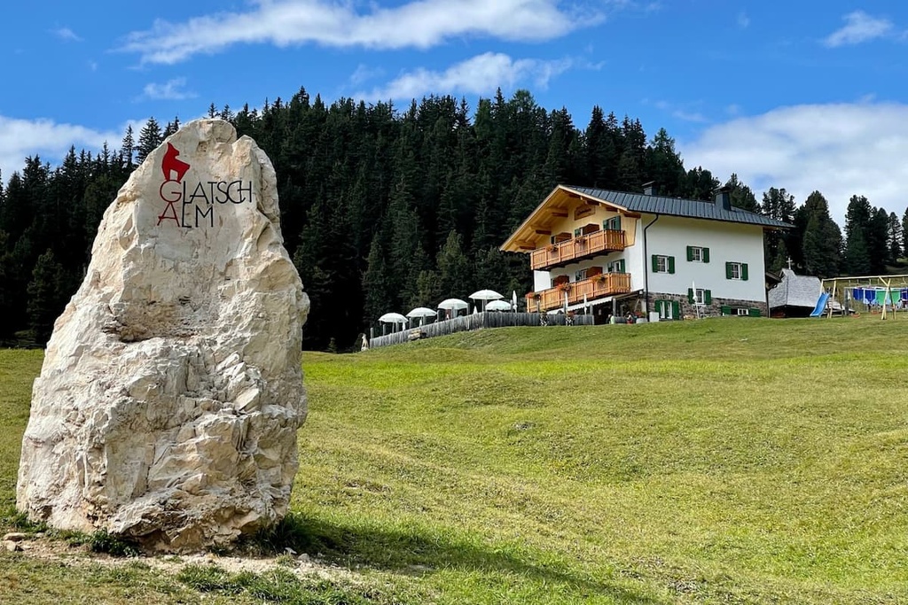
Glatsch-alm / Berggasthof (1,902 m / 6,240 ft) is a white two-story stone building with wooden roof and balconies a little away from the previous two. In this hut, you can not only eat but also stay overnight during the summer season in double rooms and dormitories. For example, a double room with breakfast in the season's beginning between June 2 and June 30 costs €50,00 per person for a minimum stay of three nights.
There is also a shorter circular hike along Trail #35 that takes you to rifugio Odle / Geisleralm. It then takes you to Dusleralm hut and back to Zans for a total length of 9 km / 5.5 mi (about 3 hours of walking).
This is another very famous route to Secёda that features incredible panoramic views of the main peaks of Odle.
In particular, you can see the peak Fermeda, and its many summits: Große Fermeda (2,873 m / 9,425 ft), Kleine Fermeda (2,780 m / 9,121 ft), Untere Fermeda (2,590 m / 8,497 ft), Obere Fermeda (2,630 m / 8,629 ft). According to PeakVisor’s founder, this trail leads to “really one of the most photographed locations in the Dolomites (and it is totally worth it)."
The trail can have two starting and finishing points: the Ortisei-Furnes-Seceda cable car top station from Ortisei or Col Raiser cable car top station from Selva di Val Gardena.
The exact route is:
One of the features of the route is the Mastlé Col Raiser viewing platform next to the Mastlé Pastures and Col Raiser cable car top station at 2,200 m (7,283 ft). It is one of the several so-called "panoramic balconies of the Dolomites" that was installed by UNESCO in different parts of the region. The platform was created by the local Messner Architects Studio.
This is a via ferrata to the second highest peak of the group, Sass Rigais, which is suitable for fans of this type of straightforward climbing that find themselves in Odle for the first time. However, before embarking on this adventure, you should have experience in via ferratas. You should also have all the special equipment, which consists of carabiners, ropes, helmet, and gloves.
The trail to the summit starts where many of the hiking trails in the group do, at Col Raiser cable car top station.
From there you head toward rifugio Firenze and the summit of Col de la Crusc (2,490 m / 8,169 ft), at the foot of which at the fork turn left. Then follow the ferrata to Sass Rigais.
From the summit, you will descend in the direction of Sass Mesdi (2,762 m / 9,061 ft) and return to the fork in the trail. Follow the parallel trail to Malga Pieralongia Alm, back to the cable car to make a larger circle.
The ferrata itself is generally of medium difficulty, but the ascent to the summit itself is quite long and difficult.
For skiing and snowboarding enthusiasts, the Gruppo del Odle is of particular interest because it is located in the Gardena Valley, one of the two largest ski areas in the Dolomites, on par with the Badia Valley.
Both of these ski areas are part of the Dolomiti Superski system. In fact, here there are so many trails that it is sometimes difficult to count them all.
There are several main ski areas in Val Gardena Ski Resort:
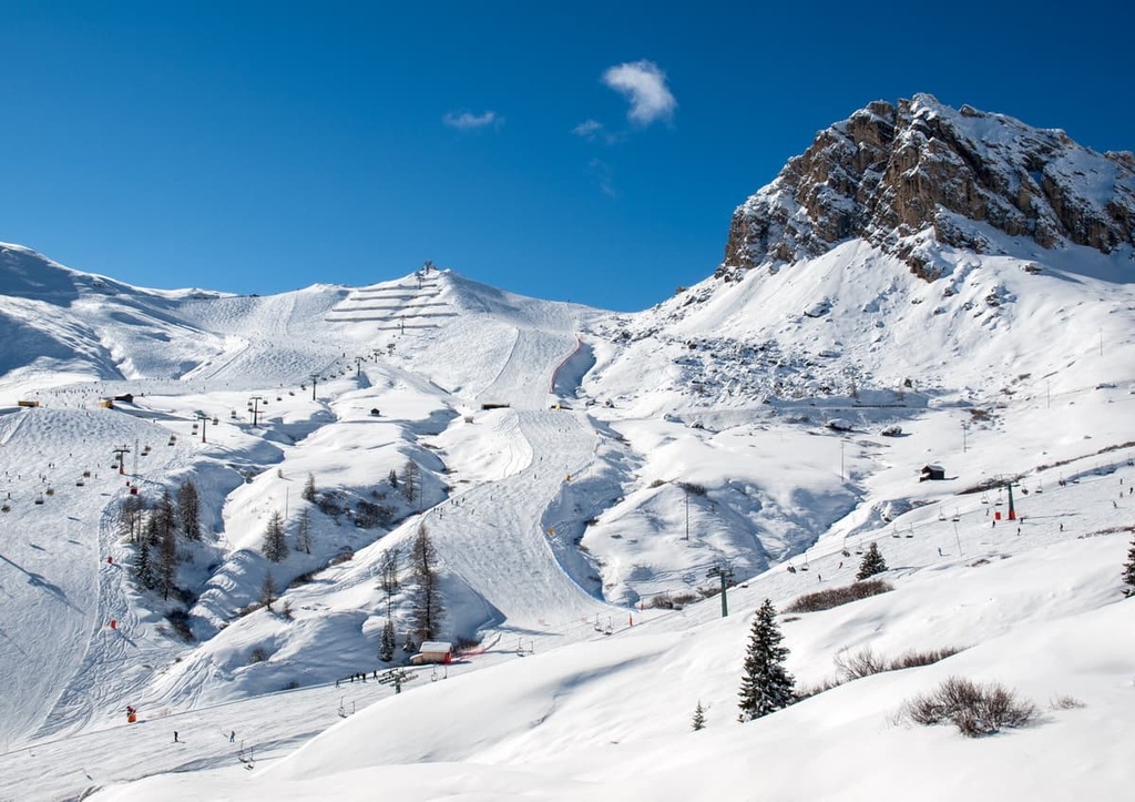
In total, there are 178 km (110.6 mi) of trails in the Val Gardena Ski Resort. In particular, 52 km (32.3 mi) of blue, 105 km (65.2 mi) of red, and 21 km (13 mi) of black trails.
The resort is more suitable for advanced and professional skiers than for first-timers. There are more than 79 lifts that take you up the slopes of the resort between a minimum resort elevation of 1,236 m (4,055 ft) and a maximum of 2,518 m (8,261 ft) with a total vert of 1,282 m (4,206 ft).
The trails are connected to the resorts in the groups of Sella, Langkofel / Sassoulngo, Schlern-Rosengarten / Sciliar-Catinaccio. This means that there are even more trails to discover for the keen adventurer.
The season at Val Gardena usually starts in mid-December and lasts until mid-April like everywhere in the Dolomites. Lifts and slopes opening times: 8:30 am to 4:30 pm.
Check the Odle ski map on the larger Trentino-Alto Adige/Südtirol and Italy ski maps in the World Mountain Lifts section of the site. It includes information about open ski lifts / slopes in the Odle Group of the Dolomites in real-time with opening dates and hours. There are also year-round cable cars, funiculars, cog railways, aerial tramways, and all other types of mountain lifts.
Before you start your hikes in the Odle Group, be sure to stop by the official tourist center of the Gardena Valley, which is located in the town of Ortisei. There, you can pick up a paper map of the valley and the surrounding area, as well as guidebooks, books about this part of the Dolomites that are not for sale anywhere else.
However, you’d better go back to the center for books on your way back, or else you’ll add a couple of extra kilos to the weight of your already too-heavy backpack. If you hike mountains, you know for yourself that even an extra kilo on demanding high elevation and long-distance hikes is always a struggle.
Tourist Association Ortisei
Via Rezia, 1, 39046, Ortisei, Val Gardena, BZ, Italy
+390471777600
General summer opening times:
From mid-April to mid-May and in November, the office is closed on Saturday afternoon and on Sundays
The Geislergruppe doesn’t have as many rifugios, the classic type of temporary overnight accommodation during multi-day hikes at high altitudes in the Dolomites, as the neighboring Puetz Group or other places in the region.
However, there are four such huts in the group. They all operate on a "shared room and half-board (dinner and breakfast)" system, just like other similar huts. These rifugios include:
The first hut on the list, the Juac-Hütte, deserves a special mention for its unusual modern design. It is a small two-story building built half in stone and the wood—very different from anything I have seen in the Dolomites.
The first building was built in 1966 by a local family named Comploi, who still run it today. But it was rebuilt a few years ago, as is the case with many rifugios. They are changing toward more modern designs, which, I think, might help with tourism in the future.
The rifugio is situated above Selva di Val Gardena / Wolkenstein in Gröden in the beautiful alpine meadow Prà da Tieja, at 1,905 m (6,250 ft) with wonderful views of the Odle and Sella groups. It is open in both summer and winter thanks to the presence of ski slopes.
The Juac Hut has one large dormitory room for 16 people and one room for four people, so there are 20 beds. Prices are between €50–60 in summer with breakfast (no dinner), and €70–80 in winter with half-board (dinner included). Credit cards are accepted.
Ortisei or Sankt Ulrich in Gröden (in German) or Urtijëi (in Ladin) is the main and largest village in the Val Gardena Valley. It is located on the southern borders of the Odle Group at an elevation of 1,220 m (4,002 ft).
The town is known primarily as a center for tourism and recreation, whose history here dates back to around the nineteenth century. It is also known for the art of local craftsmen who create all kinds of carved wooden sculptures that are handed down from generation to generation to this day. Ortisei is home to 4,823 people (2020).
The main architectural and cultural attractions of the village are:
The village is one of the main ski centers of the Dolomites. It is also part of the aforementioned Dolomiti Superski system.
Check out the official tourist site for more information: Valgardena.it.


The highest peak in the Odle Group is La Furchёta, at 3,025 m.
The Odle Group have 39 named peaks.


