
Scan the QR code and open PeakVisor on your phone
The Genevieve Range include 1 named peak. The highest is Hixson Bluff at 29 m.
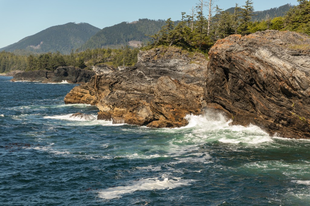
The Genevieve Range is a small mountain range on the northwest edge of Nootka Island, which is off the Coast of Vancouver Island in British Columbia, Canada. Nootka Island holds the historic site where Captain James Cook made landfall in 1778.
There are several unnamed peaks in the Genevieve Range with the tallest rising about 765 m (2,500 ft) above sea level; however, the only named feature in the range is the 29 m (95 ft) tall Hixson Bluff which is on the northside of the island, overlooking Nuchatlitz Inlet
Located off the west coast of Vancouver Island in British Columbia, Canada, the Genevieve Range covers about 101 square kilometers (39 square miles) of Nootka Island. The range overlooks the Nuchatlitz Inlet from the south and across the inlet is the Sophia Range which covers the northern peninsula of the island.
Access to the Genevieve Range typically starts with the trip to Nootka Island by ferry, floatplane, or a chartered boat. Unless a plane or boat is chartered most people travel from the community of Gold River on Vancouver Island to Yuquot (Friendly Cove) on Nootka Island.
The Genevieve Range is situated on the remote and rugged west coast of the province and can be reached by floatplane, water taxi, or via the Nootka Island Trail. Hixson Bluff (29 m/ 95 ft) is the only officially named feature in the range; however, there are several unnamed peaks in the range, the tallest of which is about 765 m (2,500 ft) tall.
Nuchatlitz Provincial Park is north of the Genevieve Range, across the inlet and the following are some of the other nearby parks and recreation areas:

The Genevieve Range is one of the western subranges of Vancouver Island Ranges of the Insular Mountains. The Insular Mountains are west of the Canadian Coast Mountains and include the west coast islands, with the most commanding features of the Insular Mountains being the Vancouver Island Ranges and the mountains of Haida Gwaii.
The Vancouver Island Ranges formed during the Cretaceous when a group of volcanic islands (the Insular Islands) collided with the coast of British Columbia. Turbidites, basaltic lava, and pillow lavas are among the most common types of rock that make up the ranges on Vancouver Island. Unlike the Coast Mountains, granitic plutons are uncommon on Vancouver Island.
During the Pleistocene nearly all of Vancouver Island was covered with glaciers. Glaciers formed among the highest peaks along the spine of the island and flowed down to the ocean sharpening the valley walls and eroding their bottoms. Once the sea level rose again, these valleys filled with water to become the vast fjords along the west coast of Vancouver Island.
Temperate rainforests dominate the west coast, where old growth forests may be hundreds of years old on Nootka Island. These forests are representative of the Coastal Western Hemlock ecosystem of British Columbia.
Western hemlock, Pacific silver fir, western red cedar, and big leaf maple are the most abundant species found in the Genevieve Range. Sitka spruce are also present in the range, as they have adapted to withstand the salty air and salt spray from the ocean, and they typically dominate the shoreline of the island.
Due to easy accessibility from the ocean, significant tracts of the old-growth forest in the region have been logged since the nineteenth century. Many of the forests along the west coast of Vancouver Island were the first to be logged because the trees were easily taken down to the ocean for transport to mills and logging continues in the Genevieve Range and adjacent forests.
The low elevation of the Genevieve Range has prevented any alpine areas from forming and the peaks of the range are all covered with dense forests. These forests are filled with a variety of species representative of Vancouver Island, such as black bears, golden eagles, bald eagles, gray wolves, and Columbia black-tailed deer.
The oceans adjacent to the Genevieve Range are inhabited by gray whales, orcas, dolphins, porpoises, sea lions, and sea otters.

During the eighteenth and nineteenth centuries, sea otters in the region were hunted to near extinction due to the lucrative trade of their pelt. Fortunately, due to conservation efforts, sea otters are making a return to the area.
That there are any sea otters at all along the west coast of Vancouver Island is owed to conservation efforts in the mid twentieth century when sea otter colonies were successfully relocated from Alaska.
The Genevieve Range is on Nootka Island which is the traditional territory of the Nuu-chah-nulth First Nations. The name “Nootka” for which the island and the sound were named, comes from a derivation of the name of the Nuu-chah-nulth.
Spanish explorers were the first to set anchor along Nootka island and the first recorded landfall on Nootka Island and Vancouver Island by a European was made by Captain Cook as he sailed the Pacific Northwest in search of the fabled Northwest Passage.
Shortly after the arrival of Captain Cook in the Nootka Sound in 1778, long standing tensions between the British and the Spanish nearly caused a war. The area has an extensive history that includes disputes between the Spanish and British for control of the region as well as disputes between Europeans and the Nuu-chah-nulth.
The southern end of Nootka Island is home to the community of Yuquot, along the shores of Nootka Sound. It is believed that Yuquot has been inhabited for about 4,300 years by the Nuu-chah-nulth. The current community surrounds a lighthouse; however, it was also the location of the only Spanish settlement in Canada, as well as the location of caves with Indigenous and Spanish burial sites.
While Yuquot became one of the last Nuu-chah-nulth communities on Nootka Island, historically there were many villages and campsites across the island. Some of the archaeological sites near the Genevieve Range include culturally modified trees, village sites, seashell middens, fish traps, and orchards.
Indeed, recent archaeological studies have emphasized the importance of food cultivation for the Nuu-chah-nulth people. While typically regarded as “hunter-gatherers” and “non-agricultural”, the Nuu-chah-nulth practiced plant husbandry and cultivation.

Within or adjacent to most village sites, archaeologists are discovering evidence of orchards and forest gardens. While it was overlooked at the time, in 1792, Archibald Menzies, who was Captain George Vancouver’s surgeon and naturalist, noted intensive cultivation of root crops in the intertidal zones. The intertidal root gardens were managed to encourage “wild” root crops like Pacific silverweed, rice root lily, and springbank clover.
Inland gardens and orchards have been discovered that contain Pacific crabapple trees and other plants such as blueberries, salmonberries, salal, camas, and red elderberry. The management and cultivation of the forest gardens were an important part of the sustenance and economy of the local indigenous people.
It is estimated that when Captain Cook arrived the Nuu-chah-nulth was between 12,000 and 30,000 strong. In 1884, after a century of introduced turmoil and epidemics, the first reliable census of the Nuu-chah-nulth estimates a population of only 3,500, which was reduced to 1,605 by 1939.
Since the decline of the fur trade, forestry has been the major industry to affect the Genevieve Range and Nootka Island. There are no communities on the west side of the island; however, there are logging roads that enter the range and the Nootka Trail which runs along the west coast of the island.
Located on the northwest coast of Nootka Island, the Genevieve Range is a remote wilderness destination. There are some logging roads that penetrate the range; however, there are no official trails through the range and any visitors will need to be able to successfully navigate the backcountry on their own.
There are some logging roads that reach into the Genevieve Range; however, backcountry navigation skills are essential to safe travel through the range. There are no official trails in the range and backcountry camping is allowed throughout the range.
Visitors to the range typically arrive by boat or by hiking the Nootka Trail. Kayaking along the coastline of Nootka Island is a popular way to immerse oneself in the stunning west coast wilderness and there are many resources that show places to explore and camp while kayaking around the Genevieve Range.
The Nootka Trail is 36 km (21.6 mi) long and follows the west coast of Nootka Island. This remote trail should only be tackled by experienced backpackers who are prepared for potentially rough weather.

The trail traverses the coast between Louie Bay on the north side of the island and Yuquot on the south side of Nootka Island winding through the forests and along the beach. The terrain is similar to the West Coast Trail; however, due to fewer visitors and less maintenance, the Nootka Trail is considered more rugged.
Some of the highlights of the trail are the Calvin Creek Waterfalls, swimming in the Pacific Ocean, beachcombing, and the ancient First Nations middens. While hiking along the beached adjacent to the Genevieve Range, you shouldn’t be surprised to find wolf tracks and hint of other wildlife upon the beaches.
Nootka Island is the largest of the islands that are located off the west coast of Vancouver Island and there are several access points to the island via water taxi and float plane. The following are some of the major communities on Nootka and Vancouver Island from where visitors can explore the Genevieve Range:
Gold River is located in the geographic center of Vancouver Island and developed as a typical community that was reliant upon logging and a pulp and paper mill. With changing economic pressures, the mill closed and many people relocated; however, those that remained enjoy living among the picturesque mountains, lakes, rivers, ocean, and forests of the west coast.
Tourism is a major industry in the community and there are companies and guides who promote sport fishing and other wilderness pursuits. Gold River is the closest village to the historic Yuquot, or Friendly Cove, where Captain James Cook made landfall, and there are charter boats and ferry services between the communities.

Once visitors arrive in Yuquot from Gold River, they can hike through the wilderness, kayak along the coast, or take a tour and look for wildlife.
Gold River serves as a base for hiking the Nootka Island Trail and the Elk Lake Trail, as well as for expeditions upon Golden Hinde, the island's tallest mountain, and other climbing areas in Strathcona Provincial Park.
The gateway to the many adventures on northern Vancouver Island, Campbell River has many great places to stay, fantastic places to eat, and some incredible beaches for relaxation. The city is located on the eastside of Vancouver Island, about 120 km (72 mi) from Nootka Island and the Genevieve Range.
Campbell River is connected to the east of Vancouver Island via Highway 19, and the west via Highway 28, Campbell River is the jumping point for wilderness adventures on the north end of Vancouver Island.
While in town, visitors can hike the historic Ripple Rock trail or travel to the nearby Horne Lake and Upana Caves. Mountain bike and hiking trails are only minutes from the main street and they lead along the beach, rivers, or through the beautiful forests around town.
Nearby is Elk Falls Provincial Park, where there are several vantage points to see the stunning Elk Falls, including a suspension bridge that spans the canyon. Strathcona Provincial Park, Quadra and Cortes Islands, Mount Arrowsmith Massif Regional Park, Schoen Lake Provincial Park, and Miracle Beach Provincial Park are some of the other hiking and biking areas near Campbell River.


The highest peak in the Genevieve Range is Hixson Bluff, at 29 m.
The Genevieve Range have 1 named peak.


