Scan the QR code and open PeakVisor on your phone
The San Juan National Forest (SJNF), located in southwest Colorado, is the second largest national forest in the state, comprising 1,878,846 acres or 2,936 square miles. President Theodore Roosevelt created it by proclamation on June 3, 1905. The headquarters is located in Durango, with ranger district offices in the towns of Bayfield, Dolores and Pagosa Springs. The SJNF encompasses a large swath of the majestic San Juan Mountains and includes some of the highest and most iconic peaks in Colorado. The SJNF is named after the San Juan River (Rio San Juan in Spanish) which in turn was named after Saint John the Baptist (San Juan Bautista).
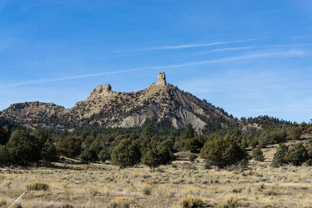
This forest is truly one of the great playgrounds in Colorado – for locals as much as for visitors, many from faraway places. There are four designated wilderness areas, partly or entirely located within the forest boundaries – Lizard Head (also partly in Uncompahgre NF), South San Juan and Weminuche (both also in Rio Grande NF), and Hermosa Creek (entirely in San Juan NF). Also, on September 21, 2012, President Barack Obama designated a part of SJNF as Chimney Rock National Monument by proclamation. The SJNF extends across ten counties and borders on the Uncompahgre NF to the north and the Rio Grande NF to the east.
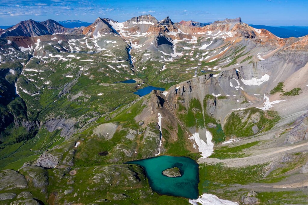
There are 326 named mountains in San Juan National Forest. The highest and the most prominent is Mount Wilson. These include five fourteeners, one in the San Miguel Mountains (also the Lizard Head Wilderness) west of Telluride and the other four in the Needle Mountains (also the Weminuche Wilderness) north of Durango, which are among the most popular ones in the state, even though they are not among the highest ones. It should be noted that two of these fourteeners (North Eolus and El Diente) are not “official” fourteeners because they do not meet the 300-foot prominence criterion. Of the 58 named summits over 14,000 feet in Colorado, there are five with this “unofficial” designation. But who cares, they are still fourteeners. This many significant peaks from which to choose, scattered all over the forest, means that there is no shortage of fine places to go hiking in this large expanse. The only dilemma remains where to choose to go for a hike – or many hikes. We’ll get into that soon enough, but first let’s look at what else there is to do in and near the San Juan National Forest when visiting this wonderful area of Colorado.
The San Juan National Forest covers most of the southern half of the San Juan Mountains west of the Continental Divide. At the east end, the forest begins near the Continental Divide and Wolf Creek Pass and the headwaters of the San Juan River, from where it extends westward almost to the Utah state line. On the south side, the SJNF begins roughly at the latitude of Durango and reaches almost as far north as Telluride, skirting just past Silverton where it encompasses some of the finest mountain hiking nearby. Included within its limits are such outstanding hiking areas as the Needles Mountains and the La Plata Mountains, as well as the Piedra Special Management Area and a significant proportion of the Weminuche Wilderness Area, the largest in Colorado. And let’s not forget the Chimney Rock National Monument.
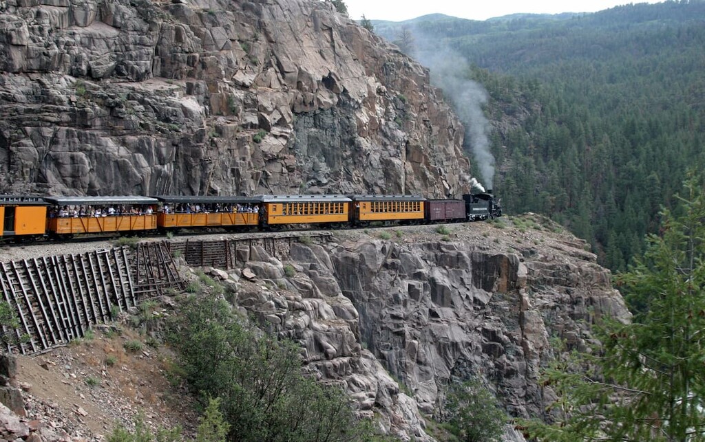
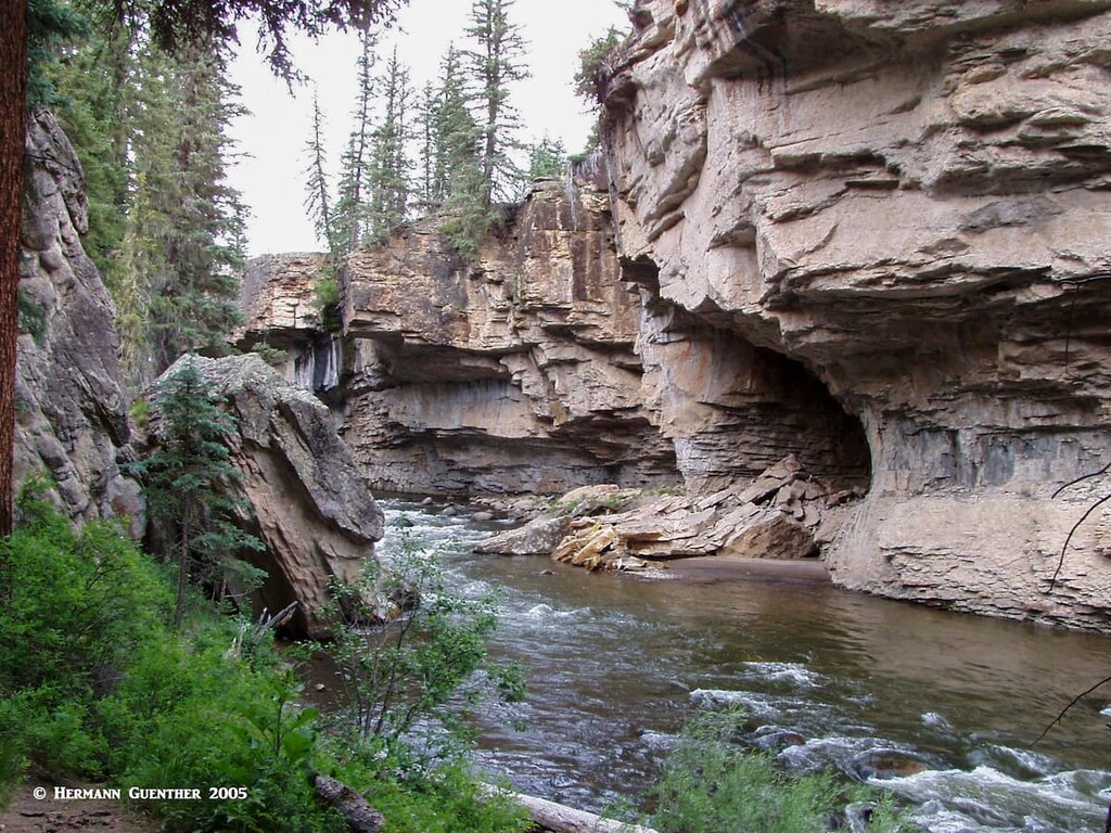
Who has not heard of the Silverton and Durango Narrow Gauge Railroad? It’s just one of the most popular tourist attractions in Colorado, and most of it is within forest boundaries. Only a very short section of it is not in the forest, but you won’t notice the difference as the train leaves the forest – the scenery remains just as spectacular. The train ride along the gorge of the Animas River is one you will never forget. With tracks perched on impossible ledges cut out of vertical cliffs, you may even find yourself getting just a little bit nervous.
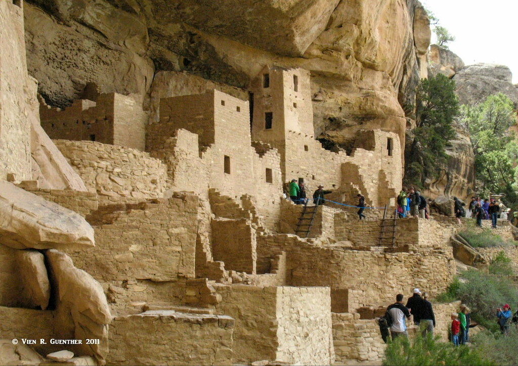
Do you want to see a national park while visiting here? Mesa Verde National Park may not be in or right next to the SJNF, but it’s in the neighborhood and you can see one from the other. This UNESCO World Heritage Site is the largest archaeological preserve in the United States. None other than President Theodore Roosevelt established this park in 1906 in order to protect and preserve over 5,000 historic sites and 600 cliff dwellings built by ancient Native American cultures between A.D. 650 and the end of the 13th century. You must visit it, but before you do, check out this link.
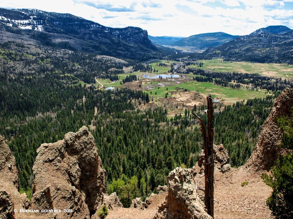
Near the east end of the SJNF is the Piedra Special Management Area, consisting of more than 62,000 acres set aside for purposes similar to wilderness areas, except that certain water rights issues in the Piedra River watershed prevented it being declared a wilderness under the 1993 Colorado Wilderness Act. But don’t worry, it has the feel of wilderness splattered all over it. Much of it is virgin forest, now protected against future logging and road-building activities. The river and its tributaries are teeming with rainbow and brown trout. The endangered river otter has been reintroduced here into its native habitat. The wonderful trail along the river may not be a mountain path, but it is a fine walk for anyone who enjoys the great outdoors.
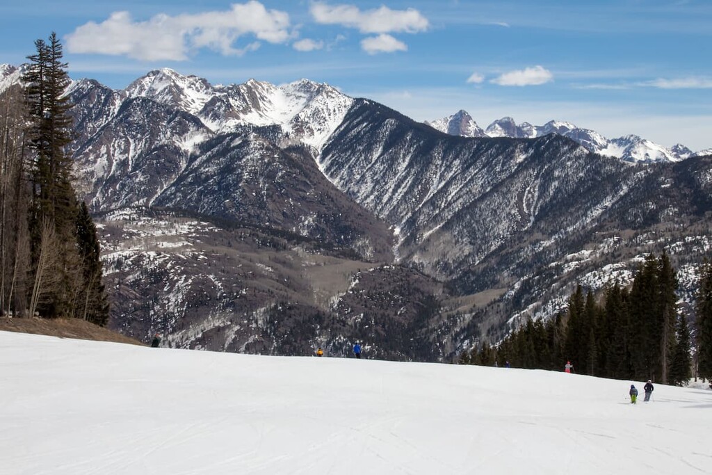
There are several ski resorts in or immediately adjacent to the San Juan National Forest. The Wolf Creek Ski Area is perched near the summit of Wolf Creek Pass on the Continental Divide, which serves as the eastern boundary of the forest. This ski area is especially handy to residents of and visitors to the town of Pagosa Springs. In the heart of the forest is the Purgatory Resort, just a short drive north of Durango. And Silverton has its own ski area, but this one is different from any others - it is not really a resort but an area for skiers and boarders to practice extreme winter recreation in pristine alpine terrain suitable only for experts.
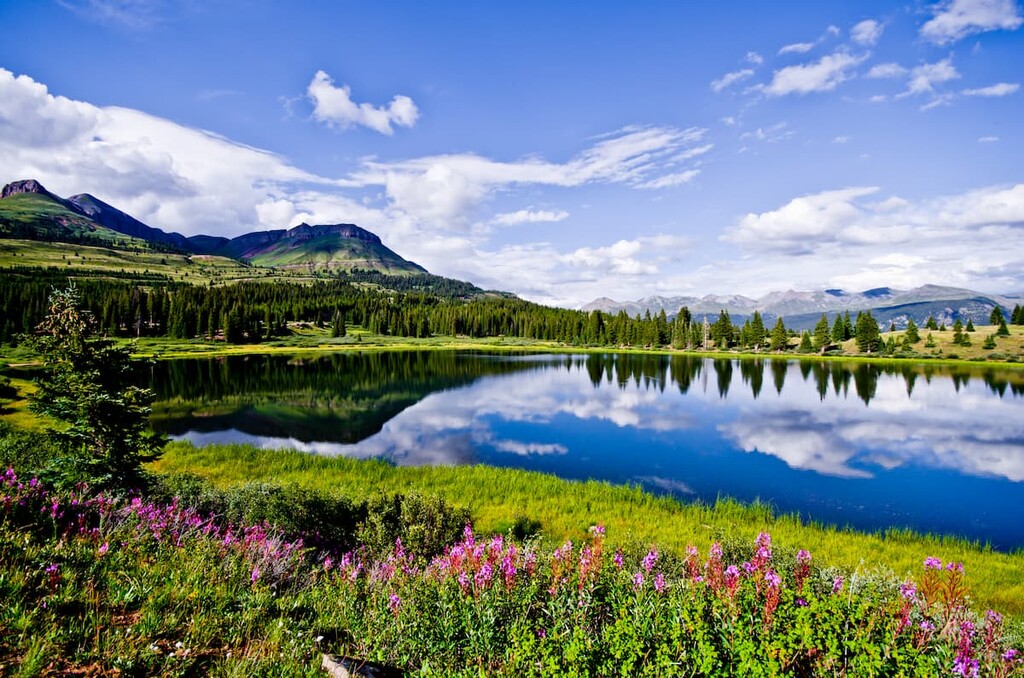
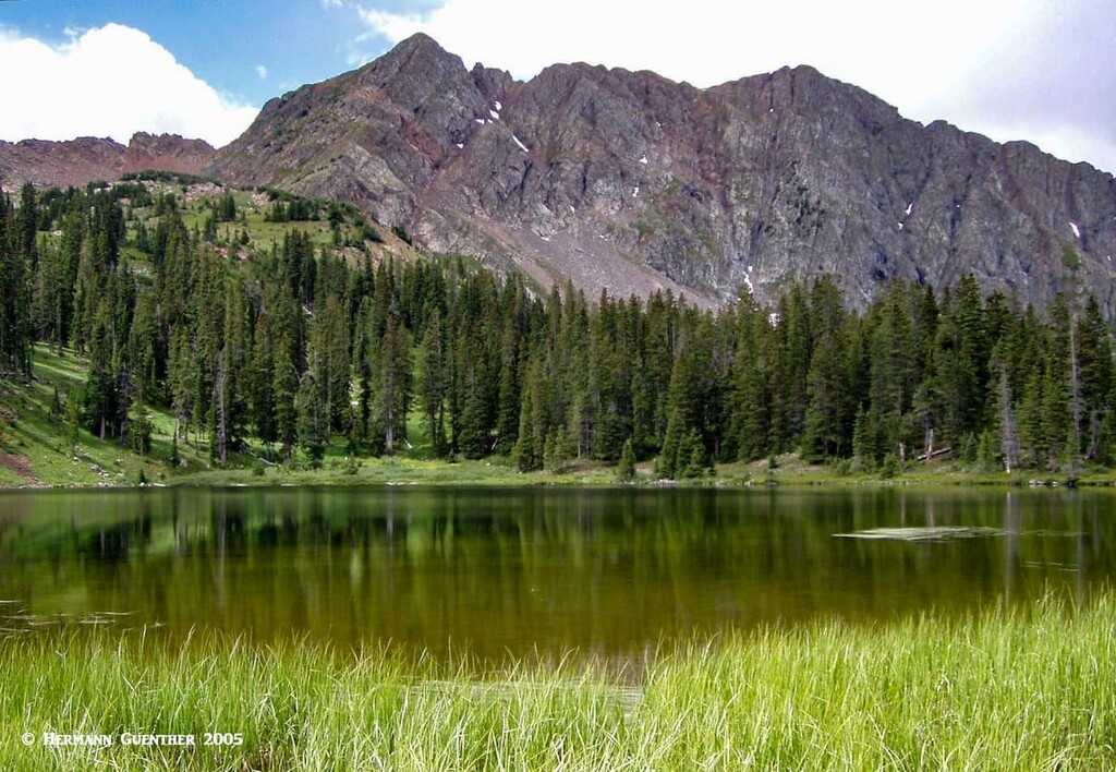
Finally, there are a few big lakes within the boundaries of the San Juan National Forest. The Vallecito Lake (Reservoir) is considered one of the most beautiful bodies of water in Colorado. Only 20 miles east of Durango, nestled at an elevation of 8,000 feet in a scenic valley deep in the San Juan Mountains, this lake affords all kinds of water sports, including boating, kayaking and fishing. Ice fishing is very popular here in the winter months, and there are several campgrounds by the lake as well as trailheads for hiking into the mountains. In the western part of the forest is the McPhee Reservoir near the town of Dolores in Montezuma County. It is named after the town of McPhee which was submerged after the dam across the Dolores River was completed in 1985. It provides various boat-launching sites, picnic areas and campgrounds in the McPhee Recreation Area operated by the U.S. Forest Service. This is the second largest lake in Colorado with a shoreline of 50 miles.
To list all of the major hiking areas in the San Juan National Forest would be a monumental task involving a hiking guide book of several hundred pages. So we are limited here to just touching on a few places, some that are highly popular and others less well known, but which I have experienced and can speak of with some personal knowledge. Let’s start at the eastern end of the forest and work our way west from there.
The nicely situated town of Pagosa Springs is an ideal spot to make a base for some fine exploration in the nearby mountains. There are many trailheads and campgrounds outside of this pleasant town, especially to the northwest. There are good roads to reach these areas, even gravel forest roads that can easily be driven in passenger cars.
Fourmile Trailhead – The hike starting at this trailhead (about 14 miles from the center of Pagosa Springs, following County Road 400, which becomes Forest Road 645 at the forest boundary) is really grand, even if you only go as far as Fourmile Falls, two of the great waterfalls in Colorado. It is about four miles to the falls, so it would be classified a moderate hike. But you should definitely continue along upper Fourmile Creek to Fourmile Lake, a real alpine gem. That will make for a 12-mile day hike. Most hikers will return via the same trail, but there is a longer alternative that turns this into a 14.5-mile hike. From the lake you can return to the same trailhead by taking the lightly used Anderson Trail. This hike takes you deep into the Weminuche Wilderness Area, the largest in Colorado.

Piedra River Trailhead – If you drive two miles west of the center of Pagosa Springs on U. S. Highway 160 you will get to the intersection with County Road 600. Follow this, in combination with CR-631 for 16 miles to this trailhead. There is an obvious parking area on the left side of the road. In just a short distance walk you will be at the side of the Piedra River which you can follow for miles downstream. Depending on how far you care to walk, this is an easy hike with lots of minor ups and downs – therefore this is very popular. The hike will take you over meadows, through a box canyon and generally meandering terrain. Most casual hikers will turn around at the foot bridge, about 3.5 miles in. When I did this, I continued another two miles or so to get further away from the trailhead, although the trail was by no means crowded at that time. I caught some very fine trout along the way.
While Silverton is not within San Juan National Forest, it is just one mile from the boundary near the northern end of the forest. This is where you can find the trailhead for one of the most spectacular hikes in the San Juan Mountains. I will describe one of these in some detail, but for other hiking ideas I suggest checking out this link: https://peakvisor.com/adm/san-juan-county-colorado.html.
Ice Lake Trailhead – Drive just over two miles north on US-550 from town and then go left on Forest Road 585 for another five miles to this very popular trailhead. All the hikes from here are considered strenuous by most sources. The trail that diverges into branches that can be hiked individually or in combination, depending on factors such as conditioning and weather, which can change rapidly and without warning. The three major lakes in this basin are all above 12,000 feet which means just to get to any one of them means elevation gains of from around 2,700 feet to around 2,900 feet – more if you want to combine two or more lakes in one hike. I believe that anyone who is well-conditioned and acclimated to the altitude can do any combination, although it will result in a tough day. These are not technical hikes or climbs.
The three main lakes that you will find here are Island Lake, Ice Lake and Fuller Lake. They are sometimes collectively called the Ice Lakes, which sit in two high-alpine basins surrounded by spectacular peaks, all between 13,700 and 13,900 feet in elevation. While these can all be climbed from these basins, that is not what most hikers here will do. It is the beauty of this place that attracts the multitudes. Typically, in late July and August, these basins are covered in wildflowers. Since everything in the basin is above timberline, there is little natural shelter to be found so that hikers are cautioned about rapidly developing summer thunderstorms. (A note of caution – as of October of 2020, these trails were closed due to an active wildfire. They are bound to be reopened once it is considered safe to do so.)
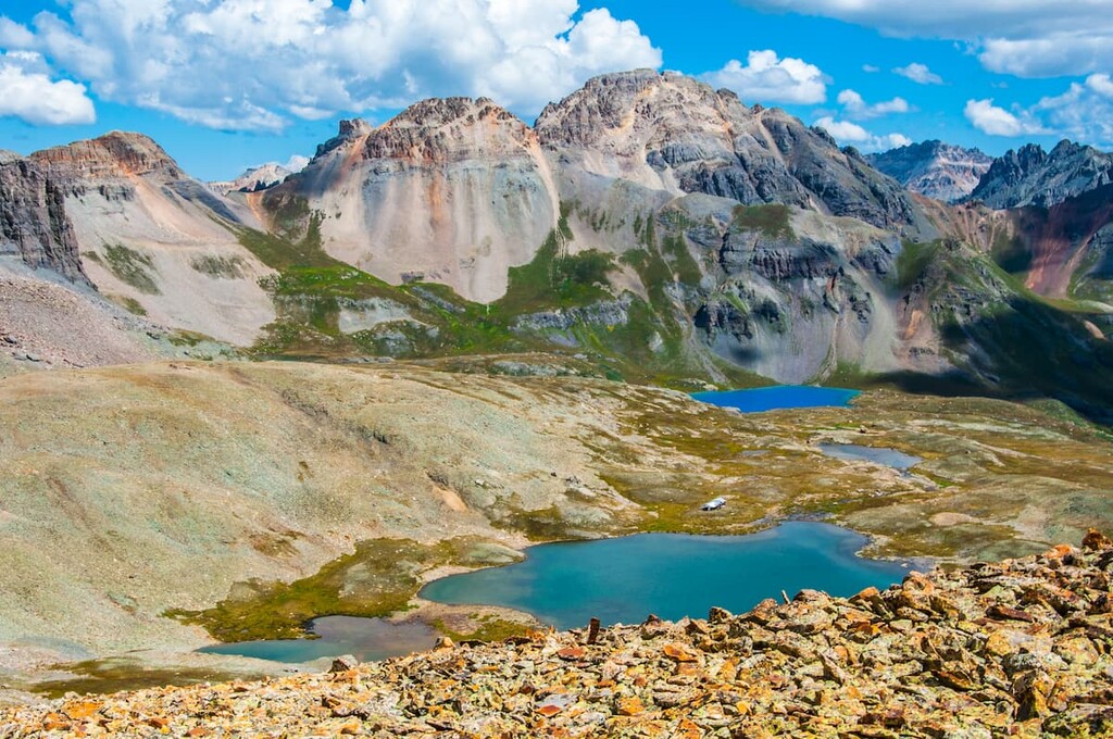
The one-way distance to either Island Lake or Ice Lake is only around 3.5 miles, which should tell you that the trail is steep, given the substantial elevation gain. If you plan to take in all three lakes, you will be looking at a round-trip hike of almost 10 miles with well over 3,000 feet of overall elevation gain. Strenuous to be sure, but not nearly approaching the magnitude of climbing most fourteeners. I have not made that hike yet, although I had started to do so only to have to cancel because of storms that were developing even early in the morning. This one is still on my bucket list.
The three hikes described below are in the western end of the fabulous Weminuche Wilderness Area. They are also under the jurisdiction of the Columbine Ranger District of the San Juan National Forest. Chicago Basin is in La Plata County while the others are in San Juan County.
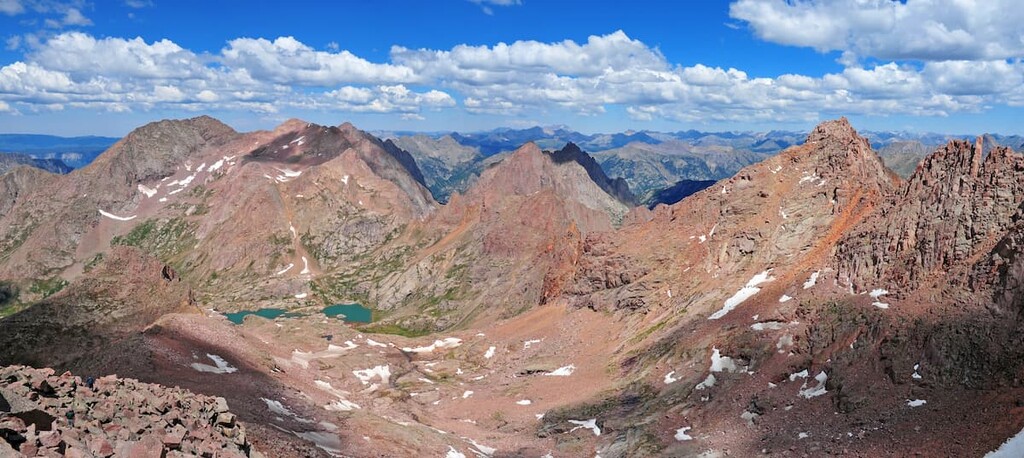
Chicago Basin - Chicago Basin is one of the most spectacular mountain settings in Colorado and probably in the entire country. In the summer, late July and August, the alpine meadows high up in the basin are full of blooming wildflowers which, together with the dramatic mountain backdrop, can provide a setting for some great photography. There are no camping spots along the trail until you reach Chicago Basin, and there is a permanent fire ban in the entire Needle Creek drainage basin. You get to Chicago Basin by taking the Durango and Silverton Narrow Gauge Railroad – at least that’s how most hikers and climbers get there. There are alternative approaches which allow you to drive your car to the trailhead, but you will be faced with a couple of additional days of hiking just to get there and back (see https://peakvisor.com/adm/la-plata-county.html for more information about this).
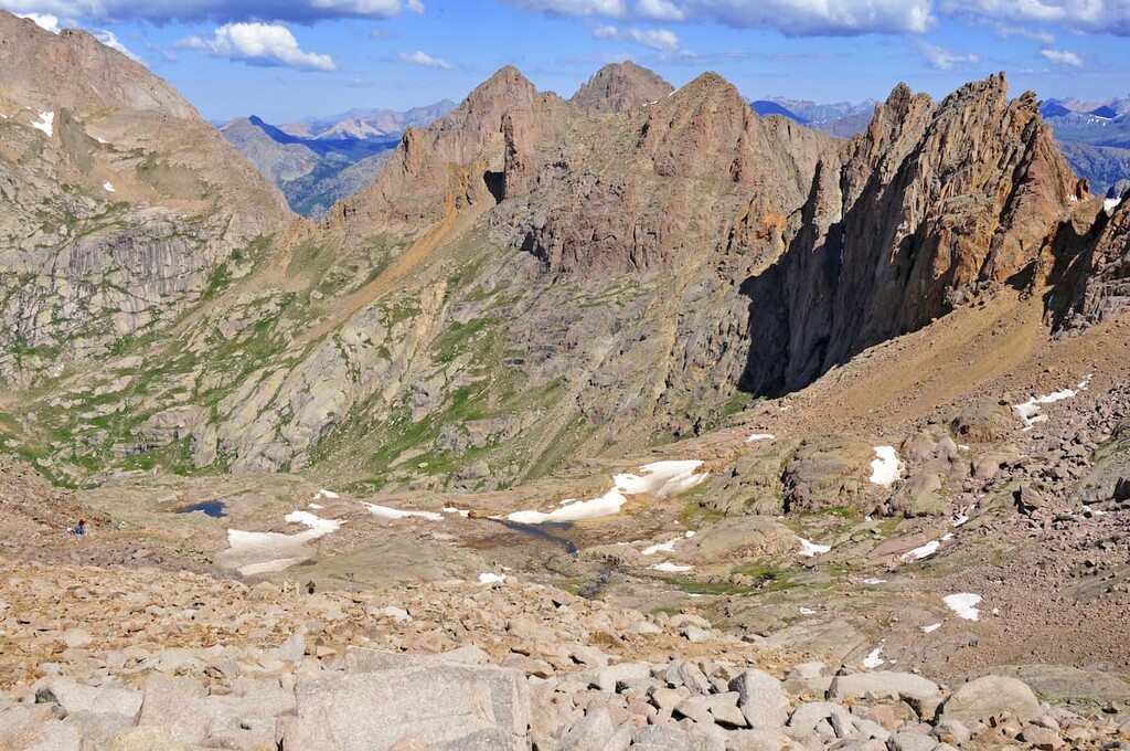
Once you are in the basin, there are several well-used routes to climb the famous fourteeners. Windom and Sunlight Peaks are at the east end of the upper basin and are separated by a jagged ridge of one-half mile. On the west end of the basin is Mount Eolus and its slightly lower brother, North Eolus. Sunlight and Windom are often climbed together due to their proximity to each other. If you just want to climb one summit in the basin, Windom is the easiest. On the other hand, Eolus on the west side is the most difficult, and it is often combined with North Eolus which, though not a ranked fourteener, is one of 58 named mountains in Colorado over 14,000 feet. Some hardy climbers will combine all three of the fourteeners in a single climbing session. The easiest way to do this is to climb Eolus first, then return back down to Twin Lakes, continuing up Sunlight, then traversing (below the connecting ridge) to Windom, from where you can descend back into the basin by its west ridge. A tough day to say the least!
Molas Lakes Trailheads – If you drive north on US-550 a little over 40 miles from Durango to the Molas Lake Park and Campground you will have a choice of two trailheads offering several fine hikes for various abilities and levels of conditioning. From here you can do an easy 6-mile round-trip hike to the Little Molas Lake, which lies to the west and about 800 feet higher than the main Molas Lake. You can start this hike at either end, but if you are like me, you might want to start at the lower lake so that you end your hike going downhill. But either way, this is an easy hike and great for families with children and for those who are not yet sufficiently conditioned for more ambitious hikes. Keep in mind that doing this hike will require that you cross the highway twice –but that should be no big deal. It is after all just a two-lane road. If you want to do a little bit of peak-bagging, you can start at the upper lake (Little Molas) and climb Sultan Mountain (13,327 feet) while taking in Spencer Peak (13,068 feet) on the way. This 7-mile round-trip hike is considered strenuous not because of the distance, but because of the 3,000-foot total elevation gain. Keep in mind that this whole area is quite exposed to the weather.
Andrews Lake Trailhead - Drive three miles or so south from Molas Lake and you will find Andrews Lake. Be sure to stop at the Molas Pass overlook about halfway there. You will be impressed by the views from this spot. When you get to Andrews Lake, which is a short distance off the highway, you will find two parking areas, the first one being for oversized vehicles while the one closer to the lake is for cars. Park here. If you just want a short stroll that just about anyone can do, take a walk around the lake – it’s only one mile and almost completely level. The views across the lake are splendid in just about every direction. But that is not what I came here for.
The hike from Andrews Lake to Crater Lake (here is another one by that name!) will take you into the Weminuche Wilderness and the West Needles Mountains. This beautiful hike of at least 11 miles round-trip will give you some fantastic views, especially of Engineer Mountain which you will see off to the west for much of the hike. While the elevation difference from the trailhead to the lake is less than 1,000 feet, the total gain out and back is just over 2,000 feet due to many ups and downs along the way.
When I did this hike, I extended it to include a loop around Crater Lake as well as a side excursion to the pass above the lake. From there, you can look down into the Animas River Valley and the great Weminuche Wilderness. This is also the spot from where climbers would normally begin their ascent of Twilight Peak (13,146 feet), the most prominent mountain in San Juan County. I did not attempt to climb it since I was alone and saw no other people on this hike. Good thing too, as I encountered a pretty significant thunderstorm on the way back to the trailhead. But if you want a relatively easy, but long, hike, you could do worse than this one. The views along the way are really worth the effort.
If you drive 11 miles west on US-160 from the south end of Durango, you will find County Road 124 branching off to the north. It follows the La Plata River up into the high peaks (the La Plata Mountains) where you will find several trailheads and a number of campgrounds. This road ends at the southern boundary of the Hermosa Creek Wilderness, which is entirely within La Plata County as well as in San Juan National Forest and has a few hiking trails that penetrate it. If you want a good workout, try the trail to Deadwood Mountain (12,290 feet) and Silver Mountain (12,470 feet). This lightly trafficked nine-mile out and back trail will certainly challenge you with its total elevation gain of 4,020 feet. The lower part of the hike follows a jeep trail which begins at the La Plata City campground. For the truly adventurous and well-conditioned climbers, the two ranked thirteeners on the west side, straddling the La Plata/Montezuma County line, are Mount Moss and Babcock Peak. No official trailheads for these appear to exist, but that surely does not deter dedicated peak baggers from climbing them.
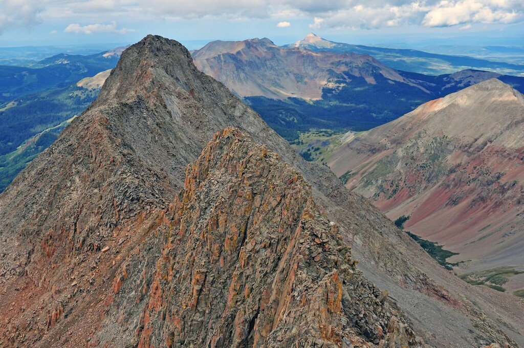
This small range of high peaks is located just west of Telluride. It sits in the Lizard Head Wilderness Area, which straddles the boundary between the San Juan National Forest and the Uncompahgre National Forest (therefore the county line separating San Miguel and Dolores Counties). The highest and most prominent mountain in the SJNF (Mount Wilson) sits within the wilderness and is a major climbing destination in the forest. It is a reclusive mountain, well-hidden by its neighboring mountains and cannot be seen from any highway.
Kilpacker and Navajo Lake Trailheads - These two trailheads, only two miles apart along the seasonal Dunton Road, just a short distance north of State Highway 145, can be alternatively be used to access the south and west slopes of Mount Wilson and its western partner El Diente (“The Tooth”) Peak. These two trails converge into one a few miles after the respective trailheads; the Navajo Lake Trail then continues into the Navajo Basin north of the El Diente-Wilson Ridge, from where the north slopes of these two peaks can be accessed. To the east of Mount Wilson, the ridge bears northeasterly over Gladstone Peak (13,894 feet) and onward to Wilson Peak, which is outside of the SJNF. This configuration of high peaks offers the serious and experienced climber plenty of opportunities to do some serious mountaineering.
Cross Mountain Trailhead - This trailhead right beside State Highway 145 pvides fine hiking access deep into the Lizard Head Wilderness. From here it is possible to make a 9-mile loop hike toward the impressive Lizard Head, one of Colorado’s most difficult summits in Colorado to climb. From Lizard Head, you can take the Lizard Head Trail down to its trailhead at the scenic overlook on SH0145. To get back to your car from here, you will have to walk along the road for a couple of miles, but at least you will have different scenery on the way back. Alternatively, you can do a one-way hike going past Lizard Head and on into the Uncompahgre National Forest; this becomes a 9-mile hike requiring a car shuttle. This is considered one of the classic hikes in this remote part of the SJNF.
As extensive as the San Juan National Forest is, it is generally much less visited in its westernmost reaches, which are not typically recognized as being mountainous terrain, since much of this area is characterized as plateau and high desert. There are a few named mountains west of SH-145 with the exception of the Lizard Head Wilderness and the Wilson Group of fourteeners. Most of these are in the Uncompahgre National Forest. Consequently, though there are trailheads scattered about, these are not of major importance to visitors who come to Colorado for hiking. There are very few towns in this area and they are small. So for any readers that are interested in finding hiking trails, it would be best to inquire locally, since even major hiking websites or printed hiking guides offer little information about this area. Some small towns that may be able to provide relevant information for visitors might include Dolores, Rico and Dunton.
Being so large and widespread, it goes without saying the visitor to the San Juan National Forest will find a good selection of towns, and even some resorts. Most of these will be on the two major highways crossing the forest – US-550 from north to south and US-160 form east to west. While such small towns as Bayfield, Mancos, Dolores or Rico will offer some tourist amenities as lodging and restaurants, it is the larger towns, including Pagosa Springs, Durango and even Cortez that will be better equipped to cater to greater numbers of visitors, with a great variety of hotels, restaurants and shopping venues.
This elegant town, sitting at the western end of Wolf Creek Pass, is the first that visitors from the east will encounter as they enter the San Juan National Forest. At first sight, one would immediately want to spend a few nights here. Since I first moved to Colorado in 1980, this town has grown in leaps and bounds. Though its population is only 2,085 (2019 estimate), it seems a lot larger due to its resort character. Where there used to be only one or two traffic signals, there are now at least seven or eight. Lately it seems that every time we drive through town, there is another one. But Pagosa Springs is pretty special, and its location in the middle of spectacular scenery doesn’t leave much to be desired. Major shopping centers and supermarkets can be found here along with some pretty high-end hotels. As the town’s name implies, there are bath houses and natural hot springs resorts and spas. For those who like to pull their own home behind powerful pickup trucks, there are plenty of RV resorts where to park them. And don’t forget, the Chimney Rock National Monument is only 20 miles west of town. It is an off-the-beaten-path archaeological site that preserves 200 ancient homes and ceremonial buildings of the ancient Puebloan Peoples.
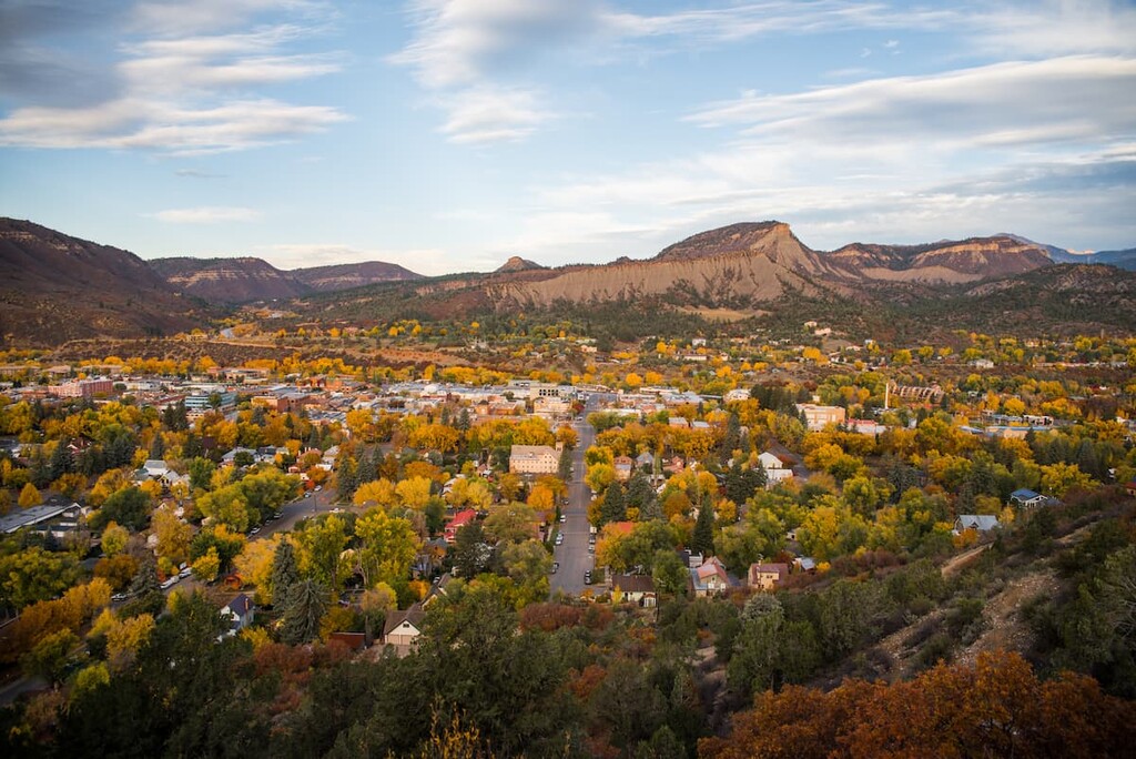
Durango shares its name with two other cities – one in Mexico and one in Spain. Many people find Durango just about the best place to live in Colorado. The town is small enough (just under 19,000 residents in 2019) to give the feeling of living in the mountains, yet large enough to offer its citizens and visitors just about all they can reasonably expect or require. There is no shortage of accommodations, restaurants and shopping venues. Even high-end hotels can be found here. Then you can also find major shopping centers, hospitals, schools and two colleges. The city can be easily reached by good highways and even has a regional airport that provides scheduled airline service to major hub airports such as Dallas, Phoenix and Denver. Durango offers many tourist attractions, not the least of which is the Durango and Silverton Narrow Gauge Railroad – so you can ride the rails to Silverton in the heart of the San Juan Mountains instead of driving your own car. And don’t forget, the Mesa Verde National Park, a UNESCO World Heritage Site, is just 35 miles to the west. It is worth exploring the historic downtown Durango on foot – you will find restaurants with western charm (and tastes) as well as boutiques offering genuine Native American products – not made in “you know where”.
Whether you come here to ski at the only major ski area in the San Juan National Forest, or just want to feel the resort atmosphere during the summer, Purgatory Resort is a great place to base yourself if you don’t have the need for city amenities. The Village Plaza at the mountain’s base area features a choice of lodging, retail shops, restaurants and bars. All kinds of family-friendly activities can be found here including the Inferno Mountain Coaster, the area’s only alpine slide. And if you want to go hiking, there are plenty of places just a short drive from the resort. If you are interested in the attractions in and near Durango, that vibrant town is only 25 miles to the south. If venturing deeper into the San Juan National Forest is what you are looking for, the historic mining town of Silverton in adjacent San Juan County is only 22 miles to the north along US-550, one of the most spectacular highways in Colorado. Just give yourself plenty of time, since you will find many excuses to stop along the way.
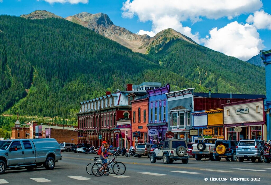
Appropriately named, due to its silver mining history, this little town is tucked right into the middle of the massive San Juan Mountains. Though it is not within the limits of the San Juan National Forest, it is close enough to function as a significant town from which to explore some of the most spectacular mountains in the forest. It can at times seem completely isolated, especially in the winter when the only access to the town is via U.S. Highway 550, which gets closed due to heavy snowfall and avalanche danger. This is the northern terminus of the Durango and Silverton Narrow Gauge Railway, which brings thousands of visitors, although not in the winter. When the train is operating, the town is not quite so remote and isolated, and all of these visitors require amenities. Therefore, the town does have a good selection of accommodations and restaurants for those wanting to stay and explore the area. Silverton offers a great number of outdoor activities, summer and winter, too numerous to list here. It is unlikely that anyone would get bored in this idyllic mountain hamlet with its stunning setting.
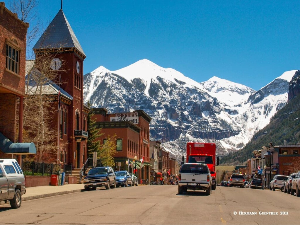
The wonderful town of Telluride is not in the San Juan National Forest. But it is nearby and is the only major town close to the San Miguel Mountains and the Lizard Head Wilderness. This makes it a fine base from which to do some serious climbing of peaks such as Mount Wilson and El Diente Peak. As a ski town, Telluride is somewhat unique as compared to the more famous glitzy resorts (not to be named here) elsewhere in Colorado. Though it has 5-star accommodations (after all, people fly there in their private jets), Telluride is unpretentious and prefers to maintain its "old west" style. It is simply an old western mining town that grew into one of America's most loved ski towns. Celebrities who prefer to avoid the limelight and attention come here, and even own property. But people love it for its amazing setting in the most rugged terrain in the San Juan Mountains. No wonder visitors come here as well for reasons other than skiing. With a permanent population of less than 2,500, the town is not likely to get much bigger - its geology prevents growth and urban sprawl more effectively than does legislation. When not catering to skiing, Telluride offers all kinds of recreational activities - jeeping, golf, fishing, mountain biking, and of course hiking and climbing. And of course this town is also known for its summer music festivals.