Scan the QR code and open PeakVisor on your phone
Southwest Colorado has a strong Spanish influence, which is why there are so many Hispanic place names. San Miguel County was given a Spanish language name for Saint Michael and was named after the San Miguel River which finds its origins in the mountains high above Telluride, the county seat. The river itself is the result of the convergence of Bridal Veil Creek and Ingram Creek. The county is one of 64 counties in Colorado and was founded on February 27, 1883 when it was carved out of the then much larger Ouray County. It has an area of 1,291 square miles, which makes it more than double the area of what is left of Ouray County today.
While San Miguel County has 96 named mountains, of which Wilson Peak is the highest and Lone Cone the most prominent, it is not generally considered a mountainous county. The really high mountains are at the east end of the county where it borders on adjacent high counties. Extending 70 miles to the west, where it borders on Utah’s San Juan County, much of the terrain lies in the high Colorado Plateau, where a number of prominent elevations occur and are consequently counted as mountains, although these are generally well below 10,000 feet in elevation.
The estimated 2019 population of San Miguel County is 8,179, which results in a population density of less than six people per square mile. Almost 50% of the total population resides in Telluride and the connected town of Mountain Village, which combined have a density of over 700 people per square mile. This means that the rest of the county has a density of only 3.3 people per square mile. There are only three other small towns in the county plus seven unincorporated communities for which there are no population statistics. There are only three state highways (SH-62, Sh-141 and SH-14) in the county, which again substantiates how rural this county really is. Consequently, most of it is not renowned for its recreational appeal. But those parts that are, deserve close attention – which they surely get.
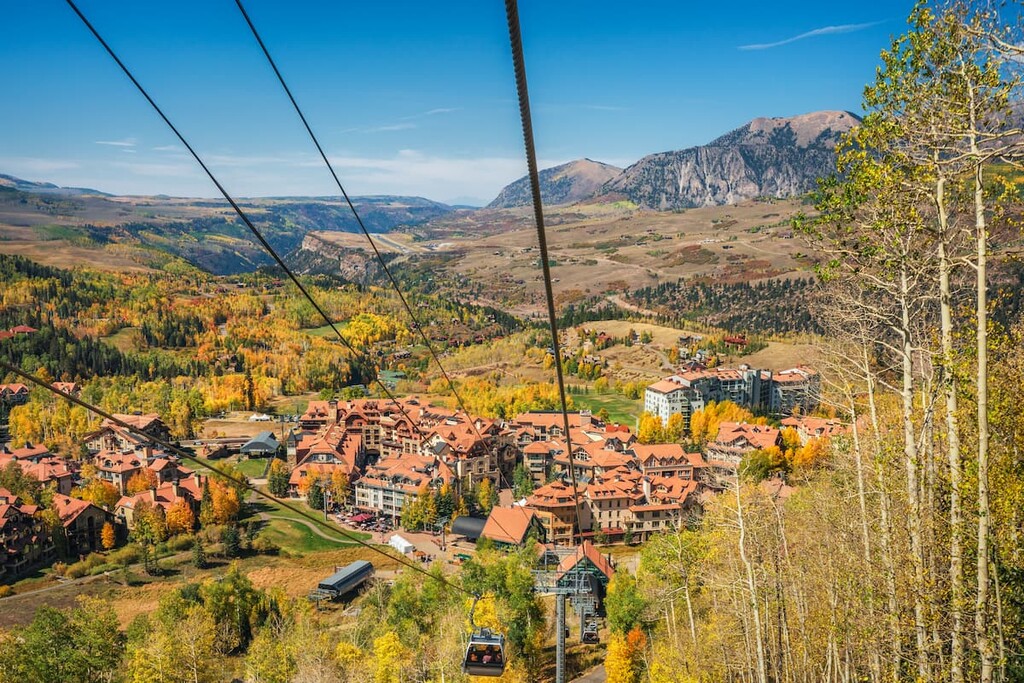
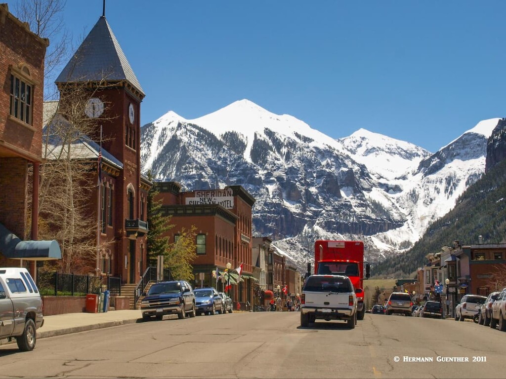
It goes without saying that the single most important and famous recreation center in San Miguel County is Telluride – not only the town but its renowned ski area. Yes, Telluride, tucked into a tight mountain valley, even has an airport with commercial airline service, which is less than six miles from the town center and sits atop a high mesa with precipitous drop-offs at both ends of, and beside, the single runway. It must be one of the most spectacular airport approaches in the world. At 9,078 feet, it is the highest airport in the United States with scheduled passenger service. The ski area itself only came into existence in 1972 when the first ski lift was installed. Good thing too, because the mainstay industry of mining had become phased out by this time, which had sustained the town for many years. But even as skiing grew in popularity, Telluride managed to maintain its old western charm.
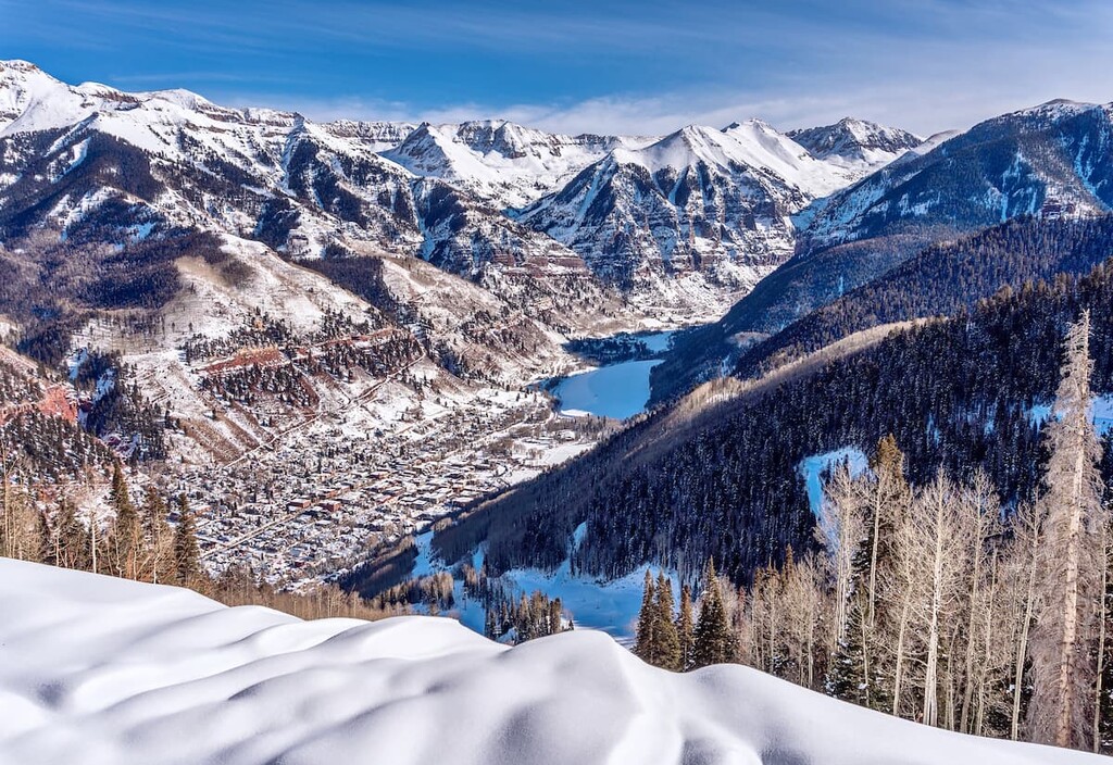
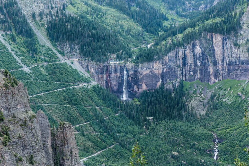
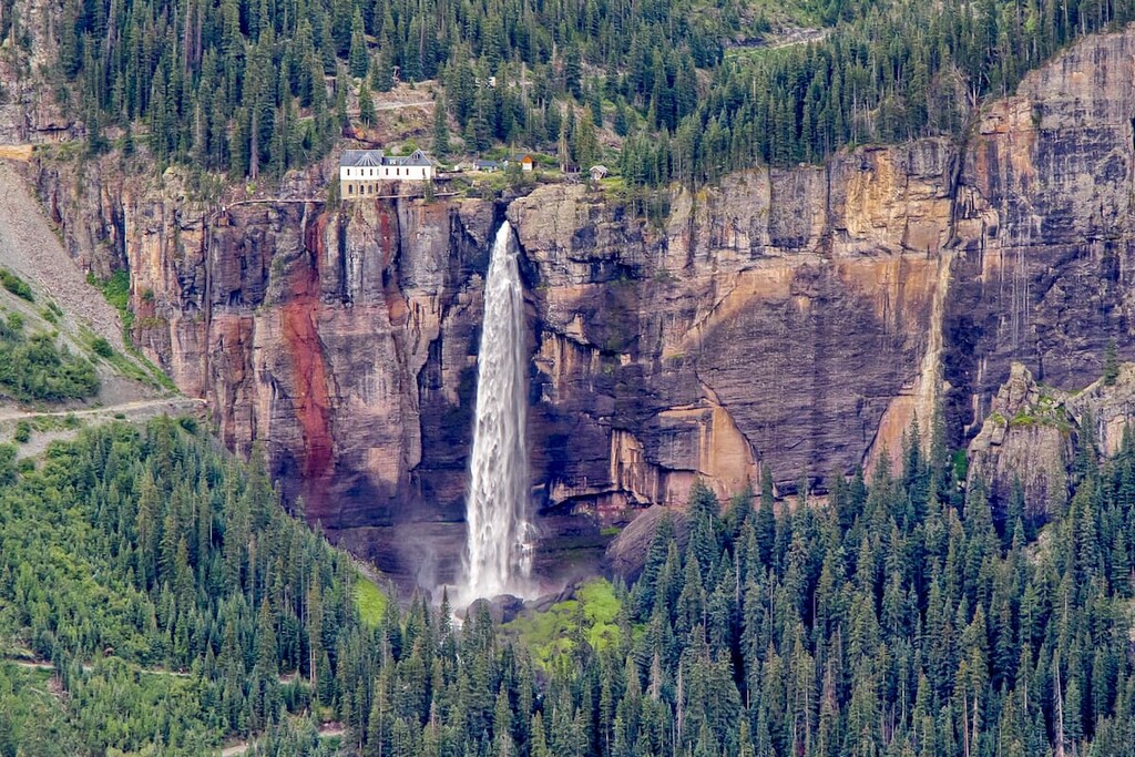
The high mountains around Telluride, especially those perched on the boundary with Ouray County to the northeast, are a magnet for photographers as well as hikers and climbers. Once the resort became known as “Colorado’s best-kept secret”, it ceased to be a secret and became one of the state’s best-known resorts – not just for skiing but also the many other activities to be experienced nearby in the county. Aside from skiing, hiking and climbing, four-wheeling is very popular in San Miguel County, most notably the notorious Black Bear Road. This one-way only jeep road starts at the top of Red Mountain Pass on U.S. Highway 550 in San Juan County and then crosses into San Miguel County at Black Bear Pass (elevation 12,840). The final plunge into Telluride over the infamous switchbacks is not for novices. Another equally popular and dangerous jeep trail is the one over Imogene Pass (at an elevation of 13,114 feet, the second-highest vehicular mountain crossing in Colorado) which connects Yankee Boy Basin near Ouray to Telluride. Also not for those lacking a sense of adventure. Just before Telluride, the Black Bear Road passes Bridal Veil Falls (I wonder how many waterfalls have that name!), the highest waterfall in Colorado.
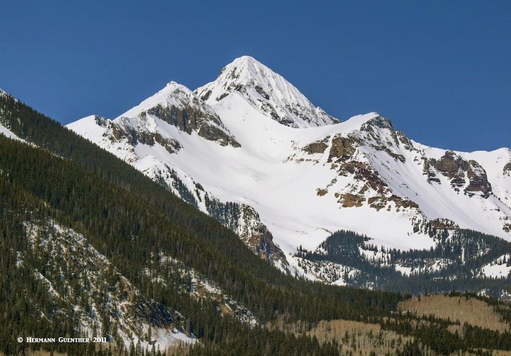
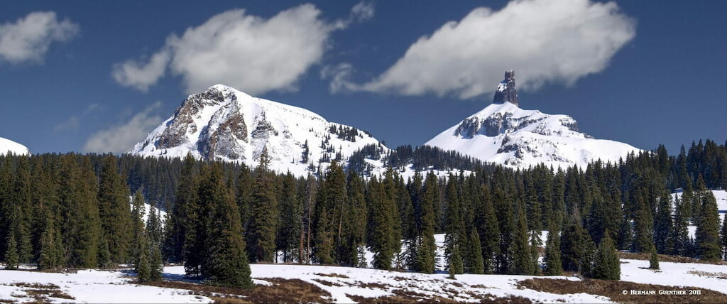
But many visitors don’t come to San Miguel County for skiing or jeeping. They come to climb the westernmost fourteeners in Colorado, one of which is the highest point in the county – Wilson Peak. In addition, of the 96 named mountains in the county, there are 32 mountains that exceed 13,000 feet in elevation most of which are “official” or “ranked” thirteeners, which means that they have at least 300 feet of prominence. All of them are in the eastern third of the county, and many of those are rarely climbed. But there are other interesting hikes and climbs in the county that are excellent, and sometimes difficult or even dangerous for novices. We will take a look at a few of them now.
Silver Pick Basin Trailhead – Wilson Peak is one of three peaks (the other two are Mount Wilson and El Diente Peak – more about those in a subsequent article) that make up the Wilson Group, which are the dominant features of the San Miguel Mountains. All three are often climbed together resulting in a tough hike to be sure. This trailhead is for those who would like to climb Wilson Peak by itself from the north side. The Rock of Ages Trail that starts here is the easiest approach to this marvelous mountain – nine miles and about 3,500 feet of elevation gain. It is considered a Class 3 ascent due to some significant exposure and some rock scrambling near the top. The trailhead can be reached via the Silver Pick Road which intersects SH-145 about six miles west of the main intersection in Telluride. The road is about eight miles long, and marginally passable for passenger cars. High-clearance vehicles would be a good idea. Wilson Peak sits at the edge of the Lizard Head Wilderness.
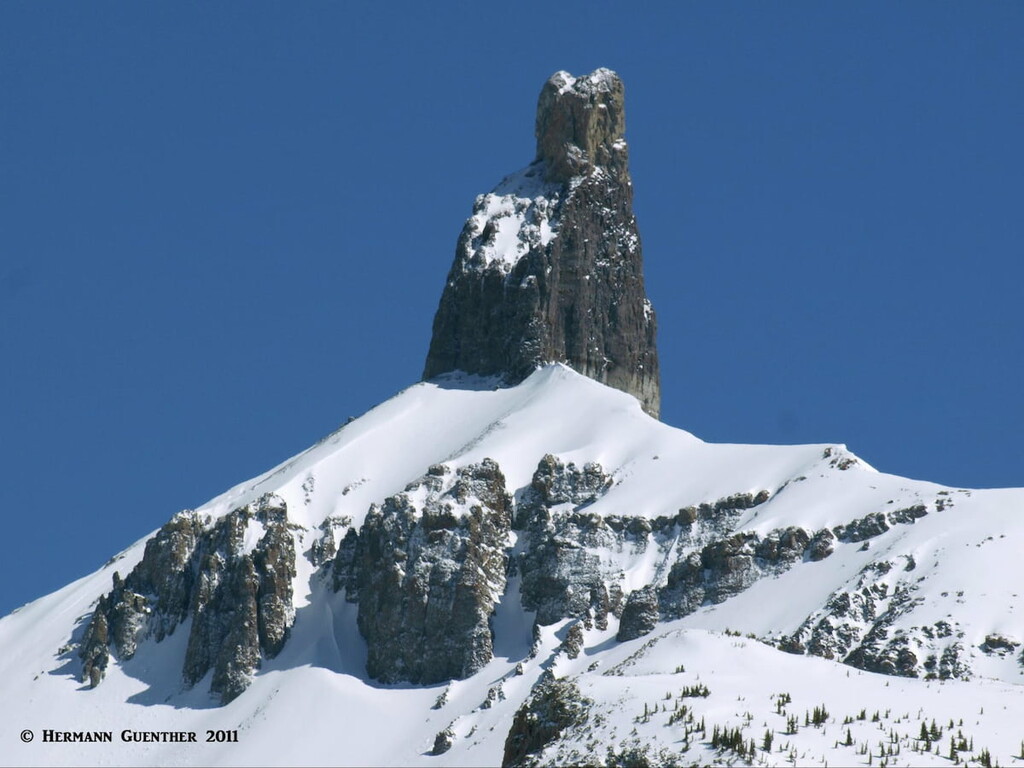
Lizard Head Trailhead – This trailhead is located at the summit of Lizard Head Pass, the high point of State Highway 145, which defines the boundary between San Miguel and Dolores Counties. From here it is possible to do a magnificent hike one-way in the Lizard Head Wilderness. For this, you will need to do a vehicle shuttle so that you can do this moderate 9-mile hike to the other end which is at the Wilson Mesa Trailhead (also known as the Sunshine Mesa Trailhead). This hike will take you to the foot of the incredible Lizard Head. But you don’t have to climb it – just enjoy the immensity of it. It is considered one of the most difficult summits to climb in Colorado. Just past Lizard Head, the trail crosses a 12,000-foot pass from where it gradually descends through Bilk Basin past a series of wonderful waterfalls. If you don’t have two cars, you can always go to the pass at Lizard Head and return to where you started. And another option is to leave Lizard Head by the Cross Mountain Trail which returns you to a different trailhead just two miles south of the Lizard Head Trailhead on SH-145. You can get back to your starting point from there by hiking along SH-145, making this a 9-mile loop.
Sunshine Mountain East Ridge – If you are looking for solitude, great views and a little bit of adventure, look for this hike just outside of the tiny settlement of Ames about 12 miles south of Telluride on SH-145. At Ames is a very historic generating station which claims to be the world’s first to produce and transmit alternating current. Park here and then look for the Galloping Goose trail sign. From there, you are on your own and good navigating skills will greatly benefit you until you reach the ridge from where the route should become obvious. Poor markings at the lower end are sure to cause confusion, but the reward will be the views. This hike is between six and seven miles and entails an elevation gain of almost 4,000 feet.
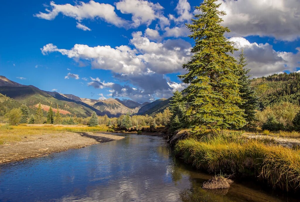
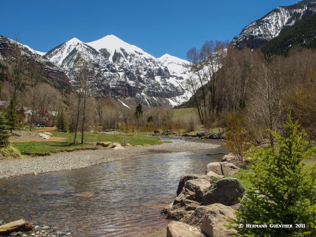
Telluride Trailheads – There are many hiking opportunities right from within the town of Telluride. Some, such as the San Miguel River Tail which starts from below town and goes three miles or more upstream to above the town. On the way it passes through Town Park which offers lots of other recreation activities. The upper part of the trail is definitely more scenic but all of it can be enjoyed by just about anyone, including families with children.
The Bridal Veil Falls Trail starts from near the end of the road in the community of Pandora east of town. This is rated as a moderate hike of five miles round-trip and about 1,400 feet of elevation gain. This one is good any time of the year, even winter when the falls are frozen – spikes or snowshoes are needed then. Views of the town are great from up here. Just to the west of town are several trailheads that provide access into the rugged backcountry on the south side of the Sneffels Range in the Mount Sneffels Wilderness. The Deep Creek Trailhead is one way for climbers to get to Mears Peak which is virtually unclimbable from the north side. The Mill Creek Trailhead is right at the edge of town and is one place from which climbers can begin their ascent of Dallas Peak. This is rugged and remote terrain and is not frequently used except for hardy climbers who want to conquer these difficult peaks.
Now we must keep in mind that in San Miguel County we are really at the “edge of civilization”. Well, not really, but we are far from any major towns other than Telluride. The nearest other towns of significance are Montrose to the north (65 miles away) or Cortez in the Four Corners region (75 miles away). Both will take a drive of about 1 ½ hours from Telluride. So if you plan to go hiking in this area and want to get an early morning start, you will most likely have to find your accommodations in Telluride, unless you are camping, in which case you have other options.
Telluride is situated at an elevation of 8,750 feet. You could do worse than stay in this delightful western town. First of all, this town has a spectacular mountain setting which is enough to get one’s hiking juices flowing. With a permanent population of less than 2,500, Telluride is not likely to get much bigger - its geology prevents growth and urban sprawl more effectively than does legislation. Though it has 5-star accommodations (after all, people fly there in their private jets), Telluride is unpretentious and prefers to maintain its "old west" style. It is simply an old western mining town that grew into one of America's most loved ski towns. Celebrities who prefer to avoid the limelight and attention come here, and even own property. That includes people like Tom Cruise, Oprah Winfrey and Ralph Lauren. Accommodations and eating venues are plentiful, though the former are bound to be pricey, especially during ski season and at times when the Telluride Jazz Festival or the Telluride Balloon Festival takes place in the summer. A free bus service called the Galloping Goose is provided that loops around the town and runs every 20 minutes.
Nearby Mountain Village is more of a residential development although a few lodges and rental condominiums can be found here. Mountain Village varies in elevation from about 9,000 feet to over 10,000 feet. The ski area has lift access from here as well as down in Telluride itself. It is connected with Telluride by a three-stage gondola – it is free and runs from 6:30 in the morning until midnight during both summer and winter seasons. The gondola cabins, which seat eight passengers each, feature bike racks as well as ski racks depending on the season. This gondola is the only one of its kind in North America. It takes you between the two towns in 13 minutes versus a 20-minute drive by road. During months when the gondola is closed (usually less than three months in shoulder seasons), free bus service is provided between the two towns.