
Scan the QR code and open PeakVisor on your phone
Kiowa Indian Tribe, Comanche Nation, Apache Tribe, and Fort Sill Apache Tribe has 136 named peaks. The highest is Mount Pinchot at 752 m. Other notable peaks include Mount Scott, Mount Sheridan and Baker Peak.
The Kiowa Indian Tribe (K’yakhome bah ah Hei-Dae), Comanche Nation (Nʉmʉnʉʉ), Apache Tribe, and Fort Sill Apache Tribe are a collection of sovereign Indigenous nations that once shared a reservation located in the southwestern region of the US state of Oklahoma. However, the reservation was disestablished in 2021. The region contains 136 named mountains, the highest and most prominent of which is Mount Pinchot at 2,467 ft (752 m).
Prior to 2021, the Comanche Nation (Nʉmʉnʉʉ) Kiowa Tribe, Apache Tribe, Caddo Nation, Delaware Tribe, Fort Sill Apache Tribe, and Wichita and Affiliated Tribes shared a jointly managed reservation that was located in the Southern Plains of Oklahoma. It was originally located in Tillman, Comanche, Caddo, Grady, Jefferson, Kiowa, Stephens, and Cotton counties.
The reservation was disestablished in 2021 following an Oklahoma Court of Criminal Appeals ruling. This appeals court ruling upheld a district court’s ruling earlier that year that found that a law passed by the federal government in 1900 had required the Tribal Nations to relinquish their claims to the land in exchange for financial compensation. The reservation had been created in 1867 for the Kiowa, Apache, and Comanche tribes.
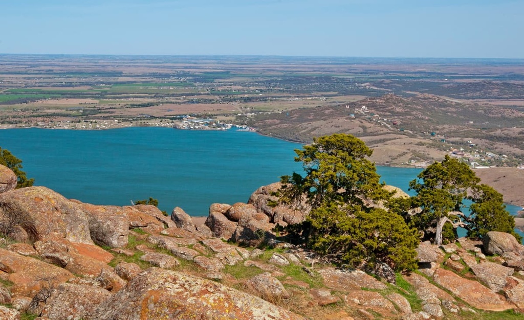
A sizable portion of the former reservation land lies within the Wichita Mountains National Wildlife Refuge, which encompasses part of the Wichita Mountains of southwestern Oklahoma.
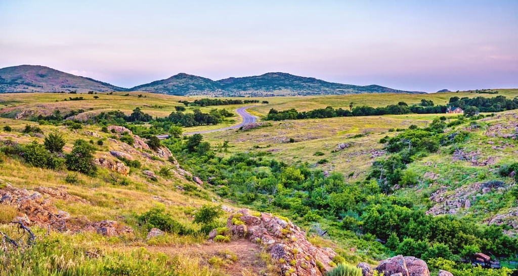
The land to the west of the wildlife refuge features flat and rolling plains and is often used as farmland. The peaks in the region trend in a northwest-southeast direction across the landscape. The peaks are incredibly rocky and craggy, and they often contain minimal vegetation.
Between the rugged peaks of the former reservation lie a plethora of unique geographic features. Rugged canyons and valleys in the region are met with alpine meadows and vast fields that are used for ranching. The gentle slopes that lie to the west of the mountains offer a sharp contrast to the range.
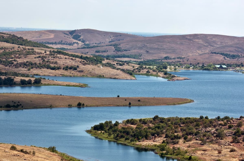
Major bodies of water in the region include Lake Lawtonka, Tom Steed Reservoir, Elmer Thomas Lake, and French Lake. Within the wildlife refuge section of the former reservation, there are also numerous smaller lakes. There are multiple creeks and streams that run throughout the region, particularly in the southeastern portion.
Additionally, the former reservation of the Kiowa Indian Tribe, Comanche Nation, Apache Tribe, and Fort Sill Apache Tribe is surrounded by popular outdoor recreation areas.
To the north of the Wichita Mountains National Wildlife Refuge also lies the Narrows Wilderness Area. Other nearby areas include Quartz Mountain State Park, Black Kettle National Grasslands, and the Lyndon B. Johnson National Grasslands to the south in the state of Texas.
The area of the former reservation of the Kiowa Indian Tribe, Comanche Nation, Apache Tribe, and Fort Sill Apache Tribe is part of two distinct geological regions: the Wichita Mountains and Southern Plains, the latter of which are part of the larger Great Plains.
Compared to other ranges in the US, the Wichita Mountains are quite old and they consist of rocks dating back nearly 600 million years. A majority of the range consists of granite, gabbro, and rhyolite, most of which formed around 525 million years ago.
During the Cambrian, many of the rocks in the region were formed, though they were subsequently affected by faulting and folding throughout the Paleozoic. The peaks were thrust upward during the Pennsylvanian Ouachita orogeny, which brought many of these rocks to the surface. Over the course of millions of years, the range was then heavily eroded to create the craggy peaks that we see in the region today.
Meanwhile, the Southern Plains of western Oklahoma primarily consist of limestones, shales, and sandstones. Around 540 million years ago, a shallow inland sea covered much of the Great Plains, leaving behind sediments that would later create the region’s rolling topography.
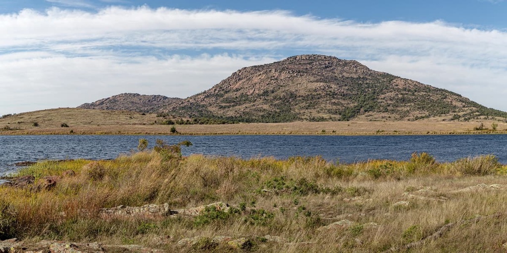
Major peaks located within the former reservation include Mount Pinchot, Mount Scott, King Mountain, Soldier’s Peak, and Tepee Mountain.
A majority of the flora and fauna in the former reservation of the Kiowa Indian Tribe, Comanche Nation, Apache Tribe, and Fort Sill Apache Tribe can be found within the Wichita Mountains.
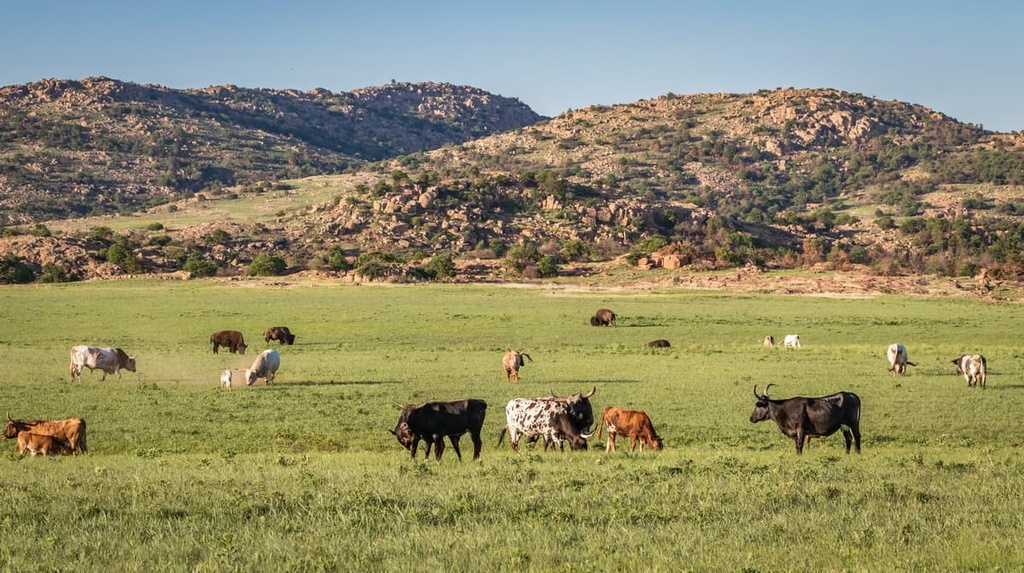
Large mammals that live in the refuge include plains bison, white-tailed deer, elk, and Texas longhorn cattle. Besides the white-tailed deer, these large mammals were re-introduced to the region with the formation of the refuge.
The original Merriam’s elk that once roamed the region are now extinct, so Rocky Mountain elk were introduced instead. Other mammals that live in the area include black-tailed prairie dogs, nine-banded armadillo, and bassarisk.
The reintroduction of bison helped save the species from extinction. In 1907, just 15 bison were brought to the refuge. The herd has since grown to include around 650 individuals. There are also numerous bird species in the Wichita Mountains, as the refuge is one of the only remaining places where you can find black-capped vireo.
The diverse landscape in the former reservation also features a wide range of flora. The rugged mountain peaks and ridges in the region contain little to no vegetation other than small patches of lichen.
The forested portions of the former reservation contain a mix of different oak species along with bigtooth maple trees. Many of the rolling foothills in the range feature low-growing grasses and wildflowers.
The lands of the former reservation of the Kiowa Indian Tribe, Comanche Nation, Apache Tribe, and Fort Sill Apache Tribe have been home to humans for thousands of years.
The Comanche Nation has historically been known as the “Lords of the Plains,” and the Comanche are related to the Shoshone people. During the end of the seventeenth century, the Comanche migrated away from the rest of the Shoshone to travel the plains in search of a new homeland.
They eventually traveled throughout what is now Wyoming, Colorado, Kansas, New Mexico, Nebraska, and Texas, before settling in the southwest of modern Oklahoma.
The horse was a vital element of the Comanche culture. Their horses helped them explore much of the Great Plains before they settled in the Wichita Mountains. Besides mastering horseback riding, the Comanche people would also breed horses as part of a wider trade network.
Unlike nearby tribes, the Comanche did not historically have a unified nation. Rather, the Comanche organized themselves into multiple smaller tribes that shared common languages and cultural beliefs.
While the Comanche were settling throughout the region, the Kiowa and Apache tribes were also in the process of traveling toward the Wichita Mountains.
When the Southern Kiowa left the Black Hills, they started forming an alliance with the Comanche. By 1790, the two tribes had formed an alliance, thereby establishing themselves as the dominant tribes of the southern plains.
Most of the tribal nations in the region had a difficult relationship with the American settlers who attempted to colonize the plains. Throughout the eighteenth and nineteenth centuries, the Comanche tribe was at war with various other tribes, in an effort to increase their own territory.
The arrival of settlers of European descent around this time, however, also heralded in the arrival of diseases such as smallpox and measles. By the mid-nineteenth century, these introduced diseases caused the death of thousands of tribal members in the region.
Not long afterward, as settlers sought out more land and the US continued its policy of westward expansion, the Comanche and Kiowa were increasingly pushed off of their lands. In the 1860s, the US began trying to forcibly remove the Tribes onto reservations via the Treaty of Medicine Lodge.
The Comanche tribe fought back against this forced relocation in what would come to be known as the Second Battle of the Adobe Walls. The Red River War in 1874 forced the remaining Comanche, Apaches, Kiowas, Arapahos, and Cheyenne people onto a reservation that was less than 5,000 sq. miles (13,000 sq. km) in area.
In the following decade, settlers hunted the region’s buffalo to the verge of extinction. This ultimately forced the Tribes to end their hunting practices and traditional ways of life. The remaining Comanche surrendered in 1875 and were forced to move to the Fort Sill reservation in Oklahoma.
The US Government formally established a reservation for the Apache, Comanche, and Kiowa in 1867 in what was then the southern part of the so-called Indian Territory in contemporary Oklahoma. This reservation was bordered by the lands of the Chickasaw Nation to the east and the Cheyenne and Arapaho nations to the north.
However, in 2021, the Oklahoma Court of Criminal Appeals upheld a prior ruling by a district judge that found that the Kiowa Comanche Apache Reservation no longer existed. This ruling was made on the basis of a law passed in 1900 by Congress that promised to provide financial compensation to the Tribes in exchange for relinquishing their claim to the land. As a result of this ruling, the Kiowa Comanche Apache Reservation was disestablished.
A majority of the hikes in the region of the former reservation can be found in the Wichita Mountains National Wildlife Refuge. Hikers should note that only a portion of the refuge is open to the public while other sections can only be accessed on a guided tour.
Here’s a quick look at some of the most popular hiking trails in this part of southwestern Oklahoma.
The Bison Trail is a loop route located in the southern portion of the wildlife refuge. The route follows the shores of French Lake and Lost Lake.
The landscape varies throughout the trail though it is dominated by flowing creeks, rocky canyons, and grasslands. This loop is 6.1 miles (9.8 km) long and it has 416 ft (127 m) of elevation gain. Both bison and longhorn cattle are frequently spotted along the route.
The Narrows Trail is an out-and-back route that winds through a rocky canyon. The trail follows West Cache Creek beyond its confluence with Panther Creek. Some sections of the route require walking over loose rocky terrain and there are a few creek crossings, too.
During the spring months, the land surrounding the trail features lush trees and blossoming grasslands. The towering rocky cliffs that stand high above the trail are also met with the slow-flowing water of West Cache Creek. This route is 2.7 miles (4.3 km) in length with 262 ft (80 m) of elevation gain.
The Wichita Mountains Forty-Foot Hole Trail is a shorter hike that takes you to a viewpoint overlooking the rocky canyon surrounding the West Cache Creek.
The walls of the canyon feature rugged rock formations and steep cliff sides while the creek cascades down in a series of small waterfalls. The route is 1.4 miles (2.3 km) long round trip and it has 154 ft (47 m) of elevation gain.
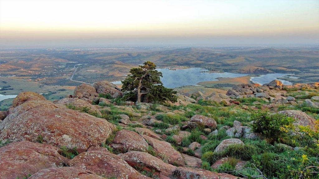
Mount Scott is the second-tallest peak in the region, and it is just a few feet shorter than Mount Pinchot. The route to the summit of Mount Scott is a paved road that hikers, bikers, and cars can all use.
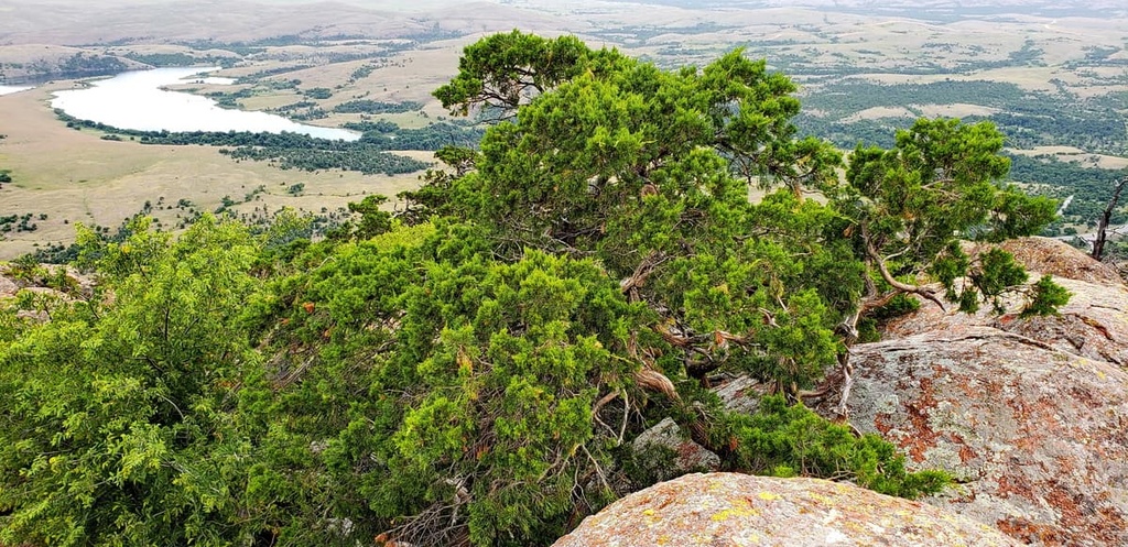
Once at the summit, hikers can enjoy panoramic views of the refuge and surrounding landscape. Rocky peaks, forested hillsides, and sprawling plains are all visible from the top of Mount Scott. The route is 5.6 miles (9 km) long round trip with 1,026 ft (313 m) of elevation gain.
Looking for a place to stay near the Kiowa Indian Tribe, Comanche Nation, Apache Tribe, and Fort Sill Apache Tribe? Here are some of the best cities and villages to check out in the region:
Home to the headquarters for the Comanche Nation, Lawton, Oklahoma lies along the southern edge of the Wichita Mountains National Wildlife Refuge. As it is home to around 95,000 residents, Lawton is the fifth-largest city in the state of Oklahoma.
Besides being located in the scenic foothills of the Wichita Mountains, the city is also home to the Museum of the Great Plains and Comanche National Museum and Cultural Center. Just outside the city lie Lake Lawtonka, Lake Ellsworth, and Elmer Thomas Lake, all of which provide opportunities for fishing, swimming, and camping.
Located just under an hour’s drive to the south of Lawton lies the city of Wichita Falls, Texas. The city is home to around 104,000 residents. The downtown streets of Wichita Falls are lined with local businesses, restaurants, and craft breweries as well as a plethora of coffee shops. Art murals in the city cover many of the buildings in downtown Wichita Falls, too.
In addition to its close proximity to the many hiking areas in the nearby Wichita Mountains, the city is also popular amongst cyclists. Mountain biking trails, such as the Wee-chi-tah Trail that follows the Wichita River, surround the city. Each year the city also hosts the Hotter’N Hell Hundred, which is the largest single-day century bike ride in the country.
Oklahoma City, Oklahoma is located just over an hour's drive northeast of Lawton. As it is home to over 680,000 residents, Oklahoma City is both the largest city and the capital city of the state. Despite its size, Oklahoma City is known for being a big city with a small town feel.
Popular sites to visit in Oklahoma City include the Oklahoma City National Memorial and Museum, Scissortail Park, National Cowboy and Western Heritage Museum, and Oklahoma City Museum of Art. Another great attraction in Oklahoma City is the Stockyards City, which allows visitors to take a step back in time and experience a town that’s modeled to look like the old “Wild West.”
For the outdoor enthusiasts among us, the Oklahoma River runs through the city and it offers ample opportunities for white-water rafting and kayaking. There are also plenty of great hiking areas situated just outside the city for visitors to enjoy.


The highest peak in Kiowa Indian Tribe, Comanche Nation, Apache Tribe, and Fort Sill Apache Tribe is Mount Pinchot, at 752 m.
Notable peaks in Kiowa Indian Tribe, Comanche Nation, Apache Tribe, and Fort Sill Apache Tribe include Mount Pinchot, Mount Scott, Mount Sheridan, Baker Peak and Mount Marcy.


