
Scan the QR code and open PeakVisor on your phone
Keelung City is home to 105 named mountains. The highest is Wufenshanxifeng at 740 m.
The historic port city of Keelung (基隆市) in northern Taiwan is wedged between New Taipei City’s (新北市) verdant hills. Wufen Shan Xifeng (五分山西峰) is the tallest of the 105 named peaks in the city’s boundaries at an elevation of 740 meters (2,428 ft). Mount Kamiko (姜子寮山) is the city’s most prominent mountain with a prominence of 208 m (682 ft).
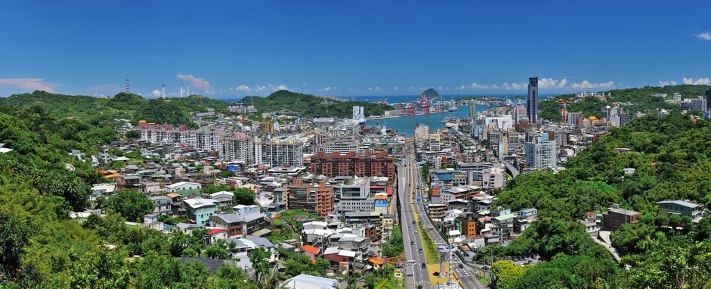
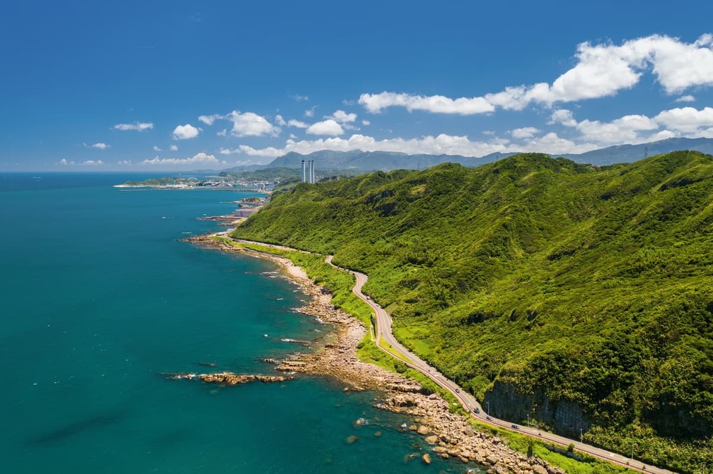
Keelung City is located on the northern coast of Taiwan near New Taipei City. Some of Keelung’s most prominent mountains, such as Xinshan (新山), Qiweilun (旗尾崙), and Shimenshan (石門山), form a high barrier around the city. The expansive Pacific Ocean lies to Keelung’s east.
With a territory covering 132,758 ha (328,052 acres) and a population of around 370,000 residents, Keelung is the largest port city in northern Taiwan. It is also Taiwan’s second-largest port after Kaohsiung (高雄市).
Thanks to the heavy rains it receives from the tumultuous northeast monsoon, Keelung is commonly labeled as the ‘Rainy City’ of Taiwan. Its annual average precipitation is normally at least 3,700 mm (146 in).

Although Keelung benefits from a humid subtropical climate, it is one of Taiwan’s coldest and wettest cities due to the impacts of the Kuroshio Current. Keelung enjoys a yearly mean temperature of 22°C (72°F). Summer temperatures in the city hit a high of 33°C (91°F) while winter temperatures drop to around 16°C (61°F), which is unusually cold for Taiwan.
There are seven districts in Keelung, and the city seat is in the Zhongzheng District (中正區). The city is also home to four islets, namely, Keelung (基隆嶼), Pengjia (彭佳嶼), Mianhua (棉花嶼), and Huaping (花瓶嶼) islets.
The peaks of Keelung City are technically part of the northeastern branch of the Xueshan Range (雪山山脈), the second-largest range on the island after the Central Mountain Range (中央山脈).
Stemming from Taichung City (臺中市) in the central part of Taiwan, the Xueshan Range extends northward through Hsinchu County (新竹) and New Taipei City into Yilan County (宜蘭縣) and Keelung City. The range itself is home to Taiwan’s second-highest mountain Xueshan (雪山).
The geological composition of the northeastern Xueshan Range primarily consists of slate and sandstone from the Miocene epoch. There are also some coal-bearing seams in the range.
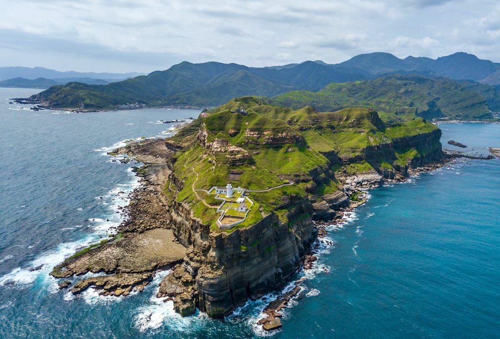
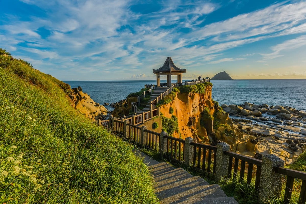
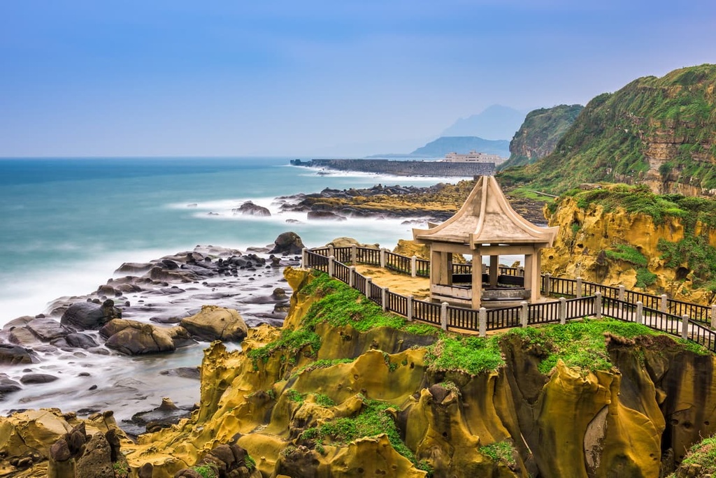
Northern Taiwan’s coastline is notoriously weathered and eroded as it serves as the first point of contact with summer’s vicious typhoons and the torrential northeast monsoons. For this reason, Keelung’s Heping Island is laden with mushroom rocks, which have been weathered and eroded into odd shapes by the wind and sea.
As Keelung is a hilly area, the city’s ecosystems vary quite a bit based on aspect and elevation. Hills exposed to the onslaught of Taiwan’s storms bear a slew of silver grass (Miscanthus sinensis), a hardy plant that thrives in extreme weather conditions.
In more sheltered regions that are protected by other hills or west-facing peaks, you’ll find dense broadleaf forests of eucalyptus, acacia, and Taiwan red nanmu trees.
Due to Keelung’s cold winters, coniferous trees grow in the lower elevation areas of the city as they thrive in chilly, damp environments. Therefore, you can find cedar and cypress trees in the mountains surrounding Keelung.
Keelung’s first inhabitants were the Indigenous Ketagalan tribe, who traditionally resided in northern Taiwan’s low-lying areas. With the increase in immigration and maritime expeditions in the seventeenth century, Keelung’s port city became a hotspot for foreign visitors.
Spanish sailors built Santísima Trinidad in 1624, a fortress protecting the Spanish from fellow invaders of Keelung. This fort was part of the Spanish Formosa colony, which occupied a small area of the northern tip of Taiwan between 1626 and 1642.
In 1642, the Dutch gained power in north Taiwan and took control of the Spanish fort. This victory lasted for twenty years, after which the Dutch fled to Japan after Koxinga’s troops successfully battled against the Dutch in southern Taiwan.
Due to a rise in trade and commerce in the Keelung region, the British started to take interest in the city and its port. However, British captain Joseph Pearse eventually learned that survivors of British shipwrecks in the waters surrounding the island were sent to southern Taiwan and executed. As a result, Captain Pearse bombed and destroyed the Keelung dockyard as retaliation, effectively severing ties with Taiwan in the process.
During the Japanese Occupation Era, Keelung’s port received a significant boost, making it more prosperous than the harbors of Tamsui (淡水) and Kaohsiung at the time. However, Keelung’s thriving port became a target during World War II, and in 1941, a bombing nearly wiped out the entire pier.
After the Japanese relinquished control of Taiwan in 1945, the local government rebuilt Keelung’s harbor to increase trade in the region and solidify its authority as a booming port for commerce. By 1984, Keelung’s harbor was ranked as the seventh-greatest container port in the world for trade.
Keelung City may be a metropolis that’s home to hundreds of thousands of people, but it is still a great destination for hiking and outdoor adventure. Here are some of the best hikes in Keelung City to check out during your next trip to the region.
The trek to Keelung’s highest mountain takes you along an undulating, wavy path that traverses both Wufen Shan (五分山) and Wufen Shan Xifeng. This trail is one of Keelung’s most scenic hiking paths as the views from Wufen Shan Xifeng overlook Keelung, New Taipei City, and the Taipei (臺北市) basin.
Wufen Shan is saddled between New Taipei City’s Ruifang District (瑞芳區) and Keelung City. At the southern foot of the mountain, on the New Taipei City side, lies an old coal mine where the current Xinpingxi Coal Mine Museum operates. This museum serves as the starting point of the 3.4 km (2.1 mi) trail to Wufen Shan.
The plant life of the two peaks varies due to the different aspects of each mountain. Wufen Shan’s north-facing peak only grows the resilient silver grass while Wufen Shan Xifeng lies behind its neighbor, sheltered from the brutal weather. Therefore, a vibrant forest of broadleaf and coniferous trees can be found on Wufen Shan Xifeng.
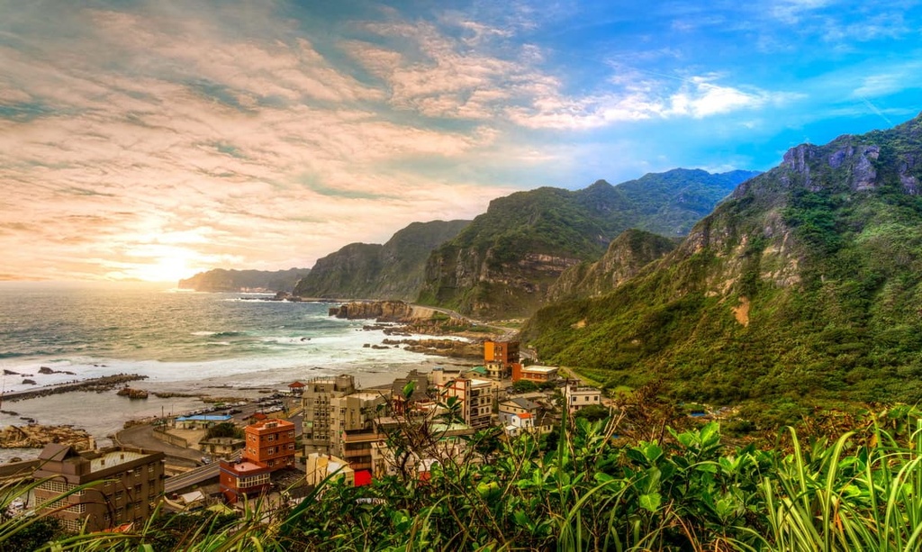
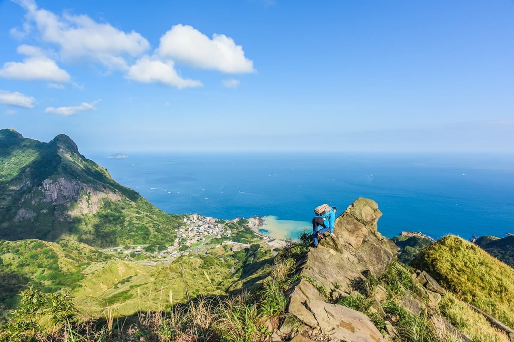
The highlight of this trail is the lookout from Wufen Shan Xifeng. Here, you can locate Keelung Islet in the distant waters. From the summit, you can also admire Taiwan’s northeast coastline, which features the rugged shores of Yehliu Cape Nature Reserve (野柳岬自然保護區).
The Mount Kamiko Hiking Trail is one of the most scenic trails in the Keelung City region, and it gives you a chance to summit the city’s most prominent peak. Mount Kamiko is located on the western border of Keelung City’ near New Taipei City’s Xizhi’s District (汐止區).
This trail up Mount Kamiko is just 1.6 km (1 mi) long, making it a popular choice for people looking to see the cherry blossoms during the spring months. The trail’s plant life is in full bloom during the spring and summer months, as the peonies, rhododendrons, begonia, lilies, and moon peach flowers all blossom around this time.
Once on Mount Kamiko’s summit, you can enjoy the unobscured 360-degree field of view. On a sunny, clear day, you can gaze afield onto the goliath Nanhudashan (南湖大山) in Taroko National Park (太魯閣國家公園) and even distinguish the snow-capped Xueshan in Shei-Pa National Park (雪霸國家公園).
Furthermore, from the summit, you can see the prominent Taipei 101 in the Taipei Basin as well as the other hills of Keelung City.
For a chance to wander in a forested landscape amidst a chorus of birdsong and chirping insects, visit the Tai’an Waterfall (泰安瀑布) and Butterfly Valley Trail. Wedged in the hills of Keelung, the Caolai River feeds the 20-meter (66 ft) high Tai’an Waterfall.

This 1.4 km (0.8 mi) long trail features an abundance of flowers, like wild ginger flowers, chrysanthemums, and New Guinea impatiens. There’s also an incredible cedar grove along this hike that fills the air with phytoncide, the forest bathing chemical that’s said to lower your stress hormones and clear your mind.
Tai’an Waterfall is located in the Butterfly Valley, which is aptly named due to its high concentration of butterflies. The purple-spotted butterfly, Taiwan crow butterfly, and Taiwan ripple snake butterfly are some of the common insects that you can encounter on this hike. You may also get to see the dazzling dragonfly, Taiwan blue magpie, and the multicolored Taiwan barbet on the Tai’an Waterfall and Butterfly Valley Trail.
Keelung's only alpine lake, Lover's Lake (情人湖), is located on the slopes of Dawulan Shan (大武崙山). A luscious forest of fragrant sandalwood and Japanese bay trees dominate the terrain around Lover's Lake's sparkling emerald waters.
On this 1.4 km (0.8 mi) long trail, you get to enjoy a casual stroll around this idyllic pond. As you make your way along this hike, you’ll even get to climb to the top of Eagle Rock (老鷹岩), which offers views of Keelung's sandy bay.
Eventually, your journey will take you to Dawulan Shan, where you’ll encounter the historic Dawulan Fort. While much is unknown regarding the stronghold's establishment, it was rebuilt and remodeled on two different occasions: once during the Qing dynasty's reign in 1871 and in 1945 at the end of the Japanese occupation era.
Dawulan Fort offers sweeping views of New Taipei City's Jinshan (金山區) and Wanli (萬里區) districts. It also provides good vistas of Keelung's coastal peaks and its busy port.
The trail to Dawulan Shan is coated with a thriving forest of eucalyptus, acacia, and cedar, while nature's soundtrack of melodious bird songs resonates in the surrounding woodlands Once on top of Dawulan Shan, you can wander at the marvelous scenes of Yehliu's rocky coastline, Lover's Lake's turquoise waters, and Keelung's prominent harbor.
The short 1.1 km (0.6 mi) trail takes you to Heping Island’s rocky shoreline and to the old Sheliao East Fort. This makes the Heping Island Mountain Trail the perfect destination for nature lovers and history buffs alike.
Since 1626, Sheliao East Fort has stood on Keelung’s coastline. At the time, the fort protected local troops and residents during the Sino-French War. If you head up to the top of the fortress, you can gaze as far as Yehliu in the north and you can even see Heping Island and Keelung Islet in the distance.
As you walk along Heping Island’s craggy coastline, you will get to see a collection of weathered rocks and terrain that’s been shaped by millennia of erosion by the wind and the sea. Clusters of mushroom rocks dot the shores of this trail, with sea cliffs and gouged sea caves lining the beach.
Keelung is a compact city, so you can easily access transport to Keelung's star attractions in and around its seven districts. The coastal and central districts of Zhongzheng and Zhongshan (中山區) are some of the best places to stay when visiting Keelung.
Keelung’s central-most district, Zhongzheng, boasts all the hustle and bustle of this scenic city. In fact, for such a small area, there are plenty of great attractions to enjoy within the Zhongzheng District.
The highlight of any adventure in Keelung is a trip to the coastal hillside of Zhongzheng Park. Here, you can check out the magnificent hillside Zhuputan Temple, which offers some of the best views of Keelung. In this park, you can also find the largest statue of Guanyin in southeast Asia.

Keelung’s prime key feature is undoubtedly its busy port, which is located in the Zhongzheng District. Zhengbin Fishing Harbor boasts a striking row of colorful old fishing houses. For an exciting experience, be sure to board the Folk Art, a ship docked in the harbor that boasts Taiwan’s only floating art museum.
Finally, if adventure is what you seek, book yourself on a day tour and head out to Keelung Islet for the day. Known for its verdant landscape and picturesque vistas, Keelung Islet is the perfect place to spot whales and dolphins in the waters of northern Taiwan.
Located just above the Zhongzheng District is the Zhongshan District. The Zhongshan District is a coastal area that’s best known for its scenic golden beaches.
While in the Zhongshan District, take a trip down to the region’s rocky coastline and explore Keelung’s Fairy Cave. Here, you can wander down the clammy stone passageways where Chinese calligraphy inscriptions and carvings of Buddha adorn the walls. A collection of Buddhist statues can be found around the cave, too.
Another of Zhongshan District’s best attractions is the Waimushan Shoreline Walk. As Keelung’s longest beach, the gorgeous sandy shores of Waimushan stretch for 5 km (3 mi), offering plenty of opportunities for adventure.
The perfect time to visit the beaches of Waimushan is during daybreak when a strip of light reflects in the still ocean water. During a trip to the beach, you can wander its many walking and biking trails where you can admire the beautiful bay and watch the waves crash against the seashore.
To get to Keelung City from one of Taiwan’s international airports, you first need to make your way to Taipei via the High-Speed Rail (HSR) or local express train (TRA). From Taipei Main Station, board the local express train or bus to Keelung.
Alternatively, you can hire a car or scooter to drive to Keelung. It is a 23 km (14 mi) drive from Taipei to Keelung City.


Yes. Keelung City has 105 named mountains. The highest is Wufenshanxifeng at 740 m.
The highest mountain in Keelung City is Wufenshanxifeng, at 740 m.
Keelung City has 105 named mountains.


