Scan the QR code and open PeakVisor on your phone
Forming part of the Southern Continental Range of the Canadian Rocky Mountains, the Opal Range covers approximately 185 sq. km (70 sq. mi) and is located southwest of the city of Calgary in Alberta, Canada.
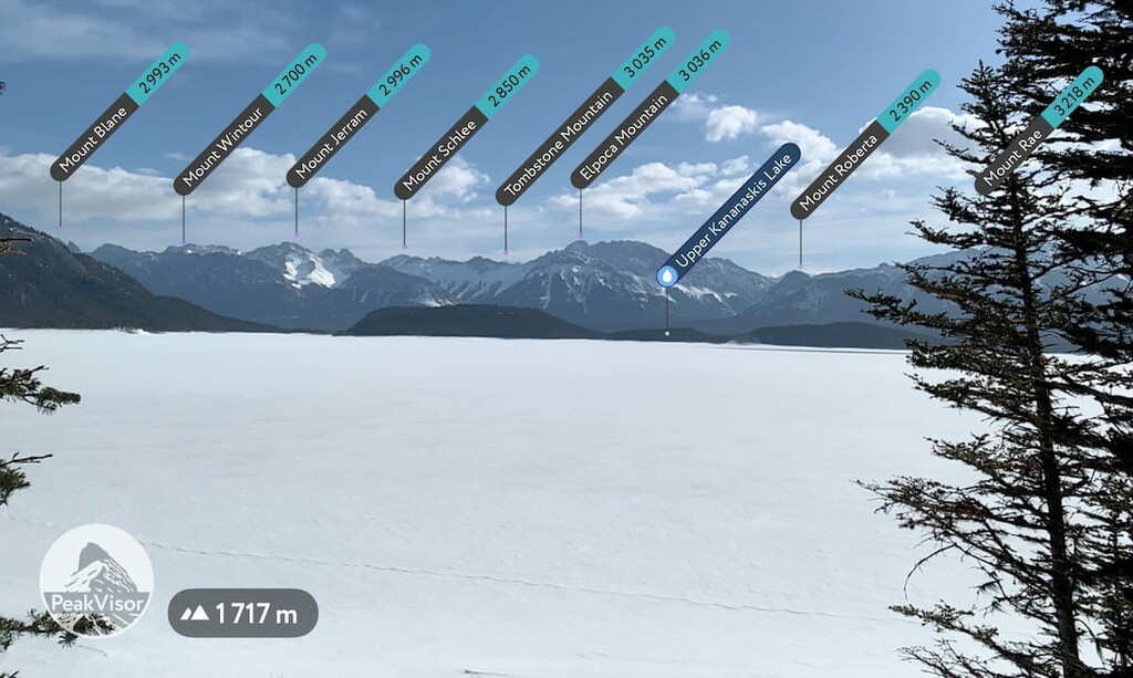
There are 33 named peaks within the range, the highest of which is Mount Evan-Thomas (3,097m/10,158ft). Other prominent peaks in the range are Elpoca Mountain (3036m/9958ft), which guards the southern tip of the range, and Tombstone Mountain (3035m/9954ft), which watches over the Elbow River Valley.
The Opal Range is roughly 70 km (44 mi) from Calgary, Alberta along Highway 40 (Kananaskis Trail). Running roughly north to south, the Opal Range starts with Gap Mountain and Wedge Mountain overlooking Wedge Pond in the north and continues south to Elpoca Mountain guarding the pass to the Elbow River Valley.
The Fisher Range is to the north of the Opal Range, while the Kananaskis Range is to the west, and the High Rock Range is to the south.
The range is accessible from the Evan-Thomas and Elbow Pass trailheads and many unofficial trailhead pull-outs along the east side of Highway 40.
However, there is a seasonal closure of Highway 40 from December 1 to June 15, into the Highwood Pass, south of Peter Lougheed Provincial Park, to protect wildlife. Cross-country skiing and cycling are still permitted along the highway and into the range past the gates during the winter months.
Hundreds of millions of years ago, the area that would become the Opal Range was covered by a shallow sea. Millions of sea creatures lived, died, and left their remains, some of which fossilized, and many of which were compressed into layers of limestone.
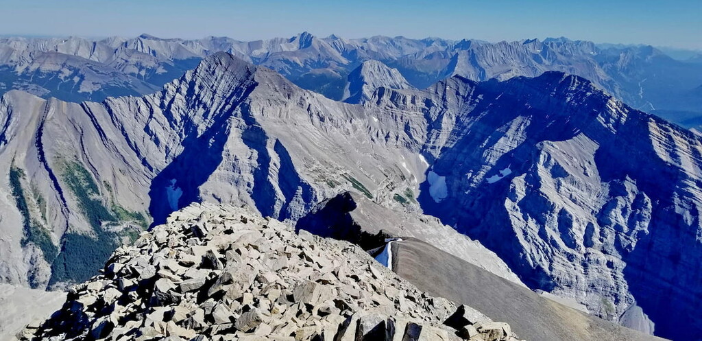
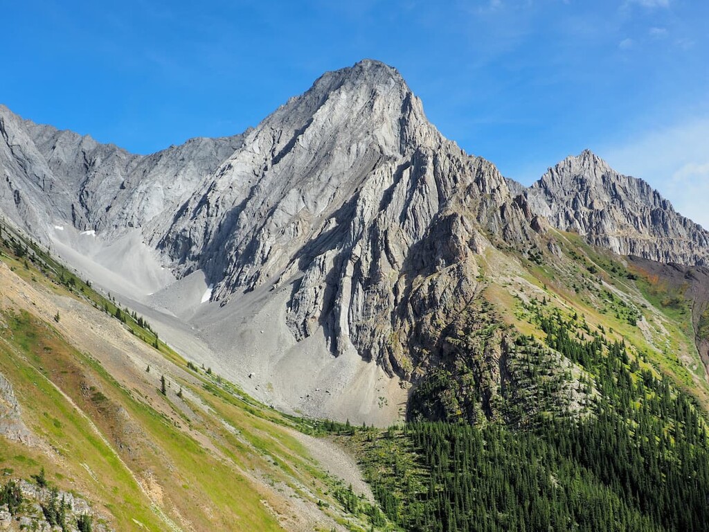
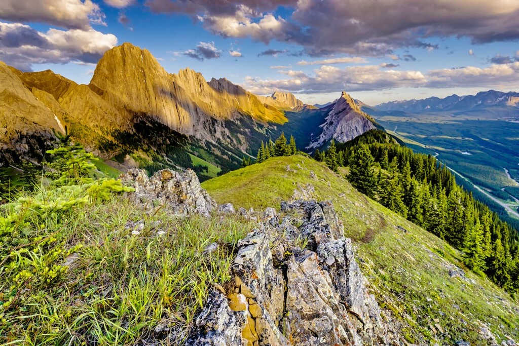
The Opal Range is characterized by its sawtooth profiles created by near vertically tilted layers of limestone, deep gullies, and steep limestone slab faces.
Composed mainly of limestone, the Opal Range has fossilized corals, oyster beds, shark teeth, and other evidence of ancient marine life. The range also has localized outcrops of conglomerate dolomite and metamorphic quartzite, adding some color and variation to the otherwise dull grey limestone.
The Laramide orogeny, the process which created the Rocky Mountains, started 70 to 80 million years ago and lasted for 15 to 50 million years. This period saw the tectonic plates from the west slide under the North American plates, deforming and rippling the landscape to form the Rocky Mountains.
Glaciers covered the mountains for millions of years and likely finally melted from the valleys only 10,000 years ago. There is strong evidence of glaciation throughout the valleys and upon the mountains, such as cirques, moraines, kames, and eskers throughout the valleys and slopes.
George Dawson named the range after he discovered small cavities lined with quartz and what he thought was a thin film of opal. It was not opal, but a chert with a similar appearance because of the quartz impurities embedded into the silica.
Despite the mistake, the name has stuck and the range has long been known in English as the Opal Range. Plus, Opal Range sounds better than Chert Range, in our opinion, anyway.
The Opal Range consists of jagged rocky peaks among its alpine habitat with steep rocky slopes. The slab slopes and rocky debris surrounding the mountains and the high-altitude valleys make the alpine zone of this range quite large, while the subalpine zone is forced low on the slopes and in the valleys.
Plants and animals are sparse in the alpine areas of the range and consist mainly of lichen covered rocks, grassy meadows, mat vegetation, shrubs, and krummholz. The rugged, saw-toothed mountain tops do not hold much soil for plants to grow in.
Mountain avens cling between the rocks to add a bit of color. Sedges, grasses, and mountain heaths cling to the edges of snowbeds while grouseberry and snow willow grow in protected areas. Stunted subalpine fir and Engelman spruce may be spotted amongst the rocky outcrops and grasses. Lengthy snow cover, cold temperatures, and the steep, rugged terrain prevent most flora from thriving amongst the peaks.
Birds are the only animals known to regularly inhabit the alpine areas. White-tailed ptarmigan, gray-crowned rosy finch, horned lark, and the American pipit are found in the area during nesting season.
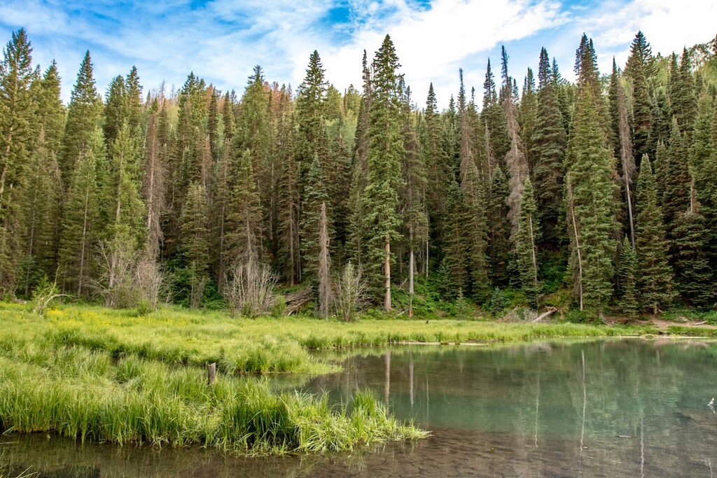
The subalpine region of the Opal Range is primarily contained to the valley floors. The rocky and rugged nature of the range does not allow for trees to grow far up the slopes. The valleys are full of lodgepole pine, alpine fir, and Engelmann spruce/white spruce hybrids. Grasses, willows, creeping juniper, and aspens fill the meadows around the valley creeks and rivers.
Large predators such as grizzly bears, black bears, cougars, and wolves make their home in the range. Ungulates, such as elk, mule deer, white-tailed deer, mountain goats, and mountain sheep are common to the range. Marmots scream from the rocks, while pika and ground squirrels chirp as they run along the boundary between the valley and the rocky slopes.
The headwaters of the Elbow River in this range are an important spawning habitat for bull trout, cutthroat trout, brook trout, and mountain whitefish. Cutthroat trout are stocked in several of the high mountain lakes and this area is considered important for maintaining native fish species.
Archaeological evidence suggests that human use and inhabitation of the Opal Range started at least 8,000 years ago. The Kootenai would pass the range on their way to hunt buffalo on the plains, and they were known to camp along the Kananaskis Lakes. The Stoney people have occupied the areas since the 1600s and retain rights for hunting, camping, fishing, gathering, and ceremonial use. The Tsuu T’ina also continue traditional use of the area.
James Sinclair was the first recorded European in the area, having arrived in 1841. He was followed by the Palliser Expedition in 1858.
With the Europeans came their tastes for wilderness tourism and adventure. By 1902, the Opal Range wilderness was preserved as part of Rocky Mountain National Park (now Banff National Park) to preserve it as an area for the conservation and protection of the natural landscape and wildlife habitat.
The area was placed under provincial jurisdiction in 1930 and has subsequently been managed by various organizations. The area was seen as a zone of prime protection for critical wildlife. The Opal Range now lies within the Kananaskis Country area that was designated and protected in 1978 and the range is specifically in Elbow-Sheep Wildland Provincial Park.
The wildland provincial parks allow for more diverse activities than the provincial parks. In addition to hiking, cycling, trail riding, and fishing that is permitted in the provincial parks, hunting, and commercial guiding and outfitting are permitted in wilderness provincial parks.
The wildland parks are intended to preserve large areas of wilderness and natural landscape for backcountry activities. The activities, as listed above, are supposed to be carried out in a way that minimizes interference with natural processes and retains the natural state of the landscape.
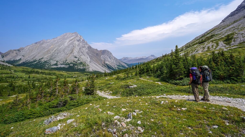
The Opal Range is a rugged range with some great recreation opportunities. It’s a place where you can hike, bike, ride a horse, fish, and hunt. There are several backcountry campgrounds in the range; however, policy states that random camping is also permitted (following some rules) and this allows you to explore this area with a large degree of freedom.
The Evan-Thomas Trail is a 13 km (8 mi) out and back trail that will lead you up along the Evan-Thomas Creek. This trail is accessible to hikers, bikes, and horses.
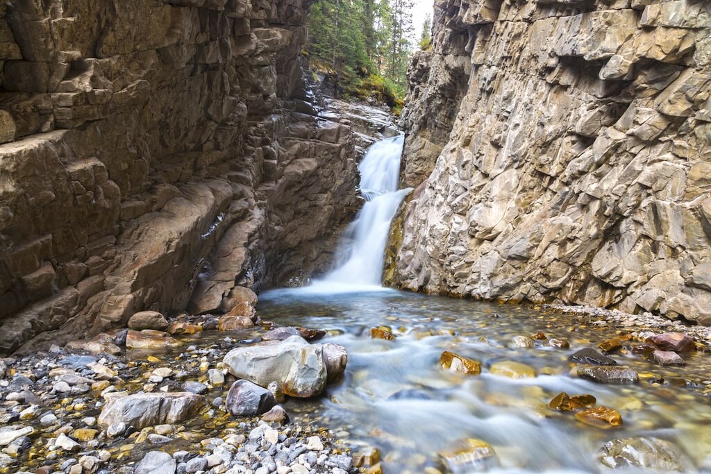
It is a moderate subalpine hike that can be done in all seasons, although wintertime is particularly beautiful. It’s a pleasant hike through the woods and along the creek to see waterfalls and some vantage points of Volcano Peak.
With the opportunity to hike past several frozen waterfalls, this hike is a real gem. If you’re fortunate, you may even encounter climbers as they tackle the frozen falls. There are many trails that branch off from the main trail, some of which take you past the waterfalls. You can hike a loop to take them all in and not double up on too much of the trail.
Elbow Loop is a 41 km (25 mi) loop that can start at the Elbow Lake backcountry campground near the base of Elpoca Mountain from the west or the campground in Little Elbow Provincial Recreation Area in the east off of Highway 66. It is a long trail that takes you through peaceful valleys and jagged peaks.
The hike is long; however, there are several campsites that you can stay at along the way to break it up over a few days. Many mountain bikers will ride this trail in a day or an afternoon. The trail is also popular for pack-riding with horses.
The loop will take you past Tombstone Mountain and around Banded Peak, Mount Glasgow, Mount Cornwall, and Elbow Hill. The scenery is both impressive and constantly changing as you turn down the different valleys.
The trail to the King Creek Ridge is a 7 km (4 mi) out and back trail. While steep in some sections, it is not a scramble but a moderate to difficult hike. It’s considered a grind to obtain the ridge; however, there are views to take in the whole way up.
The ridge is typically windy and can receive substantial snow packs during the winter. The trail is accessible in all seasons, however, snowshoes or traction aids are recommended in the winter.
Regardless of the season, the views are amazing on this hike. You’ll see the Kananaskis Valley below and the Kananaskis Range across the highway while you’re ascending and descending. Once upon the ridge, the Opal Range will open up to the east and the Fisher Range is visible to the north. This is a popular hike in the region.
This is a 1.4 km (0.9 mi) grind with 120 m (400 ft) of elevation gain up the slope of Elpoca Mountain. Though you grind up the trail, it isn’t that long, and since it's an old fire access road, the conditions make for easy hiking. This hike leads up to the Big Elbow Trail, the Elbow Loop trail, and Elbow Lake
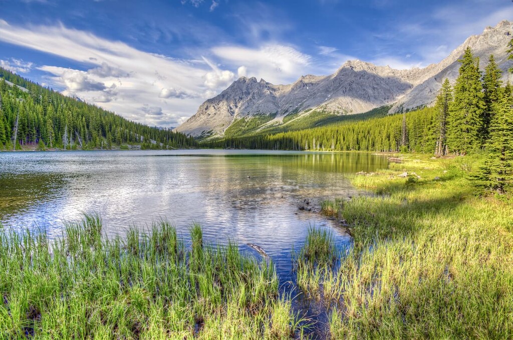
At the top of the hill you’ll find Elbow Lake. It is a pretty, little lake surrounded by forest and tall, rugged peaks. The southern shore hosts the backcountry campground with a unique treehouse-style outhouse. The lake is close enough that it is possible to haul up kayaks or canoes to use in the lake. There are fish to be caught too.
This is a family friendly trail that will push you, but the short distance and the great destination with lots to see and explore make the effort worthwhile. The Rae Glacier is located near this trail and it’s possible to hike up the glacier for summer snowboarding or skiing.
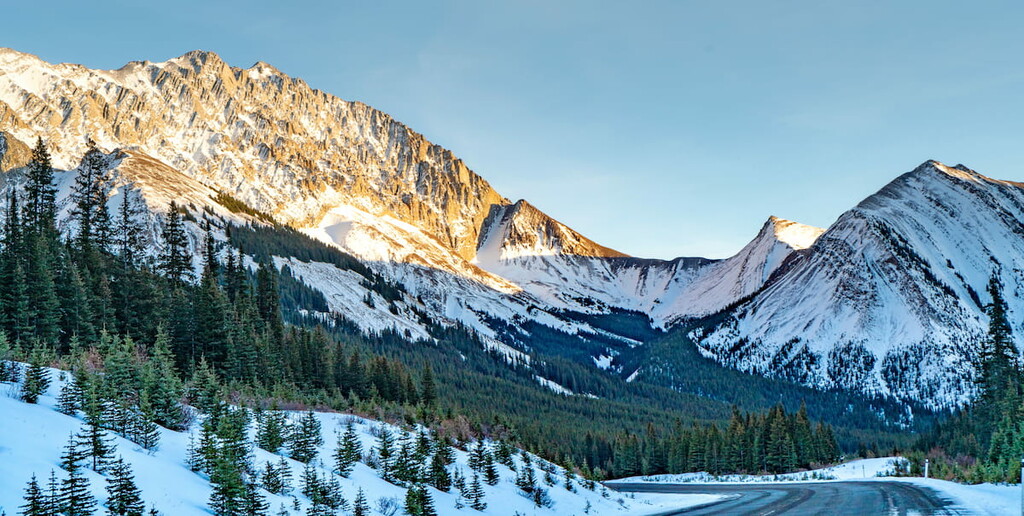
The Opal Range presents a unique view as you see it while travelling on Highway 40. It is imposing rippled ridges, sharp and jagged peaks, and massive near vertical slabs of limestone. It is a stunning mountain range to see, and fortunately, there are many camping facilities nearby in addition to towns and cities to venture from. Here are the closest towns and cities to stay in while exploring the range.
Located along the Bow River, just a short drive from the mountains, Calgary is a city with nearly 1.5 million people. Often seen as the gateway to the Rockies, many people are quickly shuttled from the airport out to Canmore or Banff.

The city does have an international airport with flights coming from all over the world; however, Calgary can be more than just a pit stop on your way to the mountains. It hosts a local ski hill along with winter sport training facilities. It has climbing centers to practice your trade, and you’ll likely notice the climbing center beside Highway 1 as you head west to the mountains as it has a prominent outdoor climbing wall.
In addition to training facilities, there are cultural and sporting events to see in the city. The Stampeders hit hard and give a good football game (we have only three downs, a bigger field, and bigger footballs than the games down south), while the Roughnecks lacrosse games are exciting with the quick pace and party like atmosphere in the stadium.
Calgary has excellent restaurants no matter your budget or preferences. During July, Calgary hosts the Calgary Stampede. There are cultural festivals throughout the year, and Spruce Meadows equine events take place each summer. Calgary has a lot to offer; however, its proximity to the Canadian Rockies is appreciated and a highlight for many residents.
Located 26 km (16 mi) south of Highway 1 on Highway 40, Kananaskis Village is an unincorporated community in Evan-Thomas PRA in the heart of Kananaskis Country. Accommodations range from a modest hostel to the more luxurious Kananaskis Lodge.
In Kananaskis Village, there are stores to buy supplies, food, and rent equipment. The village is also located at the base of the Nakiska Ski Hill and resort, which is a great winter destination.
Kananaskis Village offers hikes beginning right outside your door, such as Ribbon Lake and Troll Falls. It is a starting point for many groomed cross-country ski trails in the winter and it is the closest lodging to much of the backcountry skiing offered further south in Peter Lougheed Provincial Park.
The Kananaskis Country Golf Course is also located just south of Kananaskis Village. It was recently rebuilt after the 2013 floods which changed the face of much of Kananaskis Country. Since the fairways create enticing meadows, wildlife sightings are common, and bear spray is recommended. It’s well worth a visit.
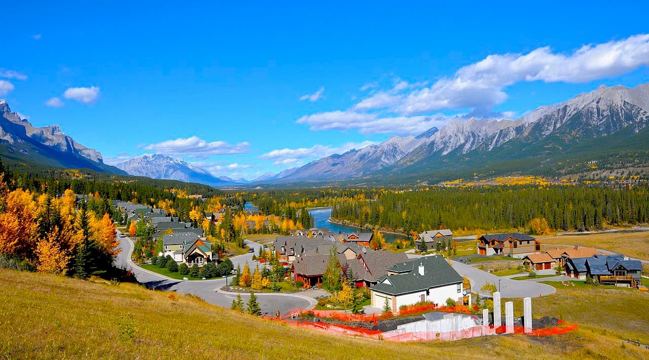
Nestled in the heart of the Bow Valley, Canmore, like many towns along the mountain railway, started as a coal mining settlement. It is located near the western edge of Banff National Park so it’s a good place to stay if you’re interested in exploring fun destinations and activities in the region.
Canmore provides easy access to hiking trails like Ha Ling Peak, Chester Lake and Grotto Canyon. In addition to hiking, Canmore offers ample opportunity for road and mountain biking.
The snow-filled months are typically the busiest months in Canmore, as it is a wonderful tourist town for the surrounding ski resorts, such as Sunshine and Lake Louise.