Scan the QR code and open PeakVisor on your phone
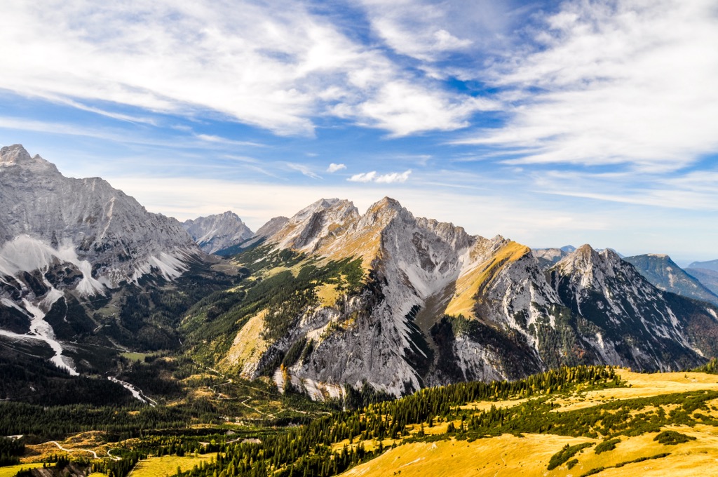
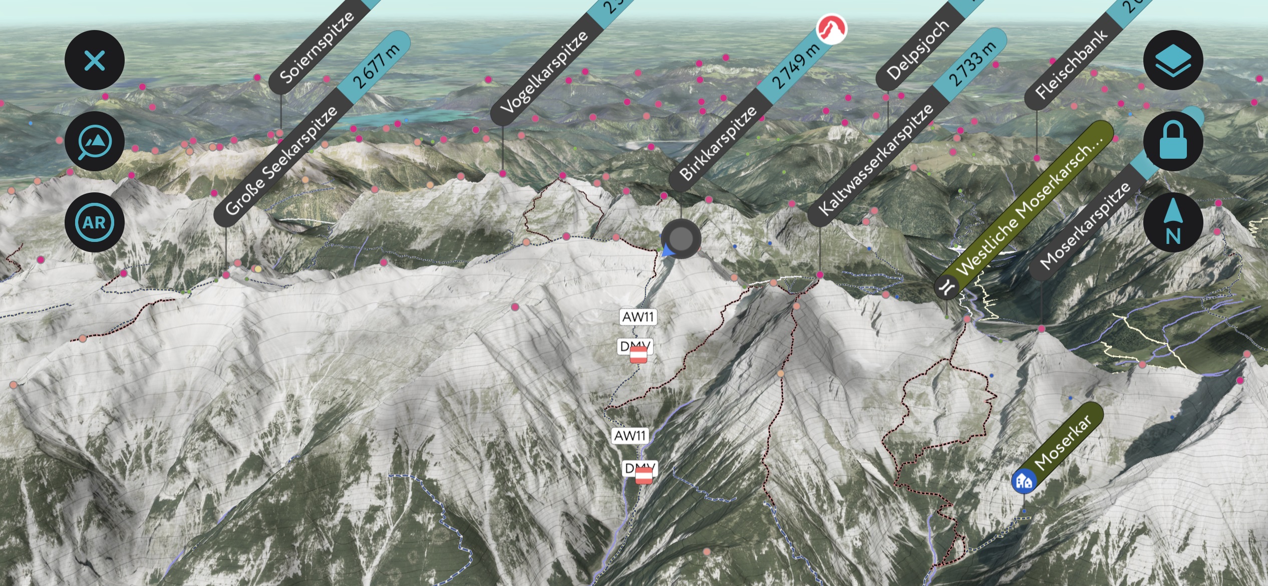
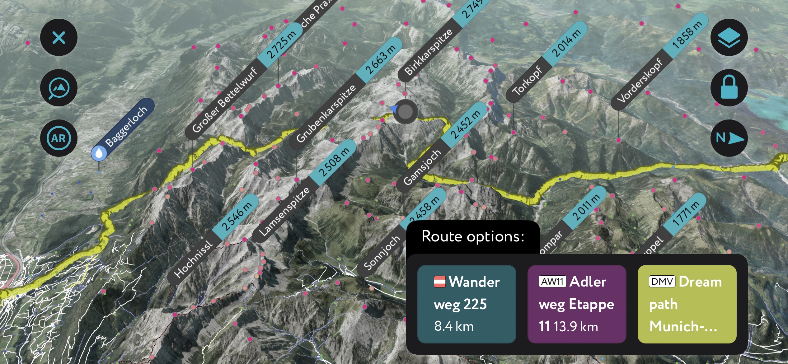
The Karwendel Mountains are an Alps subrange running between Inns Valley in Tyrol, Austria, and the Isar Valley in Bavaria, Germany. The range features jagged peaks and vast areas of undisturbed wilderness and rivers. The mountains are part of the North Tyrol Limestone Alps and are protected on the Austrian side within the Karwendel Nature Park. Birkkarspitze (2,749 m / 9,019 ft) is the highest and most prominent peak, rising 1,565 m (5,135 ft) from its surroundings.
The Karwendel mountains are located in Tyrol in northern Austria and reach into the Bavarian region of Germany. The range runs between the Inn River in the south and the Isar River in the north. To the west, it’s neighbored by Seefeld Saddle and to the east by the Achensee lowlands and Lake Achensee.
The range is a valuable conservation area with its steep peaks, limestone cliffs, cirques, old forests, and undisturbed rivers. Some peaks rise almost 2,000 m (6,560 ft) vertically in less than 4 km (2.5 mi) horizontally; the mountains are steepest in the inner and southern parts.
The Karwendel area, though a subrange of the Alps, is composed of even smaller ranges, including the Solstein mountains, the Gleirsch-Halltalkette, the Northern Karwendel Chain, and the main Karwendel ridge known as the Hinterautal-Vomper Chain. The Wetterstein and Mieminger mountains neighbor Karwendel to the west, while the Brandenberg Alps lie to the east.
The mountains are contained within the Karwendel Nature Park on the Austrian side. It is the largest nature park in Austria at 727 sq km (281 sq mi). On the German side, the mountains are part of Naturschutzgebiet, with less protection than a “Nature Park” but a protected area nonetheless.
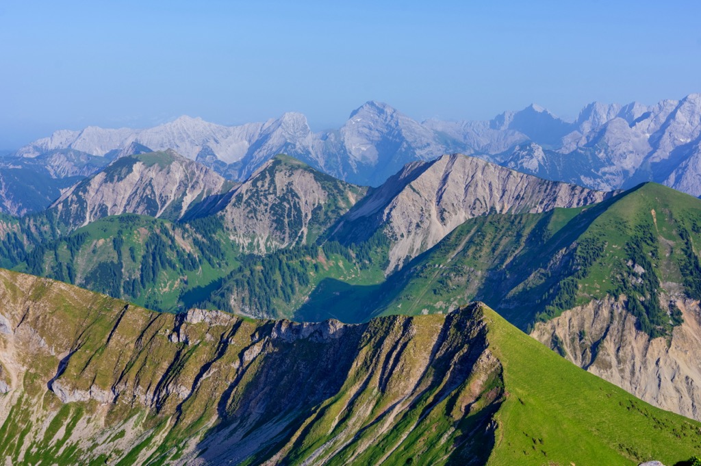
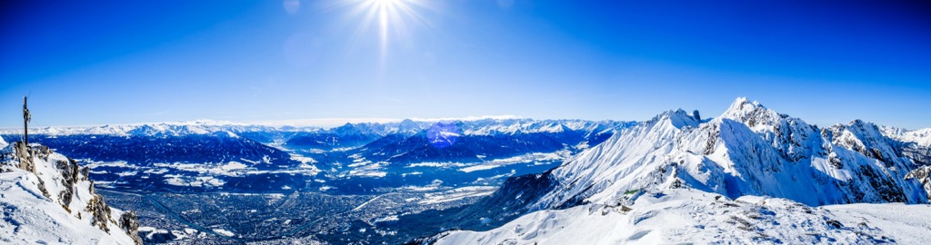
The Karwendel mountains are part of the Alps, specifically the North Tyrol Limestone Alps. As the name suggests, the peaks are composed primarily of limestone and other porous rocks such as dolomite, marl, and sandstone. Break lines along the main ridges create vertical rock faces, some up to 1,000 m (3,280 ft) tall. Along the southern side are several cirques – large, alpine bowls formed by ancient glaciers. No glaciers remain in the Karwendel; unlink the neghboring Wildspitze massif, which supports extensive glaciation, the Karwendel doesn’t have enough high alpine terrain for perennial accumulation of snow and eventual formation of ice.
The Alps formed during the Alpine orogeny, a mountain-building event that occurred as the African and Eurasian plates collided and has been ongoing since Cretaceous times. Most mountain building occurred between 65 and 2.5 million years ago, although the mountains continue to be uplifted. However, the uplift rate no longer outpaces erosion, and the Alps are not considered a growing range. Additionally, geologists have attributed the recent uplift to a rebounding effect as the Alps spring back after the weight of the last ice age’s ice sheet melts away.

Karwendel contains a “golden spike,” a unique geological marker of which there are less than 70 worldwide that designates a clear transition spot between two geological eras. In this case, the spike is located near Kuhjoch and the village of Hinterriss, about 25 km (15.5 mi) northeast of Innsbruck. Here, the rocks and fossils show a clear transition between the Triassic and the Jurassic eras.
Meanwhile, the range’s Limestone and dolomites formed during the Mesozoic and tertiary eras. While Karwendel has comparatively few caves, it does have surface karst features. Glaciers have been the dominant force in more recent geological history.
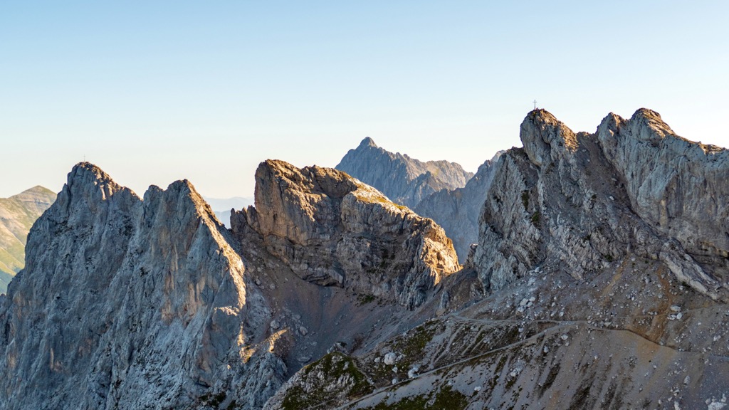
Common characteristics of the Karwendel include sheer limestone cliffs, glacial moraines, and enormous scree fields. Talus fields wind down the mountains, and new material flows downwards during heavy summer rains.
There are Triassic reefs rich in fossils north of Innsbruck and mineral deposits throughout the range of lead, zinc, oil shale, and salt. The trademarked Tiroler Steinöl is mined from oil shale around Pertisau and used for high-end cosmetics.

The Karwendel Mountains have long been recognized for their ecological richness. The high country is subject to cool, wet summers and long, snowy winters. Snow cover can remain for eight to ten months; the high peaks typically receive between two and eight meters of snow. Precipitation ranges from around 90 to 210 cm (35 to 83 in).

The area’s steep terrain has deterred significant human development, allowing natural processes such as avalanches, mudflows, and water to continue shaping the landscape. While humans have modified many streams and rivers in Austria, the Karwendel Mountains retain an impressive number of natural freshwater ecosystems, including 24 streams measuring over 200 km (125 mi) in length, around 100 tributary streams, and hundreds more small creeks and wet gullies.
The variation in precipitation and altitude over a short horizontal distance supports diverse ecological communities.

Forest ecosystems within the Karwendel Mountains include deciduous, conifer, and mixed forest communities. Common tree species and pairings include beech-fir, spruce-fir, larch-spruce, sycamore maple, and willow, grey alder, and ash in riverine forests. Other plant species growing in the mountains are German tamarisk, many types of the Gentiana flower, and orchids such as lady’s slippers.
One of the range’s keystone ecozones is the dwarf mountain pine scrub dominated by Pinus mugo, which plays a critical role in maintaining the landscape’s integrity and natural processes. These include serving as a sink for raw humus in soil formation, stabilizing against erosion, deterring avalanches, and influencing the hydrological systems of the mountains.
Other terrestrial ecosystems include peat bogs, reedbeds, wet meadows, rock and scree fields, and alpine zones.

The Karwendel Mountains support rich and diverse wildlife thanks to low human impact. Over 3,000 species are estimated to live in the range, including over a thousand beetles and 700 butterfly species. Riparian areas and surrounding gravel areas support rare spiders. There are three snake and four lizard species, including the Croatian rock lizard and the alpine newt.
Many birds nest and breed in the mountains. Golden eagles thrive at a relatively high concentration. Pygmy and Tengmalm’s owls are drawn to the old-growth forests. Woodpeckers include grey-headed, white-backed, and three-toed varieties.

Several birds make their homes in rocky crevices, such as the alpine chough, Eurasian crag martin, wallcreeper, and alpine accentor. Forest birds include the Eurasian woodcock, ring ouzel, and several warbler and songbird species, including the citril finch, lesser whitethroat, dunnock, and common redpoll. Parts of the mountains serve as breeding grounds for the common sandpiper, endangered in some parts of Austria.
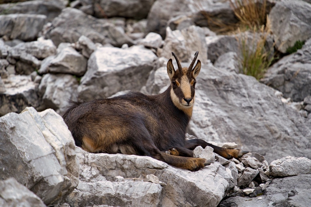
As for mammals, chamois colonize the high country’s forest and alpine meadows, while ibex might be spotted around Sonnjoch. Marmots, red deer, hare, 25 species of bats, and the endemic Bavarian short-eared vole make their home here. Historically, the region supported brown bears and lynx; the habitat is well-suited for these larger mammals. However, both mammals require extensive territory, and population density will likely continue to hinder their re-introduction.
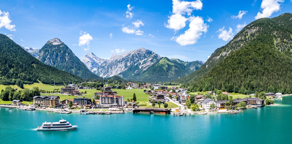
The Karwendel Mountains and surrounding valleys have been valued for centuries for their abundant natural resources and conservation value. Lake Achensee became famous in the 1400s, serving as Emperor Maximillian's hunting and fishing grounds. Commercial tourism began in 1887, with ships built to carry guests around the lake. The lake has been used for generating hydropower since 1927.
Shale oil has been extracted around Lake Achensee for centuries and is used for cosmetic products. Halltal, north of Hall in Tirol, was a salt mining center during the Middle Ages. Some of the old mining tunnels remain.

Innsbruck was home to the Habsburg emperors in the 1500s and sat at an important junction of trade routes. The mountains have provided drinking water to the city since 1486.
Alpine pasture farming was first recorded in the area in the 12th century. Although tourism is the primary economic driver, pasture and dairy farming continues today, along with some forest management and hunting. The central part of the Karwendel massif first received a conservation status in 1928. Today, the nature park receives around one million visitors annually.
Karwendel offers countless day hikes, multi-day treks, ski slopes, and climbing routes. Mittenwald, Scharnitze, Seefeld, Pertisau, and Hall in Tirol are the most common spots to access the mountains. You’ll find popular fixed rope hiking routes in Innsbruck and Mieming.
Some of the top attractions in Karwendel Nature Park are Isar spring, Laliderer wall, Hafelekar with a natural “window” overlooking the range, Wolfsklamm gorge, and the historic salt mining center of Halltal. The Great and Small Ahornboden are home to an old-growth stand of more than 2,000 sycamore maples over a century old.
Karwendel is less famous as a ski destination as other parts of the Alps. Still the region receives abundant snowfall and offers excellent skiing. Among the top ski resorts in the region are Christlum-Achenkirch, Nordkette-Innsbruck, Planber Pertisau, and Wisenlifte-Pertisau. The Dammkar ski route from Mittenwald is Germany’s longest ski run at 7 km (4.3 mi) long.
Visitors should note that camping is not allowed in Karwendel Nature Park. Overnight visitors can stay in mountain huts and should make reservations at least three to four weeks in advance.
The hike up Baerenkopf (1,991 m / 6,532 ft) is around 11 km (7 mi) out and back with 1,065 m (3,500 ft) of elevation gain. Hikers should be prepared for steep sections, but the summit hike along Lake Achensee is beautiful and takes in views across the lake, Rofan, and Karwendel. The area is also an excellent spot for cross-country skiing during the snowy months.
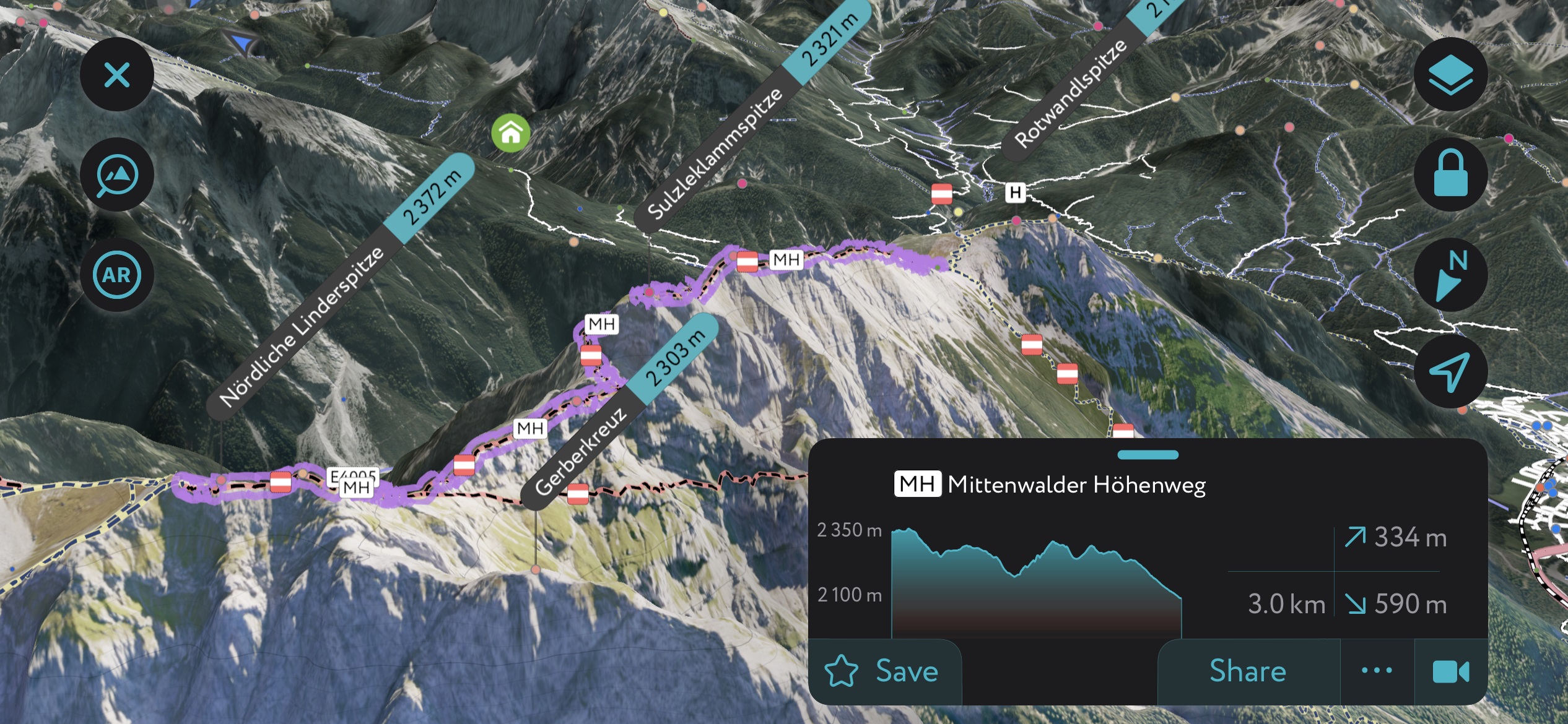
This three-day route is a Karwendel classic, running west to east through the Karwendel mountains. It’s 53.5 km (33 mi), has just shy of 2,400 m (7,874 ft) of elevation gain, and is considered a moderate trail (by Alps standards).
One of the trail's highlights, in addition to the usual breathtaking views of the Karwendels, is the Kleiner Ahornboden. This high valley is tucked in the midst of the mountains and is covered with thousands of maple trees over a century old. Overnight, hikers will stay at Karwendelhaus and Lamsenjochhütte, cozy huts high in the mountains.

One of the most classic adventures through the Karwendel mountains is a six-day hut-to-hut hike from Mittenwald to Pertisau. It is approximately 60 km (37 mi), with around 7,000 m (22,965 ft) in elevation gain. The route traverses high alpine, climbs multiple summits, and winds along rivers.
Each part of the hike varies in difficulty. Day 1 from Scharnitz to Hallerangerhaus is easy, and the final day from Nördlinger Hütte to Reith bei Seefeld is only slightly more challenging. Some sections are difficult, and those who want to push themselves can tack on ascents to Speckkarspitze on Day 2 and Stempeljochspitze on Day 3.
The Munich-Venice trail is an epic route between the cities that spans 550 km (340 mi) with 20,000 m (65,615 ft) of elevation gain. It crosses through the Karwendel on days five, six, and seven of the longer route. Parts of this are particularly challenging, with many ascents and descents over rough terrain. It is suitable only for experienced hikers.
The Karwendel is well-known for its via ferratas – aided climbing routes protected with fixtures like railings, cables, and ladders. The name means “iron way” in Italian; these routes originated as a way for soldiers to pass through mountainous terrain. The via ferratas range in difficulty, with many options. One impressive route is the Innsbruck fixed-rope route, also known as the Hannes Gasser Route. It begins at Hafelekar and is accessible from Innsbruck by the Nordkette cable car. This challenging route summits seven peaks and traverses the narrow Seufzerbrücke (the Bridge of Sighs), and includes several vertical climbs.
The Mittenwald High Trail is an easier option that is a combination hiking trail and via ferrata. It offers panoramic views of the Wetterstein Mountains and Karwendel. The climb is relatively easy, and people usually complete the 12 km (7.5 mi) route in eight hours.

Winter brings the chance for ski touring through the Karwendel. Routes range from several kilometers to overnight excursions. One scenic tour runs from the Eppzirler Tal Valley to Kuhlochscharte. It is a challenging 17.5 km (10.9 mi) route and is often in condition from winter to spring. Due to the steep slopes, it is not ideal to go in fresh snowfall or other times of high avalanche danger.
Another demanding route is an 18.7 km (11.6 mi) tour from Scharnitz to Pleisenspitze. After climbing around 1,600 m (5,250 ft), the views from the summit of Pleisenspitze and the smooth descent are all the more appreciated.
Beginners or those looking for a more leisurely tour could try the Achenkirch plateau route to Hochplatte. It is 4.8 km (3 mi) with 806 m (2,644 ft) of elevation gain and takes around two and a half hours. The trail leads through the forest and past the hut Falkenmoosalm before summitting Hochalmplatte, with a mellow descent.
The only permanent settlement in the Karwendel Nature Park is the village of Hinterriß. The range is typically accessed from Mittenwald in the Bavarian Alps or the small village of Scharnitz near the border in Austria. Several valleys from Scharnitz lead into mountains, including Isar Valley.
Another access point to the mountains is the resort town of Pertisau. Habsburgian kings and nobles historically frequented it, while today it receives many wellness tourists. Skiing areas around Lake Achensee are usually small-scale and versatile with plenty of wide slopes for families and beginners. The Karwendel cable car leads from Pertisau to the ski area Zwölfkopf. Innsbruck and Munich are two larger cities located near the mountains.
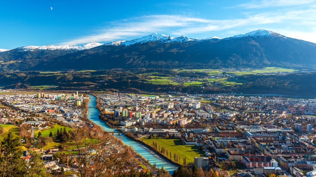
With a population of over 310,000 people, Innsbruck is an excellent destination for culture, nature, and proximity to mountain sports. It is the second-largest city in the Alps, after Grenoble, France, but arguably offers better mountain access. The city lies in a valley with steep mountains rising steeply around it; cable cars like the Nordkette and Patscherkofel provide quick access to the slopes for hiking, skiing, mountain biking, and paragliding.
Visitors can stroll through Old Town or pay a few Euros to climb the Town Tower. The Hofkirche church has 28 bronze statues, while the Cathedral of St. James shows off Baroque architecture. The Schloss fortress, a medieval fortress turned Renaissance castle for Archduke Ferdinand II’s wife, displays armor and artwork. Innsbruck hosted the Winter Olympics in 1964 and 1976 and the 1984 and ‘88 Winter Paralympics; the stadiums still host sports events.
Purchasing an Innsbruck Card is a worthwhile investment if you want to go to multiple museums, ride some cable cars, and have free transport on buses, trams, and bikes. The passes can be purchased for 24, 48, or 72 hours.
Innsbruck is within a 30-minute drive from both Italy and Germany. It is possible to arrive by train from Venice, Munich, Salzburg, and Zurich. The city also has a small but busy international airport and is a launching point for the famous Tyrolian ski resorts.
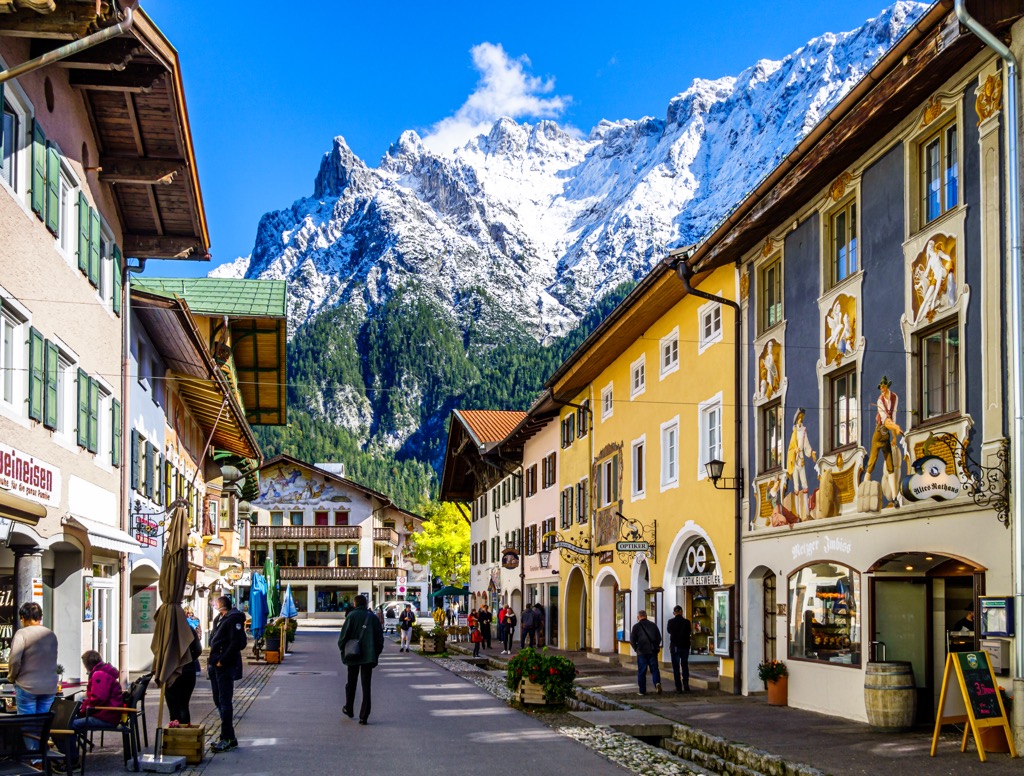
Mittenwald has a population of around 7,500 people and is 65 km (40 mi) south of Munich. It is a quiet but charming town. The house exteriors boast colorful mural paintings in a style known as Lüftlmalerei, specific to southern Germany and Austria, and the town is famous for the art of violin-making. Manufacturing began in the mid-1600s by the Klotz family when the father brought skills he learned in Italy; the museum Geigenbaumuseum dives into the instrumental history.
The Mittenwald Church is a 14th-century church of Saint Peter and Paul. Although it is not as ornate as other city churches, it’s worth passing by to appreciate the mural paintings that give the illusion of three dimensions.
The Karwendelbahn cable car is the second highest in Germany and climbs to 2,000 m (6,560 ft). The summit offers a restaurant, an information center, and the starting point for several hikes in the Karwendels. In winter, experienced skiers shouldn’t miss the Dammkar ski route. It is Germany's longest ski route at 7 km (4.3 mi) and descends 1,300 m down to Mittenwald.
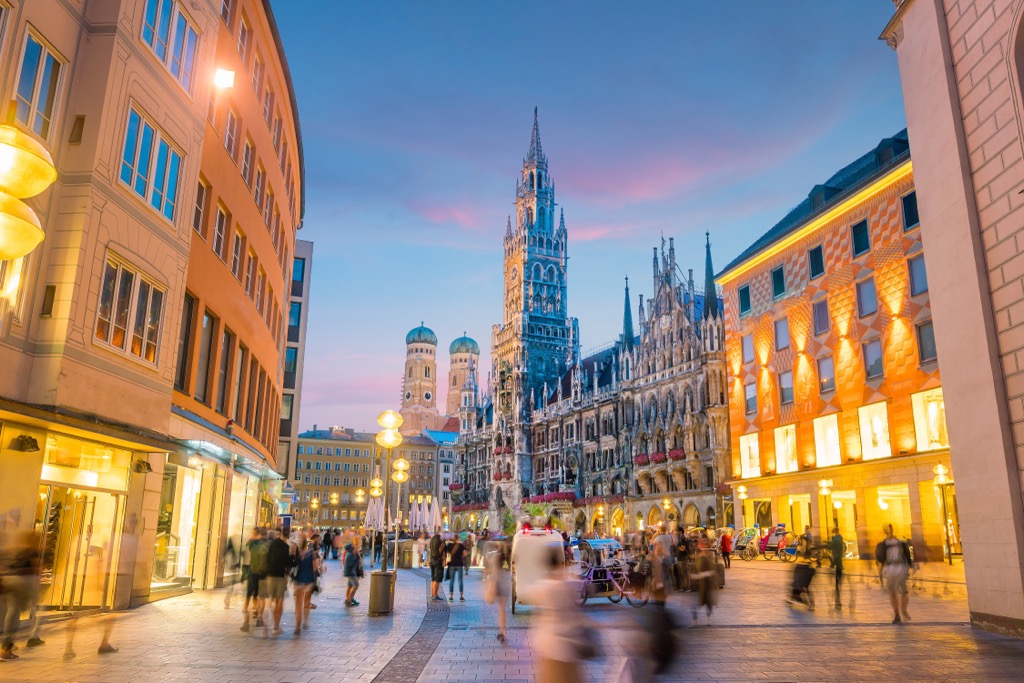
Munich has a population of 1.47 million and is in southern Germany. It is about two hours from the Karwendel mountains. With cobbled streets, historic buildings, and plenty of restaurants and bars, the city is urban with a charming, historical feel.
Be sure to visit one of the boazn, a genre of local dive bars well-known for their breweries and Oktoberfest celebrations. The city has many museums, from art galleries to more unique museums such as the Potato Museum (Kartoffelmuseum) and the Hunting and Fishing Museum (Jagd- und Fischerei-Museum). Many museums offer cheaper entry on Sundays.
Check out local farmers' markets year-round and the Christmas markets around the holidays. With excellent public transportation, it’s easy to navigate the city and get out to surrounding areas without having your own car.