
Scan the QR code and open PeakVisor on your phone
Nestled in northern Taiwan’s Yilan County (宜蘭縣) is Shuanglianpi Lake (雙連埤湖), the centerpiece of Shuanglianpi Major Wildlife Habitat. Sanzenhoushan (三針後山), the only peak in the area, measures 815 meters (2,674 ft) in elevation.

Shuanglianpi Major Wildlife Habitat (宜蘭縣雙連埤野生動物重要棲息環) is located in the remote Huxi Village (虎溪里) of Yuanshan Township (員山鄉) in Yilan County of Taiwan. The entire wetland habitat covers an area of 634 ha (1,566 acres), while the lake covers an additional 17 ha (42 acres).
One of Yilan’s top five bodies of water, Shuanglianpi Lake is known for its incredible biodiversity. The four remaining lakes in the area are Cuiefong Lake (翠峰湖), the highest elevation lake in Yilan and Taiwan; Longtan Lake (龍潭湖), Yilan’s largest lake; the flower-shaped Meihua Lake (梅花湖); and Da Lake (大湖).
Shuanglianpi Lake sits at an elevation of 470 meters (1,542 ft). The name Shuanglianpi translates as ‘two joined lakes;’ thus, two bodies of water that form the lake are interconnected. The larger lake measures 8 ha (20 acres) and has a depth of 1.5 meters (5 ft), with the smaller lake measuring 2 ha (5 acres) and is 1 meter (3 ft) deep.
Situated between the two conjoined lakes is an interesting natural phenomenon: temporary floating grass islands formed by Shuanglianpi’s abundant aquatic plants. During the rainy season, the islands are washed away by intense torrents, but they reappear once plant growth has accumulated underwater to create new drifting islets.
With an annual average rainfall of 4,000 mm (157 in) and a yearly mean temperature of 18.5°C (65°F), Shuanglianpi Major Wildlife Habitat experiences a wet and humid climate.
Set in a valley, Shuanglianpi Lake’s constant veil of mist rises high above the water, as the forested hills in northern Taiwan retain the fresh, cool air that blows off the Pacific Ocean. Shuanglianpi’s landscape of rolling emerald hills is extraordinarily picturesque; thus, local movie makers have used Shuanglianpi as a set for numerous films.
One of Shuanglianpi’s most striking features is that its lake contains the greatest distribution of aquatic plants in Taiwan. In fact, Shuanglianpi’s plants account for one-third of Taiwan’s aquatic plant species.
Many well-known scenic attractions surround Shuanglianpi Major Wildlife Habitat, too. Taipingshan National Forest Recreation Area (太平山國家森林遊樂區) is located in the south, while Fushan Botanical Garden (福山植物園) lies to the west. To the east is the coastal Yilan City (宜蘭市) while New Taipei City’s (新北市) Beishi River (北勢溪) flows to the north.
The hills in Shuanglianpi Major Wildlife Habitat are part of the northern extension of the Xueshan Range (雪山山脈). The second longest and second largest range in Taiwan, the Xueshan Range extends from Taichung City (臺中市) in the southwest to North Taipei City in the northeast and it encompasses 1,233 peaks.
The one peak in the wildlife habitat, Sanzenhoushan is a small and relatively gentle mountain when compared to the rugged peaks of the Xueshan Range that are found in central Taiwan’s Shei-Pa National Park (雪霸國家公園).
Geologically, the landscape in Shuanglianpi mainly consists of a mixture of gravel, sand, and mud that dates to the Holocene.
Shuanglianpi is home to 202 species, of which 56 species are aquatic plants. Moso bamboo, Salix kusanoi, and Taiwan hemlock are endemic plants found in the area. Furthermore, Shuanglianpi Lake is a haven for rare plant species, such as Salix kusanoi and frogsmouth.
The incredible biodiversity of Shuanglianpi Lake makes it an attractive habitat for wildlife. Nine fish species inhabit the lake, such as the mosquitofish, Japanese rice fish, and the rare golden carp. The rare Asian yellow pond turtle shares the waters with the fish, too.
Shuanglianpi Major Wildlife Habitat is also a haven for the 49 species birds that call the area home, such as the Taiwan blue magpies, Taiwan yuhinas, gray herons, and the Formosan laughing thrush.
Shuanglianpi’s land was once privately property, and its owner was unaware of the wetland’s significant biodiversity; thus, the habitat was damaged due to land development. Once the land went up for sale in 1991, the government of Yilan County bought it to preserve the wetland’s unique ecology and for environmental research purposes.
In 2003, Taiwan’s Council of Agriculture established Shuanglianpi’s rich resources as a major wildlife habitat under the Wildlife Conservation Act.
Here are some of the major hiking trails and areas located in and around Shuanglianpi Major Wildlife Habitat.
Shuanglianpi's signature trail, the 3 km (1.8 mi) Shuanglianpi Lake Hiking Trail, traces the park’s lakes and explores various ecosystems en route.
Starting from the Shuanglianpi Ecological Classroom, you will quickly enter a red pine forest. From here, a Chinese fir woodland awaits before you reach the Shuanglianpi Lake's enchanting misty waters.
It is beyond impossible not to get swept up in the lake's stunning setting, as verdant, rippling hills border the landscape. The environment's emerald cloak covers the fertile region with lush forests, countless aquatic plants, and the floating island's grassy magic carpet.
As you wander around the lake's edge, you may observe mandarin ducks gliding through the calm, cerulean waters while spotting countless other birds grazing in the lakeside trees. In addition, the clear waters show the diverse marine life, and you may even spot a rare Asian yellow pond turtle swimming in the water.
Located just a short journey from Shuanglianpi Major Wildlife Habitat is the Fushan Botanical Garden. Situated on the boundary line between Yilan County and New Taipei City, Fushan Botanical Garden is Taiwan’s largest arboretum at 410 ha (1,013 acres) in size. It is home to over 700 plant species.
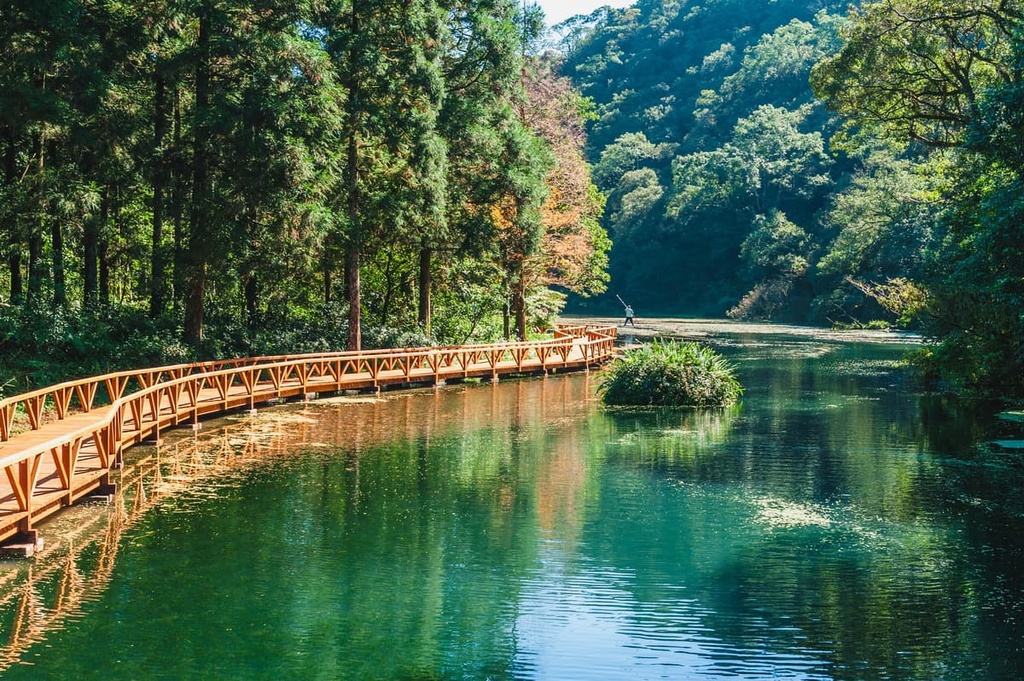
A 20 km (12 mi) path leads you through a pristine, picturesque lakeside course where the evergreen pine needles brush the lake’s turquoise waters. Walking on the wooden boardwalk, you feel enveloped in a lush, leafy world as the murky lake, flourishing forest, and verdant hills offer an abundance of greenery to the landscape.
Further along the trail, you will encounter a lavish variety of temperate broad-leaved plants, such as Taiwan phoebe, Taroko oak, Japanese soapberry, and wheel tree. As Fushan’s elevation ranges between 600 to 1,400 meters (1,969 to 4,593 ft), the forest belt transforms into a coniferous woodland as the elevation rises over 1,000 meters (3,281 ft). The camphor tree and Taiwan yew dominate in the higher elevation zones of the region.
In springtime, Taiwan’s 16 native rhododendron species bloom in the same space, making it a true wonder to behold. They flourish in a rainbow of colors from soft lilacs to deep reds, sunshine yellows, and pretty pinks, which is a fantastic sight to see.
Once a thriving agricultural region, Cherry Blossom Road has been transformed from its industrial past to a popular recreation area for hikers and nature lovers. As its name suggests, the scenic path is adorned with spring’s showpiece, the pastel-colored cherry blossoms.
In late February, the cherry blossom’s magical beauty begins to flourish, adding an element of soft blushing pink to the jade-green landscape. The best time to visit Cherry Blossom Road is during the spring months.
A 4 km (2.4 mi) trail leads you through a dense camphor woodland where you can forest bathe amongst the trees. Forest bathing is a term coined by the Japanese, and it is the process of spending time in nature to lower one’s stress hormones by inhaling the calming effects of phytoncide.
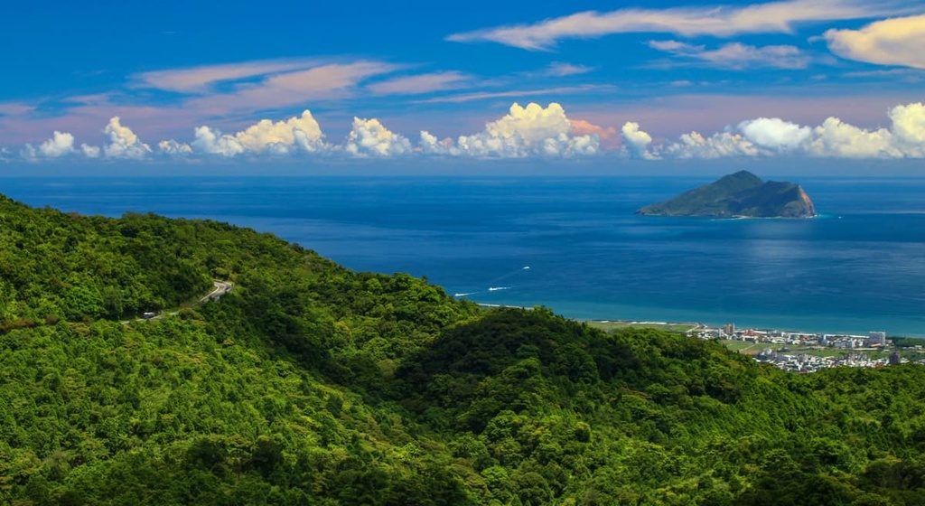
The path ascends Bengshanhushan (崩山湖山) from where you can admire the fertile Bengshan valley from a viewpoint that overlooks Yuanshan Township. On a clear day, you can even see as far as Guishan Island (龜山島) from the summit.
This lesser-known gem of Lengpi Lake (冷埤) is tucked away in the hills of Daanpishan (大安埤山). It is so remote that visiting the divine lake entails a rugged 8 km (5 mi) trek.
Starting from the Daanpishan Trailhead, you will soon encounter a path leading through the sheltered, unkept foliage of moon peach and yellow trumpet vine plants. The network of vines, branches, twigs, and leaves create a natural obstacle course where you have to crawl and climb your way through the undergrowth.
Soon afterwards, a dense plumage of eye-level ferns swarms the environment, which you may need to cut to progress on the path. Once through, the intensity of the course’s vegetation becomes more manageable, and climbing to Daanpishan’s summit will feel effortless after the laborious climb.
Daanpishan provides a clear and unspoilt view of Yilan City and its surrounding areas. You can see the Central Mountain Range (中央山脈) in nearby Su’ao Township (蘇澳鎮) in the distance while also catching a glimpse of Yilan’s Jinche Winery and Kingar Orchid Garden.
You will then head downhill and make your way towards Lengpi Lake, a mesmerizingly clear pool. A true slice of paradise, Lengpi’s scenic charm can melt any heart as a luscious acacia forest embraces the serene crystal waters. The aquatic plant, ricefield bulrush, grows in abundance here, as it shoots out above the sparkling waters. Visitors love to dip their feet in the refreshingly cool pond, where red mud carp and remora swim.
Another of Yilan’s lakes, Taiyanpi (太陽埤), is shaped like a heart. The Taiyanpi Trail does not circle the lake; instead, it ascends Taipyanpishan (太陽埤山), which overlooks the romantic aquamarine lake.
The route is covered with fallen trees and wild overgrowth. Not many people frequent the trail, but this is advantageous as the nature and landscape are both secluded and unspoilt. As you gain elevation, you will notice the sparkling sapphire lake enveloped by three hills.
On Taiyanpishan’s summit at 187 meters (614 ft) in elevation, you can enjoy a view over Yuanshan Township and Yilan City. You can even distinguish the turtle-shaped Guishan (龜山) in the far distance off Yilan’s coast.
While hiking, keep an eye out for egrets swooping onto the lake in the hopes of catching their next meal. Also, the rare, red-crowned cranes have been spotted in the wintertime at the lake as part of their migration.
Yilan City and New Taipei City are the two closest cities to Shuanglianpi Major Wildlife Habitat, and they both make for great basecamps during your adventures. Here’s what you need to know about each city.
While Yilan City cannot compare to Taipei’s (臺北市) electric nightlife and unlimited options, there is beauty in every corner, and it is one of Taiwan’s most charming regions. There is an abundance of unspoilt, enchanting nature spots to visit in Yilan for anyone looking for a more relaxing adventure.

Undoubtedly one of Yilan’s top attractions, Taipingshan National Recreation Forest Area shares the spotlight with Alishan (阿里山國家森林遊樂區) and Basianshan (八仙山國家森林遊樂區) as one of Taiwan’s top three largest alpine forests. Here, woodlands of Taiwan red cypress and Taiwan cypress trees densely populate the landscape. You can also see Cueifong Lake, Taiwan’s highest pond in the recreation area.
Another great place to check out near the city is the picturesque Wufengqi Scenic Area. With its sleek 100 meters (328 ft) three-layered Wufengqi Waterfall, the sound of flowing rapids mixed with the merry chirping of birds and insects create an idyllic soundtrack of nature. Wufengqi’s five hills are densely cloaked with verdant forest, too.
Another one of Yilan’s spectacular spots is the Dongshan River Water Park. Known for hosting the annual Dragon Boat Race Festival in Yilan, Dongshan River Water Park’s setting is the main attraction for visitors. Yilan’s coastal peaks flank the serene riverway, reflecting in the cerulean, still waters. A walking trail and a bike path trace the riverbank’s flourishing forest for you to explore the lusciously lavish land.
To enjoy a Taiwanese staple and a popular mode of relaxation, take a soak in the steaming waters of Jiaoxi Hot Spring and let your worries drift away. The natural hot spring simmers at a temperature of 58°C (136°F), and it is infused with several minerals such as sodium, potassium, calcium and magnesium.
Finally, for a similar yet totally different experience, Yilan’s Su’ao Cold Spring is a great place to check out. With a water temperature of no more than 22°C (72°F), visitors flock to Su’ao, especially in the summer months, as a welcome respite to Taiwan’s heat. Bathing in the water below your body temperature is said to invigorate your mind and body, bringing you clarity and alertness, and increasing your brain’s endorphin levels.
One of Taiwan’s largest cities, New Taipei City, brims with activity and also offers a glimpse into Taiwan’s pristine natural environment. As New Taipei City borders the entire Taipei metropolitan area, ample transport options are available to get you to your desired destination.
If you want a weekend escape from the capital, check out Wulai Scenic Area, which is located just a short drive from Taipei. Featuring high hills, verdant valleys, sapphire rivers, gorgeous springtime cherry blossoms, and a hot spring, a trip to Wulai is the perfect remedy to destress, unwind, and re-energize your soul. Additionally, the 80 meter (262 ft) Wulai Waterfall adds an extra enchanting layer to Wulai’s wooded wonderland.
For a spectacularly scenic coastal drive and a glimpse into northern Taiwan’s fascinating rock formations, head south on the Northeast Coastal Reserve (東北角沿海保護區), which stretches from New Taipei City to Yilan. The eroded amber-hued Nanya Rocks are one of the Northeast Coastal Reserve top destinations and they are well worth checking out.

Another one of New Taipei City’s pristine attractions are the coastal rolling hills that lead to Bitou Cape. You can set off on a hike to Bitou Cape, where the most incredible view of rippling green grass is set against a backdrop of the Pacific Ocean’s cobalt blue sea. Once you have reached Bitou Cape, you can admire the various weathered rocks along the shoreline.
Or, if you’re looking for a great way to escape the intense summer heat, the 20-meter (66 ft) Shifen Waterfall (十分大瀑布) is a good option. Although not Taiwan’s tallest waterfall, it is one of the widest waterfalls on the island at 40 meters (131 ft). It is often referred to as the ‘Little Niagara of Taiwan’ as it shares the same curved shape as its North American counterpart. Another name that locals have granted the showering showpiece is ‘Rainbow Pool’ as the ever-present Taiwan sun creates a prism of color as it shines on the falls.
Finally, for a glimpse into Taiwan’s mining past, catch a train to the beautiful town of Pingxi (平溪). Set in New Taipei City’s hillside, Pingxi is celebrated for its gorgeous scenery and striking twentieth-century architecture from when it was a bustling coal-mining town. Pingxi also hosts the annual Sky Lantern Festival. In recent years, the organizers have ensured that lanterns are constructed using environmentally friendly material, so they quickly decompose once their journey has ended.
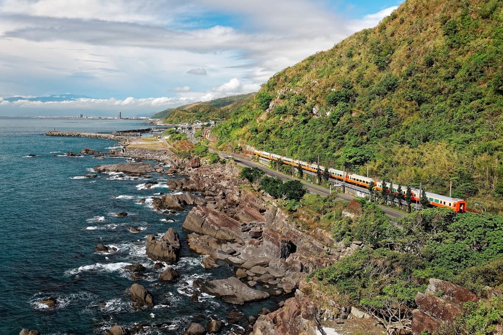
To get to Shaunglianpi Major Wildlife Habitat, board the local express train (TRA) from Taipei to Yilan City.
As Shaunglianpi Major Wildlife Habitat is located in a remote area of Yilan, there are not many direct public transport options available, so hiring a car or scooter is the most convenient and efficient method of transportation. It is an 18 km (11 mi) drive from Yilan City to the Shuanglianpi Major Wildlife Habitat.


