
Scan the QR code and open PeakVisor on your phone
Taipingshan National Forest Recreation Area (太平山國家森林遊樂區) is known for its windswept ocean misty air that drapes the emerald green nature trails with a mystical charm while a wispy sea of clouds circles above the lofty mountain peaks. A total of 19 mountains populates the area of Taipingshan, the highest mountain being Jian Qing Shan (見晴山) at 2,491 metres (8,173 ft), while the most prominent peak is San Xing Shan (三星山) at 2,363 metres (7,753 ft).
Taipingshan National Forest Recreation Area is situated in the Datong Township of Yilan County (宜蘭縣), in northeast Taiwan. Taipingshan is one of the three major forest recreation areas in Taiwan, together with Alishan (阿里山國家森林遊樂區) and Basianshan (八仙山國家森林遊樂區). Taipingshan covers a total land area of 129 sq km (50 sq mi).
Three substantial mountains are found in and around Taipingshan National Forest Recreation Area: Nanhudashan borders the south of Taipingshan, San Xing Shan lies in its centre, while Dabajianshan surrounds the Lanyang River basin in the north and west of the forest area. The northern section of the Central Mountain Range (中央山脈) intersects through Taipingshan.
Besides Jian Qing Shan and San Xing Shan, other mountains of particular interest in the park are Duo Men Shan (多門山), Wang Yang Shan (望洋山), Fang Shan (芳山), Zuoyuhan Shan (佐宇漢山), and Tong Shan (銅山).
The park is surrounded by a number of other protected areas. Taroko National Park (太魯閣國家公園) is located to the south of Taipingshan, while Shei-Pa National Park (雪霸國家公園) is closely situated to the southwest of this area. Dongyanshan National Forest Recreation Area (東眼山森林遊樂區) is in the northwest, and Wufengqi Scenic Area (五峰旗風景區)lies to the northeast. The Pacific Ocean is east of Taipingshan, off the nearby Yilan coast.
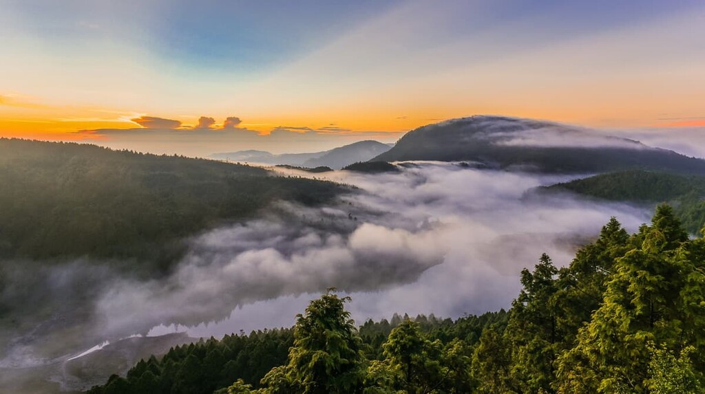
The annual temperature of this misty mountainous area is 13°C (55°F), and the sea wind from the Pacific Ocean causes large amounts of rainfall, which contributes to the heavy humidity levels. Throughout the year, humidity levels do not drop below 85 %, resulting in the mountains being permanently shrouded in mist. It is incredibly cloudy and foggy during the rainy season between October and February.
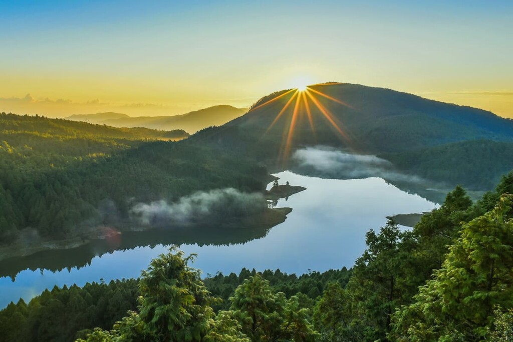
Taipingshan National Forest Recreation Area offers a scenic landscape of verdant forests, thermal hot springs, towering mountain peaks amidst a sea of clouds, waterfalls, and the largest alpine lake in Taiwan. Spring paints the mountain in pastels and while crimson reds dominate in autumn.
Tectonic activity along the Eurasian and Philippine Sea plates created the mountains of the Taipingshan National Forest Recreation Area. This forced the upheaval of lofty peaks along Taiwan’s spine, creating the Central Mountain Range. As Taipingshan sits along the northern edge of the Central Mountain Range, these seismic shifts formed the high-altitude forested area’s towering peaks.
Generous amounts of silt are carried by the fast-flowing waters of the Langyang River, which runs rapidly along the mountains and valleys of Taipingshan. In the depthless stream beds, gravel accumulates, forming alluvial fans that are present on the waterways of the Langyang River.
The rock strata in the park are predominately slate and they mostly date back to the Tertiary. Along the riverbanks, the slate strata has eroded and collapsed in some places from the heavy beating of torrential rains and shock from earthquakes.
Due to the substantial rainfall that this area receives, the excessive moisture weakens the bonds between the bedrock and the overlying soil, resulting in landslides.
The most notorious landslide in the region occurred in 2012 in the aftermath of Typhoon Saola. The area surrounding Taipingshan Villa, which rests on the Miocene epoch Lushan Formation, contains black to grey argillite, shale, slate, and sandstone. As a result of the region’s steep slopes, fragile rock strata, and the subsequent torrential rains, the roads leading into the recreation area saw massive landslides that devastated the region in the wake of the typhoon.
The recreation area contains three distinct elevation zones, each of which supports its own microclimate and ecosystems.
In particular, subtropical ecosystems are found In the low-lying regions located between 200 to 500 metres (656 to 1,640 ft). Some of the most prominent plant species in this area include Acacia confusa, Trema orientalis, Schefflera taiwaniana, large-leafed nanmu, Taiwanese sweet gum, and Ficus microcarpa.
Moving upward in elevation, the next level is characterised by a more temperate climate, particularly between 500 to 1,500 metres (1,640 to 4,921 ft). The vegetation in this zone consists mainly of a mixed forest of broad-leaf and coniferous plants. Bird-lime trees, Formosan michelia, Neolitsea, Taiwan red maple, Taiwan cypress, and Taiwan incense-cedar all grow in this densely forested region.
Higher up the mountain, between 1,500 to 2,400 metres (4,921 to 7,874 ft), cold temperate vegetation dominates. This includes species such as Taiwan hemlock, Taiwan cypress, Taiwan red pine, Taiwan hinoki, and various rhododendrons.
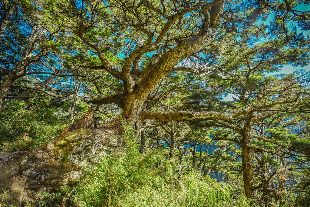
Furthermore, Taiwan cypress is somewhat abundant in the forest. In fact, a towering Taiwan cypress tree measuring 30 metres (98 ft) can be seen at the 14.5 km (9 mi) mark of the Yihuan Route 1, the main forest road in Taipingshan. It boasts a trunk that’s so large that it takes six people to encircle it with their arms. This giant tree is believed to be a staggering 2,500 years old.
Additionally, Taiwan beech is a plant that is a relic of the last major glaciation; thus, it is extraordinary and rare. These ancient trees are slow to bloom as they have a low maturing rate; however, the leaves turn a bright shade of yellow in autumn.
The temperate flowering plant, Digitalis purpurea, adds hues of deep violet in Taipingshan, while the moss-lined forest carpet is characteristic of the nature trails.
The rainy, humid and moist climate of the park attracts a variety of amphibians, lizards, and snakes. There are 13 species of amphibians, with the Japanese tree frog, Rhacophorus moltrechti, and Nidirana adenopleura being the most common amphibians.
A total of 34 species of reptiles are found in the park, including 25 species of snakes and 9 species of lizards. The rarest species are Taiwan pit viper and Diploderma lieu, which are both endemic to Taipingshan, and are found in mid to high elevations.

Birdwatching is a firm favourite of tourists in Taipingshan as the area holds 164 species, with the Swinhoe’s pheasant and Mikado pheasant being the most popular. These large birds are indigenous to Taiwan, and they appear in twilight or at dusk and after the rain.
The mammals found traversing the area of Taipingshan include the Formosan black bear, Formosan macaque, yellow-throated marten, gem-faced civet, and the crab-eating mongoose.
Taipingshan National Forest Recreation Area's woodland areas were long home to the Atayal tribe who lived in the mountains in the region. The scope of Taipingshan was first charted by Japanese indigenous affairs police officers in 1906 as they wandered along the banks of the Langyang River.
Taipingshan was referred to as ‘Mien Nao’ by the Atayal people, which means thick and green forest; however, in 1915, the Japanese changed the name to Taipingshan, which means a state of stability and peace.
Afraid to venture into the guarded woodlands independently, they arranged for the Taiwan police to escort them further through the area to explore the densely forested area. They then noticed the large numbers of cypress trees in the area, which soon led the Japanese to set up a logging industry in Taipingshan.
As a result of this logging industry, Taipingshan has three distinct development zones: the Old Taipingshan Camp, New Taipingshan Camp, and Tayuan Mountain Branch Camp.

The first area that the Japanese developed in Taipingshan was the Old Taipingshan Camp, which was located along the Towan Riverbank in Mount Jia Luo (加羅山). The Old Taipingshan Camp operated during the golden age of the logging industry from 1915 to 1936.
Forestry operations were transferred to the New Taipingshan Camp, set upstream of the Lanyang River Bank and surrounded by Nanhudashan and San Xing Shan. New Taipingshan Camp took over as the logging industry site, as trade flourished from 1937 until 1982 when forestry policies dramatically changed, and the logging industry terminated business in the forest.
Tayuan Mountain Branch Camp was initially established as a private enterprise; however, only after the Japanese defeat in 1945 did the Taiwanese provincial government gain control of this lot and incorporate it back into Taipingshan as a branch camp.
Taipingshan National Forest Recreation Area was established in 1983 after the forestry industry ended operations. The local government developed this area to educate visitors on the history of the logging industry and environmental conversation while simultaneously promoting this picturesque area's ecotourism industry.
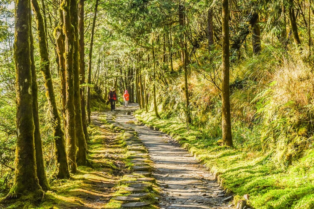
The abundance of forested trails of Taipingshan National Forest Recreation Area are renowned for their fairy tale charm as the misty mountain air hangs like a curtain along the emerald tunnel of prosperous foliage.
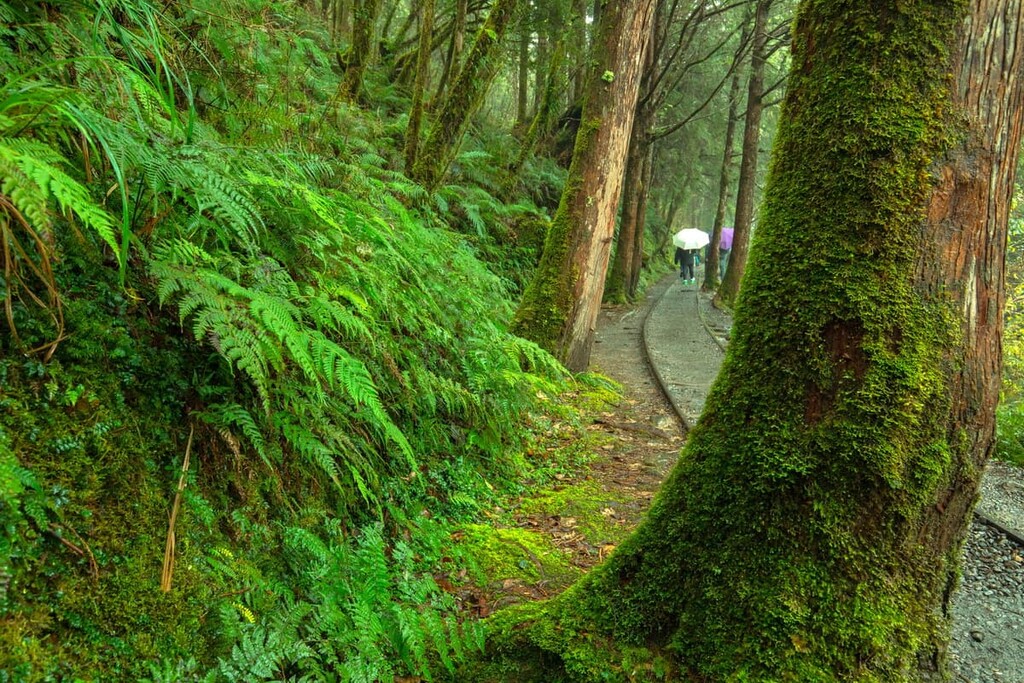
The scenic Jian Qing Historic Trail (見晴懷古步道), follows the old, disused forest railway line along the high mountain elevation at 1,890 metres (6,200 ft).
This trail is just 900 metres (2,953 ft) long, and it offers windy paths that cross a suspension bridge and meander through the tall, opaque forests. In the spring, the gentle rose-coloured flowers of cherry blossoms tinge the trail with beautiful hues of blushing pink.
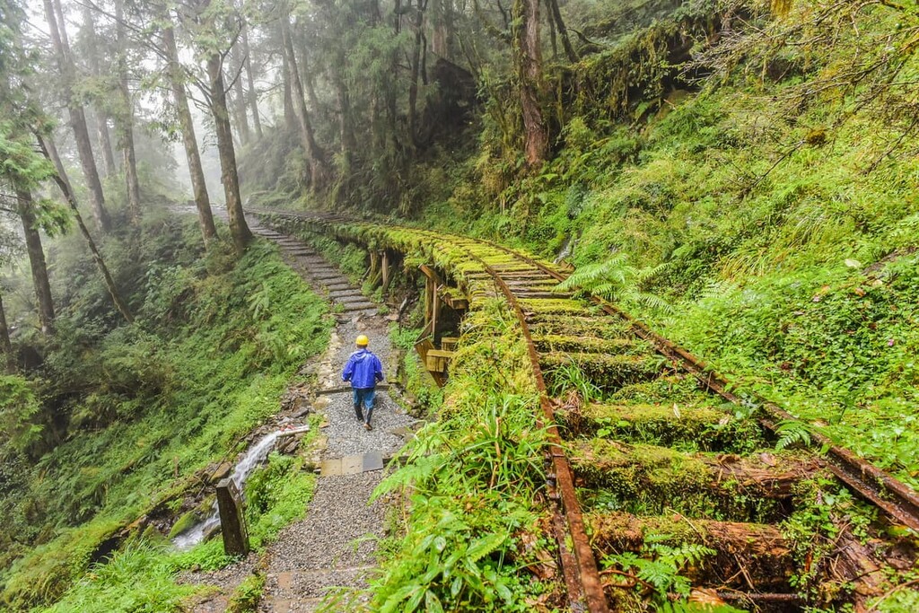
The Jian Qing Historic Trail entrance starts at the 23 km (14 mi) mark of Taipingshan’s forest road, Yihuan Route 1. On a clear, sunny day, the trail offers incredible views of the nearby Lanyang Plain and the behemoth Holy Ridgeline connecting Xueshan and Dabajianshan in Shei-Pa National Park. With the high altitude, a sea of clouds usually hugs the mountain, creating a heavenly scene.
The smooth and flat trail offers a relatively easy stroll along this scenic path. At the same time, hikers are afforded sweeping views of the mountains and insight into historical elements of the past, from the old railway tracks to disused trolleys, axles, and ageing workers' dwellings dotted along the path.
The ethereal Cypress Forest Trail (太平山原始林步道) features a woodland of Taiwan cypress that contort and grow along the path, creating mesmerising displays of nature's art. The forested trail spans a length of 610 metres (2,001 ft) along a high elevation of 2,000 metres (6,562 ft).
At Taipingshan Villa (太平山莊觀景台), where most recreational activities commence, this unchallenging trail loops around the jungly virgin forest. The cheerfully vibrant red Zhenan Temple (鎮安宮) is situated at the beginning of the trail and it offers a fascinating glimpse of a Japanese built Shinto shrine.
The highlight of this trail are the peculiar, warped trees, especially those where younger, healthy trees grow out of trunks of fallen, old trees. This type of tree rebirth is commonly found in the region’s caves and in the vacant spaces between the new sprouts, creating an eerie yet alluring atmosphere.
The Taiwan Hinoki's fragrant woody scent punctuates the fresh mountain air, while the twisting roots of old-growth red cypress created knots and hollows on the fertile forest floor.
Due to the rarity of Taiwan beech, being a relic from the last major glaciation, the 3.8 km (2.4 mi) Taiwan Beech Trail (台灣山毛櫸國家步道) is extraordinary and immensely popular for nature enthusiasts. The course begins near Cueifong Villa, and the first 2.5 km (1.6 mi) of the track is relatively easy as it winds along an old mountain railway. Along the way, hikers will encounter red cypress, Japanese cedar, Taiwan cherry, slate cliffs, moss, and traces of the old railway.
After 3 km (1.9 mi), the trail's incline begins to increase considerably, until, at 3.2 km (2 mi), hikers climb entirely along the mountain ridge. The last section of this trail boasts 9 sq. km (3 sq. mi) of pristine beech forest. Taiwan beech leaves drastically change colour between seasons from verdant green in summer, sunny shades of yellow and deep reds in autumn, and no leaves in winter.
The best month to frequent this trail is autumn due to the Taiwan beech leaves' warm shades.
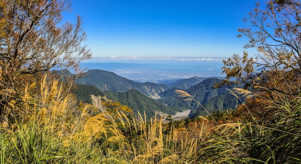
The 1.2 km (0.7 mi) Wang Yang Shan Trail is known as the best spot to witness the peaceful pastel sunrise. The sunrise viewing platform presents a delightful view to watch the welcoming morning sun gently warm the tranquil Nao-ao River Valley, and low-lying Langyang Plain engulfed by mountains. On a sunny day, hikers can spot the offshore Guishan Island (龜山島) in the Pacific Ocean.
From the sunrise viewing platform, hikers can experience another gorgeous view from the lake pavilion overlooking the foggy Cueifong Lake (翠峰湖). As the soft sunlight rays tenderly penetrate layers of clouds, the backdrop of Nanhudshan and Tong Shan make a grand reveal, drastically altering the scenery.
With the high elevation at 2,050 metres (6,726 ft), Wang Yang Shan Trail (望洋山步道) receives excessive rainfall, which allows for a perfect habitat for aquatic creatures like frogs, toads, and diving beetles. The highlights of this trail are the panorama of Yilan Plain and Taiwan cypress, and Taiwan hinoki.
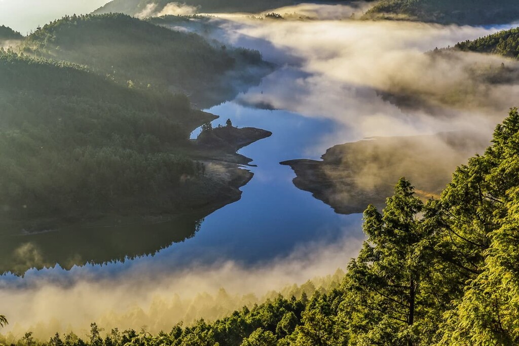
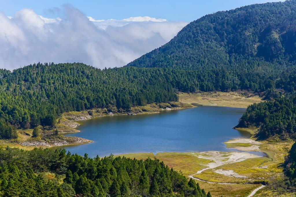
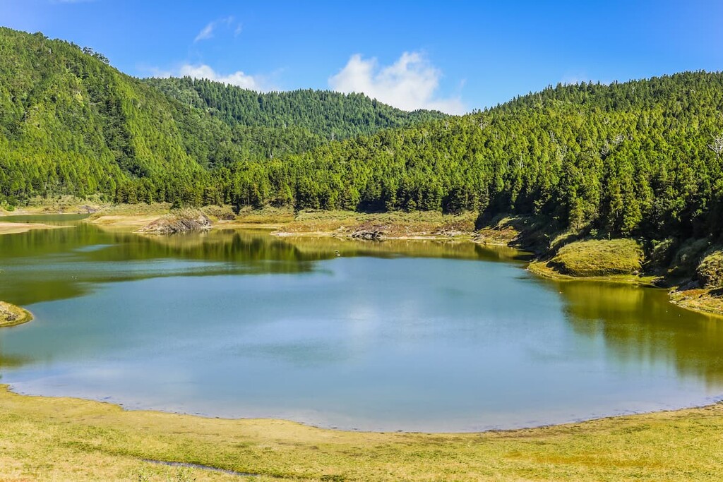
Cueifong, or “emerald peak,” is a stunning high point in Taipingshan that boasts Taiwan’s largest lake—Cueifong Lake—on its slopes.
A beautifully scenic 3.95 km (2.5 mi) hiking trail surrounds Cueifong Lake (翠峰湖), known for its seasonally changing scenery. Leafy greens dominate the view in spring, and hazy mists descend in summer. Red leaves deepen the shades of decor in autumn, while in winter, crisp white snow blankets the area.
Set in the quiet woodland of Taipingshan, part of the trail is carpeted with moss covering rock layers that date to the Ordovician period. The cold and humid mountain air in the region provides the best possible ecosystem for tundra plants to flourish. The last 200 metres (656 ft) of the trail is draped in low-lying peat moss, adding a velvety texture to the path.
Due to the high elevation of the Cueifong Lake Trail (翠峰湖環山步道), the path is relatively infrequently traveled, a fact that helps preserve the pristine ecological elements of this trail.
Situated at an elevation of about 2,000 to 2,180 metres (6562 to 7,152 ft), the Taiwan Hemlock Trail (鐵杉林國家步道) is 2.2 km (1.4 mi) long. The trail passes through terrain that’s dominated by colossal ancient trees, which coat the trail in mysterious cool shadiness as the sun strains to penetrate through the dense foliage.
Behind the virgin cypress forest directly above Taipingshan Villa stands the trailhead. Visitors ascend a flight of 400 stairs through a tunnel of full-bodied burgundy maple trees to reach the trail.
Taiwan hemlock and 100-year-old red cypress lines this moderately challenging trail. The path is situated in the transitional area between conifer forests and broadleaf forests; thus, the trail passes through four forest vegetation zones.
The highest zone contains the mixed forest of Taiwan hemlock and cypress, while the second zone is composed of broadleaf trees, such as Taiwan Rhododendron. Yushania niitakayamensis characterises the third zone, while the fourth and lowest zone is home to herbaceous plants.
At the end of the trail, the viewing platform marks the highest elevation point along a slowly upward gradient, which offers incredible views of both the soft cotton sea of clouds and the glowing amber sunset.
The Maosing Reminiscent Trail (茂興國家步道) offers glimpses of the past through the display of old wooden bridges, defunct railways lines, and ruined cabins as they preserve the old logging industry's historical heritage. This 900-metre (2,953 ft) trail ambles through the moss-covered forest, passing soft humming streams, jagged mountain cliffs following the disused logging trail.
Taiwan cypress, hinoki and Japanese cedar populate the misty forest area, with spritely ferns covering the forest floor, and giant Formosan alders sprouting in sunny areas.
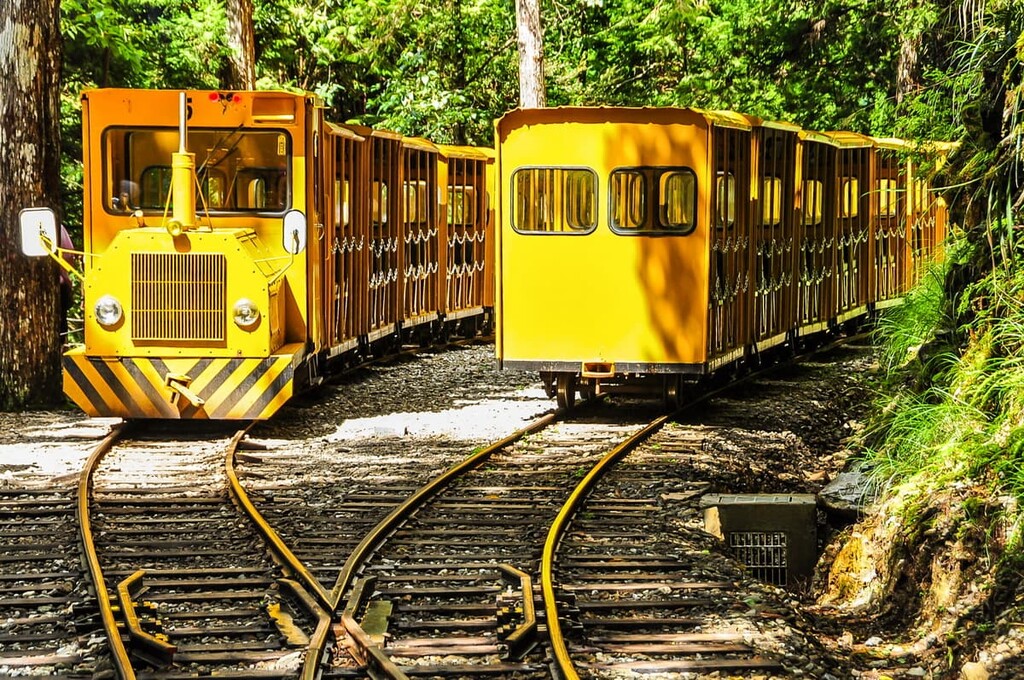
To reach the starting point of this trail at Maosing Platform, one journeys on the Bong Bong Train from Taipingshan Villa. The train's strange name was inspired by the bellowing sound it made as it slowly ascended the slope to Maosing Station.
The Bong Bong Train (蹦蹦車) held an essential role in the logging industry as the primary vessel to transport timber between locations. Taiwan local authorities restored the Maosing Line in 1985, and this 3 km (1.9 mi) route re-opened in 1991 for ecotourism purposes.
Across the Duowong Suspension Bridge from the popular Jiuzhize Hot Spring is the Jiuzhize Nature Trail (鳩之澤自然步道). This 1.1 km (0.7 mi) easy trail offers incredible biodiversity and rich ecology courtesy of the area's temperate climate and heavy rainfall.
Sitting at a shallow elevation of 520 metres (1,706 ft), most of the plants along this trail are broadleaf evergreens of low and medium peaks. Graceful feathery ferns, cushioned ground cover plants, and curved sword-like epiphytes dominate the ground cover.
This area's marshland has been shaped from the presence of surrounding peaks and the Duowong Creek, which has become a habitat for many kinds of birds.
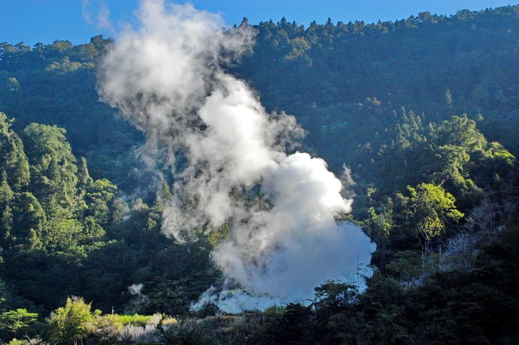
Sometimes referred to as the 'Blue Hot Spring' due to the hot spring's crystal-clear pure water, the Jiuzhize Hot Spring’s (鳩之澤溫泉) water source stems through the mountainside's cracked stone at a severely hot temperature of 284°F (140°C). The water temperature is thus eased from 100 to 108°F (38 to 42°C) for a comfortable bathing experience.
Japanese loggers built the spa pool as a retreat to relax their laborious efforts during the logging industry. The content of the thermal water is weak sodium bicarbonate (NaHCO₃) which adds a slippery layer to the skin.
The hot spring facilities include a spa pool, separate naked bathing pools for men and women, and an outdoor family thermal bathing area. Japanese loggers constructed the spa pool out of massive rock that had fallen down the mountainside by a powerful typhoon.
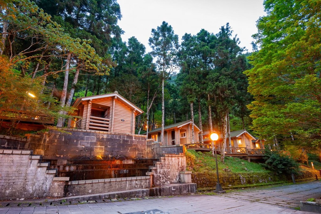
Looking for a place to stay near Taipingshan National Forest Recreation Area? Here are some of the best accommodation options to check out:
The superb three-star Chilan Hotel offers views of the surrounding misty mountains, a sauna and a steam room and includes a complimentary breakfast. Guests can relax on the sun terrace and dine at an on-site restaurant. The rooms are spacious, and the beds are enormous.
The nearby Lutenist Bed & Breakfast affords the best in Taiwan hospitality. Reviews state that the super accommodating owners even offered a dog sofa and cooked a special dog breakfast for a guest’s dog. Each room has a balcony with stunning mountain views. Breakfast is included in the price, and the property has a garden and sun terrace for guests to enjoy.
The highly-rated Juan Teppan-yaki Bed & Breakfast has exceptional reviews on the levels of comfort that the B&B offers. Spacious rooms with floor to ceiling windows allow the Taiwan sun to add gorgeous natural light to the interiors while guests can see magnificent mountain views. A Japanese restaurant is housed in the B&B, with an Asian breakfast served daily.
Urban Oasis Inn houses an outdoor pool, a minibar and allows guests to hire bikes for free. Guests can unwind in the garden and sun terrace, and the vibrant Luodong Night Market is a short walk away.
SUAO Backpackers is conveniently positioned 2 km (1.2 mi) near the beach and is rated for its clean and tidy rooms. The hostel offers free washing machines, and the bright, well-lit interior is very welcoming.

From the major cities of Kaohsiung, Tainan, Chiayi, Taichung, and Hsinchu, head to Taipei on the Taiwan High Speed Rail (HSR) or express train to reach Taipingshan National Forest Recreation Area.
From Taipei Main Station, take the express train to either Yilan City or Luodong. Once at Yilan City or Luodong Train Station, transfer to the Kuo-Kuang bus 1750, which will take you to Taipingshan National Forest Recreation Area.
If coming from Taroko National Park, take the Taroko Trip Bus 310 which shall transport you to Hualien Train Station. From there, take the express train to either Luodong or Yilan City, and then transfer to the Kuo-Kuang bus 1750 to Taipingshan.
Alternatively, you can hire a car or scooter and drive from Taipei. The journey takes just over 2 hours over a distance of 118 km (73 mi). If you want to rent a car or scooter from Yilan City or Luodong, the journey is 63 km (39 mi) and 60 km (37 mi), respectively.


