
Scan the QR code and open PeakVisor on your phone
Réserve faunique de Rimouski (Rimouski Wildlife Reserve) is a large protected area located in the southeastern part of the Canadian province of Quebec, just to the west of the Gaspé Peninsula. There are 8 named peaks in the wildlife reserve, the highest and most prominent of which is Montagne du Lac Dumont (579 m/1,900 ft).
Réserve faunique de Rimouski (Rimouski Wildlife Reserve) is a provincially managed protected area in the Canadian province of Quebec.
The reserve encompasses 729 sq. km (281 sq. mi) of terrain in the Rimouski-Neigette Regional County Municipality (MRC) of the Bas-Saint-Laurent region of southeastern Quebec. It is situated just to the west of the Gaspé Peninsula proper to the south of the city of Rimouski and to the north of Restigouche County in New Brunswick.
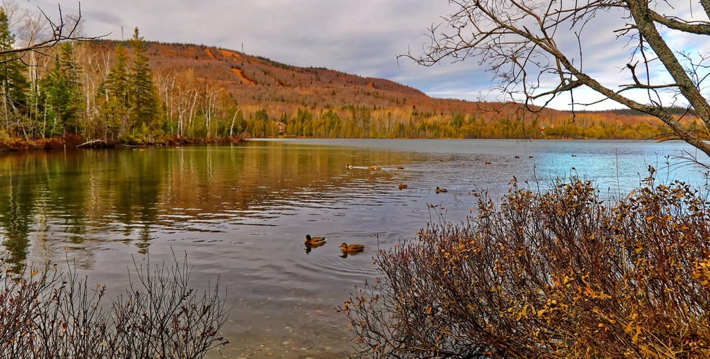
Within Rimouski Wildlife Reserve, the terrain is relatively low-lying and there are few major peaks. Much of the terrain in the reserve is dominated by rolling hills, lakes, and rivers.
Réserve faunique de Rimouski borders a number of other protected areas in Quebec. This includes ZEC Owen to the west, ZEC du Bas-Saint-Laurent to the east, and the réserve écologique Charles-B.-Banville to the north.
Like most other wildlife reserves in Quebec, réserve faunique de Rimouski is managed by Sépaq, or the Société des établissements de plein air du Québec (Quebec Outdoor Establishments Company). Sépaq maintains most of the trails, camping areas, and cabins in the wildlife reserve and for many of the protected areas in the region.
The peaks within réserve faunique de Rimouski are part of the Canadian Appalachians, which is a subrange of the greater Appalachian Mountains.
The Canadian Appalachians run from southern Quebec, New Brunswick, and Nova Scotia north to the tip of Newfoundland. They are an extension of the Appalachians, which start in the US state of Alabama and continue into eastern Canada.
A section of the mountains of réserve faunique de Rimouski, particularly in the northern part of the reserve, may also be classified as being part of the Notre Dame Mountains. The Notre Dame Mountains are a subrange of the Canadian Appalachians that covers much of eastern and southern Quebec to the south of the Saint Lawrence River.
Either way, the peaks in the area formed in a similar way as the rest of the Canadian Appalachians. In particular, the Taconic orogeny, a major mountain-building event that helped to create many of the mountains in the northeastern US and eastern Canada, also helped to build the peaks that are located in Rimouski Wildlife Reserve.
For the most part, the rocks in the Notre Dame Mountains are sedimentary in origin, though there are also pockets of metamorphic rocks and some igneous intrusions.
The vast majority of the region also experienced extensive glaciation during the Pleistocene. These glaciers helped to carve out the many valleys and lakes in southeastern Quebec and they rounded over the tops of many of the region’s mountains, which is why jagged peaks are hard to come by in this part of the world.
Some of the most notable high points in réserve faunique de Rimouski include Montagne du Lac Dumont, Montagne à Dubé, Sommet Bernard-Voyer, Montagne du Lac Perdu, and Montagnes du Lac Charlotte.
As is the case with most of the rest of southeastern Quebec, réserve faunique de Rimouski is heavily forested. The forests in the area are a mix of spruce, balsam fir, white birch, and maple, though you may find other species depending on the specific aspect and elevation of a particular area.
As far as animals go, there are many mammals that call the region home. This includes moose, black bears, beavers, white-tailed deer, snowshoe hares, and coyotes. Some of the many birds that live in the reserve include spruce grouse, ruffed grouse, ospreys, and bald eagles.
Réserve faunique de Rimouski is home to over 47 different lakes and countless rivers and streams. Within these bodies of water, you can find many fish species such as splake, lake trout, and speckled trout.
The land that is now part of réserve faunique de Rimouski has been home to humans for thousands of years. There are a number of First Nations with ancestral claims to this land, including the Wəlastəkwewiyik (Maliseet) First Nations of the Wabanaki Confederacy.
French settlers were among the first people of European descent to try to colonize the area of the Bas-Saint-Laurent and the Gaspé Peninsula. The first French expedition to make landfall in the region was led by Jacques Cartier in 1534, but they landed well to the east of the current reserve on the tip of the Gaspé Peninsula.
Due to the remoteness of the region, the area that is now Rimouski Wildlife Reserve wasn’t heavily settled during the seventeenth through eighteenth centuries. In the late nineteenth century (around 1880), the land in the current reserve was actually claimed by a US-based organization called the Margaret Brooks Fish and Game Club, which was founded by Colonel Winz.
By 1939, the government of Quebec had decided to take possession of the club’s 394 sq. km (152 sq. mi) territory.
The government then distributed the lands in the area among five private fish and game clubs in Quebec called Rimouski, Labbé, Des Eaux Mortes, Taché, and Caribou. However, these clubs were very exclusive, so most people had no access to the land for hunting or recreation.
In 1952, an area of approximately 54 sq. km (21 sq. mi) was set aside as a wildlife reserve in the region. This area was formally designated as the réserve de chasse et pêche Horton.
During the 1960s, the existing reserve was expanded to include an area of 700 sq. km (270 sq. mi). The government of Premier Jean Lesage also withdrew exclusive hunting and fishing rights to the region from the five private game reserves that had received land in the 1930s. The subsequent reserve was then renamed Réserve Rimouski.
In 1979, the reserve expanded to its current size of 729 sq. km (281 sq. mi) and it gained full status as a wildlife reserve. Management of the area was later transferred to Sépaq, which administers the reserve to this day.
Although it is quite a large protected area, there are relatively few maintained hiking trails in réserve faunique de Rimouski due to the fact that hunting, fishing, and paddling are much more popular activities in the region.
The only trail of note in the wildlife reserve is the Explorateur Trail (Sentier de L’Explorateur), which is 4 km (2.5 mi) long. This loop is family-friendly and it takes most people about 2 hours to complete. It is an educational trail that takes you through dense forests and leads to the top of Sommet Bernard-Voyer, a peak named after celebrated French Canadian mountaineer and Rimouski local Bernard Voyer.
According to Sépaq, you can pick up a paper map of this trial at the Lac Rimouski Registration Centre. However, the trail itself is well-signposted and it features informational boards that recount Bernard Voyer’s main expeditions.
There may not be many maintained hiking trails in réserve faunique de Rimouski, but there are plenty of other outdoor activities that you can enjoy in the park, instead.
Hunting and fishing are by far some of the most popular activities in the wildlife reserve. To fish in the reserve, you’ll need to pay for a right of access day pass at the reserve’s registration center or online. Note that there are limits in place for how many fish you can catch and keep each day, so be sure to consult the reserve’s regulations before your adventure.
As far as hunting goes, the reserve offers small game, moose, and black bear hunting during the proper seasons. Small game hunting usually takes place during the late fall (October) while black bear hunting normally occurs in late spring or early summer. For moose hunting, the season is normally between September and October.
The annual quotas for moose and black bears are regulated by the province. You can only get a permit for moose hunting via a lottery draw and anyone interested in bear hunting should contact Sépaq directly. For small game hunting, you will need to buy a daily right of access pass online for the appropriate zone. Always be sure to double-check any local regulations before going hunting in the reserve.
If hunting and fishing aren’t quite your style, there are other ways to adventure in the reserve.
In particular, nearly all of the lakes in the reserve are suitable for flatwater kayaking. Lac Rimouski and Grand Lac Kedgwick are especially popular destinations for kayaking in the reserve. If you don’t have a kayak, you can rent a boat and life jackets from the reserve’s registration center for a fee.
Any trip to réserve faunique de Rimouski is sure to be an adventure to remember. Here are a few things to keep in mind before your next trip to the region.
As of the time of writing, there are no entrance fees for visitors to réserve faunique de Rimouski.
Sépaq does charge daily right of access fees for visitors who want to fish or hunt in the reserve, however, you generally don’t need to pay a fee just to enter the park. For the latest information about park fees, check out Sépaq’s official website for the Rimouski Wildlife Reserve.
Réserve faunique de Rimouski is relatively easy to get to, despite its remote location. The only reliable way to get to the wildlife reserve, however, is by car, so you will need to have a vehicle to get to the region.
You can get to the main registration center in réserve faunique de Rimouski from the city of Rimouski in just over an hour. From the city of Rimouski, you simply need to take QC-232 O until you reach route de la Réserve de Rimouski. From here, you can continue into the park until you find your destination.
There is only one registration center in the wildlife reserve that’s regularly open to visitors and that offers both equipment rentals and fishing access permits.
This registration center is called the Lac Rimouski Registration Centre and it’s located on route de la réserve de Rimouski on the southern side of Lac Rimouski. The registration center is located about 45 km (28 mi) inside the reserve at the following GPS coordinates: 48.017715369347805, -68.2134675970608.
As a general rule, the registration center is open from mid-May to mid-November between about 8:00 am and 8:00 pm, though operating hours can vary. If you have specific questions about the registration center’s hours, you can call them directly at +1 (581) 805-8006.
Interested in spending the night in réserve faunique de Rimouski? Here’s a quick look at the main camping and accommodation options in the wildlife reserve.
There are only a handful of camping areas in the Rimouski Wildlife Reserve. They are primarily located along the shores of La Rimouski, about 40 km (25 mi) away on a gravel road from the Lac Rimouski Registration Centre.
At this camping area, you can find 2 campsites that have water, electric, and sewer hook-ups as well as 4 campsites with a washroom facility nearby. These campsites are reservable starting around the end of April each year and it’s highly recommended that you reserve your site well in advance on the Sépaq website.
For those of us who enjoy a hint of luxury when in the wilderness, réserve faunique de Rimouski offers a plethora of different cabin options to choose from.
Rimouski Wildlife Reserve features 28 classic cabins that can sleep 2 to 8 people each. There are also 4 so-called Horizon cabins that can sleep 6 people each and 5 Modik cabins that can sleep 4 people each.
You can reserve the classic and Horizon cabins online, but the Modik cabins are only offered as part of Sépaq’s “fishing package with accommodations.” Keep in mind that cabin reservations for the summer can book up quickly, so be sure to reserve your spot well in advance of your trip.
Looking for a place to stay during your next trip to réserve faunique de Rimouski? Here are some of the best cities and towns to check out in the surrounding area.
The city of Rimouski is both the county seat of the Rimouski-Neigette MRC and one of the main gateways to the Gaspé Peninsula. Rimouski is situated just to the north of its namesake réserve faunique de Rimouski. It takes about 1 hour to get from the city to the reserve’s Lac Rimouski registration center by car, but you can get to the reserve’s boundaries in about half an hour from Rimouski.
Rimouski is worth a visit in its own right as it is a seaside city with great views of the Saint Lawrence River. The city’s biggest industries are healthcare, shipping, transportation, and tourism.
Each year, Rimouski hosts a number of festivals, such as the Festi Jazz International. It is also home to the Rimouski Océanic, a Quebec Major Junior Hockey League team whose home games are well-attended.
You can get to Rimouski by car, bus, or train. There’s also a ferry that runs between Rimouski and Forestville, Quebec if you want to quickly cross the Saint Lawrence. Alternatively, you can fly into the Mont-Joli Airport (YYY) airport from elsewhere in Quebec, but you’ll probably find that it’s easier to fly into Quebec City and then make your way to Rimouski by car.
Témiscouata-sur-le-Lac is a community with approximately 5,000 residents located to the southwest of réserve faunique de Rimouski. As the town’s name suggests, it is located on a lake, namely Lac Témiscouata.
The municipality was actually formed from the merger of two smaller cities, Notre-Dame-du-Lac and Cabano. These former cities continue to act as separate “sectors” of the municipality alongside a number of other surrounding communities such as Route-du-Sault and Rivière-Creuse.
Although Témiscouata-sur-le-Lac is a relatively small municipality when compared to Rimouski or Quebec City, it is a tourist destination in the region. The community is home to Fort Ingall, a reconstructed nineteenth-century British fort that now houses a museum. Lac Témiscouata itself is also a very popular place for watersports and outdoor recreation.
Transportation to Témiscouata-sur-le-Lac is primarily via road. To get to the town, you can drive either about 1.5 hours from Rimouski to the northeast, around 3 hours from Quebec City to the southwest, or 40 minutes from Edmunston in New Brunswick to the south.
Quebec City is the capital and second-largest city by population in the province of Quebec. It is located to the southwest of réserve faunique de Rimouski along the Saint Lawrence River.
The city has a population of around 530,000 residents and it is one of the oldest European-established communities still in existence in North America. The land that is now Quebec City has been home to First Nations for thousands of years, though the first French settlement in the region dates to 1608 when it was founded by Samuel de Champlain.
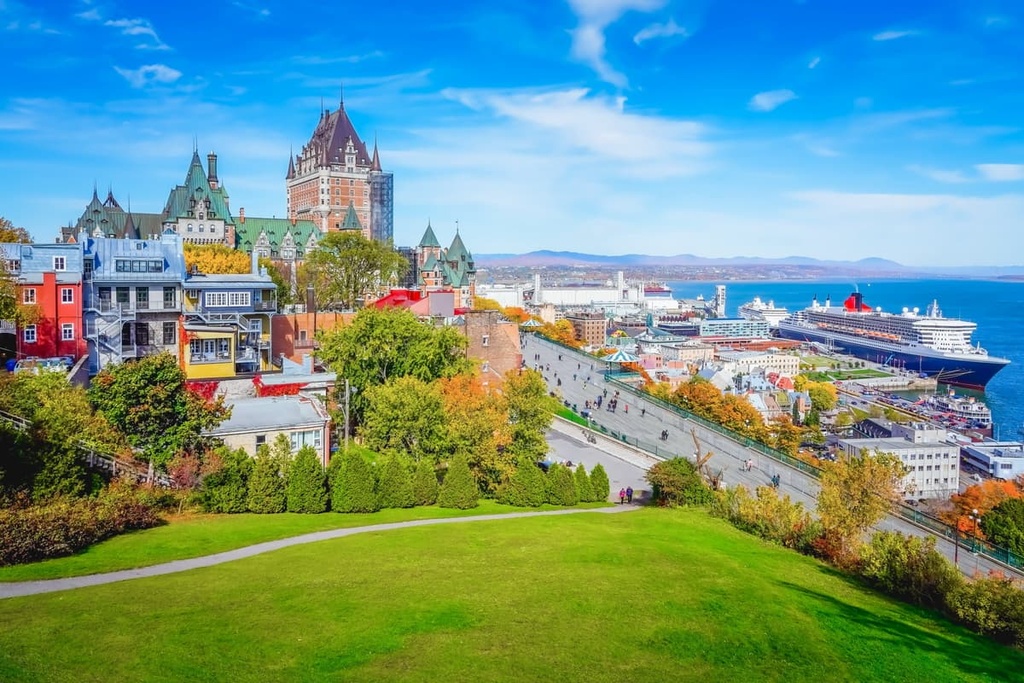
Nowadays, Quebec City is a very popular tourist destination, in part because of its scenic buildings and great restaurants. The city’s old town (Vieux-Québec) is home to the only remaining fortified city walls in North America to the north of Mexico and it is a designated UNESCO World Heritage Site.
You can get to Quebec City by road, rail, or bus from Montreal or from elsewhere in eastern Canada. Quebec City is also home to the province’s second-busiest airport, so you can fly directly to it from across Canada and from select international destinations.


