
Scan the QR code and open PeakVisor on your phone
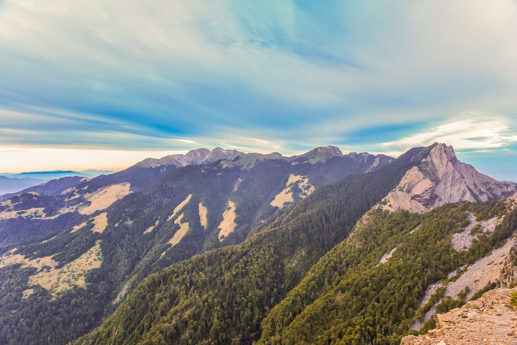
Taiwan Sakura Salmon Ecological Reserve (台灣櫻花鈎吻鮭生態保護區) is a protected area located in the the southeastern part of Shei-Pa National Park (雪霸國家公園) in central Taiwan. The area contains a total of 21 named mountains, with Xueshan Main Peak (雪山主峰) being the highest and most prominent mountain at 3,886 metres (12,749 ft) in elevation.
Taiwan Sakura Salmon Ecological Reserve covers 7,095 ha (17,532 ac) of land in the Heping District (和平區) of Taichung City (臺中市) in central Taiwan.
The reserve contains two of the main attractions of Shei-Pa National Park: the commanding and ever-popular Xueshan Main Peak, and the natural habitat of the critically endangered Taiwan sakura salmon. The presence of sakura salmon is found in the Qijiawan River (七家灣溪), which runs north to south and is situated just south of Taoshan (桃山).
Xueshan translates as “Snow Mountain.” This name is quite appropriate as the peak of Xueshan is covered by snow year-round. Xueshan Main Peak is second only to Yushan (玉山), Taiwan’s highest peak, in elevation, making it the second-highest mountain in Taiwan.
Furthermore, Xueshan is actually a group of mountains consisting of Xueshan Main Peak (雪山主峰), Xueshan East Peak (雪山東峰), Xueshan West Peak (雪山西峰), Xueshan North Peak (雪山北峰), Xueshan South Peak (雪山南峰), and Xueshan Southwest Peak (雪山西南峰). Xueshan Main Peak and Xueshan East Peak are the only two peaks that fall within the vicinity of Taiwan Sakura Salmon Ecological Reserve.
The other prominent mountains in Taiwan Sakura Salmon Ecological Reserve are Taoshan (桃山), Pintianshan (品田山), Chryou Shan (池有山), Mutelaba Shan (穆特勒布山), Kalaye Shan (喀拉業山), and Kailantekun Shan (凱蘭特崑山).
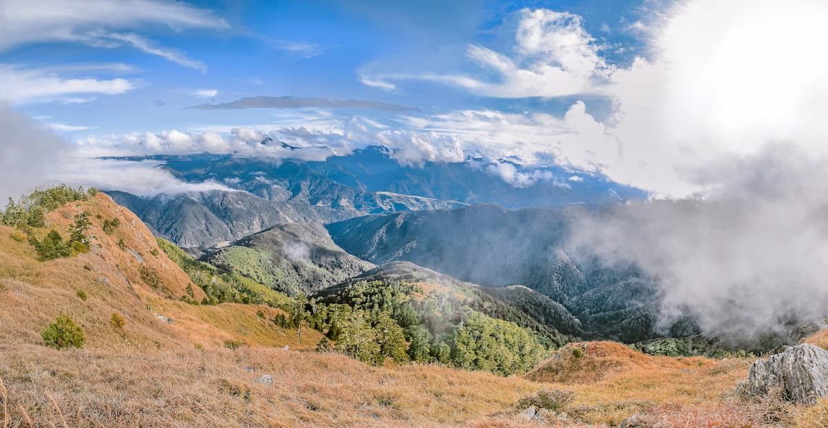
While the location of Taiwan Sakura Salmon Ecological Reserve is 100 km (160 mi) north of the Tropic of Cancer, the climate of the region is quite varied. The microclimates in the area range from warm temperate to alpine. At the same time, the area experiences an annual rainfall between 1,500 to 3,000 mm (59 to 118 in), which increases the humidity and misty cloud cover in the region.
Places of interest that lie near the Taiwan Sakura Salmon Ecological Reserve are Basianshan National Forest Recreation Area (八仙山國家森林遊樂區) in the south and Taroko National Park (太魯閣國家公園) to the east. The revered mountain of Dabajianshan (大霸尖山) lies to the north, while the Jiaren Mountain and Madara River Regional Ecological Reserve (佳仁山、馬達拉溪區域生態保護區) is located to the west.
Xueshan Range (雪山山脈), one of the major mountain ranges in Taiwan, contains 54 peaks over 3,000 metres (9,842 ft). Furthermore, 19 of its peaks make the list of the top 100 mountains in Taiwan for hiking and adventure. It spans from central Taiwan to the northeast coastal area of New Taipei City (新北市). Within the borders of Taiwan Sakura Salmon Ecological Reserve, 6 of the 12 mountains fall within Taiwan’s top 100 peaks.
Sandstone, shale, and slate of the Eocene and Miocene epochs primarily comprise the rock strata belonging to the Xueshan Range. In addition, high fold strata feature on some of the hills in the Xueshan Range, the most prominent being the box fold on Pintianshan.
Facets of the last glacial maximum are exposed on the Xueshan peaks. Just below the summit on Xueshan Main Peak is a glacial cirque in the form of a hollowed-out inverted bowl that is the largest glacial cirque in Taiwan. Thus, it was granted the name 'Glacial Cirque Number 1'.
Although Xueshan North Peak does not form part of the Taiwan Sakura Salmon Ecological Reserve, 'Glacial Cirque Number 2' is a unique U-shaped hollow present on the lower slopes.
The diversity of vegetation in Taiwan Sakura Salmon Ecological Reserve is affected by the different microclimates and forest zones that stretch from the valleys to the highest point of Xueshan Main Peak.
The microclimates in the area range from warm temperate to alpine, thus the plant life changes as the elevation increases.
From 500 to 1,500 metres (1,640 to 4,921 ft) of the mountain's lower reaches, the Machilus-Castanopsis zone features a mixed broadleaf forest of camphor and chestnut trees. Following this, from 1,500 to 2,500 metres (4,921 to 8,202 ft), lies the Quercus zone where the dominant tree species are Taiwan red cypress and Chinese oak.
The Tsuga-Picea zone, which contains mostly Taiwan spruce and Chinese hemlock, sits between 2,500 to 3,100 metres (8,202 to 10,171 ft), followed by the cold-temperate Abies zone 3,100 to 3,600 metres (10,171 to 11,811 ft). Yushan juniper and Taiwan fir comprise the vegetation of this sub-alpine coniferous forest.
Finally, at 3,600 metres (11,811 ft) and beyond lies the alpine zone with plant life belonging to the subarctic microclimate. Taiwan sassafras thrives in this area, sparse in plant life, as the whippy winds and snow-soaked ground cover create a suitable environment for the soil to nurture growth of these hearty plants.
One of the iconic ecological features of this reserve is sakura salmon, also known as Oncorhynchus masou formosanus, Formosan landlocked salmon, and cherry salmon. Interestingly, sakura salmon are a relic from the last glacial maximum that have adapted to the changing environment over millennia.
Sakura salmon migrate to the fresh ocean water until maturation, at which point they return inland to the rivers and lakes to spawn. Over the millennia, an ever-changing climate has altered the landscape; thus, the rivers that once led to the oceans have become landlocked. Sakura salmon cannot escape to the sea and have adapted to living in a landlocked environment.
However, despite the fact that salmon thrive in colder waters, the sakura salmon are the only salmon in the world that live near the tropics. Their adaptive nature makes these species a truly fantastic natural phenomenon. But, these remarkable creatures are endangered; thus, the Taiwan Sakura Salmon Ecological Reserve was established to protect these at-risk fish.
Additionally, the diversity of plant life in the region thus creates a range of different habitats for wildlife in the area. In fact, at least 26 species in the reserve are endemic to Taiwan.
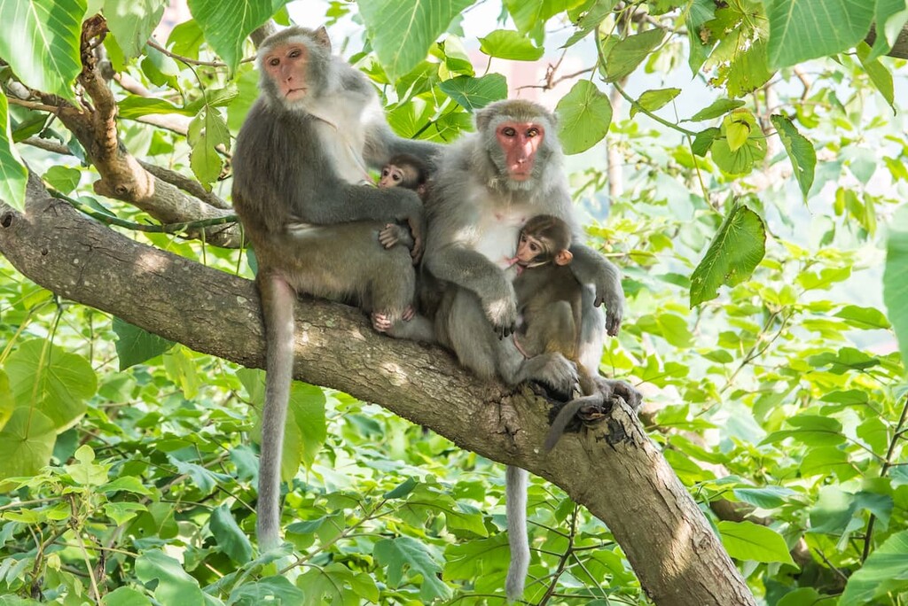
There are 58 species of mammals in the reserve, such as the Formosan black bear and Formosan macaque. The Mikado pheasant and Swinhoe's pheasant account for 2 of the 154 species of birds.
Taiwan Sakura salmon is 1 of the 17 species of fish in the reserve, while 39 kinds of reptiles and 16 types of amphibians inhabit the area.
The Taiwan Sakura Salmon Ecological Reserve region was once an area inhabited by the mountain living Atayal and Sisiyat tribes. The Sisiyat people traditionally lived in communities at elevations between 500 to 1,000 metres (1,640 to 3,281 ft), while the Atayal people traditionally lived further afield at elevations of 1,000 to 1,500 metres (3,281 to 4,921 ft).
Both these tribes forged pathways in the mountains to hunt and fish for food. The tribes living close to the Qijiawan River would catch Taiwan Sakura salmon, which over time, substantially diminished the population of the fish species. In July 1984, the Cultural Heritage Preservation Law listed the Taiwan sakura salmon as a precious natural property, and thus preservation measures have been created to protect these near-extinct species.
During the Japanese Occupation Era, the Atayal and Sisiyat people were forced to live on a mountain road under Japanese surveillance to access the mountain forests. A huge logging industry was created by chopping the giant camphor trees used to produce camphor oil.
While the Indigenous peoples of the region are no longer allowed to live within the borders of Taiwan Sakura Salmon Ecological Reserve or Shei-Pa National Park, their ancient mountain paths remain popular mountain trails for hikers.
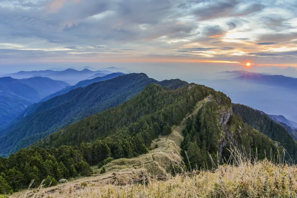
Most of the trails in Taiwan Sakura Salmon Ecological Reserve encircle the mighty Xueshan. As Xueshan is the second-highest mountain in Taiwan, the treks in the reserve area are pretty popular due to the high demand of people wishing to summit the iconic snow-capped mountain.
The East Xue Trail summits the two mountains of Xueshan East Peak and Xueshan Main Peak over a three-day trek. The entire journey spans 22 km (14 miles). The highlights of this trail are the mysterious beauty of the Black Forest featuring a woodland of Taiwan fir, the staggering panoramic prospect on Xueshan Main Peak, and the intriguing glacial footprint of ‘Glacial Cirque Number 1’.
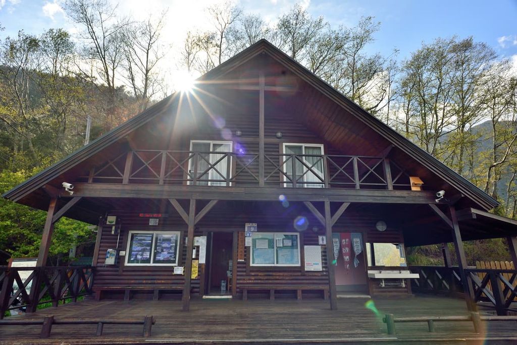
Hikers begin the trek at Wuling Recreation Area, where they start to ascend the mountain of Xueshan East Peak. After the 2 km (1.2 mi) mark, the climb intensifies once hikers pass Qika Hut, which leads to the tiresome, challenging and near-vertical incline known as the ‘crying slope.’ Hikers then reach the summit of Xueshan East Peak, where the Holy Ridge, a mountain passage that connects Xueshan to Dabajianshan, is clearly distinguishable.
Hikers then continue for 2 km (1.2 mi) through plains of Yushan cane to the Sanliujiu Hut (369 Hut), the overnight accommodation, before venturing to Xueshan Main Peak in the early hours of the morning. Hikers then pass the shaded and dense Black Forest featuring clusters of towering Taiwan fir with a coat of mist draped low to the forest floor which features loose rock and rugged terrain. Thus, hikers should practice caution, especially when trekking in the dark.
Once through the Black Forest, hikers encounter Glacial Cirque Number 1, where traces of snow may be present. The path leading up from here becomes challenging as the incline steepens. Along the way, the warped and twisted Yushan Sabina with its eerily sharp and bendy branches looks like a witch’s clawed hand.
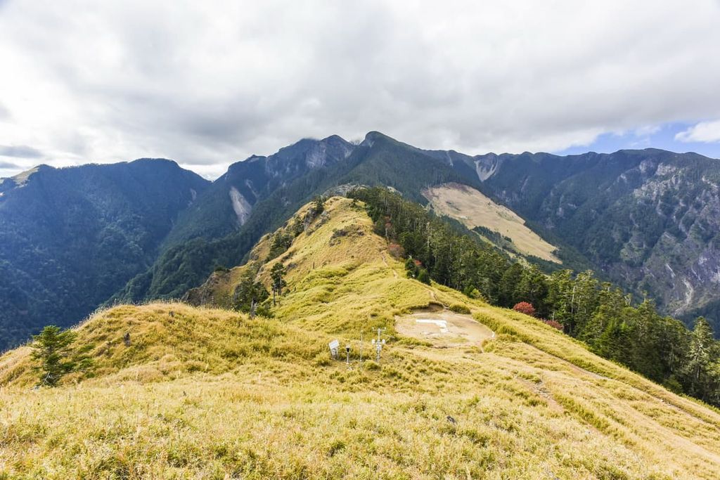
The summit of Xueshan Main Peak offers sublime views of the surrounding mountains. Zhijiayang Shan (志佳陽山), Dajianshan (大劍山), Da Xue Shan (大雪山), and Xiao Xue Shan (小雪山) can be viewed in the west. In the north, hikers can note the summits of Xueshan North Peak, Dabajianshan, Pintianshan, and Mutelaba Shan. Shenmazhen Shan (審馬陣山) and Nanhu Dashan (南湖大山) of Taroko National Park can be observed in the east.
Hikers descend the mountain to Sanliujiu Hut to rest for the night before venturing down the hill towards Wuling Recreation Area.
The four mountains of Pintianshan, Chryou Shan, Taoshan and Kalaye Shan feature along this 10 km (6.2 mi) westward mountain trail. The trail highlights include the prime view of the Holy Ridge, the constant dramatic backdrop of mountains along the route, and the scenic changes in vegetation from hemlock forests to alpine grasslands.
Hikers begin the three-day trek from Wuling Recreation Area, where they ascend Chryou Shan, reaching Xinda Hut, the resting place for the night. In the morning, hikers then head west towards the grassy meadows of Pintianshan.
Hikers will then climb steeper terrain below the summit of Pintianshan by scaling the infamous ‘U shaped’ cliff to reach the summit. Rope assists are used to summit the craggy cliffs, which rise sharply and dip steeply.
On the summit of Pintianshan, hikers have a spectacular view of the Holy Ridge right in front of them and an ocean of pointed peaks encircling the landscape. Xueshan Main Peak, Dabajianshan, Xiaobajianshan (小霸尖山), Zhongyang Jianshan (中央尖山) and Mutelaba Shan are easily distinguishable.

Hikers then head eastwards to Chryou Shan, retracing their path back to Xinda Hut and then continuing towards the summit. The climb up Chryou Shan is more straightforward and less taxing than scaling the enormous cliffs of Pintianshan. The grassy summit features rhododendron flowers that add to the beauty of the prospects of Xueshan, Dabajianshan, and Pintianshan.
Descending Chryou Shan is an ominous task, as the terrain is littered with lumpy tree roots, wobbly mounds, and slippery, rocky surfaces.
Hikers then set forth towards Taoshan Hut, between Chryou Shan and Taoshan, to rest before embarking on the final day of their trek to summit the last two remaining mountains. Taoshan is the next mountain to climb, which has a similarly exposed terrain like Chryou Shan, except this time hikers are ascending the mountain.
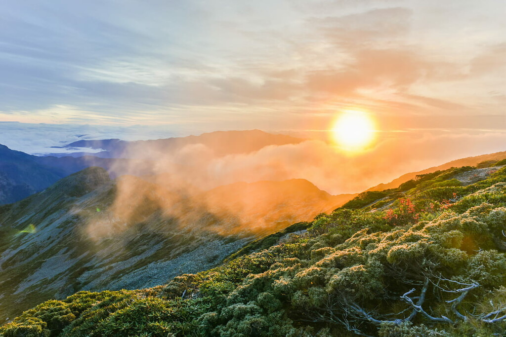
The warm, promising soft ray of the sunrise gently illuminates the sky as hikers stand on the summit of Taoshan, witnessing the vast display of tufty clouds, mountain forests, and the jagged peaks. Hikers then head towards the final fourth peak, Kalaye Shan, passing through an alpine forest of Taiwan white pine and dense clusters of Yushan cane.
Nanhu Dashan and Zhongyang Jianshan of Taroko National Park are in plain sight from the summit of Kalaye Shan. Hikers then descend the mountain, heading back to Wuling Recreation Area.
In the past, the Zhijiayang Shan Hiking Trail was used as the sole path to summit Xueshan. While the East Xue Trail has become the prime route to reach Xueshan, the Zhijiayang Shan Hiking Trail remains one of the most accessible passages to climb to this mammoth peak.
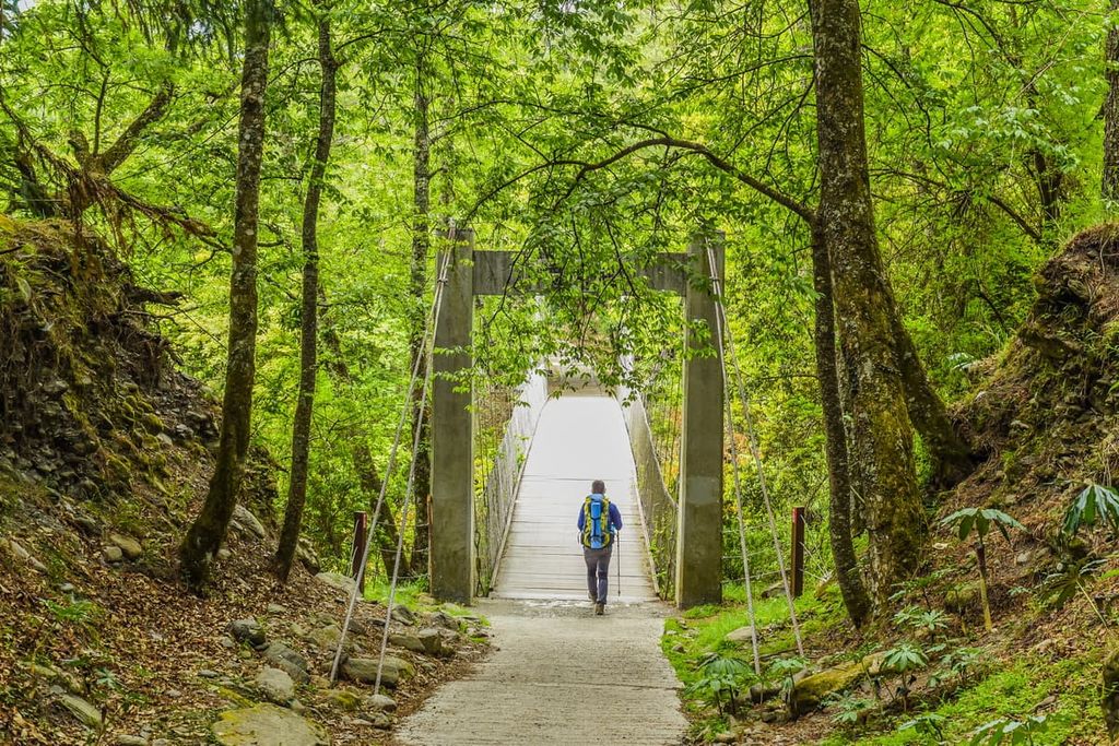
The trail starts at the Four Seasons Lanxi Suspension Bridge, which traverses a valley that leads parallel to the stream. The trail rises gently to an iron bridge fixed to the mountain ledge, offering sweeping views of the lush forestland in the valley below.
Hikers are then met with a steep ascent after the 3 km (1.8 mi) mark, climbing up rock walls and journeying up sharp hills. Hikers set up camp at Piaodon Hut for an overnight rest before heading off early the following morning to summit Zhijiayang Shan.
A dense pine forest is situated at the base of the mountain, and hikers pass Piaodon Pool, the vast lake of water that mirrors the verdant slopes of Zhijiayang Shan. Before reaching the summit, a thicket of Yushan cane is encountered before enjoying the views of the snow-capped mountains of Xueshan, Dajian Shan, and Zhongyang Jianshan.
Hikers can either head towards Xueshan Main Peak or return to the trailhead at Four Seasons Lanxi Suspension Bridge.
Starting from Wuling Recreation Area, this 4.3 km (2.6 mi) trail features a paved footpath shaded with pine trees leading to the 50-metre (164 ft) shower of Taoshan Waterfall.
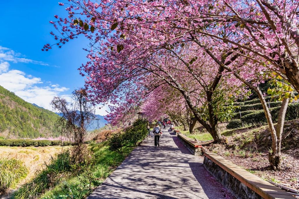
The trail is gorgeous in autumn as the crimson leaves embellish the forest in golden and warm shades. In spring, the journey is sprinkled with the blooming of cherry blossoms. Along the path, hikers cross Wuling Suspension Bridge with the Qijiawan River flowing underneath where sakura salmon thrive.
The Taoshan Waterfall Trail is renowned for its scenic prospects as the mountains of Taoshan and Xueshan are visible from clearings in the path. Most of the way is shaded with an evergreen forest of Taiwan white pine, Formosan juniper, Taiwan alder, and Taiwan cedar.
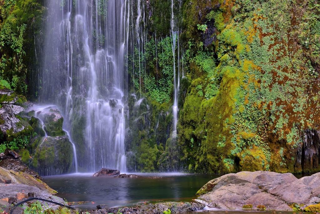
Taoshan Waterfall is commonly referred to as Yansheng Waterfall, which means the sound of mist, as the 50-metre (164 ft) cascading sheet of water crashes into the pool bed, vaporising the valley in a refreshing drizzle. The water flow is especially tumultuous in spring and summer during the rainy season, where the spectacle of sound and steam is most powerful.
While the Taiwan Sakura Salmon Ecological Reserve is situated in Taichung, Yilan (宜蘭市)is the closest city. In addition, the area of Wuling Farm is a prime spot to stay due to its proximity to the trailheads and its nearby access to Taroko National Park and Basianshan National Forest Recreation Area.
As Yilan is only a 64 km (40 mi) journey from Taipei (臺北市), it offers an escape from the frantic, fast-paced life of the capital with its laid-back and unhurried lifestyle. One of the advantages of Yilan is its proximity to splendid environmental scenic areas and the abundance of nature activities, such as hot and cold springs.
The three-layered Wufengqi Waterfall is the centrepiece of Wufengqi Scenic Area. A 1.8 km (1.1 mi) trail leads visitors to the 100 metres (328 ft) symphonic delight of water spilling over the jagged rock face. Visitors begin the course from ground level and gradually ascend the trail leading from the lower part of the waterfall to the top section. A grand viewing deck generously oversees the tumbling waters fall and crash down the steep rocks.
Fushan Botanical Garden is the most extensive botanical garden in Taiwan, measuring 410 ha (1,013 acres). At an elevation between 600 to 1,400 metres (1,969 to 4,593 ft), the plant life is dominated by a temperate broadleaf forest where over 700 species of vascular plants thrive. A 20 km (12.4 mi) long path explores the expansive garden along where visitors can marvel at the beautifully scenic landscape.

For visitors wishing to whale watch along the coastal waters of Yilan, Guishan Island is the prime spot to witness whales and dolphins swimming in the ocean. In addition to observing cetaceans, visitors can also witness crabs scurrying on the land, as crabs inhabit the fumaroles on this volcanic island.
The township of Jiaoxi is well-known for its hot springs as it holds the largest variety of hot spring facilities outside of Taipei. Tangweigou Hot Spring Park is the prime hot spring park where visitors can soak their feet in the springs. Several ponds feature fish that nibble the dead skin off visitor’s feet. Another popular option is Jiaoxi Hot Spring Forest Furo, set in a more natural environment where visitors can unwind in the hot springs in a quieter setting.
In addition to hot springs, Yilan also features Su’ao Cold Springs, with the water temperature sitting below 72°F (22°C). The water contains high carbon dioxide levels, which forms bubbles that stick to one’s skin underwater. The bubbling carbon dioxide has beautifying properties that clear the skin and create a glowing and radiant appearance.
The expansive 700 ha (1,730 acre) area of land at Wuling Farm offers ample accommodation for visitors to the region. It is easily accessible to the trailheads for Xueshan and Hehuanshan (合欢山) in nearby Taroko National Park.
As this area sits at an elevation between 1,740 to 2,100 metres (5,709 to 6,890 ft), the climate is relatively cool; thus, high mountain fruit, such as pears, peaches, and apples are best nurtured here. In addition, high mountain tea, also known as Oolong tea, is also grown here.
Wuling Farm is renowned for its stunning seasonal beauty. Cherry blossoms herald the arrival of spring, while the warm autumn colours signal the dropping of temperature. As Wuling Farm is located at a high elevation, misty mornings and evenings add a touch of surreal charm to this landscape.
The nearby Taroko National Park is renowned for its lofty peaks amid a stunning display of white marble cliffs extending from meandering turquoise rivers. The mountain paths of Hehuanshan, Nanhu Dashan, and Qilai Shan (奇萊山) are the most desired among visitors.
Basiashan National Forest Recreation Area, one of Taiwan’s three significant forests, can be accessed along the country road leading southwest from Wuling Farm. The 2,397 ha (5,923 acres) of the forest offers prime bird-watching spots, pristine mountain views, and the enjoyment of nature quiet along the many forest bathing paths.
The journey to Yilan or Luodong starts in the city of Taipei. To get to Taipei, visitors can take the Taiwan High-Speed Rail (HSR) or local express train (TRA) from Taoyuan, Hsinchu, Taichung, Chiayi, Tainan and Kaohsiung.
Visitors can board the local express train from Taipei to Yilan or Luodong. The Kuo-Kuang Bus 1751 departs from Yilan, and the Kuo-Kuang Bus 1764 departs from Luodong. Both buses terminate at Wuling Farm.
Another option is to rent a car or scooter from Yilan or Luodong. Yilan is about 86 km (53 mi) from the reserve, while Luodong is about 88 km (54 mi) away.


tw100
ultra
taiwan-high-three
taiwan-ultras
tw100
ultra
taiwan-high-three
taiwan-ultras


