
Scan the QR code and open PeakVisor on your phone
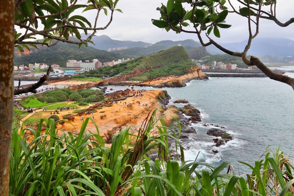
Yehliu Cape Nature Reserve (野柳岬自然保護區) is a geological attraction located in northern Taiwan that consists of outlandishly shaped coastal rocks and boulders. Guitou Shan (龜頭山) is the highest and most prominent of the 2 named hills in the nature reserve at 74 meters (243 ft) in elevation.
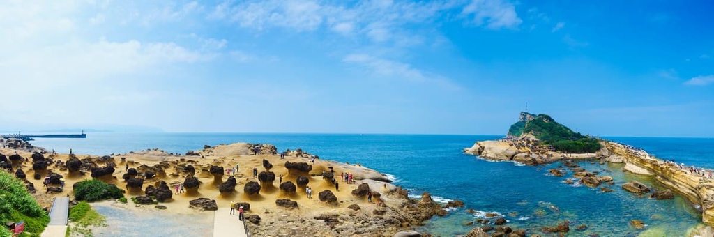
Yehliu Cape Nature Reserve, also known as Yehliu Geopark, lies in the seaside Yehliu Village of Wanli District (萬里區) in New Taipei City (新北市).
Here, the vicious coastal winds generate mammoth waves that whip the seaside rock with immense force. Yehliu lies in a peninsula; thus, the Pacific Ocean’s waters crash around it, creating a ring of weathered, eroded rocks. Over time, the sea’s battering shapes and molds the stone, creating intriguing sculptures of the shoreline boulders.
As Yehliu Cape Nature Reserve lies on the north-eastern coastline, it is exposed to winter’s northeast monsoons and summer’s volatile typhoons. Thus, the intensity of these annual storms creates powerful waves that smash against the coast, further molding the rock into the shapes that we see today.
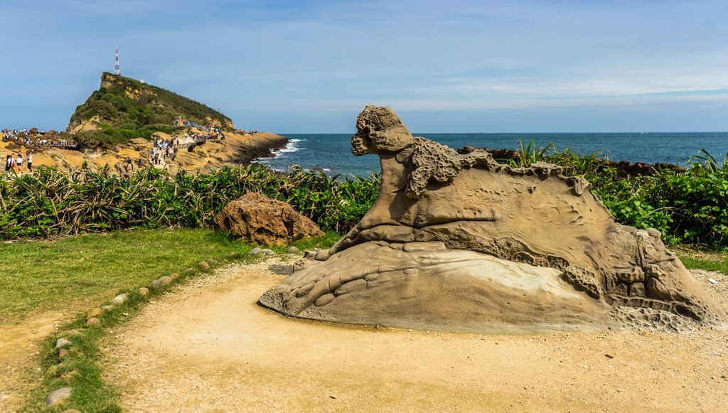
There are approximately 180 striking rock formations along the 1.7 km (1 mi) long craggy shoreline of the reserve, which covers a total area of 23 ha (57 acres). The most fascinating and popular of Yehliu’s outcrops is the Queen’s Head (女王頭), which looks a lot like a slender, regal neck and a composed face with a high crown on its head.
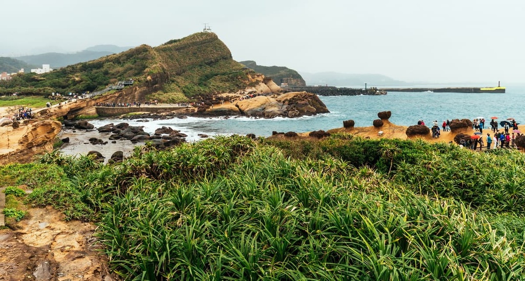
Yehliu’s highest hill, Guitou Shan, literally translates as ‘turtle mountain’ in English. This is a fitting name as the hill’s body greatly resembles a turtle that’s ready to dive into the Pacific Ocean. Yehliu’s other hill, Lou Tou Feng (駱駝峰), stands at 26 meters (85 ft) in elevation.
While Yehliu Cape Nature Reserve is a famous attraction in northern Taiwan, there are many other wondrous destinations nearby that are worth checking out.
For example, Jiufen (九份), the ancient hillside gold mining town, lies to the southwest of Yehliu. Taipei’s (臺北市) lush garden, Yangmingshan National Park (陽明山國家公園), is also situated to the west, while to the northwest, Taiwan’s Sanzhi District (三芝區) houses the Linshabi Nature Reserve (麟山鼻自然保護區).
Yehliu's hills form the eastern extension of the Datun Volcano Group (大屯火山群), which is mainly concentrated in Yangmingshan National Park. Around 1 million years ago, volcanoes in northern Taiwan sporadically erupted. This tectonic activity created the sedimentary and volcanic hills that we see to this day.
Yehliu's rock strata consist of a Daliao layer of sandstone and shale from the Miocene epoch. Yehliu was once an underwater area where sediment accumulated on the seafloor.
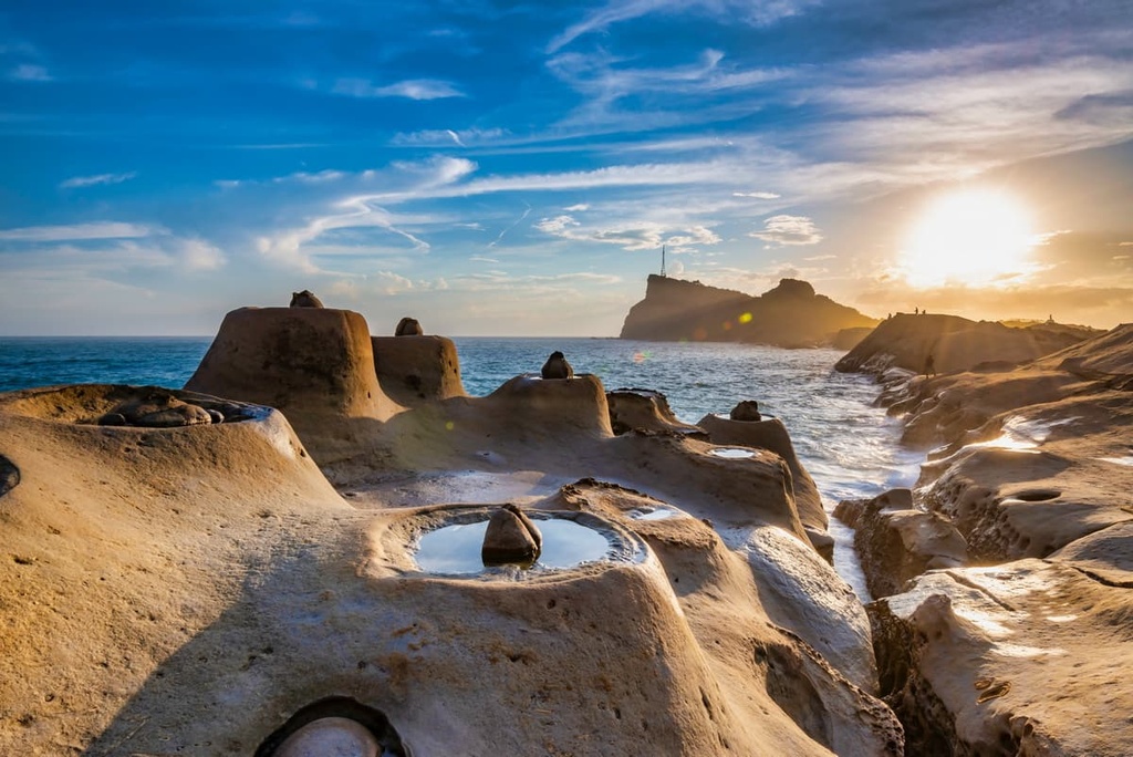
Meanwhile, the long chimney-like hoodoo rocks that appear along Yehliu's coast are a relic of its underwater past. These tall rocks are usually found in dry, arid areas, such as the deserts in the US state of Utah, so their presence on northern Taiwan's coast is quite bizarre.
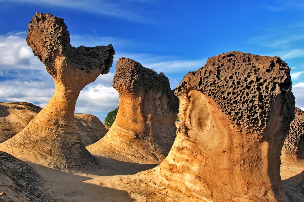
An assortment of other rock formations can be found along Yehliu’s weathered coast, too, such as mushroom rocks, honeycomb weathering patterns, conical rocks, and sea caves.
While Yehliu Cape Nature Reserve’s main attraction is its fantastical weathered rocks, the reserve also features an abundance of plant life. Various evergreen and deciduous shrubbery appear in Yehliu’s verdant coastal areas, such as shell ginger, giant taro, and the Taiwanese cheesewood.
Meanwhile, a large acacia tree community forms a natural barrier between the coast and the inland areas of the reserve. Here, coastal plants bloom across the shore, such as sea lemon and saddle vine.
As Yehliu is the doorstep to the Pacific Ocean, it is a welcome respite for birds from mainland China and Korea that migrate to Taiwan for the sunnier and milder winters. The osprey, hoopoe, and the peregrine falcon are some of the 80 species of birdlife that have been spotted in the reserve to date.
People have long relied on fishing to survive in what is now Yehliu Cape Nature Reserve. However, when compared to its neighboring mining communities of Jiufen and Jinguashi (金瓜石), Yehliu Village could not compete with the prosperous gold production; therefore, it has historically been a less affluent community.
As the villagers had little money, they would extract coastal sandstone and coral to build houses and shops. As Yehliu’s outcrops are now protected in the nature reserve, villagers can no longer do this. However, significant economic advancements were made in this otherwise sleepy fishing town once Yehliu’s rocky coast became a well-known tourist destination.
Another one of Yehliu’s features is its lighthouse. Resembling something out of a science fiction movie, Yehliu Lighthouse, which was built in 1967, has an elongated neck with a flat ring encircling its base. The international lighthouse community has applauded its innovative design.

Here are some of the best hiking trails and areas in and around Yehliu Cape Nature Reserve.
For those wishing to admire Yehliu’s unique geological sculptures, the Yehliu Cape Mountain Trail is a great choice. This 4 km (2.4 mi) trail forms a loop route around the headland of Guitou Shan, passing by Yehliu’s famous landmarks, such as the Queen’s Head and the Yehliu Lighthouse, along the way.
After the first 500 meters (1,640 ft) of the trail, you will encounter Yehliu’s most well-known rock formation, the Queen’s Head. Due to the continuous weathering and erosion on the rock, this regal structure is gradually changing shape. While you can still distinguish its noble features, a fiberglass replica stands next to the rock so you can see what it used to look like.
The path then ascends Guitou Shan, where birds encircle the skies and rest on the hill’s shrubbery. At the top of the mountain, you’ll find the sleek candle holder-styled Yehliu Lighthouse, which is a much sought-after structure for its shape and design. From Guitou Shan’s summit, you can admire the intense cadence of the Pacific Ocean’s endless waters as they rise and fall.
The path then starts to loop back so you can continue to marvel at Yehliu’s numerous rocky creations, such as a collection of conical mounds, which are known as the candle-shaped rocks because they look like burnt down candles.
Along the way, you’ll also see many honeycomb rocks dotting the landscape. There are also a number of mushroom rocks found along the trail that you can enjoy.
While most people associate Yehliu Cape Nature Reserve with its famous rockwork, some are surprised that the area is not all sand and stone. A thriving tree community exists in the area, too. On the Yehliu Hiking Trail, you’ll climb to the top of Lou Tou Feng where you can admire the glorious views of Yehliu.
This short 2 km (1.2 mi) path has a gentle incline and is surrounded by a dense acacia forest. Once you reach the top of Lou Tou Feng, you will get a bird’s eye view of Yehliu’s stone sculptures. Bordering the peninsula on either side are Yehliu’s two fishing ports. You can even see the fishing boats as they sit on the crystal waters, waiting patiently for their catch.
Furthermore, you can admire the lustrous Emerald Bay (翡翠灣) along the coast, which is known for its inviting aquamarine waters and its water sports opportunities. You might even spot adventurous paragliders as they soar through the skies and surfers as they ride the heavy northern Taiwan swells.
The path ventures past Yehliu’s old houses, which were built with coral and sandstone. as you head downhill. You can also pay a visit to Yehliu’s oldest shop, Maroon Residence, which began trading 100 years ago.
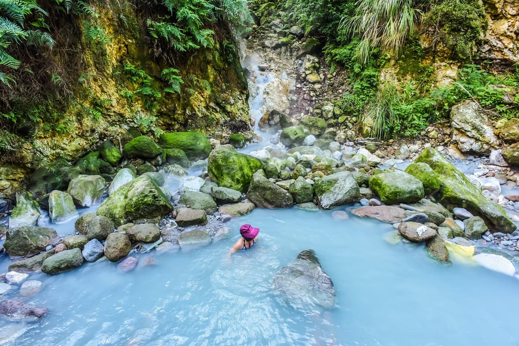
The high levels of volcanic activity in northern Taiwan have given rise to a proliferation of hot springs in the area. On great hot spring to check out is the Jinshan Hot Springs (金山溫泉), which are situated in New Taipei City's Wanli District, facing the ocean.
Taiwan's northernmost hot spring features four distinct springs that emerge from its rock fissures: a salty seawater spring, a carbonic acid spring, a sulfur spring, and an iron oxide spring. For this reason, Jinshan Hot Springs is subdivided into three parts: Jinbaoli Hot Spring, Huanggua Hot Spring, and Jiatou Hot Spring. The temperature of the waters in each pool range between 45 to 86°C (113 to 187°F).
Taiwan is one of just a handful of places worldwide that feature a seaside hot spring. Here, you can soak in the simmering mineral waters and watch the sunset slowly infuse the twilight sky in warm amber hues. The acidic water's benefits are two-fold: leaving the skin moisturized and improving blood circulation.
Another area of interest around Yehliu Cape Nature Reserve is the romantic escape of Lovers Lake (情人湖). Situated in Keelung City (基隆市), near Yehliu, this lake is located on the side of Dawulan Shan (大武崙山).
The scenic splendor of Lover Lake’s bottle green waters winding along a dense forest of thriving evergreen sandalwood and the Japanese bay tree is what draws nature enthusiasts to its lovely landscape. Furthermore, there are two hiking trails that travel along Lovers Lake’s coastline and through its nearby forests.
The lakeside trail is 1.4 km (0.8 mi) in length, and it traces the irregular shaped pond. As the forest vegetation is lush and swarming with greenery, the excessive plant life releases phytoncides, the compound linked to the positive effects of forest bathing.
When inhaling phytoncide’s tranquilising effects, you can savor the eucalyptus tree’s rich, wooded scent. Additionally, as you roam along this trail, you can capture great views of Keelung from the designated viewing decks along the hillside.
Furthermore, a delightful octave of birdsong often echoes through these shaded woods and the enchanting sight of butterflies flitting through the emerald greenery is not uncommon. The forest’s flowering trees also bloom and add a rainbow of color to the leafy foliage in spring and summer.
The other route is the 1.6 km (1 mi) long mountain trail, where you leave the lake behind and hike along the hill’s ridgelines.
When walking the more challenging path that ascends Dawulan, you’ll get to enjoy a forest of acacia and cedar. Along the route, you can admire Lovers Lake from above while also observing Yehliu’s geological coastline and Keelung’s bustling port.
The most convenient places to stay near Yehliu Cape Nature Reserve are the northern Taiwan cities of New Taipei City and Keelung. Here’s what you need to know before your trip.
While Taipei may be Taiwan’s capital, New Taipei City is Taiwan’s largest city and it is filled with excellent attractions. Additionally, New Taipei City’s northeastern coastline is famed for its eroded outcrops that form the most striking shapes and colors.

If you are fascinated by Yehliu’s rock formations, be sure to pay a visit to New Taipei City’s Nanya Rocks in the Northeast Coast Reserve (東北角沿海保護區). The Nanya Rocks have undergone thousands of years of weathering that have cut the sandstone into columns of patterned rock. As this sandstone also contains iron ore, Nanya Rocks’ ombre appearance of dark chocolate, rusty red, and milky whites make for a striking color pattern.
Another intriguing geological area in New Taipei City is Jinguashi’s Golden Waterfall. Situated along North 34 Highway is an old iron mining post with golden amber crags. The stone oxidizes and forms its burnt orange color as the water touches the iron pyrite rock. As the Golden Waterfall reaches the sea, you can witness the yellow river waters as they enter the sapphire sea.
Furthermore, the Yin and Yang Sea is the swirling combination of saffron and cerulean blue waters where the Golden Waterfall’s waterway merges with the Pacific Ocean. The seaside is lined with a trail of eroded boulders that glisten gold under the sun from the iron pyrite infused stream.
There are many viewing decks along the sea where you can marvel at the wondrous multi-colored waves. The full view of the Yin and Yang Sea is beautiful as the nearby verdant hills of Keelung Mountain (基隆山) and Baoshishan (報時山) hug the coast.
Another of New Taipei City’s geological attractions is Bitou Cape. Here, you can wander a 3.5 km (2.2 mi) hiking trail along gentle coastal hills to enjoy sweeping views of the Pacific Ocean and New Taipei City. One of the highlights of the trail is the spectacular group of weathered honeycombed sea rocks and the elongated hoodoos. Visitors love to frequent this trail during sunset, as the Pacific Ocean reflects twilight’s dazzling hues.
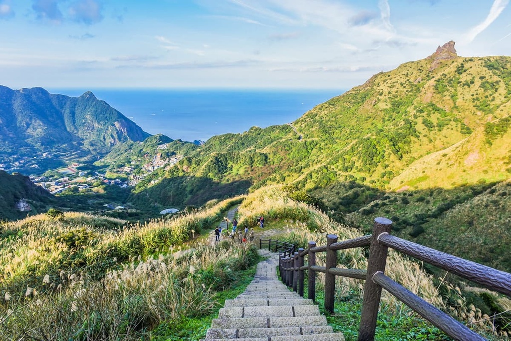
Another popular hiking trail is the trek to Teapot Mountain (無耳茶壺山). The hill has a curved, tall shape that greatly resembles a teapot without a handle. Additionally, Teapot Mountain Hiking Trail has it all: a slightly challenging 4.2 km (2.6 mi) path, hillside caves, pristine nature, stunning scenery, and impressive views. From the summit, you can even see the Yin and Yang Sea.
While most visitors flock to the vibrant capital of Taipei in northern Taiwan, Keelung City offers a more serene and relaxed pace of living that visitors may not feel in Taipei’s endless playground of activities. If you seek an escape from the crowds, Keelung City’s rustic charm is well worth checking out..
Two islands lie off Keelung’s coast, one of which is connected to the mainland by a bridge. The closer Heping Island features a weathered beach of peculiar shaped geological creations. Alternatively, just a short ferry ride away is Keelung Islet. Formosan lilies flourish throughout the small island in spring, and walking the forested hill provides scenic views of Keelung City.
You can also enjoy another mesmerizing view of Keelung from Zhongzheng Park, which is located near the coast. From here, you can get great views of Keelung’s bustling port. Alternatively, you can check out the immaculate and striking four-story Zhuputan Temple, which sits on the hill near the city and offers great views of the region.

For a mix of history and more views, Dawulan Fort is a worthwhile option. Situated on Dawulan Shan, this site was once a military stronghold protecting Keelung City from any unwanted sailboats.
While the exact construction of the fort is unknown, it was renovated between the Qing dynasty’s Guangxu’s reign in 1871 and the end of the Japanese Occupation Era in 1945. While marveling at the pristine condition of Dawulan Fort, you can overlook Keelung’s port from a different angle and gaze as far afield as New Taipei City’s Jinshan and Wanli districts.
One of Keelung’s top attractions is its old harbor, which is one of Taiwan’s most industrious ports. Keelung Harbor’s history is embedded in its ancient, dilapidated structures that have received a fresh coat of bright paint to renew life into this scenic waterfront. You can marvel at the grand liners docked in the moorings while choosing from a wealth of vendors to enjoy the freshest seafood during your trip.
Finally, on the northern edge of Keelung port is the Buddhist shrine known as Fairy Cave. The walls of this limestone grotto have been carved to create images and statues of the Buddha. While walking in the dark, dimly lit cavern tunnels, you can navigate your way through the cold, narrow passageways to discover Fairy Cave’s four sanctuaries.
The most convenient way to get to Yehliu Cape Nature Reserve is from Taipei.
From Taipei, you can make your way to the Taipei City Hall MRT Station, which features a bus terminal. Catch the Guoguang 1815 bus headed to Jinshan Youth Activity Centre. Alight at the Yehliu Station stop, which is a 10 minute walk to Yehliu Cape Nature Reserve.
If you would like to drive to Yehliu Cape Nature Reserve, you can make the 34 km (21 mi) journey from Taipei, or the 26 km (16 mi) drive from Keelung.


