
Scan the QR code and open PeakVisor on your phone
Mandarin Duck Lake Nature Reserve has 3 named peaks. The highest is Xiqiusishan at 2,427 m. Other notable peaks include Dongqiusishan and Dongbaojinhanshan.
Mandarin Duck Lake Nature Reserve (鴛鴦湖自然保留區) of northern Taiwan features towering mountains and a beautiful alpine lake. The reserve houses a number of protected plant species as well as 3 named mountains. The highest and most prominent peak in the reserve is Xi Quisi Shan (西丘斯山) at 2,427 metres (7,963 ft). This place is inaccessible by general visitors. It only allows academic, research-oriented, environmental purpose visitors who have applied for permissions in advance to enter.
Mandarin Duck Lake Nature Reserve (鴛鴦湖自然保留區) is located in the Jianshi Township (尖石鄉) of north-eastern Hsinchu County (新竹縣) in Taiwan; however, the 374 ha (927 ac) of land in the reserve stretches across the borders to Hsinchu County (新竹縣), Yilan County (宜蘭縣), and Taoyuan City (桃園市).
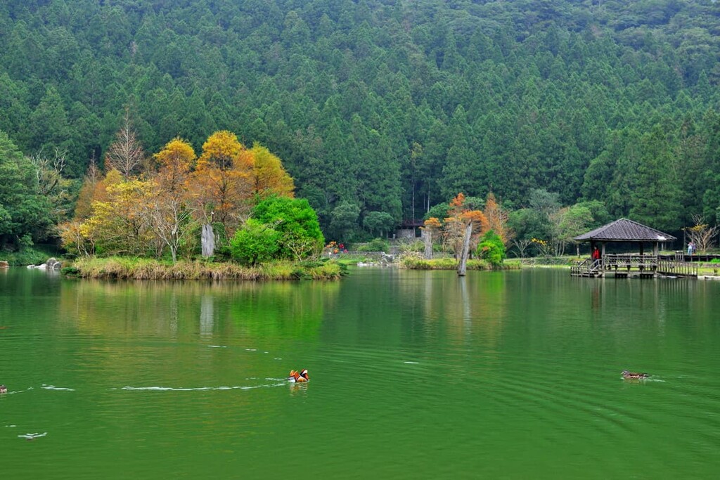
Mandarin Duck Lake, also known as Yuanyang Lake, comprises 3.75 ha (9.3 acres) of water body, with marshland making up about 2.2 ha (5.4 acres) of that area. The remaining 368.1 ha (910 acres) of the reserve features mountain terrain.
The elevation in this hilly region ranges between 1,650 to 2,427 metres (5,413 to 7,963 ft) above sea level. Mandarin Duck Lake sits at an elevation of 1,670 metres (5,479 ft). This narrow and 595-metre-long (1,952 ft) alpine lake is not only high in elevation, but its depth even reaches 15 metres (49 ft). Furthermore, Mandarin Duck Lake is the uppermost river headwater tributary of the Tahan River watershed.
Out of the three named mountains in this area, the two other prominent mountain, besides Xi Quisi Shan, are Dong Qiu Si Shan (東丘斯山) and Dong Bao Jin Han Shan (東保津寒山).
Within the park, there is a humid and foggy climate year-round and the northeast monsoon heralds a turbulent heavy rainfall from October to March. Temperatures can fluctuate between a freezing 23°F (-5°C) in winter to a sweltering 82°F (28°C) in summer, with the average annual temperature sitting around a mild 55°F (13°C).

Mandarin Duck Lake Nature Reserve lies in the south-western boundaries of Qilan Wildlife Reserve (棲蘭野生動物重要棲息環境), with Shei-Pa National Park (雪霸國家公園) resting just outside the reserve. Furthermore, Chatianshan Nature Reserve (插天山自然保留區) sits to the north of the reserve while Taipingshan National Forest Recreation Area (太平山國家森林遊樂區) in located to the east, and Taoyuan City’s most prominent mountain Tayux Moyang (泰矢生山) looms to the west of the area.
The mountains of the Mandarin Duck Lake Nature Reserve extend northward from the extensive Xueshan Range (雪山山脈) that stretches from west-central Taiwan in Nantou County (南投縣) to the coast of northeast Taiwan in New Taipei City (新北市). One of the five major mountain ranges in Taiwan, Xueshan Range is the northernmost mountain range in Taiwan.
The rock strata in the reserve are mainly composed of sedimentary and metamorphic rocks from the Tertiary period combined with quartz and shale from the Oligocene epoch and sandstone from the Miocene epoch. A steep mountainous landscape is created from the fragile slate that has undergone erosion and corrosion; thus, the nearly vertical mountains are at risk of landslides.
Mandarin Duck Lake was formed as a result of a landslide. The sediment from the landslide created a concave canyon that eventually filled with water to become the lake.
The vegetation in the reserve is typical of a montane forest ecosystem. With a few conifer trees found in areas over 1,800 metres (5,906 ft), the forest is home to Machilus-Castanopsis species, while Ficus-Machilus species dominate at lower elevations.

The forests of Mandarin Duck Lake Nature Reserve are divided into two plant communities: a coniferous hardwood community and a swamp or early succession plant community. Taiwan red cypress and Taiwan cypress are distributed in the fog zone, and Chinese hemlock are the primary confierss, while Rhododendron mariesii and Rhamus species are the primary hardwood species.
Vegetation in the swamp consists of the aquatic plants Potamogeton octandrus, Sparganium fallax graebner, and bog bulrush, with Miscanthus transmorrisonesis and Schoenoplectus morrisonensis hayata constituting the early succession plant community.
Sparganium fallax graebner is a rare and protected perennial herbaceous aquatic plant species that grows in Mandarin Duck Lake. Taiwan cypress, a surviving relic from the last major glaciation, is also a protected species in the area due to its increasingly rare population.
The plant ecosystem includes epiphytes, which comprises mosses and liverworts, while 185 vascular plant species dominate the region.

The natural environment of Mandarin Duck Lake Reserve creates favourable habitat for wildlife. The Mandarin duck is the primary migratory bird species in the area, hence the name of the lake. However, the presence of mandarin duck in recent years has significantly and worryingly dropped.
The Mandarin rat snake is a regionally rare reptile that inhabits the marshland. Noteable birds in the reserve are the Mandarin duck, besra, crested serpent-eagle, mountain scops-owl, and grey-faced woodpecker.
Mandarin Duck Lake Reserve is situated in the mountainous traditional lands of the Atayal in what is now Jianshi Township in Hsinchu County.
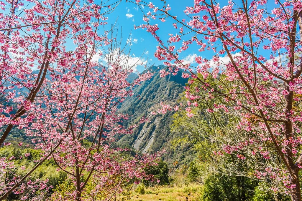
The nearby mountain village of Smangus (司馬庫斯) is an Atayal settlement at an elevation of 1,500 metres (4,921 ft). It is famous for being one of the most remote communities in Taiwan. It is now a popular tourist destination, thanks to its rich cultural history and mountainous charm.

The Mandarin Duck Lake Reserve was established on June 27, 1986, which makes it one of the earliest nature reserves to be created in Taiwan. As Mandarin Duck Lake Reserve houses unique plant species, the area is blocked off from tourists to lessen the human impact on the natural environment as academic and scientific research is conducted in this area.
Since Mandarin Duck Lake enjoys a unique geography, remote location, and a subtropical climate, it is a perfect area for research on long-term ecological changes in Taiwan. As a result, since 1995, when the National Science Council formally established ‘The Long Term Ecological Research Program’, research has been continuously conducted in the Mandarin Duck Lake Reserve region.
The area of Mandarin Duck Lake is closed to entry for the general public because it is reserved for research purposes. However, two of the mountains surrounding the lake are popular peaks to summit as part of an extended hiking trail, with sharp, challenging gradients and journeying through thick verdant forests.
While the start and end of the Smangus Ancient Road Trail loop fall outside of the boundaries of Mandarin Duck Lake Reserve, part of the trail ascends Xi Qiusi Shan, the highest mountain in the reserve. This lengthy hike takes most people three days to complete; thus, hikers often camp on the trail for two nights.

Hikers begin this challenging 20.3 km (12.6 mi) trek from the Smangus Tribe Visitor Centre. Here, they will encounter a woodland of sacred giant cypress trees, the highest of which looms above at 35 metres (114 ft) and is known as Yaya Giant Tree. ‘Yaya’ means ‘mother’ in the Atayal language. The Atayal greatly respect ancient trees in their culture; thus, giant and old trees are revered and admired.
Hikers will then continue on the path towards Xuebai Camp for an overnight rest. Along the way, they’ll cross bumpy, uneven, and rocky terrain near the Shuangxi River. Hikers will also pass through a verdant virgin forest with opulent velvet icicles of emerald moss draped from the thick branches of towering cypress trees.
The following day hikers embark towards Tayux Moyang, also known as Xuebaishan or Snow White Mountain, which intersects Hsinchu County and Taoyuan City. A dense forest of furry epiphytes completely engulfs the abundant cypress trees as hikers progress through the primitive forest. Here, they’ll walk over a carpet of crunchy leaves toward the overgrown summit of Tayux Moyang, which offers no views beyond the thicket of woodland.
Hikers will then descend the steep saddle of Tayux Moyang then head towards Xi Qiusi Shan. Along the way, they will laboriously climb a sheer perpendicular gradient while appreciating the opening of the dense forest canopy offering views of the precipitous mountainous landscape. The view from Xi Quisi Shan is epic as a backlog of misty blue mountains stretch as far as the eye can see.
Hikers can note the northern peaks of Babokulu Shan (巴博庫魯山), Fuxing Jianshan (復興尖山), Tamanshan (塔曼山), and Meiguximo Shan (玫瑰西魔山) in the distance. From the south, Dabajianshan (大霸尖山) in Shei-Pa National Park can be seen standing tall, with the Holy Ridge in distinguishable view.
Hikers descend the mountain and stay overnight at the Xuebai Camp before making their way back towards the Atayal village of Smangus the following morning.
Like the Smangus Ancient Road Trail, the Galahe Mountain Pass O-Shaped Vertical Trail stretches beyond the boundaries of the Mandarin Duck Lake Reserve. Nevertheless, it summits two mountains in the reserve, Xi Quisi Shan and Dong Quisi Shan, and an additional three mountains outside of the reserve, Tayux Moyang, Tangsui Shan (唐穗山), and Lengshan (稜山).
Hikers begin this trail in the Red River Valley as they walk along an Atayal ancient road. This road leads through a verdant woodland of arrow bamboo after which they enter an alpine forest of rhododendron before ascending the most prominent peak in Taoyuan City—Tayux Moyang. After an overnight rest stop at Xuebai Camp, hikers then tackle the spectacular panoramic Xi Qiusi Shan to admire the backdrop of mountain peaks, before heading east towards Dong Qiusi Shan.
This journey is ripe in arrow bamboo, and the path is gentle, although some bamboo may be blocking the way, so it's best to look underneath for the proper line of the trail. A mass of fallen trees often lays heavy on the forest floor, creating a natural obstacle course for hikers to scramble.
The summit of Dong Qiusi Shan is sheltered, so there is no grand view on display. Hikers will then descend the mountain along a path of fallen trees and enter an enchanted forest. Afterward, hikers head towards the foggy, cloud-covered Tangsui Shan, which also offers limited views.
Hikers stay in overnight accommodation at 130 Forest Road after descending Tangsui Shan. This path takes you through a rhododendron forest before heading out to Lengshan, the final peak of the trail.
A field of towering Chinese silvergrass greets hikers as they ascend the intermediate path towards the sheltered summit of Lengshan. As hikers descend the last mountain of this course they complete the circular trail by making their way towards the Shuangxi Stream and ending at the Red River Valley. Along the way, a woodland of giant cypress trees line the hilly paths, but as hikers descend below 1,500 metres (4,921 ft) a mixed woodland of Chinese hemlock and rhododendron.
The Yuanyang Valley Waterfall Trail spans a pleasant 3.6 km (2.2 mi), leading hikers along a disused old road towards the heavenly majestic Yuanyang Valley waterfall. The sweltering Taiwanese sun cannot reach through the dense forest canopy covering the trail; thus, the path is cool and, at times, a bit chilly. Even in the heat of summer, the water itself is frigid.
Starting from the entrance of the paddy field road, 200 metres (656 ft) from the turnoff from Country Road 120, hikers embark on a gentle trail that leads their way through a forest of arrow bamboo toward the spectacular waterfalls. The main waterfall is the turquoise pool created from the silky stream of the three-level Yuanyang Waterfall. The sound of cicadas signals your proximity to the waterfall, as the sound is soon replaced by roaring waters crashing from 30 metres (98 ft) high.

As the Mandarin Duck Lake Reserve is located in Hsinchu County, the closest city nearest to the reserve is Hsinchu City (新竹市), although it is still a long drive. Neiwan Township (內灣小鎮) is another possible place to stay as it is just a few hours drive of the reserve. The mountain village of Smangus (司馬庫斯) is also an option for visitors wanting to stay in a remote location in Taiwan.
Hsinchu City is a delightful and refreshing fusion of nature, culture, and entertainment. One of the earliest areas in Taiwan to be developed, Hsinchu is brimming with history and offers visitors an authentic display of Taiwan life.
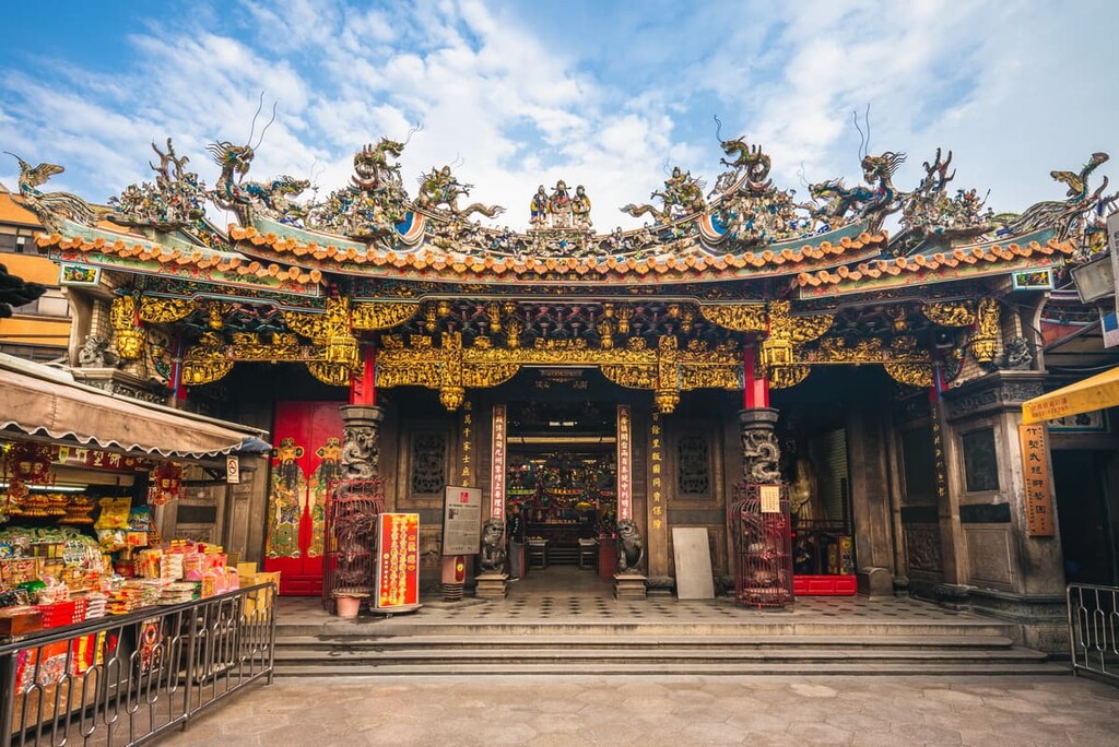
A landmark of Hsinchu, the Hsinchu City God Temple, holds the highest ranking of the City God Temples in Taiwan; therefore, it is a bustling place of worship.
While it is steeped in importance, what makes this temple even more notable is that it is surrounded by vibrant market stalls in the courtyard, all of which offer visitors a chance to taste the local delicacies of bee-hoon noodles, guo-guo thick soup, omelettes, and fried chicken. Additionally, traditional Taiwanese opera is performed from this very courtyard, providing visitors with entertainment after a meal and prayers.
The Eighteen Peaks Mountain Park in the east district of Hsinchu is a top-rated destination for people of all ages and abilities due to the progressive gentle gradients of the park’s many hills. A long winding road spanning 8 km stretches across this hilly region of thick forests that shelter hikers from the intense heat and scorching summer sun. Shibajianshan (十八尖山) is the highest hill in the park at 134 metres (440 ft).

The quaint and charming indigenous Hakka village of Beipu offers tourists a glimpse of the past as this area has been carefully restored and maintained. As visitors stroll along the narrow alleyways of Beipu Old Street, a display of historical buildings and delicately decorated temples are unveiled. An ample amount of teahouses and food stalls line the streets, offering a taste of Hakka cuisines, such as ground tea and persimmon cakes.
Hsinchu Moat Park is the only remaining moat in Taiwan that has been transformed into a riverbank park. The vibrancy of the nearby flora attracts visitors to the canal, where local artwork is displayed along the pebbled walls. At nighttime, this moat becomes a grand spectacle as a fluorescent light display illuminates the area, casting a mirror of light on the moat water and creating a stirring extravaganza of light.
For thrill-seekers, the biggest theme park in Taiwan is situated just outside Hsinchu City. Leofoo Village Theme Park offers more than thirty roller coaster rides with five different areas to explore. Visitors can experience the park’s furiously fast and thrilling rides as well as an animal safari adventure and a waterpark.
A hamlet of Hakka culture wedged in the mountains, Neiwan is a perfect stay for nature lovers who want to immerse themselves in the ancient traditions of the Hakka people.
Neiwan is the last stop on the Neiwan Line from Hsinchu. This remoteness can be felt from the vast scenic sprawling of lush forests with towering hills acting as gatekeepers to this traditional community.
A wonder along Neiwan Old Street is ideal to appreciate the ancient wooden architecture from this once thriving town used as a passage to transport logging and minerals. A thrall of street vendors happily welcomes visitors to their beautiful village. Hakka cuisine is amply offered, such as wild-ginger-flower-rice dumplings, Hakka musk, purple Jada cabbage, and Hakka tea.
Five suspension bridges grandly stand over the Youluo River, a hotbed for fishing activities, such as catching shrimp and crab, which can be barbecued to enjoy.

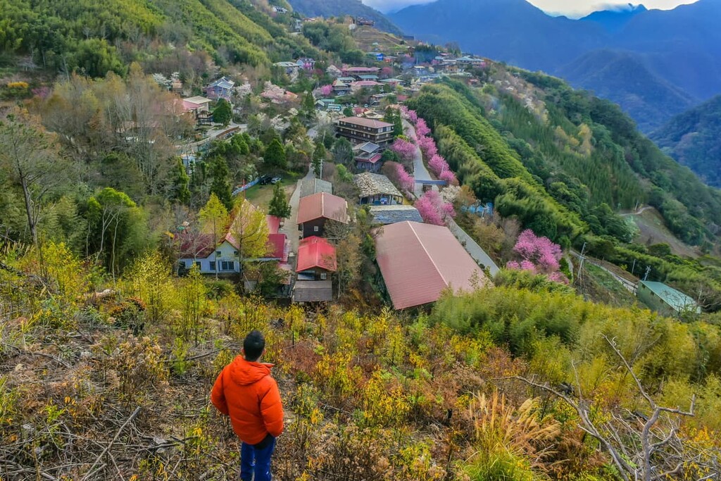
One of the enjoyments about staying in Smangus is the feeling of being entirely submerged in one of Taiwan's remote alpine villages. Smangus was only connected to electricity in 1979, demonstrating how its remote location has delayed the development of modern living.
The hidden nature of the village preserves an atmosphere of tradition and Atayal culture that has been nurtured throughout time. Indigenous Atayal singing and dancing ceremonies are performed with locals wearing traditional Atayal clothing. Locals also offer visitors to join in when making the customary Atayal dessert, mochi.
The picturesque beauty of this highly elevated mountain village is one of its main features. A forest of giant cypress trees can be reached by foot along one of the many verdant mountain trails that extend across this lofty region.
From the major cities of Taipei, Taoyuan, Taichung, Chiayi, Tainan, and Kaohsiung, take the Taiwan High Speed Rail (HSR) or the express train (TRA) to Hsinchu City. Once in Hsinchu, head to the Hsinchu TRA station to take the Neiwan Line train to Neiwan.
From Neiwan, there are no public transport options to get to Mandarin Duck Lake Reserve. Also, as entry into the reserve is limited for research purposes, the closest stop to the reserve is Smangus, which is in close proximity to the abovementioned trails.
It is best to rent a car or scooter or to hire a taxi as transport from Neiwan to Smangus. The total mileage is 60 km (37 mi) and the journey takes up to two and a half to three hours due to the narrow winding roads up the mountain.


The highest peak in Mandarin Duck Lake Nature Reserve is Xiqiusishan, at 2,427 m.
Notable peaks in Mandarin Duck Lake Nature Reserve include Xiqiusishan, Dongqiusishan and Dongbaojinhanshan.


