Scan the QR code and open PeakVisor on your phone
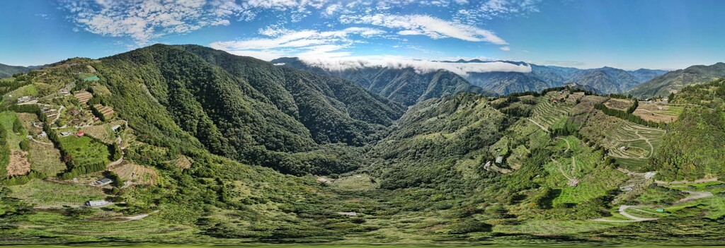
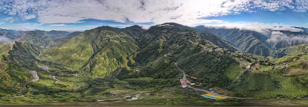
Chatianshan Nature Reserve (插天山自然保留區) is a protected mountainous region that’s situated partly in the vicinity of Dongyanshan National Forest Recreation Area (東眼山國家森林遊樂區) in northern Taiwan. There are 17 named mountains in the region with Tamanshan (塔曼山) being the highest and most prominent at 2,130 metres (6,988 ft) in elevation.

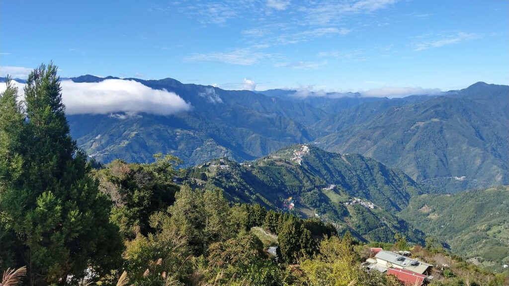
Chatianshan Nature Reserve contains a land area of 77 sq. km (30 sq. mi) extending across the Sanxia District (三峽區) of New Taipei City (新北市) and the Fuxing District (復興區) in Taoyuan City (桃園市). The area encompasses low-lying valleys and lofty peaks, and, as such, the elevation ranges between 300 to 2,130 metres (984 to 6,988 ft) across the nature reserve.
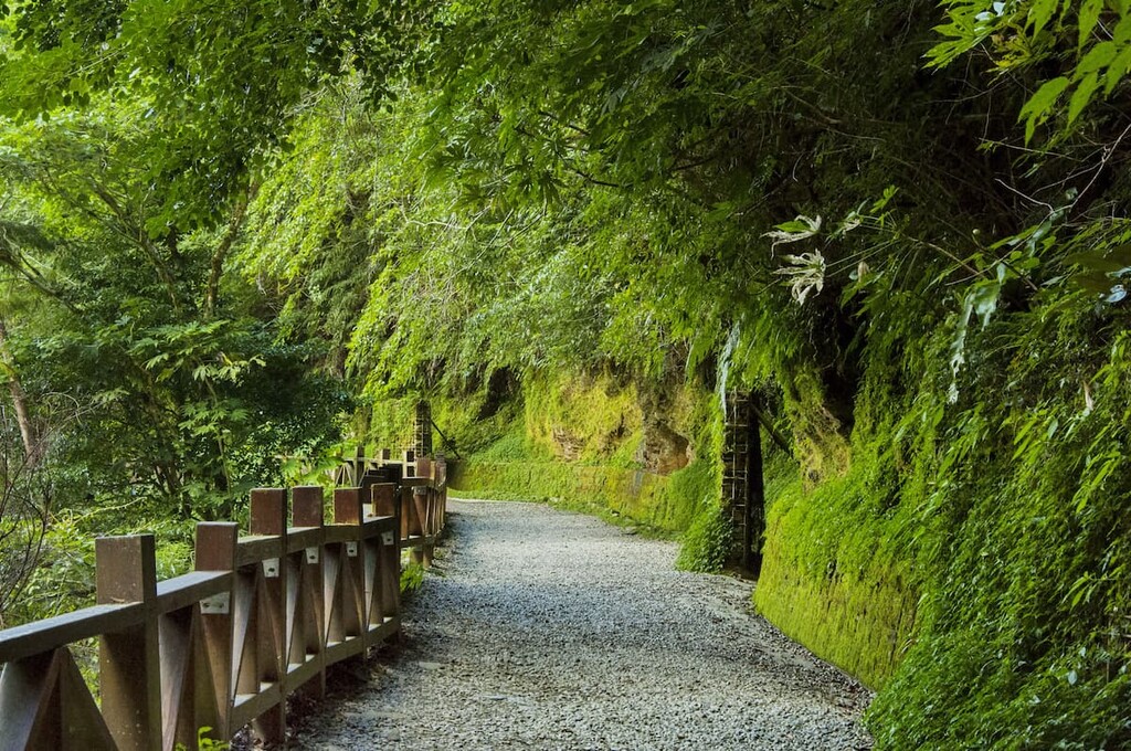
Misty mountain forests, the presence of imposingly gigantic and ancient trees, and the physically challenging nature of summiting the precipitous mountains that are mostly submerged with thick vegetation that obstruct the views are the main attractions of Chatianshan Nature Reserve.
While Tamanshan (塔曼山) is the highest mountain in the park, other notable mountains include Lalashan (拉拉山), Lupeishan (魯培山), Nan Chatianshan (南插天山), Bei Chatianshan (北插天山), Fufushan (夫婦山), Heweishan (赫威山), and Wushan (巫山).
The mountains of Chatianshan form part of the highest ridge of the northern edge of the Xueshan Range (雪山山脈), extending northwards towards Taoyuan City.
The peak of Lalashan is placed in the centre of the nature reserve, with Nan Chatianshan (南插天山), Tamanshan (塔曼山), Lupeishan (魯培山), Fufushan (夫婦山), Guishan (檜山), and Chakenshan (茶墾山) forming a barrier around it.
The average annual temperature of this elevated region is around 59°F (15°C), with winter temperature ranging between 41 to 50°F (5 to 10°C) and summer averaging 68°F (20°C). The northeast monsoon affects the annual rainfall in the region, dropping about 3,290 mm (130 in) of total rain annually. However, this rainfall amount is spread out equally throughout the 12 month of the year as there is no distinct dry or rainy season in this region.
With the mild climate and heavy rainfall, the region is exceptionally humid, with relative humidity usually averaging at above 90 percent. This makes the region perfect for vegetation growth and it also adds a mystical hazy atmosphere as you hike.
Areas of interest near Chatianshan Nature Reserve include Taroko National Park (太魯閣國家公園) in the southeast, Shei-Pa National Park (雪霸國家公園) in the southwest, Xinfeng Mangrove Nature Reserve (新豐紅樹林生態保護區) in the west, Manyueyuan National Forest Recreation Area (滿月圓國家森林遊樂區) to the north and Fushan Botanical Gardens (福山植物園) to the east.
The peaks of Chatianshan Nature Reserve (插天山自然保留區) form an extension of the Xueshan Range (雪山山脈), a major mountain range that stretches from central to northeastern Taiwan. Xueshan Range was created from the upward shifting pressure of tectonic plates as steep ridges rose from the earth below.
The strata of the Chatianshan mountains primarily consist of sandstones and shales dating back to the Tertiary period. The topsoil found on the mountain peaks is characterised by podzol.
In Dongyanshan National Forest Recreation Area (東眼山國家森林遊樂區), which partially encompasses the northern section of Chatianshan Nature Reserve, there is a forest road that contains fossils dating back tens of million of years. These fossils show evidence that this was an underwater area before tectonic activity in the region created both the island of Taiwan and its lofty peaks.
The difference in elevation and the mild climate in the region has led Chatianshan to become a highly biodiverse area.
As the elevation changes in the park, so does the plant life. In particular, Ficus-Machilus is dominant in the low elevation areas, followed by a Castanopsis pubescens forest belt. A zone of oak trees is prevalent in the medium to high elevation region, while a coniferous forest is found above 1,800 metres (5,905 ft).
An important ecological feature of the nature reserve is the presence of the endemic Taiwan beech. In fact, the park is effectively the southernmost limit of Taiwan beech distribution in the northern hemisphere. Taiwan beech can grow to be more than 20 metres (66 ft) in height with a diameter greater than 70 cm (28 in). This tree species is precious, especially in academic research on phytogeography.
The coniferous trees that sprout in high altitudes are mainly Taiwan red cypress, Formosan juniper, Taiwan hemlock, and Taiwan spruce. Around ten gigantic juniper trees have existed in the region for about 800 to 1,500 years and they are now considered landmarks of Lupeishan. Meanwhile, 18 massive Taiwan red cypress and Taiwan cypress trees stand at an elevation of 1,500 metres (4,921 ft) on Lalashan, with an average age range of between 500 to 2,800 years.
Plants growing along the trails include Rhododendron hyperythrum hayata, Enkianthus quinqueflorus (sometimes called the Chinese New Year flower as it begins to bloom just prior to the celebration), and the single-leaf orchid Pleione formosana.
The difference in vegetation along the forest zones shapes the rich flora and fauna found in Chatianshan Nature Reserve. The area is home to 23 species of mammals, of which the Taiwan black bear is one of the most endangered. The Formosan macaque, masked palm civet, Taiwanese pangolin, Taiwan sambar deer, and Taiwan serow are some of the other mammals present in the region.
There are 72 bird species found in the park, including the crested goshawk, Taiwan partridge, yellow tit, Mikado pheasant, cinereous vulture, and mountain hawk-eagle. Some of the endangered birds found in the park include the blue-bellied phoenix, crested serpent eagle, and the brown wood owl. Another creature near to extinction is the Nymphalidae species of butterfly Sasakia charonda.
As part of the Chatianshan Nature Reserve lies in the Fuxing District, the main Indigenous population of this region were the Atayal people who lived in the elevated regions of 1,000 to 1,500 metres (3,281 to 4,921 ft) above sea level.
Ancient mountain passages, such as Baling Old Trail, were built by the Atayal people as trading routes to visit other tribes. Wulai Mountain Village is a mountainous settlement of the Atayal people that still practices some traditional ways of living.
During the Japanese Occupation Era, police posts were stationed in the mountains to control the Atayal people, as the Japanese were interested in the mountain wood to create a logging industry.
The Atayal were most incensed about the presence of surveilling Japanese officers, thus tensions arose between the Atayal and Japanese. Over time, to gain control of the hilly area, the Atayal people were forcibly removed from their mountain homeland. Relics of the police buildings are still present along some of the trails in the area, notably the Fuba Traversing Historic Trail.

Daxi (大溪), an area close to Chatianshan Nature Reserve, was an old logging industry, and relics of the logging past are still featured in the region, such as skidders and a nursery. In an effort to preserve the rare and endangered animals and plant species of this region and to limit the number of people visiting these increasingly popular mountain trails, Chatianshan Nature Reserve was established on March 12, 1992.
The hiking trails of Chatianshan Nature Reserve feature verdantly covered mountain trails and beautiful scenery. Here are some of the most popular hikes to check out during your visit:
Before the entrance of Tamanshan, hikers pass through layers of a deciduous pine forest while the lofty peak of nearby Dabajianshan in Shei-Pa National Park can be viewed from the trailhead of Tamanshan.
The first 700 metres (2,297 ft) of the Tamanshan Hiking Trail are incredibly steep, and hikers need to use the fixed mountain ropes to haul themselves up the steep incline. However, the route begins to flatten out slightly afterwards and becomes easier to climb.
Along the Tamanshan Hiking Trail, hikers encounter colossal trees that touch the mountain sky as they twist and warp in peculiar shapes. For this reason, the Tamanshan Hiking Trail is referred to as the ‘magic forest’ as the giant distorted trees create a whimsical, mystical ambience in the deep mountain woods.
Due to the fact that Tamanshan is densely populated with woodlands of ancient trees, there are no views from the summit; however, the highlight of the hike is the passage through the cool, shaded forest tunnel with the crunching of leaves beneath your feet. The fresh, woody scent of cypress lingers in the forest air, allowing hikers to enjoy a sense of calm and tranquillity as they are entirely immersed in nature.
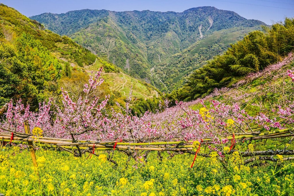
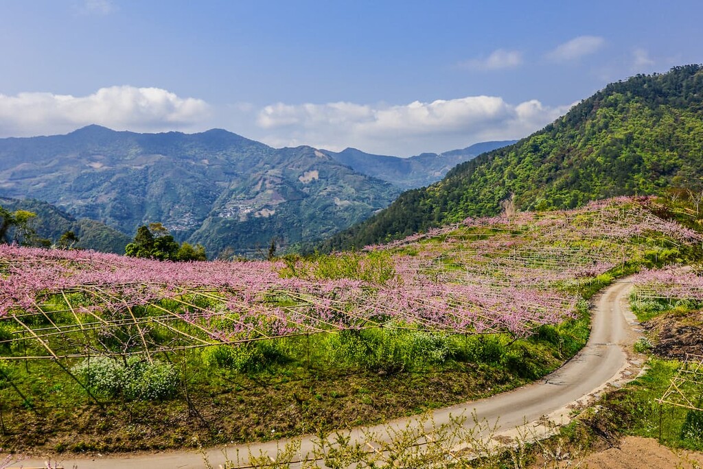
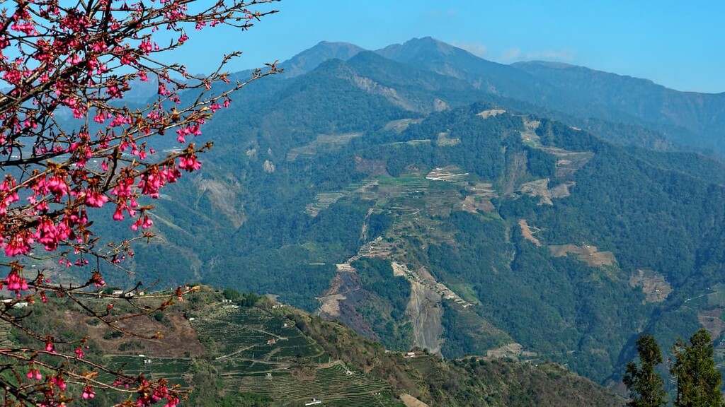
Lalashan was initially named Daguan Mountain by the Atayal people to pay homage to the beauty of the mountain, which is what ‘daguan’ means. This beauty is represented by the large clusters of green Chinese maple, red maple, and Taiwan beech that thrives in the forest.
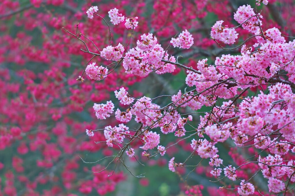
Every autumn, the mountain is painted in deep, crisp reds and golden, ochre yellows as the leaves gradually transform their seasonal hues. In addition, spring and summer add vibrancy and soft pastels to the mountain foliage as peach trees flourish.
The picturesque Lalashan Hiking Trail spans 3.7 km (2.3 mi) along a boardwalk forest trail that allows hikers to appreciate the giant trees that imposingly stand along a circular track. A total of 18 ancient and enormous trees line the route, ranging between 500 to 2,800 years old. Hikers can revel in the crisp mountain air containing phytoncide from the Taiwan red cypress and Taiwan cypress trees that form the Giant Tree path.
Giant tree number 1 is the tallest tree on the trail at 41 metres (135 ft) in height. It even has a broad circumference of about 9.8 metres (32 ft). It takes five adults with arms outstretched to wrap around the base of the tree. Giant tree number 5 is the oldest tree of 2,800 years, which is even older than Confucius.
The giant tree number 9 is the only Taiwan cypress on the trail and is a rare find as cypress does not normally grow at an elevation of above 1,500 metres (4,921 ft). In addition, it is also a two-generation tree as the original first-generation tree died; however, a younger tree has grown from the lifeless mass to form the second generation of the tree. The giant tree number 18 is the widest, with a circumference of 19.2 metres (63 ft).
Bei Chatianshan is a well-known mountain in the northern section of the Xueshan Range with a steep and straight shape. Bei Chatianshan appears as if it has been implanted upside down in the sky when the clouds roll in. Thus, the mountain is called Chatianshan, which translates as ‘mountain inserted in the sky.’ A temperate mountain forest of pure Taiwan beech is also found along the mountain path.
Known as a challenging and physically demanding trail among avid hikers, Bei Chatianshan Hiking Trail spans 10 km (6.2 mi) along a strenuous loop route that summits the Bei Chatianshan. The course is particularly laborious after a rainy day as the muddy path along the sharp incline is extremely slippery.
The first half of the climb is relatively easy; however, the second half of the ascent tests one’s endurance with entangled roots blocking the path, slippery mud walls, rickety wooden ladders, and near 90-degree solid stone walls to climb. A redwood forest signals the proximity of the second half of the trail, with colossal buttress roots spreading along the forest floor.
The peak of Heweishan is just a two-minute side trip from the trail, so it's an excellent opportunity to summit two mountains on the same journey. From the summit of Bei Chatianshan, hikers will not be able to enjoy the view due to overgrown vegetation covering its peak; however, this mountain is used as the ultimate endurance test for seasoned hikers.
The arduous 18 km (11 mi) Fuba Traversing Historic Trail extends from Fufushan to Lalashan, entering the Lalashan Nature Protection Zone and Chatianshan Nature Reserve.
This path was used as an ancient trackway for the Atayal people to hunt and to attend traditional ceremonies. As this area was used as a defence against the Atayal people during the Japanese Occupation Era, ruins of police stations are still present along the trail.
Before you commence this mountain trail, a registration online is necessary five days prior to the visit. Hikers can begin the path from either Fufushan in the west or Lalashan in the east. Depending on which mountain one journeys from, hikers will encounter a steep uphill climb or a sharp vertical drop for several kilometres along the trail.
A woodland of Taiwan red cypress is encountered along the journey, which houses an essential habitat for many wildlife species.
Fufushan is affectionately referred to as Couple Mountain as it encompasses two peaks between a saddle which look like a husband and wife holding hands. The difficulty of this trek is easy to intermediate; the only major challenging section of the climb is the 170-metre (558 ft) climb between the Fufushan saddle which is relatively steep.
The entire mountain is cloaked in a rhododendron forest, which creates a damp, shady path through the woods for the whole journey up the hill. Along the route are observation points that allow hikers to overlook Nan Chatianshan in the south, Bei Chatianshan in the north, Lupeishan, and Lidongshan. From the summit of Fufushan, hikers can observe Lalashan, Wulaishan, and the greater Taoyuan area.
The 8.5 km (5.3 mi) circular trail of the giant Taiwan red cypress is located on the west side of Chatianshan in the north of Chatianshan Nature Reserve. This wooded trail contains the lowest red cypress massive tree group in Taiwan, which includes about 100 gigantic trees that range in age from 800 to 2,000 years old. One of the most attractive sights of the Hewei Shenmu Trail is the tunnel-shaped tree hole of Eight Immortals, which is composed of eight enormous trees.
Hikers need to apply for permission from Chatianshan Nature Reserve before starting the trail. As there are many intersections on the route, it can be difficult to stay on course. So, it is best to follow the marked indicators on the track. There are several entrances to this trail; however, the most recommended access is from Xiaowulai’s mountaineering entrance.
This ancient trail was built by the Atayal people living in the mountains; however, it became abandoned as the Atayal tribe shifted from the area from the influence of Japanese imperialists forcing their removal. Wooden paths and rope bridges have now been built to form a new trail along this area connecting Baling Bridge to Lalashan Visitor Centre.
The 1.3 km (0.8 mi) route allows visitors to wander along the 12-metre-high (39 ft) path to observe the ecological landscape of the broadleaf forest at a close range.
Four pavilions are present along the trail, each pavilion dedicated to a particular ecological aspect of the area and educating visitors on the natural formation of the reserve. The four pavilions are the butterfly pavilion, beetle pavilion, broadleaf pavilion, and geology pavilion.
Taoyuan City is the closest city to Chatianshan Nature Reserve, while the capital city of Taipei is a slightly further away but still within reasonable travelling distance. Here are some of the best places to stay when visiting Chatianshan Nature Reserve:
Referred locally as the 'flower kingdom' and 'land of a thousand ponds,’ Yaoyuan City is one of the major metropolitan areas in Taiwan. In fact, Taiwan's main international airport, Taoyuan International Airport, is located in Taoyuan City. Therefore, this is the first stop for international visitors landing in northern Taiwan.
Numerous areas of natural beauty lie within the boundaries of Taoyuan City, such as Chatianshan Nature Reserve. Nearby Xiaowulai Scenic Area boasts the majestic 50 metre (164 ft) high, three-tiered Xiaowulai Waterfall, while Jiaobanshan Park allows visitors to wander along blossoming flower trails.
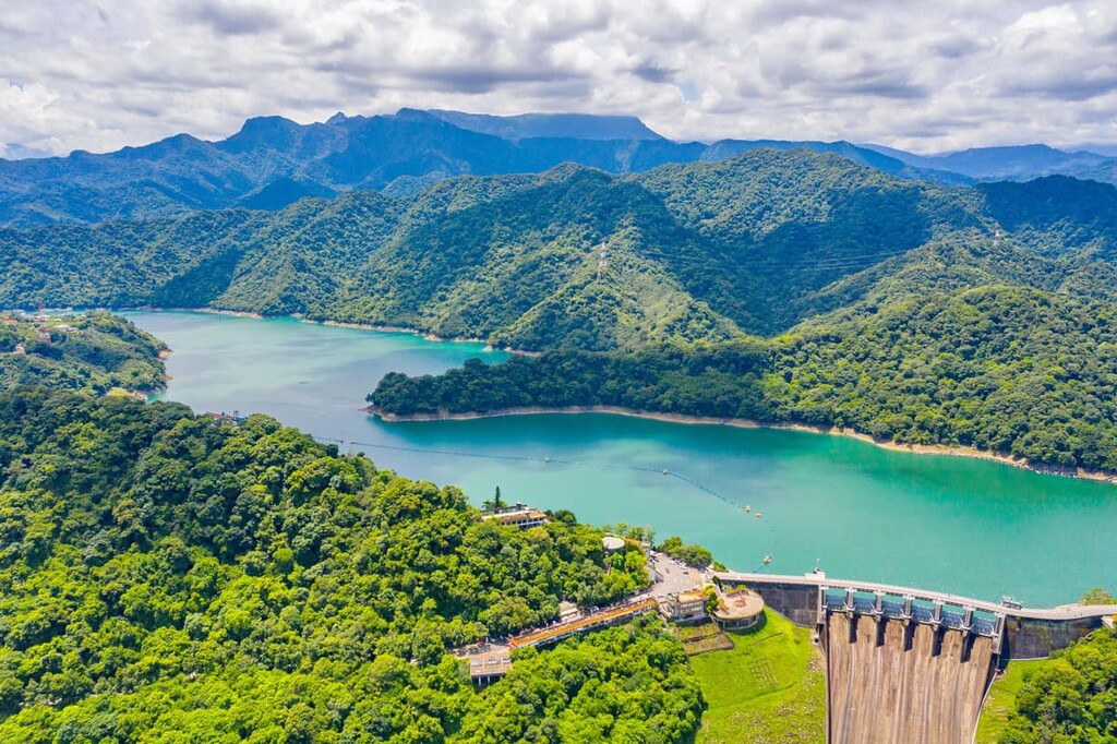
Furthermore, the city contains one of the largest reservoirs in Taiwan, Shihmen Reservoir, which is a popular destination for locals and tourists because of the picturesque setting of the vast turquoise lake against the backdrop of hilly peaks. Spring is an attractive time to visit Shihmen Reservoir for the alluring blooming of plum blossoms, cherry blossoms, peach blossoms, and azaleas.
Daxi District in Taoyuan City is known as a 'presidential town' as both of the former presidents of Taiwan, Chiang Kai-shek and Chiang Ching-kuo, were residents of this area. Daxi Old Street is a drawcard for tourists due to its Baroque-styled architecture in its historic old town.
Longtan Lake was once an irrigation pond, but since the majestic Nantan Temple was built on the inner island in the lake, it has since become a popular tourist attraction in Taoyuan City. It is an exceptionally captivating spot at night when the fluorescent lights of Chung-Yi Bridge leading towards the temple reflect off the lake's still waters.
The electrifying yet laid-back capital city of Taiwan is an exciting place to discover for first-time and returning visitors to the island. One is spoilt with incredible sightseeing opportunities and activities due to the many countless attractions Taipei offers.
The lotus-shaped 101-story building, Taipei 101, is a fascinating skyscraper that can be viewed in most areas of the city. Taipei 101 was the tallest building on Earth from its completion in 2004 until 2009 when Burj Khalifa in Dubai bested it for the world record. It is, however, the tallest building in the world to receive LEED Platinum status, which means that it is an energy-efficient building
The famous Shilin Night Market is an absolute must-visit when touring the city of Taipei. The streets are lined with charming food vendors selling delightful snacks and obscure delicacies. The wander through the market alone is intriguing enough, with a mixture of titillating smells drifting through the street with exotic foods openly displayed at the limitless food stalls.

For a historical viewpoint of Taipei, a trip to the stately National Palace Museum, the grand National Chiang Kai-shek Memorial Hall, and the captivatingly beautiful Longshan Temple will enthral and educate tourists on history, culture, and religion in Taiwan.
It is recommended to drive to Chatianshan Nature Reserve due to the limited public transport options in the region. However, if visitors have no other option, getting to Chatianshan Nature Reserve via public transport is possible.
Coming from the major cities of Taipei, Hsinchu, Taichung, Tainan, and Kaohsiung, take the Taiwan High Speed Rail (HSR) or the express train (TRA) to Taoyuan. Visitors arriving from the Taoyuan HSR Station need to make their way to the Taoyuan TRA Station via the THSR Shuttle Bus. Once at Taoyuan TRA Station, visitors board the Taoyuan bus 5090 to Lalashan Entrance.
Alternatively, visitors can rent a car or scooter and drive to Chatianshan Nature Reserve. It is a 39 km (24 mi) drive from Taoyuan City and a 63 km (39 mi) journey from Taipei.