
Scan the QR code and open PeakVisor on your phone
Nan’ao Broadleaf Forest Nature Reserve has 1 named peak. The highest is Yuenshan at 1,240 m.
The Nan’ao Broadleaf Forest Nature Reserve (南澳闊葉樹林自然保留區) of northern Taiwan encompasses the pristine Mystic Lake (神秘湖). There is only 1 named peak in the reserve, the highest and most prominent of which is Yuen Shan (御恩山) at 1,240 meters (4,068 ft) in elevation.
The Nan’ao Broadleaf Forest Nature Reserve is situated in Nan’ao Township (南澳鄉) of Yilan County (宜蘭縣). The entire area covers 200 ha (494 acres) of land.
Rich and rare wildlife and plant life thrive in Nan’ao’s lush woodlands. A flourishing plant community of the willow trees (Salix mesnyi) and Jiuxiong trees can be found throughout the lower and mid-elevations of the forest.
Additionally, an array of aquatic plants flourish in the 5 hectare (12 acre) Mystic Lake, which lies at an elevation of 1,100 meters (3,609 ft).
As the forest lies close to the coast of Yilan, the hills surrounding the reserve are relatively gentle and they provide minimal protection against the torrential northeast monsoon and destructive typhoons of summer. Therefore, the average rainfall is exceedingly high at 5,000 mm (197 in) per year.
Despite the reserve’s relatively low elevation, cloud cover is prevalent in Nan’ao. For this reason, temperatures do not exceed 22°C (72°F) in the height of summer, while the humidity stops the forest from dropping below a chilly 8°C (46°F) in winter. Thus, Nan’ao forest has an annual average temperature of around 15°C (59°F).
While no rivers flow directly through Nan’ao Broadleaf Forest Nature Reserve, the area lies between the Nan River (南溪) in the north and the Ping Stream (平溪) in the south. Mystic Lake’s waters flow southward toward Aohuaxi Waterfall (澳花瀑布) before they reach the Ping River.
Many areas of untouched beauty surround Nan’ao Broadleaf Forest Nature Reserve. Taiwan’s natural gem, Taroko National Park (太魯閣國家公園), lies to the south, while the pristine beech woodlands of Taipingshan National Forest Recreation Area (太平山國家森林遊樂區) are located to the west.
The Pacific Ocean’s expansive cobalt seas lie to the east of the reserve, too. Furthermore, the geological wonder of the Northeast Coastal Reserve (東北角沿海保護區) is located to the north of Nan’ao.
Nan’ao’s sole peak, Yuen Shan, is the easternmost extension of the Nanhu Dashan (南湖大山) massif, which is one of Taiwan’s 100 peaks. Nanhu Dashan and Yuen Shan are both part of Taiwan’s longest chain of peaks, the Central Mountain Range (中央山脈).
As Nan’ao’s forest lies where the Eurasian and Philippine Sea plates collided, the region boasts extensive evidence of the folding and faulting that has happened over the last tens of millions of years. Additionally, the rocks in Nan’ao are among the oldest in Taiwan.
Yuen Shan’s rock strata consist primarily of schist that dates back to the Palaeozoic through Mesozoic. Siliceous schist, greenschist, and black schist interlace and intertwine in Yuen Shan.
The forests of Nan’ao Broadleaf Forest Nature Reserve primarily consists of verdant hardwoods, such as Formosana alder, Jiuxiong (Lagerstroemia subcostata), Chinese cedar, and stone oak.
Nan’ao forest consists primarily of terrestrial plants, though there are also a number of aquatic plants that live in Mystic Lake’s waters. Hornwort, East Asian black triangle (Sparganium fallax), and water hair flower (Schoenoplectus mucronatus subsp. robustus) all grow in the lake.
Nan’ao’s leafy landscape also creates a perfect habitat for wildlife. Formosan rock macaques, Taiwan moles, and red-bellied squirrels are just 3 of the 12 mammals living in the nature reserve. Bird species found in the reserve include Mandarin duck, pelican, and night heron.

Nan’ao Township has a long and extensive history of human habitation. Archeologists believe that human activity in the region began around 6000 BCE. One archeological site, the Hanben ruins, showcases tombs and residences of the region that date back to the Metal Age, around 1,800 years ago.
Around 200 years ago, the Atayal walked the Nan’ao Historic Trail daily to find sustenance for their families. Nan’ao Historic Trail was once an old hunting passage for the Atayal people who have lived in Nan’ao’s forests for countless generations. During the Japanese Occupation Era, the Japanese used the road as part of their broader surveillance system to oversee and oppress the Atayal and other Indigenous communities in Taiwan.
Nan’ao Township is also home to its own Treasure Island, which is situated off Yilan’s coast. Wu Ping, a Ming dynasty pirate, is believed to have buried his stolen treasure in the sands of one of Nan’ao’s small islands. After the death of Wu Ping, the secret location of his hidden jewels died with him. To date, no one has yet found Wu Ping’s infamous bounty.

Visitors to Nan’ao Broadleaf Forest Nature Reserve, have many excellent hiking options available for exploring the reserve’s fertile forests and the charming attractions. Here’s a look at some of the major hiking trails and areas that are found in and around Nan’ao.
For a peaceful stroll in nature that also lets you admire the extensive history of the area, you can set out on the 3 km (1.8 mi) densely forested Nan’ao Historic Trail. The trail has an elevation range of 250 to 350 meters (820 to 1,148 ft), so it will let you journey through Nan’ao’s plethora of rampant broadleaf trees.
Along this trail, Taiwan longan, sweetgum, and sandalwood are the primary low-elevation trees. You’ll also find green ramie, black maidenhair fern, and foxtail fern along the forest floor on the Nan’ao Historic Trail.
While wandering this historic trail, you will witness old ruins from the past. After completing the first 750 meters (2,460 ft) of the trail, you’ll see an old suspension bridge that hangs above the Nan River. Thankfully, a much newer and sturdier suspension bridge now spans the Nan River.
After you cross the bridge, the Nan’ao Historic Trail dips to the Nan River’s edge, where giant boulders shoulder the turquoise stream. The clear waters of the river unveil the aquatic life of freshwater fish and shrimp.
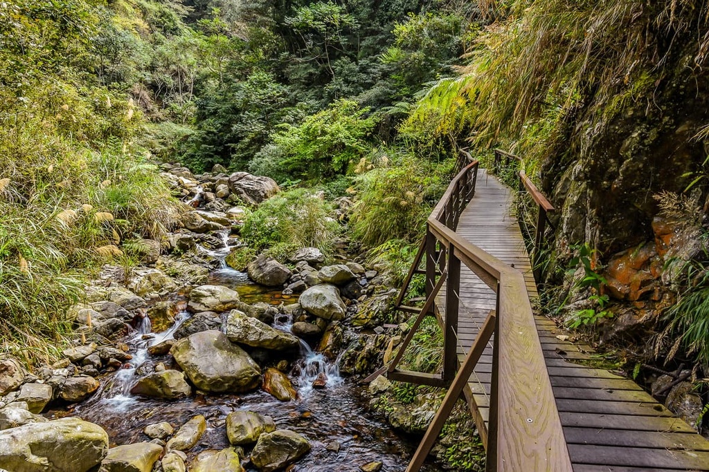
While the Nan’ao Historic Trail traces the lower elevations of Nan’ao Broadleaf Forest Nature Reserve, the Yuen Shan Hiking Trail explores higher ground. This 6.5 km (4 mi) long trail traverses the middle elevation woodlands of the reserve, and it leads to Mystic Lake before taking you to the summit of Yuen Shan.
Mystic Lake is aptly named after the prevailing cloud cover that shrouds the lake with an enchanting mist. A flourishing chrysanthemum forest encircles the Mystic Lake, adding to the area’s beautiful scenery.
The idyllic setting of Mystic Lake and its remote location on Yuen Shan allow you to take a moment to appreciate the pristine scenery that lies before you. The quietness of the lake is only interrupted by merry birdsong and the chirping of insects.
Getting to Yuen Shan requires trekking a bit further from the lake; however, you cannot enjoy any views from its overgrown summit. However, the Yuen Shan Hiking Trail’s journey is not about scaling mountains, but about admiring Nan’ao’s wondrous and beautiful scenery.
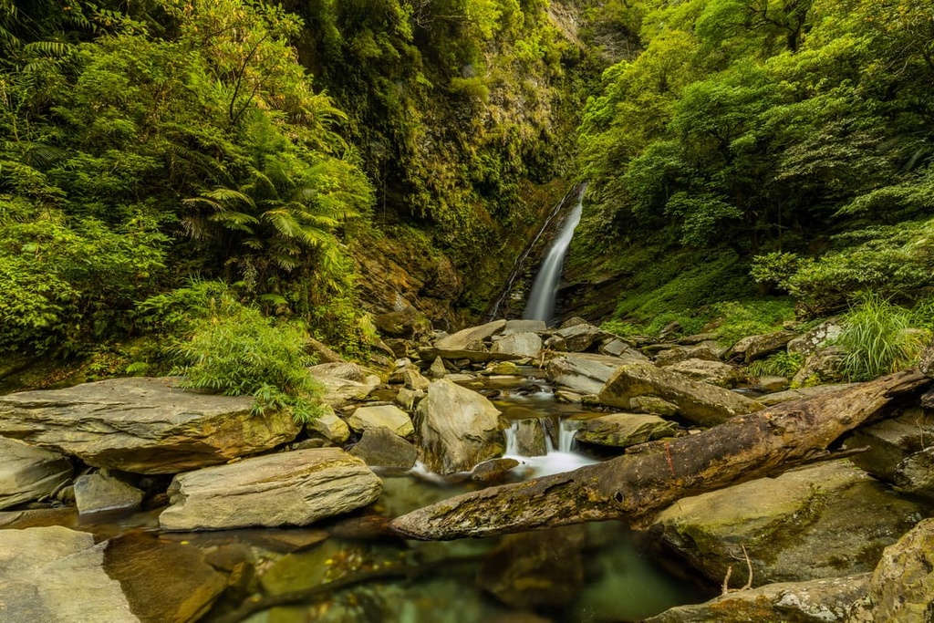
To the north of Nan’ao Broadleaf Forest Nature Reserve is the alluring beauty of Jinyue Waterfall (金岳瀑布). This path to the falls is only 200 meters (656 ft) long, making it an enjoyable journey for people of all ages and endurance levels.
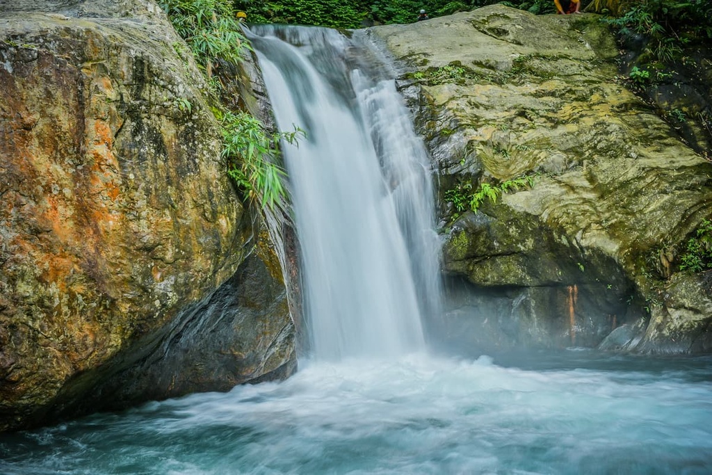
The 30-meter-high (98 ft) waterfall is composed of seven layers. Thus, instead of one intensely flowing rapid, there are several smaller falls arranged like a giant staircase. If you are feeling brave, you can trace the waterfall’s edge, and climb to the top of the falls, but this is a potentially dangerous part of the trek that’s not appropriate for everyone.
That said, the second layer of Jinyue Waterfall is popular with visitors who slide down the 5-meter (16 ft) chute. At the end, the waters of Jinyue Waterfall collect in an emerald pool at the base of the falls.
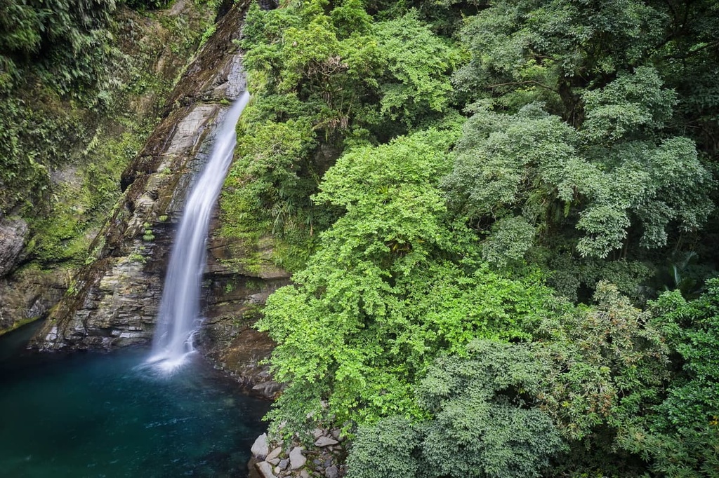
Nan’ao Broadleaf Forest is blessed with another beguiling waterfall that’s situated to the south near the border of Yilan and Hualien County (花蓮縣). A short 300 meter (984 ft) paved course of dense Jiuxiong trees lies before the spectacular 47-meter (154 ft) Aohua Waterfall.
Unlike Jinyue Waterfall, Aohua Waterfall is one lengthy drop rather than a multi-tiered cascade. On this trail, you will hear the mighty crashing rapids before setting sight on the majestic scene. The trail is shaded by an abundance of flora of ferns, snakeroot, and hydrangeas, all of which allow for a truly magical forest scenery on your hike.
You can link the journey to Aohua Waterfall to the Aohua Village. Three of Taiwan’s Indigenous tribes, the Truku, Sediq, and Atayal, coexist in Aohua Village, a melting pot of culture and history. The village may be small, but it is home to a plethora of shops that offer many local delicacies for visitors to enjoy.
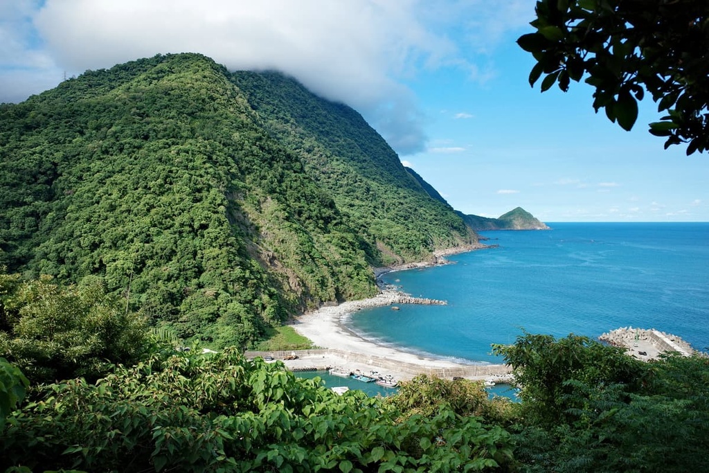
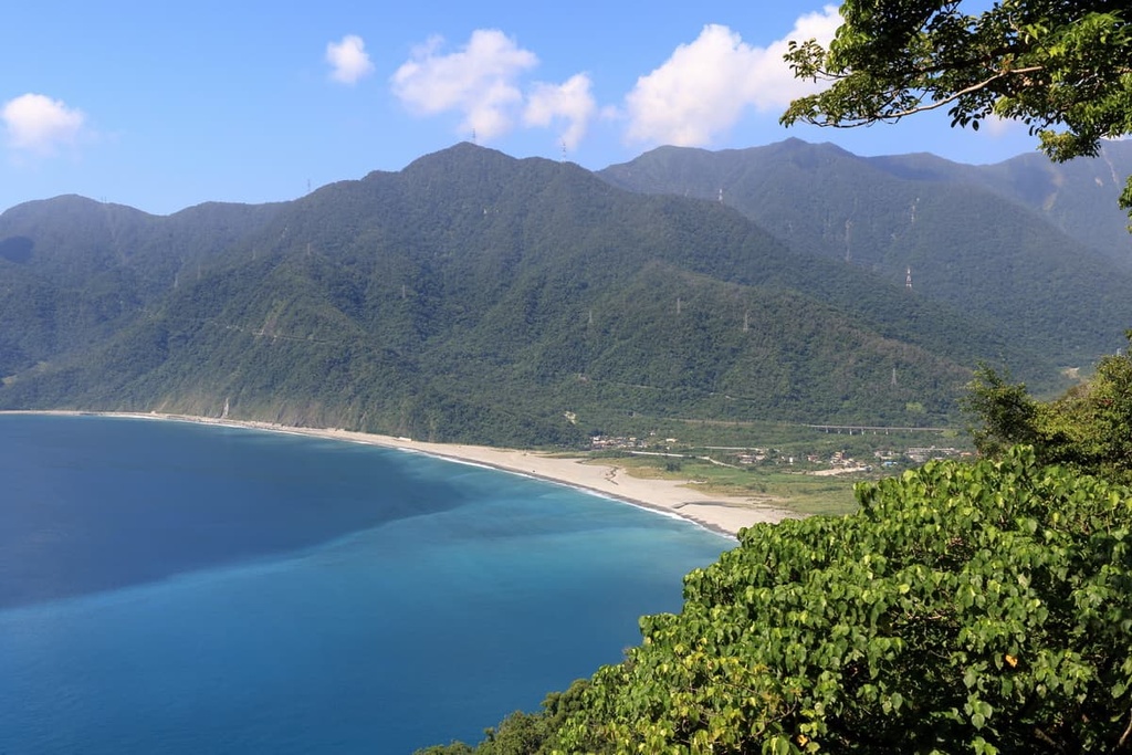
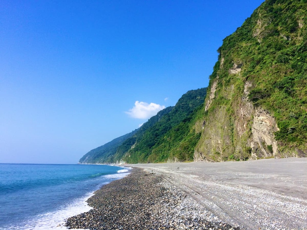
If you want to get closer to the ocean, you can walk the 7 km (4.3 mi) long Nan’ao Beach Trail, which walks along the gray pebble-stoned Nan’ao Beach. The trail features the rhythmic crashes of the Pacific Ocean’s waves to one side and steep rocky cliffs coated in shrubbery on the other side.
The scenery around the trail features extensive evidence of weathering and erosion at the hands of the Pacific Ocean. Along the trail, there is further evidence of the erosive power of the ocean’s waves, namely a collection of rocky caves. However, the caves themselves are only accessible at low tide.
Yilan City (宜蘭市) and Hualien City (花莲市) are the most convenient cities to stay in when visiting Nan’ao Broadleaf Forest Nature Reserve. These two nearby cities are renowned for their bustling urban centers and their proximity to nearby nature reserves. Here’s what you know before your next visit.
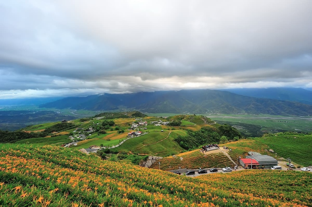
Located to the south of Taiwan’s capital, Taipei (臺北市), is the calm and serene Yilan City. Since Yilan is situated a short drive from Taipei, many use it as a weekend nature escape from the hustle and bustle of city life. Indeed, Yilan features a variety of luscious nature parks and reserves where peace and tranquility linger through the misty, leafy air.
One such park is Taipingshan National Forest Recreation Area. The recreation area features dense woodlands of Taiwan beech and Taiwan hinoki. There are countless trails to hike in the recreation area, one of which leads to Cueifong Lake (翠峰湖), Taiwan's largest alpine water body. Taipingshan forest is a prime spot to view spring's onset, namely, the highly anticipated bloom of the region’s pastel pink cherry blossoms.
Another one of Yilan's pristine areas of natural beauty is Qilan Wildlife Reserve (棲蘭野生動物重要棲息環境). Qilan is most well-known for its collection of ancient, giant trees. Qilan Divine Tree Garden is home to 51 Taiwan cypress and red cypress trees that have reached divine status, which means that they are over 1,000 years old. One cypress tree in the grove is actually older than Confucius at 2,650 years in age.

For a refreshing experience after hiking in Yilan's emerald woodlands, check out Su'ao Cold Springs. Situated a close walk from the Su'ao Train Station, Su'ao Cold Springs is located on a hillside and it features an open-air pool with supreme views of the Pacific Ocean. As the spring's temperature is lower than your body's at 22°C (72°F), you will first feel cold upon entering the carbon dioxide–infused waters. However, the carbonated waters of the spring are believed to create radiant skin, so people use it as a beautifying bath.
While in Su'ao, you can head to one of Yilan's highly-rated beaches, most of which are popular surfing spots. The sandy Neipi Beach is a perfect place to visit if you want to dip into the inviting aquamarine waves or take a casual stroll down the sandy bay. To admire the glorious coastal scene of Neipi Beach, make a trip to the coast during sunrise or sunset to see the region’s gorgeous amber-hued skies.
Another option to consider when visiting Yilan is a trip to Gueishan Island (龜山島), which is situated just off the coast of Yilan City. Its name translates to 'turtle mountain,' which makes sense as Gueishan Island is shaped like a turtle. You can catch a ferry to this pocket of pristine paradise where dolphins and whales playfully roam around the islet's waters, and crabs scuttle along the sandy shores.
Further to the south of Yilan City is Hualien City, the pearl of east Taiwan. Due to the limited rail network linking the highly accessible west coast to the remote east coast, eastern Taiwan receives fewer visitors than its western counterpart. However, those undertaking the long journey to this outlying region are rewarded with the exquisite beauty of the road less traveled.
One of Hualien’s and Taiwan’s finest attractions, Taroko National Park has it all: high peaks, challenging hiking trails, marble cliffs, flourishing flora, and a narrow and steep gorge. Many shorter routes line the patterned rock canyon where the glistening sapphire Liwu River gently winds its course throughout the park’s pristine valley.
For hikers wishing to ascend one of Taiwan’s 100 peaks, Hehuanshan (合歡山) is a great option as its 1.8 km (1.1 mi) trail makes for a relatively easy trek. There are countless more lengthy and complex trails in Taroko National Park if you want to test your endurance.
Alternatively, Liyu Lake is a popular weekend destination for those wishing to immerse themselves in the quietness of nature. The lake itself is surprisingly large and Taroko National Park’s nearby peaks reflect on its glistening surface. You can enjoy a number of outdoor activities at the lake, such as camping, cycling, boating, and even paragliding.
Another idyllic setting in Hualien is the Wuhe Tea Plantations. Here, you can admire Wuhe’s emerald tea fields and also sample the wide variety of teas grown in the area. One of its famous brews is the Honey Peach Black Tea, a gold medal recipient in the First World Tea Award of 2006.
Of, if you’re looking to go forest bathing, the verdant woodlands of Fuyuan National Forest Recreation Area (富源國家森林遊樂區) are a must-visit. You can get lost in this large camphor forest, where phytoncide is released in abundance. In Fuyuan’s Butterfly Valley, you can soak in the thermal outdoor spa while butterflies flutter about.
To admire Fuyuan’s remote setting, the view from the Longyin Suspension Bridge showcases the fertile forested valley. At the same time, the cascading Longyin Waterfall glides its foamy rapids down a 30 meter (98 ft) cliff.
Finally, another one of Hualien’s top scenic attractions is the Huadong Coastal Reserve (花東沿海保護區). This coastal drive runs fro 180 km (112 mi) along eastern Taiwan between Hualien and Taitung (台東市). Numerous geological rock features dot roadside while the gentle hills of the Hai’an Range (海岸山脈) can be seen in the distance. Known as one of Taiwan’s most scenic drives, the Huadong Coastal Reserve journey is an excellent option for anyone who wants to venture further down Taiwan’s remote east coast.
To get to Nan’ao Broadleaf Forest Nature Reserve, you need to make your way to Yilan City. You can take the local express train (TRA) from Taiwan’s major cities to get to Yilan.
As there are relatively few public transport routes that can take you to Nan’ao, the best option is to rent a car or scooter. You can then make the 63 km (39 mi) journey from Yilan City to Nan’ao Broadleaf Forest Nature Reserve.


The highest peak in Nan’ao Broadleaf Forest Nature Reserve is Yuenshan, at 1,240 m.
Notable peaks in Nan’ao Broadleaf Forest Nature Reserve include Yuenshan.


