
Scan the QR code and open PeakVisor on your phone
Located along the Sunshine Coast of British Columbia, Canada, Inland Lake Provincial Park is an accessible park with camping sites, hiking trails, a beautiful lake that is great for boating, swimming, and fishing. Mount Mahony is the only mountain in the park, and it rises 1,087 m (3,566 ft) above sea level and overlooks Inland Lake.
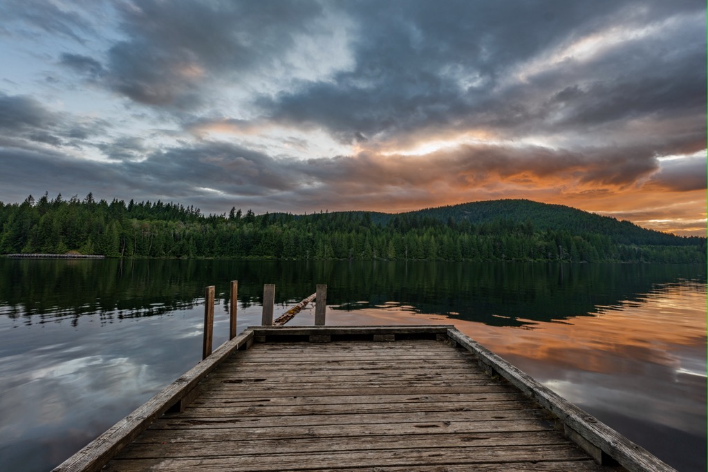
Inland Lake Provincial Park is located along the coast of British Columbia, Canada, in the qathet Regional District. The park encompasses Inland Lake, Confederation Lake, and borders part of Powell Lake. Mount Mahony rises from the eastern shore of Inland Lake to an elevation of 1,087 m (3,566 ft).
The area was originally established as the Confederation/Haslam Lake Protected Area in 1977 and the campsites were part of a Forest Service Recreation Area. The park was established in 1997 and BC Parks works in partnership with the Model Community Project for People with Disabilities.
Under the shared stewardship with the Model Community Project, a 13 km (7.8 mi) wheelchair accessible trail was constructed around Inland Lake. Furthermore, attempts have been made to make the rest of the park and the camping facilities as inclusive and accessible as possible.
The park is north of the community of Powell River and is accessed by following forest service roads north of Cranberry Lake. The park is one of many parks in the region that were established as recreation and wilderness conservation sites. The following are some of the other nearby parks and wilderness areas:

The Coast Mountains dominate the landscape around Inland Lake Provincial Park and they are known for their steep slopes, rugged topography, and sharp peaks. The major underlying rock of the park is granodiorite, which is a type of intrusive igneous rock.
The granodiorite formed between 160 and 100 million years ago through the slow cooling of magma beneath the earth’s surface. The rock typically has a light color, coarse texture, and high silica content. Indeed, the granodiorite of Inland Lake Provincial Park is part of the greater Coast Plutonic Complex.
The Coast Plutonic Complex is a massive batholith that extends from Alaska through British Columbia and essentially forms the backbone of the Canadian Coast Mountains. The intrusions of magma occurred when the Kula tectonic plate subducted beneath the North American plate which created weaknesses in the Earth’s crust.
While volcanoes did also occur at this time, the Plutonic Coast Complex and batholiths are created when magma rises along fault lines and other crustal weaknesses into the existing crust but doesn’t make it to the surface.
Since the magma didn’t reach the surface, it cools slowly and the slower it cools, the denser the resulting rock is. Granodiorite is a granite-like rock, with the differences being that granodiorite has a different feldspar present and has more dark iron and magnesium than granite.
Furthermore, the heat of the magma intrusions caused metamorphosis in the surrounding rock bed. As such, while granodiorite is the major underlying rock, rockhounds in the region will still find many examples of both metamorphosed and unaltered sedimentary and igneous rocks.
Following the creation of the mountains and the Coast Mountain Complex, during the Pleistocene, glaciers formed among the peaks and carved out valleys as they moved towards the coast. At the time of the glacial maximums, Inland Lake Provincial Park was likely covered with over a kilometer of ice.
Indeed, Inland Lake Provincial Park borders upon Powell Lake which was created by the massive glaciers that flowed down from the Coast Mountains. An interesting fact about Powell Lake is that the bottom of the lake is filled with 10,000-year-old water from the ocean.

Glaciers initially carved a massive U-shaped valley that was once filled with saltwater from the ocean when the sea level was relatively higher and there was a fjord that was connected to the ocean. As the Pleistocene ended and the ice sheet and glaciers receded, the continent was subjected to isostatic rebound which raised the continent up and lowered the relative sea level.
As the sea level lowered, the fjord was cut off from the ocean and freshwater began to displace the salt water in the new lake. Due to the topography and the depth of the lake, it became meromictic, which means it has a layer of fresh water upon the denser salt water.
The fresh water of the lake extends down about 100 m (328 ft), and the bottom is filled with ancient salt water. Indeed, Powell Lake is incredibly deep, measuring about 360 m (1,180 ft) deep at its deepest.
Inland Lake Provincial Park has a variety of habitats that support various flora and fauna; however, the temperate rainforest is predominant. The park is home to the riparian areas along the shores of Powell Lake, Inland Lake, and Confederation Lake, as well as subalpine forests and alpine meadows upon the slopes of Mount Mahony.
The coastal rainforest of the park is characterized by tall trees, dense underbrush, and a moist, humid environment. Red cedar is likely the easiest tree to identify in the park and there is also western hemlock, Douglas fir, Sitka Spruce, alder, and big leaf maple. These forests are typically inhabited by black bears, cougars, deer, and elk, all of which you may encounter while visiting the park.
Most of the forests around Inland Lake have been logged at some point in recent history, except for an area of old growth around Confederation Lake. Old growth forests are especially vital to the health of the coastal ecosystem as they support a diversity of life, including mosses, liverworts, and many bird species which are better adapted to the ancient forests.
The shores of central British Columbia have been inhabited for thousands of years and Inland Lake Provincial Park is in the traditional territory of the Tla’amin Nation, also known as the Sliammon. Indeed, the waters and wilderness areas of the park have been used by the indigenous of the region for generations.
Near the park there are archeological sites that contain the remains of habitations that were constructed over 8,000 years ago. The Sliammon are a Coast Salish people, and they have a long tradition of hunting, fishing, and boat building.
The Sliammon were known for their expertise in canoe-building, and their dugout canoes were used for transportation, fishing, and hunting. Furthermore, the Sliammon had a deep knowledge of the local flora and fauna, and they used the plants and animals of the park for food, medicine, and spiritual purposes. Village elders were an important aspect of maintaining and passing along the collective knowledge and history.
When European settlers arrived in the area in the late 1800s, there were significant changes. Drawn by the natural resources of the area, including timber, minerals, and fish, the traditional lifestyle of the Sliammon was disrupted. Furthermore, the European traders and settlers brought diseases such as smallpox, which devastated the indigenous population.
Logging and mining operations opened up across the park. Except for an area around Confederation Lake, the ancient forests were harvested. However, despite the intense exploitation of the land, the natural beauty of the park was recognized by some early visitors, who saw the potential for tourism and recreation.
In the 1920s, outdoor enthusiasts established the Powell River Parks Association which advocated for the creation of protected areas in the region. Campsites were established originally as part of a Forest Service Recreation Site and the land was preserved as part of the Confederation/Haslam Lake Protected Area.
In 1977, the land was turned over to BC Parks to establish Inland Lake Provincial Park. Further involvement by the Model Community Project helped make the park accessible to those with limited mobility and other disabilities.

There are many activities to enjoy at Inland Lake Provincial Park, such as hiking, swimming, paddling, fishing, wildlife viewing, cycling, hunting, and camping. The park has many wonderful camping areas and the vehicle accessible camping areas have been designed to make them more accessible.
While many may enjoy fishing, paddling, or swimming, there are also a couple of hiking trails in the park. The Inland Lake Trail is a 13 km (7.8 mi) wheelchair accessible trail around Inland Lake. This trail is great for families and cyclists too. The trail offers stunning views of the lake and surrounding mountains and truly showcases the park’s natural beauty.
In addition to the lake loop and several shorter trails, there is a trail to the summit of Mount Mahony. The trailhead is near the south end of Inland Lake, and it follows old logging roads to the summit of the mountain. It is about 11 km (6.6 mi) to the peak, and along the way hikers get to enjoy the seclusion of the wilderness and views of the surrounding area and down upon the lake.
Even though Inland Lake Provincial Park is part of the mainland of British Columbia, the qathet Regional District is relatively remote and visitors to the park and area must take a ferry, personal boat, or plane. The following are the major communities in and around the region and park.
The city of Powell River is the regional capital and the largest community near Inland Lake Provincial Park. Inland Lake Provincial Park is about 12 km (7.2 mi) from the city and provides a wonderful place for residents to enjoy for an afternoon or a weekend.
Powell River is situated upon the shores of the Malaspina Strait, and the community was a major stopover for prospectors and miners heading inland during the 1800s gold rushes. During the Fraser Gold Rush in the 1800s, gold prospectors would ferry over to Powell River from Victoria, where they could acquire mining permits.

The deep, glacier-created fjords which are common along the west coast of Canada have prevented a road from being constructed to the community. Once you make it to Powell River, there are many beautiful wilderness parks and hiking trails to check out.
Inland Lake Provincial Park is certainly the closest wilderness area, and it is a beautiful destination while visiting Powell River. Those seeking grander adventures; however, may prefer exploring the Sunshine Coast Trail.
The Sunshine Coast Trail is a 180 km (108 mi) backcountry trail along the coast of British Columbia. The trail is free to access, and it winds through old growth forests, along lake shores, and along beaches for all to enjoy. The Confederation Lake Trail in Inland Lake Provincial Park is part of the Sunshine Coast Trail.
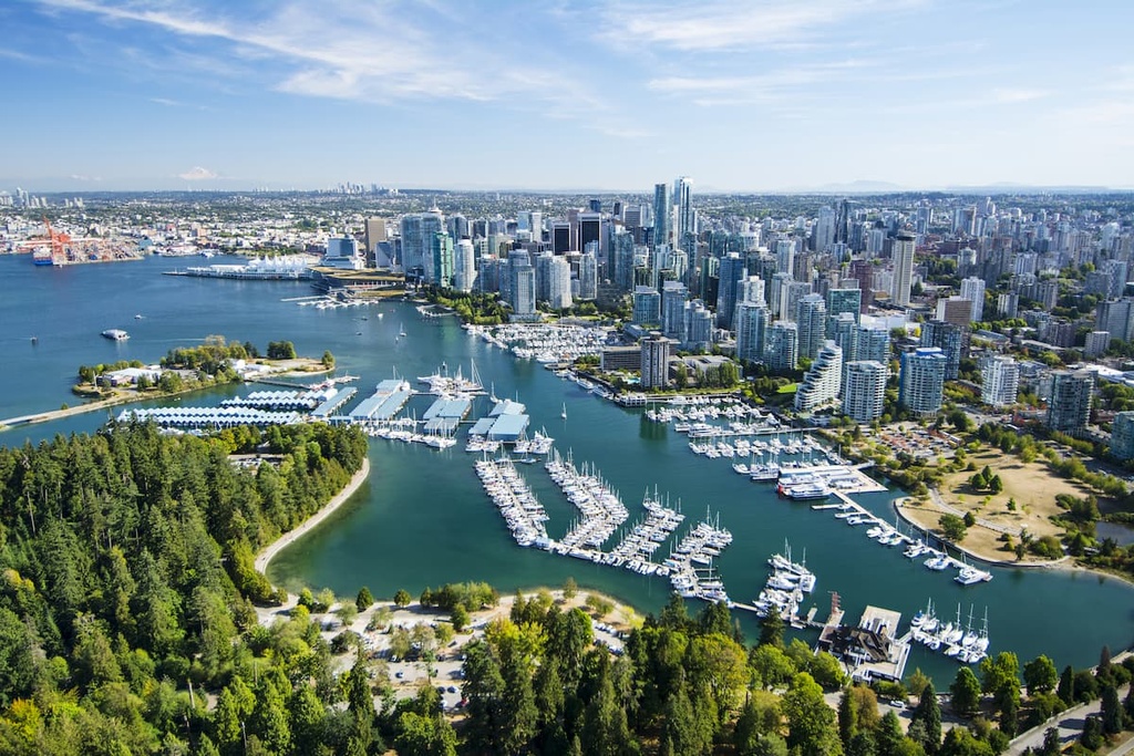
Vancouver is a major city that’s located 180 km (108 mi) south of Inland Lake Provincial Park and it is a beautiful drive along the coast between the two places. The city of Vancouver is the namesake of the Vancouver Metropolitan Area, and the area is often referred to as the Lower Mainland.
Vancouver has many cultural attractions and nearby wilderness areas. While in Vancouver, visitors can visit libraries and museums, view performing arts and art galleries, and enjoy a vibrant nightlife. While out for the day visitors can also visit Stanley Park, which is one of North America’s largest urban parks.
Other hikes and walks near and in the city are trails to St. Marks Summit and Quarry Rock, and the Grouse Grind is a popular test of stamina. Just outside of the metropolitan area visitors will find wonderful hiking trails in Mount Seymour Provincial Park, Garibaldi Provincial Park, Golden Ears Provincial Parks, and Pinecone Burke Provincial Park.


