Scan the QR code and open PeakVisor on your phone
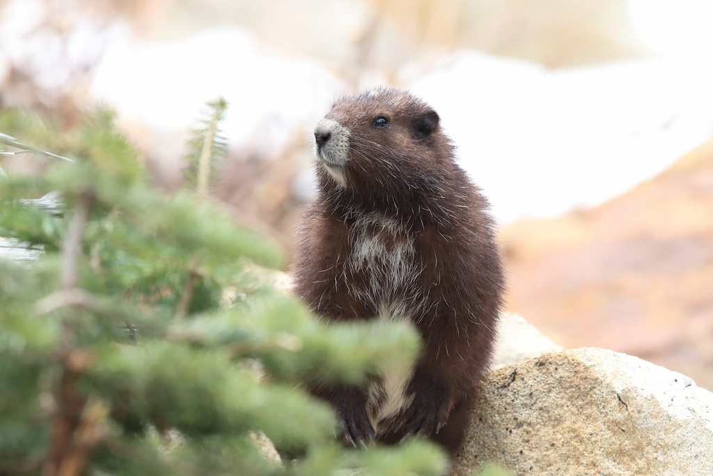
Vancouver Island in British Columbia, Canada is home to beautiful lakes, rivers, mountains, forests, and coastlines. Haley Lake Ecological Reserve is located on the upper slopes of Gemini Mountain and Butler Peak on the island and it was created to preserve the core habitat of the endangered Vancouver Island marmot.
The Haley Lake Ecological Reserve is part of the Regional District of Nanaimo in British Columbia, Canada. The reserve includes the area around Haley Lake and the summit areas of Gemini Mountain and Butler Peak, which have elevations of 1,516 m (4,974 ft) and 1,440 m (4,724 ft), respectively.
British Columbia’s ecological reserves were created to preserve a collection of special natural ecosystems, animals and plant species, and rare natural phenomena and natural features. In particular, Haley Lake Ecological Reserve was established in order to preserve the core habitat of the endangered Vancouver Island marmot (Marmota vancouverensis).
Ecological reserves are created for the preservation of specific conservation and scientific purposes and not for outdoor recreation. Typically, ecological reserves are open to the public for non-destructive and non-consumptive pursuits such as hiking, nature observation, and photography.
However, Haley Lake Ecological Reserve restricts access to the reserve to protect the marmots and their habitat from any interference. Indeed, while logging roads run adjacent to the ecological reserve, permission must be obtained from BC Parks, the land owner, and the area water authority to access the park, roads, and the area in general.
The Haley Lake Ecological Reserve covers the alpine areas of Gemini Mountain and Butler Peak, both of which are part of the Vancouver Island Ranges. The Vancouver Island Ranges feature rock that is part of an exotic terrane called Wrangellia.
Wrangellia started forming 380 million years ago as a result of undersea lava deposits that were followed by a period of sediment accumulation and a final volcanic burst that lasted five million years. The final addition to Wrangellia created the major 6 km (3.6 mi) thick layer of basaltic lava that can currently be found in most of the mountains on Vancouver Island.
Over 100 million years ago, the Wrangellia terrane began to collide with the west coast of North America. As the oceanic tectonic plate that Wrangellia was formed upon was subducted beneath the North American plate, Wrangellia was scraped from the plate and stuck, or accreted, to the mainland.
Parts of Wrangellia buckled to form mountains while other parts crumbled and eroded. Wrangellia terranes make up part of southeast Alaska, the Queen Charlotte Islands, part of the Coast Mountains, and Vancouver Island.
The mountains that formed on Vancouver Island are the Vancouver Island Ranges. One of the chain’s subranges, the Seymour Range, lies to the south of Cowichan Lake in the Cowichan Valley Regional District.
The rocks of Wrangellia and, therefore, the rocks that form Gemini Mountain and Butler Peak are made from layers of Paleozoic sedimentary and volcanic rocks that were intruded by mafic sills and overlain by successive layers of basalt, limestone, argillites, and tuffaceous sediments.
During the last glacial maximum, as glaciers scoured the landscape of Vancouver Island, Gemini Mountain and Butler Peak would have both been covered by this massive ice sheet. The Fraser Glaciation, which occurred between 29,000 and 15,000 years ago, created most of the current topography of the mountains in the region.
In particular, the glaciers carved deep, wide, U-shaped valleys across the region and left deposits of glacial till. Within the reserve, the effects of the glaciers are seen in the bowl-shaped cirques that were carved from the sides of the mountain.
The rare Vancouver Island Marmot is the reason that the Haley Ecological Reserve was created in the first place. Most of the park is representative of the subalpine Mountain Hemlock ecosystem, though it also contains a fringe of forest that is typical of the Coastal Western Hemlock.
The Vancouver Island marmot is an endangered species that is only found on Vancouver Island. Indeed, the Vancouver Island marmot is the only endemic species in Canada that is listed as endangered. As of 2008, it is believed that there are less than 100 individual marmots left in the wild with an additional 162 in four captive breeding sites.
It is also believed that about half of all the Vancouver Island marmots inhabit the Nanaimo-Cowichan Lake area while the core population lives in and around the Haley Lake Ecological Reserve. The reserve is dominated by subalpine forests that are filled with mountain hemlock, amabilis fir, and yellow cedar.
The lower slopes of the forest are covered with western redcedar, western hemlock, amabilis fir, Sitka spruce, Douglas fir, and big leaf maple. The forests surrounding the reserve are being logged for their commercial-grade timber. While this logging is economically important, it also further isolates the different populations of marmots.
The Quw’utsun First Nation and their ancestors have long lived in the area that is now called the Cowichan Valley, including the area that is now part of the Haley Lake Ecological Reserve.
While there is no archeological evidence that First Nations inhabited the Haley Lake Ecological Reserve, there is clear archeological evidence in nearby locations such as Clayoquot Plateau Provincial Park that many First Nations in the region historically hunted marmots.
The nearby Clayoquot Plateau Provincial Park has several karst caves where archeologists have uncovered the remains of marmots that were hunted on the plateau. Such finds have led to speculation that similar hunting likely occurred upon Gemini Mountain and Butler Peak; however, there are no obvious caves or natural features that would have facilitated continuous use.
The Quw’utsun are a people of the Coast Salish culture, which has flourished along the southern coast of Vancouver Island and parts of the coastal mainland for centuries. Some of the archeological and cultural sites located around Haley Lake Ecological Reserve include several midden heaps, fishing weirs, and the occasional outline of an ancient village.
Many of the First Nations of this region traditionally followed a seasonal movement pattern around the region to take advantage of the island’s abundant resources. For example, some communities would move between coastal residences for harvesting from the ocean and to the rivers and streams to harvest salmon during their annual run.
Fishing for salmon and harvesting from the beaches and ocean was the primary food sources for the Quw’utsun. However, the Quw’utsun would also hunt deer and marmot to supplement their diet. At the end of the harvesting season, different communities and tribal nations would come together to trade the extra resources they had acquired for resources from other nations.
During the winters, many communities and families would gather in their winter villages in the Cowichan Valley. Longhouses were a common winter residence, and several families would occupy the same house during the winter month.s
Currently, the area surrounding Haley Lake Ecological Reserve is privately owned by logging companies. Agreements were reached in the 1980s that allowed for the establishment of the ecological reserve to preserve the habitat for the endangered Vancouver Island Marmot.
When the reserve was first established, BC Parks sent memos to the local hiking and wilderness clubs to notify them that the area is now restricted, and visitors must request permits to enter into the reserve.
Since the purpose of Haley Lake Ecological Reserve is to preserve the habitat of the Vancouver Island Marmot, there are no established trails in the reserve.
While most ecological reserves in British Columbia are open to public access for activities such as photography, wildlife viewing, and hiking, visitors to Haley Lake Ecological Reserve must first obtain a permit before their adventure.
In addition to obtaining a permit from BC Parks to enter the reserve, visitors must also obtain permission from the forestry companies to use their private roads. You must also get permission from the local water authority to enter the area.
There are many hurdles to overcome to enter the reserve and they are in place for a good reason. While Gemini Mountain and Butler Peak may seem like obtainable peaks to summit and add to your list of peaks that you’ve bagged, it’s always important to think about the unintended consequences of our intrusions into nature and perhaps just admire these peaks from afar.
Some of the other options for hiking areas where you may find marmots are the Forbidden Plateau area of Strathcona Provincial Park, Mount Arrowsmith Massif Regional Park, and Clayoquot Plateau Provincial Park. If you happen to see a marmot while hiking, you are encouraged to report it to BC Parks to aid in the reestablishment efforts of the Vancouver Island marmot that conservationists are working on.
The following are some of the major cities and towns near Haley Lake Ecological Reserve. These cities and towns offer lodging and other services for visitors looking to experience the beautiful mountains and lush wilderness areas of Vancouver Island.
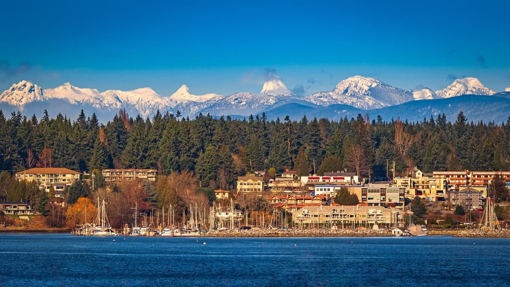
Located about 40 km (24 mi) to the west of Haley Lake Ecological Reserve, Nanaimo is one of the region’s major ferry ports as it receives thousands of passengers a day to Vancouver Island. Originally built as a coal town as people could mine the rich coal seams near the town, Nanaimo has grown to be an industrial, service, and transportation hub for central Vancouver Island.

While visiting Nanaimo, there are many activities and places that you can check out, including many of the heritage sites and buildings around the city. There are also many beautiful coastal and wilderness areas worth visiting near the city. Ammonite Falls, Beach Estates Park, Blueback Beach, Bowen Park, and Buttertubs Marsh are just several of the many areas to venture to during your travels around Nanaimo.
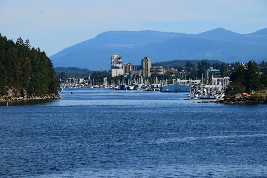
The cities of Courtenay, Comox, and Cumberland are the central municipalities of the Comox Valley and they form the primary commercial and residential area of the valley. The three cities are located about 140 km (84 mi) to the north of Haley Lake Ecological Reserve.
Courtenay and Cumberland grew quickly at the turn of the twentieth century as they were major communities for people who worked in industries such as fishing, mining, and forestry. Comox grew slowly compared to its neighbors as it was historically a vacation town that offered golf, dining, fishing, hunting, tennis, and more to affluent visitors.
With beautiful beaches, clear lakes, rivers full of salmon, and an incredible wilderness just outside of town, tourism has grown significantly in the region. Some of the parks located near the valley that are worth visiting include Seal Bay Nature Park and Helliwell Provincial Park.