
Scan the QR code and open PeakVisor on your phone
Covering the northeastern corner of Alberta, Canada, the Regional Municipality of Wood Buffalo is a remote and stunning area that’s home to many incredible destinations, including the Birch Mountains, the Athabasca Sand Dunes, and Wood Buffalo National Park. Wood Buffalo also contains many geological wonders and cultural sites among its over 60,000 square kilometers (23,000 square miles) of wilderness terrain.
Located among the boreal forests of northeast Alberta, Canada, the Regional Municipality of Wood Buffalo is an administrative district that encompasses over 60,000 square kilometers (23,000 square miles) of terrain and has a population of around 75,000 people.
The regional municipality is bordered by Saskatchewan to the east and the Northwest Territories to the north. Alberta’s Mackenzie County also borders Wood Buffalo to the west while Lac La Biche County, the Municipal District of Opportunity, and the Municipal District of Bonnyville border the regional district to the south.
In 1995, the major city of northern Alberta, Fort McMurray, was amalgamated with Improvement District No. 143. In the process, it was given the status of a specialized municipality, and it’s now called the Regional Municipality of Wood Buffalo. This change was made to address the unique needs of a large urban community that’s surrounded by a huge rural territory with a small population.
Wood Buffalo is known for its unique variety of landscapes and geological features. Some of the most notable features of Wood Buffalo include the Athabasca oil sands, the Birch Mountains, the Athabasca sand dunes, and the ecologically diverse Peace-Athabasca Delta.
The regional municipality is also home to or located adjacent to some of Canada’s important conservation areas, including:
Northeastern Alberta is one of the most geologically interesting areas of the entire province. In particular, the Regional Municipality of Wood Buffalo is home to both significant layers of sedimentary rock and sediment that date back as early as the Paleozoic and early Mesozoic as well as some areas of exposed billion-year-old rocks from the Canadian Shield.
During the formation of the Western Cordillera, which includes the Rocky Mountains, a new Continental Divide was formed that caused the inland sea that once covered northeastern Alberta to start draining to the east and northeast. During this time, new rivers were also created in the region and they eroded away vast amounts of the region’s surface rock in the process.
Several unique geological formations to take note of in Wood Buffalo include the karst topography in Wood Buffalo National Park, the remnants of the Alberta Plateau in Birch Mountains Wildlands Provincial Park, and the oil sands along the Athabasca River.
The karst topography of Wood Buffalo National Park was made possible by the Devonian layers of sediment that comprise the region’s bedrock. This primarily limestone and gypsum-based bedrock was deposited some 400 million years ago.
Karst topography is a type of landform that’s created by the dissolution of soluble rocks like limestone, gypsum, and dolomite. These types of areas typically feature underground drainage systems with sinkholes and caves
The underground drainage of continental waters through the park also created Wood Buffalo’s salt flats. These salt flats were created where saline water that had been traveling underground through permeable limestone was forced to surface as it collided with the impermeable granite of the Canadian Shield. As this saline water reached the surface, it eventually evaporated and deposited its salt onto the ground, creating the salt flats in the process.
The famous oil sands that underlay significant areas of Wood Buffalo were also formed over the course of millions of years as marine creatures lived and died in the shallow sea that once covered Alberta. As these marine organisms died, their bodies accumulated on the seafloor, and they were later covered by further layers of sediment.
As the pressure within the accumulated layers increased, the organic matter turned into oil. Over the subsequent millions of years, that oil became trapped in sand, and as lighter hydrocarbons evaporated or were consumed by bacteria, the thick bitumen and water were left trapped in the sands.
This bitumen was initially used by First Nations to waterproof their canoes. It later became an important source of economic activity when commercial extraction of the tar sands began in the twentieth century. Extraction of the Athabasca oil sands remains a major economic activity (albeit a controversial one) in the region to this day.
The Birch Mountains and the other hills in this part of northeastern Alberta were created as the Alberta Plateau eroded away over the course of millions of years. The topography found in the hills to this day was further carved out during the Pleistocene as alternating glacial and interglacial periods scoured the region.
The ice sheets that originated in the Arctic and in the western mountains of Canada carved out much of what is now Alberta. We can still see evidence of this glacial past in the region today, particularly in the form of features like eskers, drumlins, and moraines.
Wood Buffalo is also home to a number of kimberlite pipes, particularly around the southwestern part of Birch Mountains Wildland Provincial Park. Kimberlite is a type of igneous rock that often contains diamonds, so discovery of the rock can sometimes be an economic boom for a region.
These kimberlite pipes were created by volcanic activity during the late Cretaceous when North America was split by a shallow sea that covered modern-day Alberta.
According to the government of Alberta, more than 50 of these kimberlite pipes have been discovered to date and more than half of them have been found to contain diamonds. It’s unclear if the area will become the site of a major diamond mining operation in the future as more research is needed into the economic viability of these kimberlite pipes.
The Regional Municipality of Wood Buffalo is a vast wilderness of undulating terrain punctuated with hills and lakes. As it is part of the Boreal Forest Natural Region, Wood Buffalo is filled with mixed wood forests and large bogs.
The forests of the region are a mix of lodgepole pine, black spruce, and hybrid lodgepole-jack pine. Forests cover the majority of the municipality, and the rest is covered by shallow lakes, bogs, and rivers.
The northern landscape of Wood Buffalo is home to a diversity of wildlife, including birds, fish, and mammals. White pelicans, bald eagles, loons, terns, cormorants, black-bellied plovers, ruddy turnstones, peregrine falcons, warblers, Franklin gulls, and Bonaparte gulls are among the many bird species that inhabit and visit the region.
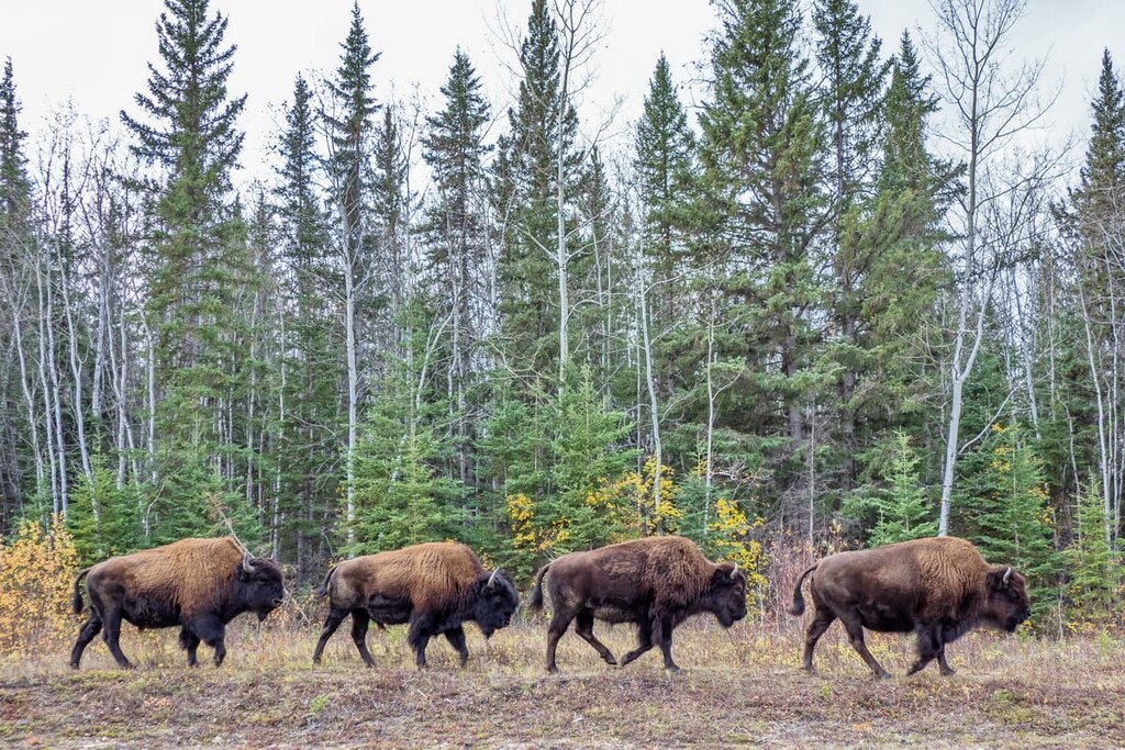
Furthermore, Birch Mountains Wildland Provincial Park is home to one of Canada’s only free-roaming wood bison herds outside of Wood Buffalo National Park.
Wolves, coyotes, moose, white-tailed deer, and boreal woodland caribou are at home in the hills and forests of the region, too. Meanwhile, Wood Buffalo's lakes are inhabited by Arctic grayling, goldeye, lake whitefish, mountain whitefish, northern pike, and walleye.
It is speculated that humans have inhabited the area that is now called Wood Buffalo for much of the last 7,000 to 8,000 years. Records show that the Chipewyan and Beaver First Nations inhabited the region before the eighteenth century and that the Cree First Nations, Métis Nation, and European-Canadians started to settle in this northern wilderness by the 1870s.
The contemporary members of the Chipewyan and Cree First Nations who live in Wood Buffalo often continue their traditional practices of fishing, hunting, and trapping. Projectile points and other artifacts have been uncovered throughout the region, too. These cultural artifacts are especially prevalent around the Birch Mountains, and they have been important in the process of piecing together the early human history of the region.
Archaeological evidence and cultural knowledge suggest that the first inhabitants of the region were influenced by Indigenous cultures in northern British Columbia, Alaska, and Yukon. It is likely that the Indigenous peoples of northern Alberta thrived and traded goods and knowledge with the many other Indigenous communities around them.
Peter Pond is credited with being the first European to enter the Athabasca region and make contact with the First Nations of the area. Furthermore, in 1778, he was the first to write about the occurrence of the oil sands along the Athabasca River (though it’s clear that the First Nations in the region had already known about this unique resource for generations).
That being said, Waupisoo of the Cree First Nations is known to have brought samples of the oil sands to the Hudson’s Bay trading post at Fort Churchill in 1717. As a result, some European traders had seen the tar sands before Pond ever set foot in the region.
Before the era of the international fur trade, many First Nations in the region lived a nomadic lifestyle as small family groups that traveled seasonal rounds to hunt and gather in different areas.
During the nineteenth century, traders such as Paul St. Germain learned to use traditional techniques of gathering materials in the region that is now Wood Buffalo. These techniques allowed St. Germain to build birch bark canoes and winter huts so that he could survive in the northern forests.
One of the most important periods in Wood Buffalo’s history, however, came in 1908 when prospectors recognized the economic potential of the oil sands. Widespread extraction of the oil sands didn’t pick up steam, however, until around the 1940s when Dr. Karl Clark created a technique to separate the bitumen from sand using hot water.
The first commercial developments of the oil sands began in the late 1960s with the start of the Great Canadian Oil Sands Project. Nowadays, most of the residents of Wood Buffalo currently work for the oil companies or in industries that service the oilfields and their employees.
Although the oil sands remain an important economic driver for the region, they are controversial across Canada as extracting oil from tar sands emits more pollution than conventional crude oil. The production of oil in general in the region is also controversial as much of the country looks toward developing more sustainable energy sources.
The incredible northern wilderness of Wood Buffalo features many parks and wilderness areas for visitors to enjoy. The following are some suggested hiking and excursion areas in the Regional Municipality of Wood Buffalo to check out during your next trip to the region.
The remote wilderness of Birch Mountains Wildland Provincial Park offers many activities for visitors to enjoy. Some of the many activities that are available in the park include backcountry camping, canoeing, kayaking, fishing, hiking, hunting, wildlife and bird viewing, snowmobiling, and OHV use.
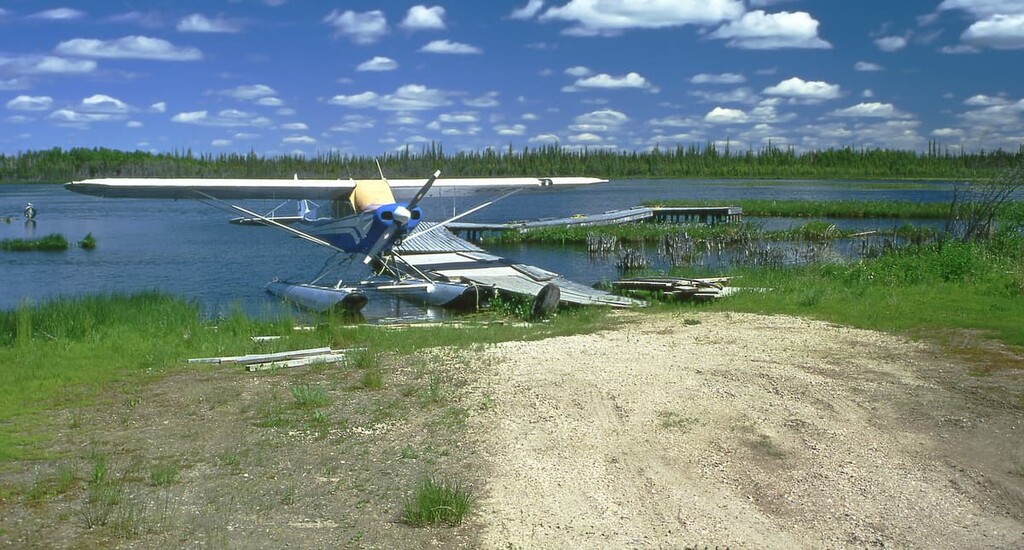
As there are no roads that lead to the area, entry to Birch Mountains Wildland Provincial Park is limited to fly-in transportation during the summer. In the winter, there are roads that lead to regional snowmobile trails, which you can use to access the park when there is sufficient snow cover. Many of these snowmobile trails also lead to popular fishing spots where you can cast lines for lake trout, northern pike, and Arctic grayling.
Located adjacent to the Regional Municipality of Wood Buffalo is Wood Buffalo National Park. Although it is technically situated outside of the regional municipality, this aptly named national park is home to the world’s largest herd of free-roaming wood bison. It also boasts opportunities for camping, swimming, hiking, wildlife watching, backcountry excursions, and northern lights viewing.
Wood Buffalo National Park is also the world’s largest dark sky preserve. This means that, on clear nights in the park, the stars are bright and the aurora borealis may dance for you. During the day, some of the neat trails to hike in the park include the Karstland Trail and the trail to the Salt Plains where you can view the effects of the geological forces that underlie this park.
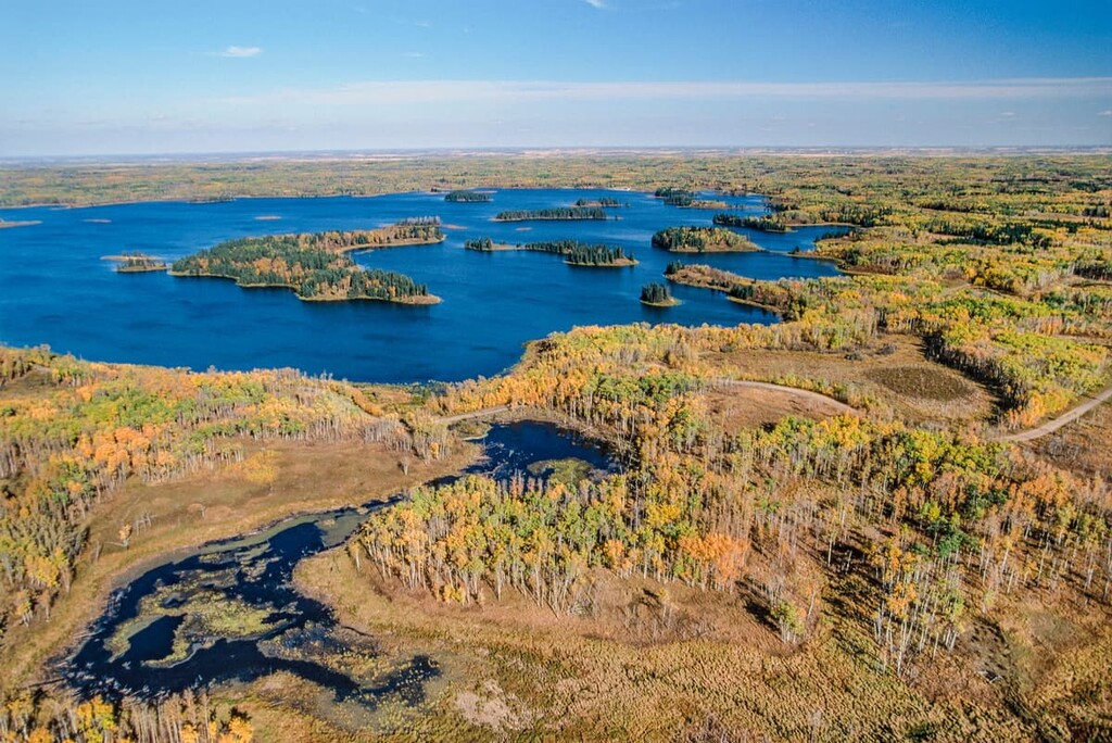
There are a couple of locations where you can visit and explore the fascinating and wild Athabasca sand dunes, including Athabasca Dunes Ecological Reserve and Richardson River Dunes Wildland Park.
The ecological reserve is surrounded by Maybelle River Wildland Provincial Park. While the activities on offer are limited, the sights and experience of the 12 m (40 ft) tall sand dunes and 60 m (200 ft) kames that you can find in the park are exceptional.
The reserve is also home to many significant species of flora and fauna, and it boasts nesting sites for loons and other birds. There are ATV trails from Fort Chipewyan that lead to the edge of the reserve. However, if you’d prefer to spend the day riding and sightseeing, it’s best to check out the many trails that travel along the dunes near Richardson River Dunes Wildland Park.
Keep in mind that motorized access in the park is prohibited, though there are many trails around the park that offer opportunities for hours of riding. The backcountry of Richardson River Dunes Wildland Provincial Park is also an ideal place for hiking, camping, and fishing. There are rustic campsites along the lake that are available on a first-come, first-serve basis, too.
Northern Alberta is a sparsely populated place and the Regional Municipality of Wood Buffalo is no exception. That said, there are a number of cities and towns that are located around the regional municipality. Here are some of the best places to check out during your next trip to Wood Buffalo.
Fort McMurray is the regional urban center for Wood Buffalo and it is located near the southern end of the regional municipality.
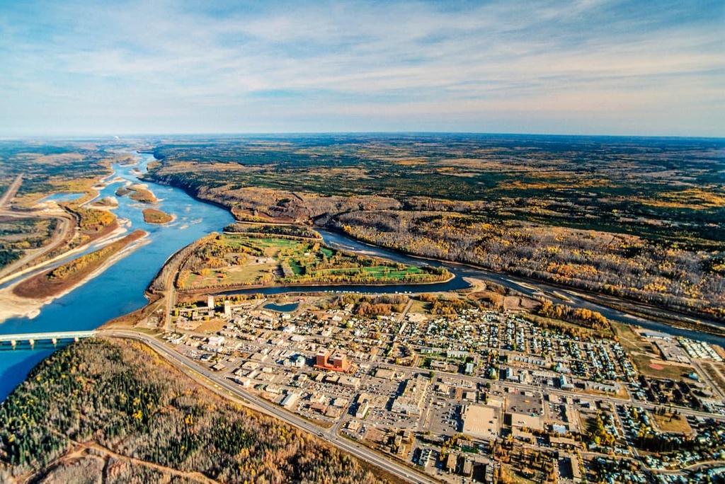
The community of Fort McMurray is a large urban area where most of the region’s residents reside; however, even though it is often mistaken for a city, Fort McMurray is technically not an official city. Rather, it is part of the specially designated Regional Municipality of Wood Buffalo.
Fort McMurray is known for its huge oil sands industry. It is also the transportation and service hub of northeastern Alberta. While the oil sands are prevalent around Fort McMurray, there are also many natural areas that are worth visiting if you’re in the region.
The hiking trails that are located in town include the animal-themed and interconnected Fox, Bear, Wolf, Deer, and Moose trails. There are also paths located near the community of Thickwood that are worth checking out. Additional recreational opportunities can be found at parks near the city, which include Gregoire Lake, Stony Mountain, Grand Rapids, and Gipsy Lake.
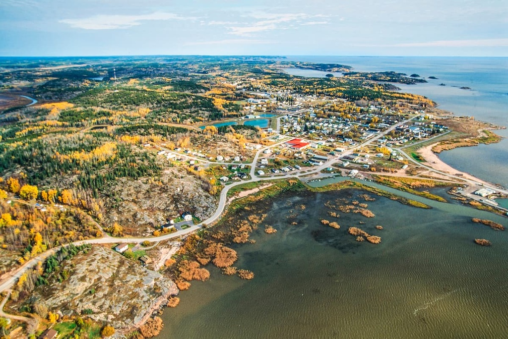
Located on the eastern side of Wood Buffalo National Park and on the northern shore of Lake Athabasca, Fort Chipewyan is one of the oldest European settlements in Alberta as it was first established as a trading post in 1788.
The community of Fort Chipewyan is one of the main access portals to Wood Buffalo National Park during the winter months. While it is possible to fly into Fort Chipewyan during the summer, road access is only possible by ice roads when the temperatures are reliably below freezing (so don’t be fooled by Google Maps, which insists that you can drive to the town during the summer months).
If you happen to find yourself near Fort Chipewyan, some of the nearby wilderness areas that are worth visiting include Richardson Wildland Provincial Park, Richardson River Dunes Wildland Provincial Park, Maybelle River Wildland Provincial Park, and Athabasca Dunes Ecological Reserve.
Fort Smith is a major community that’s located in the Northwest Territories, just to the north of the Alberta border. The community is accessible via the Mackenzie Highway, and it is located along the banks of the Slave River. Fort Smith is also a popular starting point for trips into the northern part of Wood Buffalo National Park.
Originally built by the North West Company in the late eighteenth century, Fort Smith was historically situated at the end of a portage route that bypassed the large and dangerous rapids in the Slave River. Nowadays, many visitors come to Fort Smith to try themselves against these world-class rapids in kayaks and canoes. Other visitors travel to the area in order to access Wood Buffalo National Park.
In addition to being the gateway to Wood Buffalo National Park, Fort Smith is home to the Northern Life Museum as well as the South Slave Friendship Festival, the latter of which brings in artists and musicians from across the Northwest Territories.


