Scan the QR code and open PeakVisor on your phone
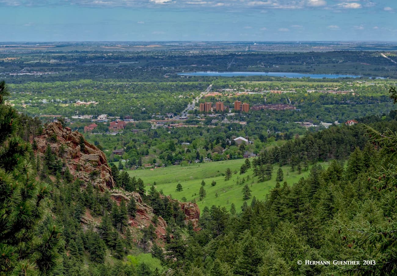
Boulder County in north central Colorado is one of 64 counties in the state. It has a population of 326,000 as of the 2019 estimate. It was one of the original 17 counties created by the Territory of Colorado in 1861. It got its name from the City of Boulder and Boulder Creek, so named because of the abundance of boulders in the creek that hampered early gold prospecting efforts. The City of Boulder, with an estimated 2019 population of about 106,000, lies about 25 miles northwest of Denver and many residents who live there regularly commute to work in the Denver area. About one-third of the county’s land area lies in the flatlands east of the foothills of the Rocky Mountains, while the rest stretches across the foothills all the way west to the Continental Divide, which forms the county’s western boundary.
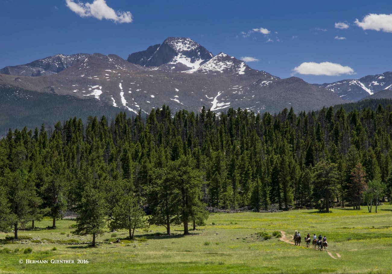
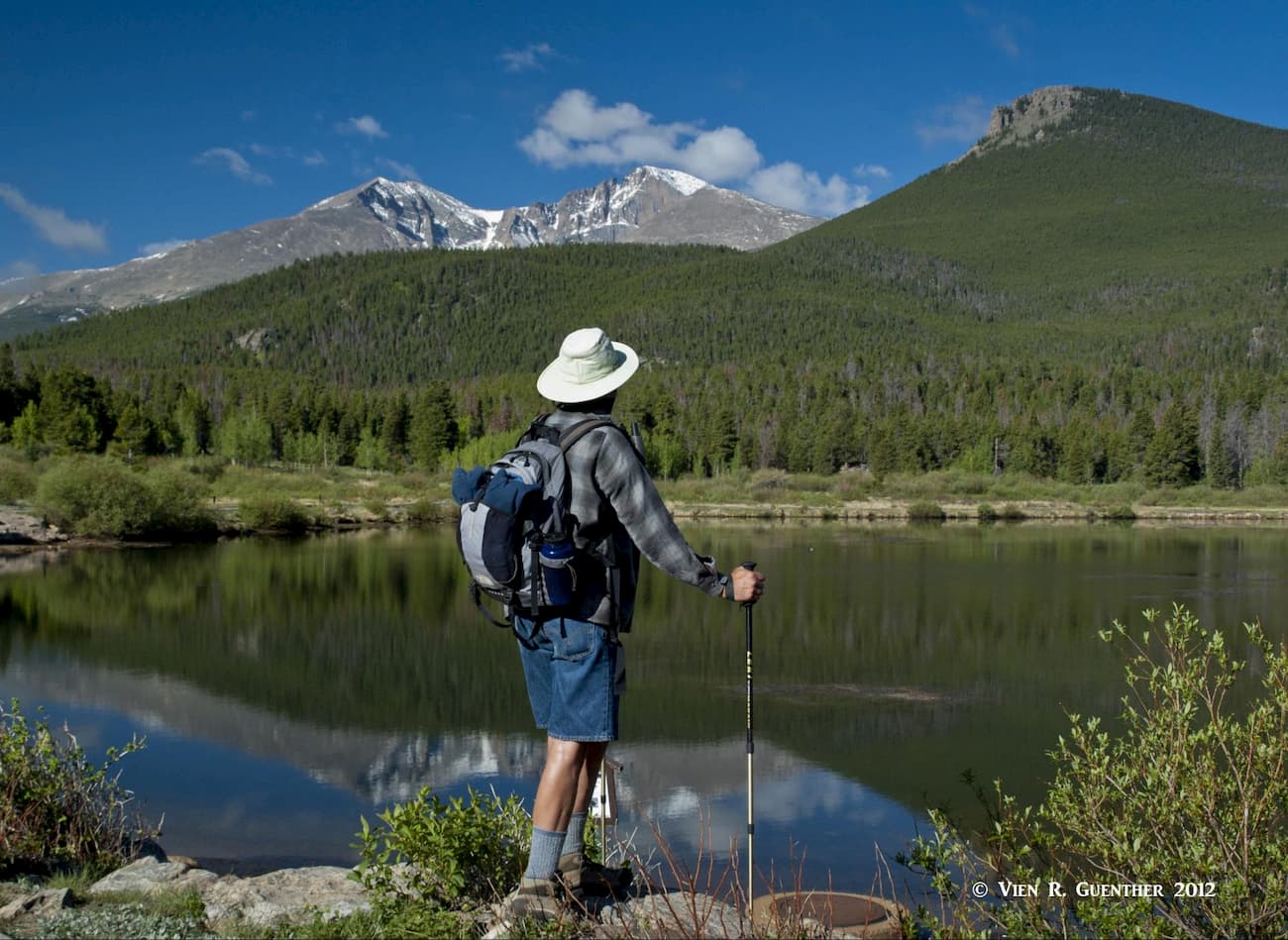
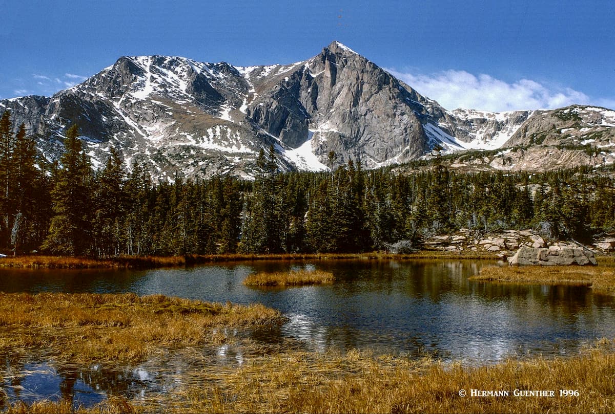
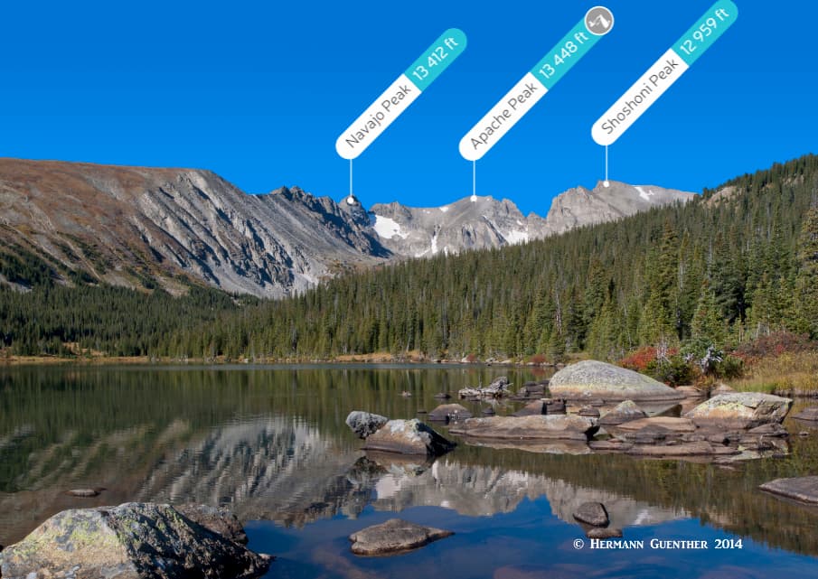
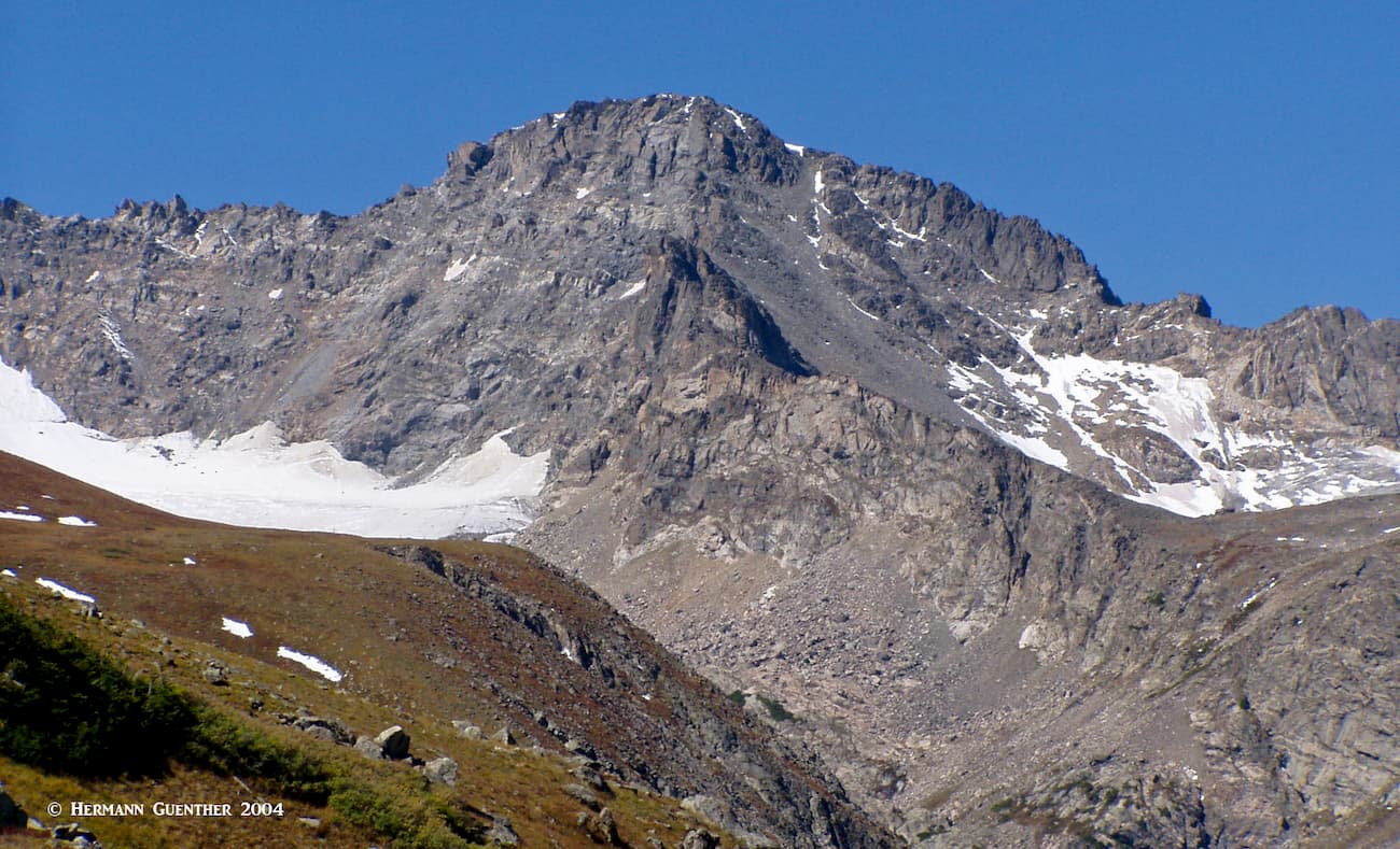
To say that Boulder County is all about mountains would be an understatement. This county is a magnet for hiking and climbing, with some spectacular venues right within the city limits of Boulder itself. The fact that the University of Colorado has its main campus in the city is enough to draw students from around the world simply so that they can be in the mountains. Boulder is the home of many famous mountaineers (past and present) who have gotten their early mountaineering training in the nearby mountains. The county encompasses parts of two national forests as well as a significant part of Rocky Mountain National Park. In fact the highest mountain in the park (and the only fourteener north of Interstate Highway 70 in Colorado), Longs Peak, is in Boulder County.
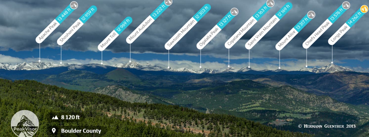
There are 127 named mountains in Boulder County, a number that does not necessarily include additional peaks that straddle the continental divide and are therefore technically also in the county. In addition to being the highest named mountain in the county, Longs Peak is also the most prominent. With so many mountains, many of them perched on the formidable barrier formed by the Continental Divide, it is no wonder that this county attracts a multitude of hikers and climbers. I am one of them and can vouch for the fact that this county offers some of the best there is.
So how do we best illustrate to you what great hiking there is to be had without writing a complete guidebook for the Boulder Mountains (most likely such books exist in abundance)? Let us first examine what other administrative entities share many of these mountains with Boulder County:
Arapaho National Forest – Although the Arapaho National Forest does not extend into Boulder County, part of its eastern boundary is the Continental Divide which it shares with the county. Consequently, some of the named summits located squarely on that part of the divide are technically also in the county as well as in that national forest.
Roosevelt National Forest – This forest is located east of the continental divide and extends north to the Wyoming state line, wrapping around the eastern side of Rocky Mountain National Park. A substantial proportion of the county’s area is within this forest. A number of the high peaks along and east of the divide, as well as numerous other named mountains, are claimed to be both in Boulder County and in the forest.
Indian Peaks Wilderness – This marvelous wilderness area straddles the continental divide for the entire length of the western Boulder County boundary. Therefore, all of the named mountains in the wilderness that are on or east of the divide are also in the county. Those that are on the Divide are also shared with Grand County to the west. Follow this link for lots of information and photos about hiking in this wilderness.
Rocky Mountain National Park – A significant part of this awesome park extends well into Boulder County such that a number of its highest peaks, including the highest of them all, Longs Peak, are either entirely in the county or are directly on the continental divide in which case they are also shared with Grand County.
Grand County – Boulder County and Grand County share a common boundary which is defined by the Continental Divide. Likewise a number of named mountains perched directly on the divide are shared by both.
Front Range – This is the longest sub-range of the Rocky Mountains located entirely within Colorado, the northern section of which encompasses the western two-thirds of Boulder County. This means that all of the named mountains in the county are also contained within this range.
So with all of this overlap, and possible confusion, we have decided here to highlight some of the major hiking areas, but with limited discussion about them, since they are already covered more thoroughly by other articles in the PeakVisor library. All of the above are linked to their respective articles. Instead, in the interest of avoiding too much repetition, we will primarily focus here on other hiking areas in Boulder County that did not get as much attention in those articles, which we highly recommend for your reading pleasure.
Boulder County offers a diversity of recreation opportunities, far too many to discuss here. A web search will reveal more things to do than you can imagine. But when it comes to hiking and climbing, we can help, since PeakVisor has gone far beyond just the app that lets you identify mountains. We want to help you enjoy the mountains and tell you about the special places, some that may not be on the obvious “to do” or “must see” lists. The following hiking descriptions will present you with a choice of some better-known as well as other “not-so-well-known” places. But keep in mind that the locals (the “Front Range Crowd”) are intimately familiar with all of them.
This third-highest ranked national park in the United States in terms of annual visitors, couldn’t be much closer to Boulder County and City – in fact it is partly in the county. But the majority of visitors, coming from all over the world, will enter the park at its main entrance in the town of Estes Park. There they will discover a magic mountain world. They will visit the major sites, take lots of photos, and go hiking in places that are the envy of mountain lovers the world over. But many of these visitors will likely not know about some “secrets” that we locals hold dear.
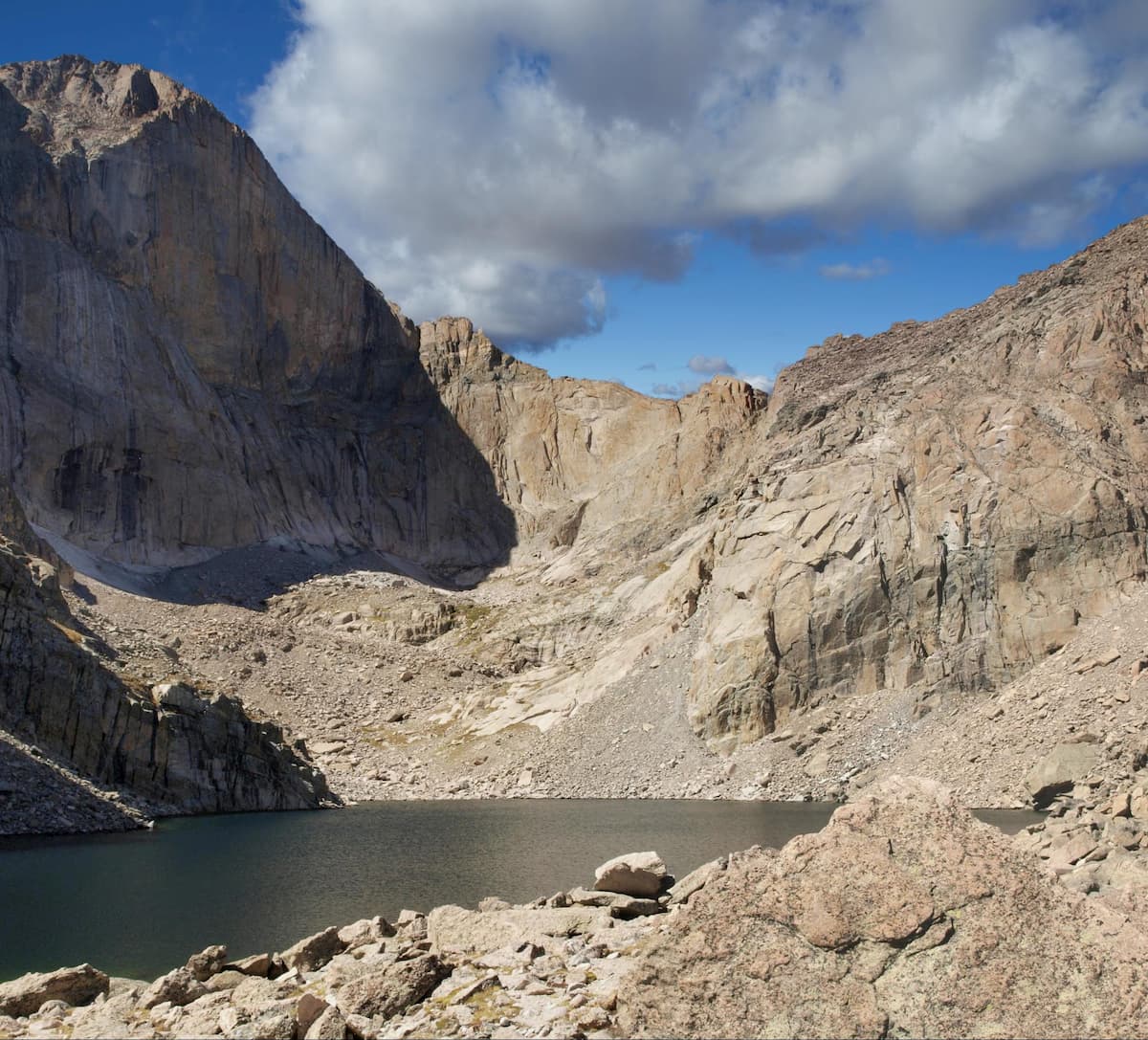
Longs Peak Trail - Yes, lots of people come to RMNP to climb Longs Peak - about 15,000 attempt to climb it each year, but only about half of them make it and almost all of them start by hiking this trail. But you don’t have to climb this behemoth to experience a really grand hike that will test your conditioning. I have once hiked this trail as far as the famous boulder field, which is three-fourths of the way up the mountain. That is where the climbing begins. As an alternative to climbing the peak, I highly recommend that you take the trail to the Chasm Lake junction at about 3.7 miles in and continue on the left branch until you reach the lake at almost five miles. This is a truly amazing hike and the scene at the lake is something that you can only appreciate if you are actually there, since no photographs can do justice to what you are seeing. Staring you in the face will be “The Diamond”, the sheer 900-foot-high north face of Longs Peak. It was first climbed in 1960 and has since become one of the classic climbs of North America.
Wild Basin - The Wild Basin area is the southernmost part of RMNP and extends all the way south to the Indian Peaks Wilderness. The entire basin and its many trails and lakes are in Boulder County and offer a wide variety of hiking opportunities. A word of caution is appropriate here - some of the hikes are long and may not be suitable for families with small children. But if you are an avid hiker, you should explore this huge wilderness. There are four major trails in this area and they all lead to splendid high alpine lakes. I have hiked all of them - several times. While Wild Basin has become a lot more popular over recent years, you should still find a lot less hikers on the trails here than in the far more popular main part of the park. Since this area is south of Longs Peak, you will be treated to a far different view of it from some of the trails.
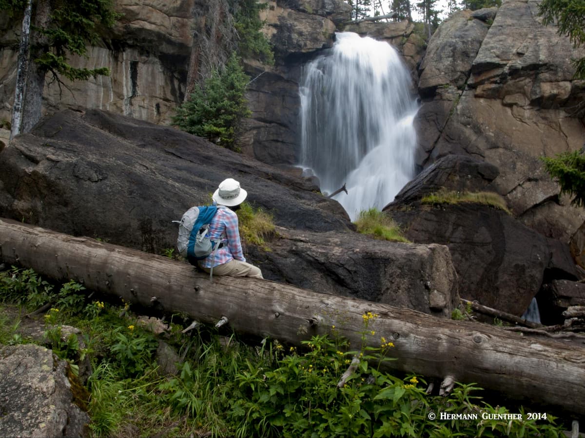
Perhaps the most popular hike here is to Ouzel Falls. At only about three miles one way, with no more than 1,100 feet of elevation gain, this is an easy hike for anyone in reasonable condition. On the way there, you will first pass the very scenic Copeland Falls - not tall, but so worth taking the slight detour to see. Further up the trail, you will pass Calypso Cascades, the name of which should be self-explanatory - a long series of small falls just before you get to Ouzel Falls. But it is the latter that most visitors come to see.
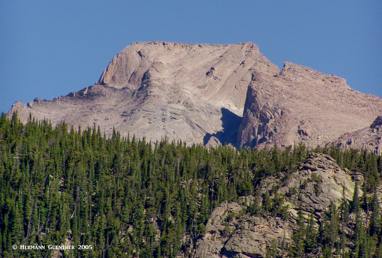
If, after having seen Ouzel Falls, you are still up for more adventure (lots more) continue the hike to Ouzel Lake and the far more scenic Bluebird Lake.This will make a more strenuous hike of about 13 miles with an elevation gain of almost 3,000 feet. It is a beautiful hike, and it was not crowded at all the times when I did it. The beautiful high-alpine Bluebird Lake is backed up by Ouzel Peak, which just beckons the hiker to climb it, although I did not get to do it. It sits squarely on the Continental Divide at an elevation of 12,697.
If you are up for a long day hike, you can take the trail to Thunder Lake (surprisingly, I never ran into any thunder there) or two miles prior to getting there, take the side trail to Lion Lake No. 2 (never saw any lions there either, although Mountain Lions should not be counted out). Either hike will be between 14 and 15 miles, but the hike to Lion Lake requires about 500 feet more elevation gain - a total of about 2,500 feet. From this lake you will get a fine view of Mount Alice, elevation 13,315.
This is the only Colorado State Park in Boulder County. It is most famous for its rock-climbing walls, although hiking trails exist also. The park only has one entrance road which can be reached by driving State Highway 93 (south from Boulder or North from Golden) and then turning off on State Highway 170. There are not many trails in this small park but it is a pretty spectacular place to visit nevertheless. The main hiking trail is the 3.5-mile (one way) Eldorado Canyon Trail. So why would you want to just go on this trail only to come back the same way? Well, I decided to find out and indeed I did. You see, this trail connects to the much longer Walker Ranch Loop Trail – part of which is within the park’s boundary and the rest is in Boulder County’s Walker Ranch Park. The loop is almost eight miles long and has several significant elevation gains and losses. Well, that would make a hike of almost 15 miles. I’ve done that a few times, but nowadays that is too much for me or my wife. Fortunately, there is a better way to hike the loop only – it has three different access points with parking. It has since become one of our favorite foothills hikes, but it can be very hot in the summer due to fairly low elevations. Winter is a lovely time to make this hike. Another advantage – you can avoid the long approach from and back to the state park, and no fee has to be paid to hike the loop.
The Brainard Lake Recreation Area is less than 25 miles from the heart of the city of Boulder, placing it just about in the center of the mountainous parts of the county near the town of Ward. This place is popular, extremely so, and for good reason. The trailheads that can be found here provide access into some fantastic areas of the Indian Peaks Wilderness. There is a sizable campground here making it very easy to get to your favorite trails from your place of “residence”. Yes, you have to pay a fee to enter this area in the summer months, but it is well worth the price. In the off-season you can still enter, but you have to park outside of the entrance gate – a large “winter” parking lot is provided there – and walk an extra three miles to the main trailheads. At those times there is no fee and lots of people take advantage of that, since this is a popular place for cross-country skiing.
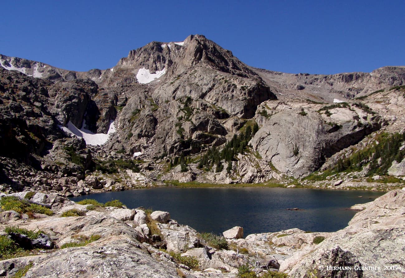
There are two major trailheads here – the Mitchell Lake and the Long Lake Trailhead. The Mitchell Lake Trailhead is the one you want if you plan on hiking to Mitchell Lake (of course!) which is only a very short hike with little elevation gain. Pretty much anyone can do this one, but if you want a little more exercise you can continue the rest of the trail to the beautiful Blue Lake. A total one-way distance of three miles makes this a moderate hike that is so well worth doing. The fantastic view of Mount Toll across the truly blue lake is simply stunning. Also starting at this trailhead is the Beaver Creek Trail, which is mostly used by hikers who want to climb the 13,229-foot Mount Audubon, though the trail continues north for a considerable distance to connect with another trail network.
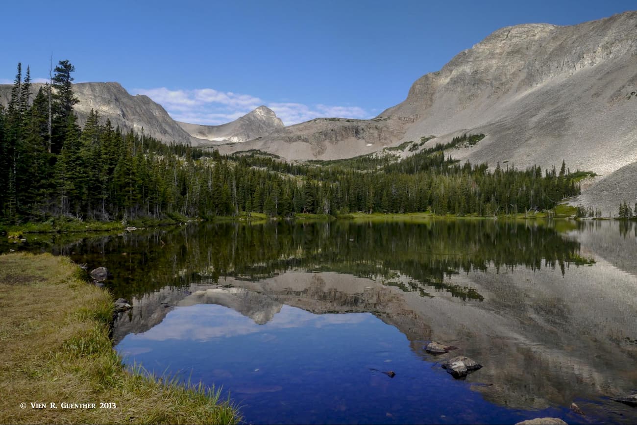
The Long Lake Trailhead is the place to start if you want to not only see some spectacular lakes, but also the place from where you can climb all the way up to and over the Continental Divide at Pawnee Pass. From this amazing pass, you can continue for miles to many incredible destinations. One of my favorite lakes in the Indian Peaks Wilderness is Lake Isabelle, which lies just past the trail junction where the Pawnee Pass Trail diverts from the Isabelle Glacier Trail. Though I have never gone to the glacier, I have been to the lake a number of times. It’s an easy hike of about 8.5 miles (if you include hiking around the lake – be on the lookout for moose up there) with only 1,000 feet of elevation gain. This hike also includes a loop around Long Lake which is very worthwhile doing without adding any substantial distance to your hike.
Near the town of Nederland, 16 miles due west of Boulder City, is the old mining town of Eldora from which you can easily reach two major trailheads – the Hessie Trailhead and the Fourth of July Trailhead. The trails emanating from both of these are among the most popular in the entire Boulder County as they provide access to incredible terrain in the Indian Peaks Wilderness. From the Hessie Trailhead you can hike to no less than eight pristine alpine lakes, the favorite of mine being King Lake, which sits right below the Continental Divide. Above the lake, you can hike for miles along the divide and then return to your starting point via a different trail. This 16-mile loop hike is known as the High Lonesome Loop. This is tough – and if you are too, you will really enjoy this hike. I have done it a few times in years past.
The main and only trail beginning at the Fourth of July Trailhead is the Arapaho Pass Trail. This long trail eventually crosses the Continental Divide at Arapaho Pass and then continues miles beyond. Just a few hundred yards above the pass is the amazing Lake Dorothy – if you are not familiar with this area, you would not expect to find a lake here. But before you even get to the pass, you can take Arapaho Glacier Trail to climb the delightful South Arapaho Peak (and even make the exposed traverse to North Arapaho Peak). The views from there are epic. One of my favorite summits in Colorado.
And if you want a really easy hike from this trailhead, take the diversion to Diamond Lake. The trail will descend slightly over the next half mile from the junction until you get to a pleasant waterfall. After crossing the creek below the fall, the trail gets a bit steeper for the final ascent to the lake. Around the lake there are designated campsites - you must have a permit to camp here as everywhere else in the Indian Peaks Wilderness. But that applies only from mid-June to mid-September. This is a very popular spot to enjoy wildflowers, especially if you continue along a less-used trail to the Upper Diamond Lake. Above the lower lake you will find few other hikers.
While the Rainbow Lakes are nothing very dramatic, a short trail leads to them from this trailhead, which is right beside a Forest Service campground. But also at this location is the eastern end of the Arapaho Glacier Trail (see above) which you can follow all the way up to the two Arapaho Peaks (South and North). The final scramble to the south summit is the same as you would do if you were to approach from the Fourth of July Trailhead. This approach is considerably longer but you get the benefit of miles of hiking above the treeline, thus affording some awesome views. The climb requires more elevation gain from this side and it is likely that you will encounter fewer people. The east face of North Arapaho Peak is a truly fine sight from this trail.
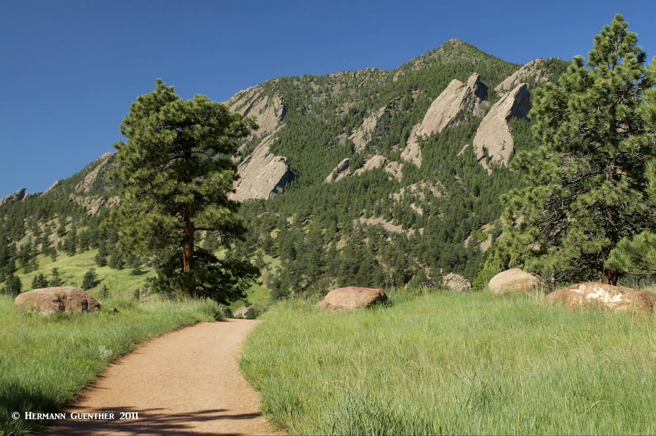
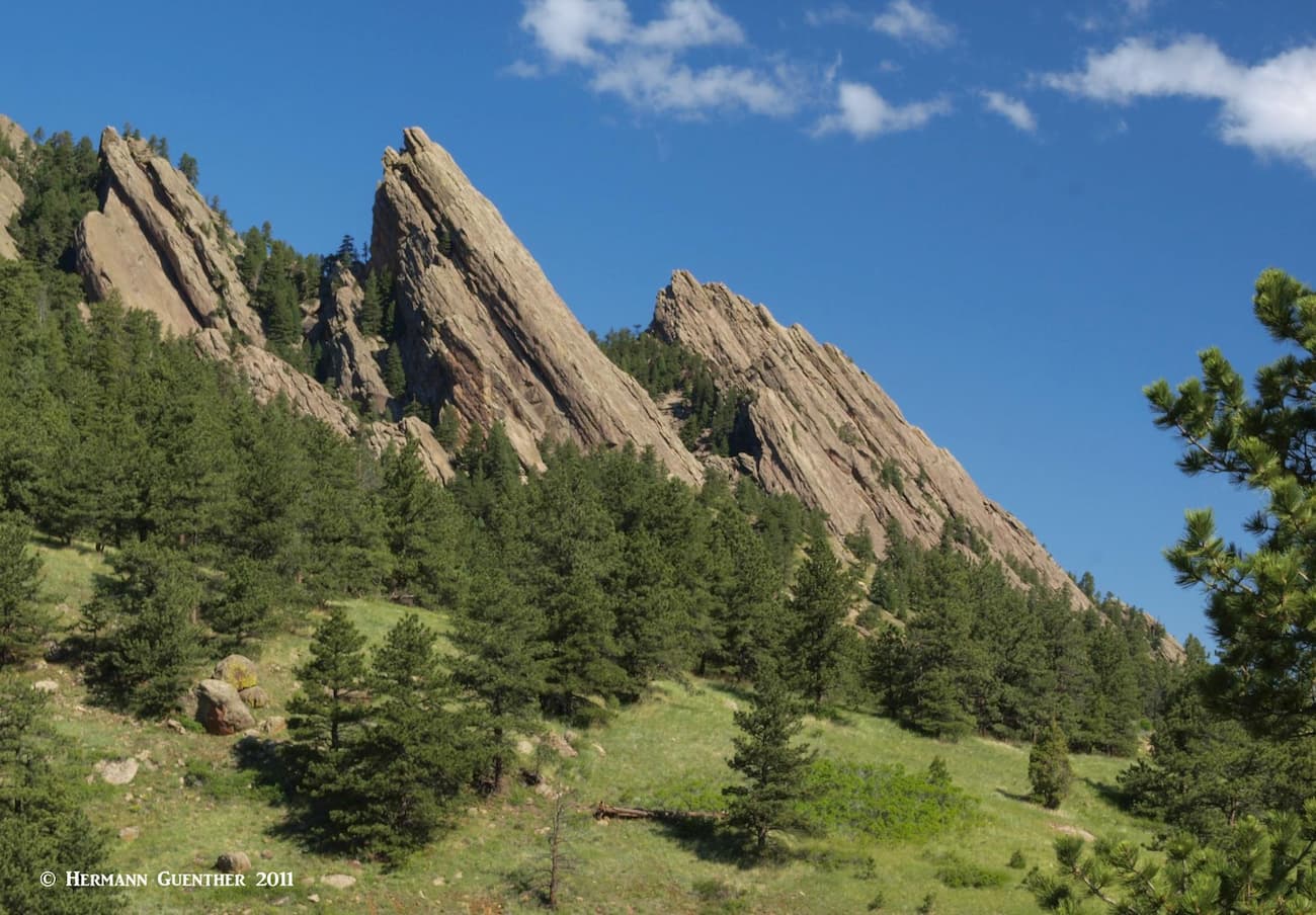
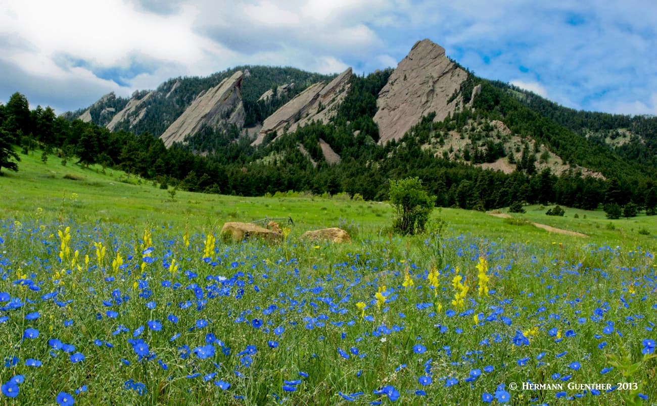
So far we have talked about the most important hiking places in Boulder County by focusing on trails in the high mountains. But we must not overlook the spectacular hiking and climbing that can be done right within Boulder city limits. These mountains deserve some serious attention. Yes, the western residential areas of the city are so close to these amazing foothills that some residents don’t even have to get into their cars to start hiking. They can just walk from their homes. Well, we don’t live in Boulder but it is close enough that we can be at some trailheads in about about a half hour. In the forty years that I have been living in the western suburbs of Denver, I have hiked just about all of the trails in the city’s Open Space and Mountain Parks (OSMP) system – many times. While I don’t do any technical climbing (of which there is plenty in the famous Flatirons and other formations such as the Maiden), there are some really challenging hikes, some of which are not for everybody.

The trio of mountains at the western edge of the city – South Boulder Peak, Bear Peak and Green Mountain – are beyond comparison in terms of the variety and length of trails. You can climb just one of them for a good workout, combine any two of them (although not South Boulder Peak and Green Mountain since Bear Peak sits between them), and, if you are really ambitious, you can combine all three. Trust me, the latter option is a serious undertaking, especially if you don’t have a car shuttle and need to return to your starting point. This involves a loop hike of about 18 miles with an accumulated elevation gain of 5,400 feet. I’ve done this only twice, and believe me, don’t attempt this in the summer since it can get really hot – the highest elevation is only 8,527 feet. But the combination of South Boulder Peak and Bear Peak is considerably easier, though not exactly child’s play – you can still be looking at anywhere from 8 to 14 miles depending on which trail combinations you choose. I have done this well over 30 times, the most recent in 2016.
Mesa Trail - The six-mile Mesa Trail follows along the eastern side of these mountains, meandering as it goes, with many ups and downs along the way. If you want to do this trail from one end to the other and back again, you will get quite a workout. But it is this trail that makes combination hikes of the three peaks possible. The south trailhead is on the Eldorado Springs Drive (State Highway 170), while the north end is at Chautauqua Park near central Boulder. Following are some sample hikes you can make from either trailhead.
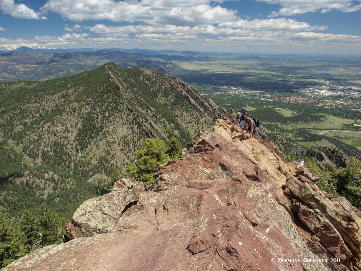
South Boulder Peak – Bear Peak via Shadow Canyon – This hike starts at the South Mesa Trailhead and makes possible the shortest hike combining both peaks. This means ascending and returning via Shadow Canyon - a hike of only about eight miles, with a total elevation gain of about 2,900 feet. This is the easiest way to climb both peaks in one hike. The view from the impressive summit of Bear Peak is epic – the whole Denver-Boulder metropolitan area to the east, the high mountains of the Continental Divide to the west. On a clear day, you can see from Pikes Peak in the south to Longs Peak in Rocky Mountain National Park in the north – 100 miles apart.
South Boulder Peak – Bear Peak via Shadow Canyon and Fern Canyon – This route requires going one way up Shadow Canyon, making the diversion to South Boulder Peak, then the easy traverse to Bear Peak, followed by the very steep descent down Fern Canyon to where it intersects the Mesa Trail. From there you need to hike back to the South Mesa Trailhead. This is a 10-mile hike, but with a total elevation gain of 3,700 feet due to the many ups and downs on the Mesa Trail. Definitely one of my favorite hikes in the foothills.
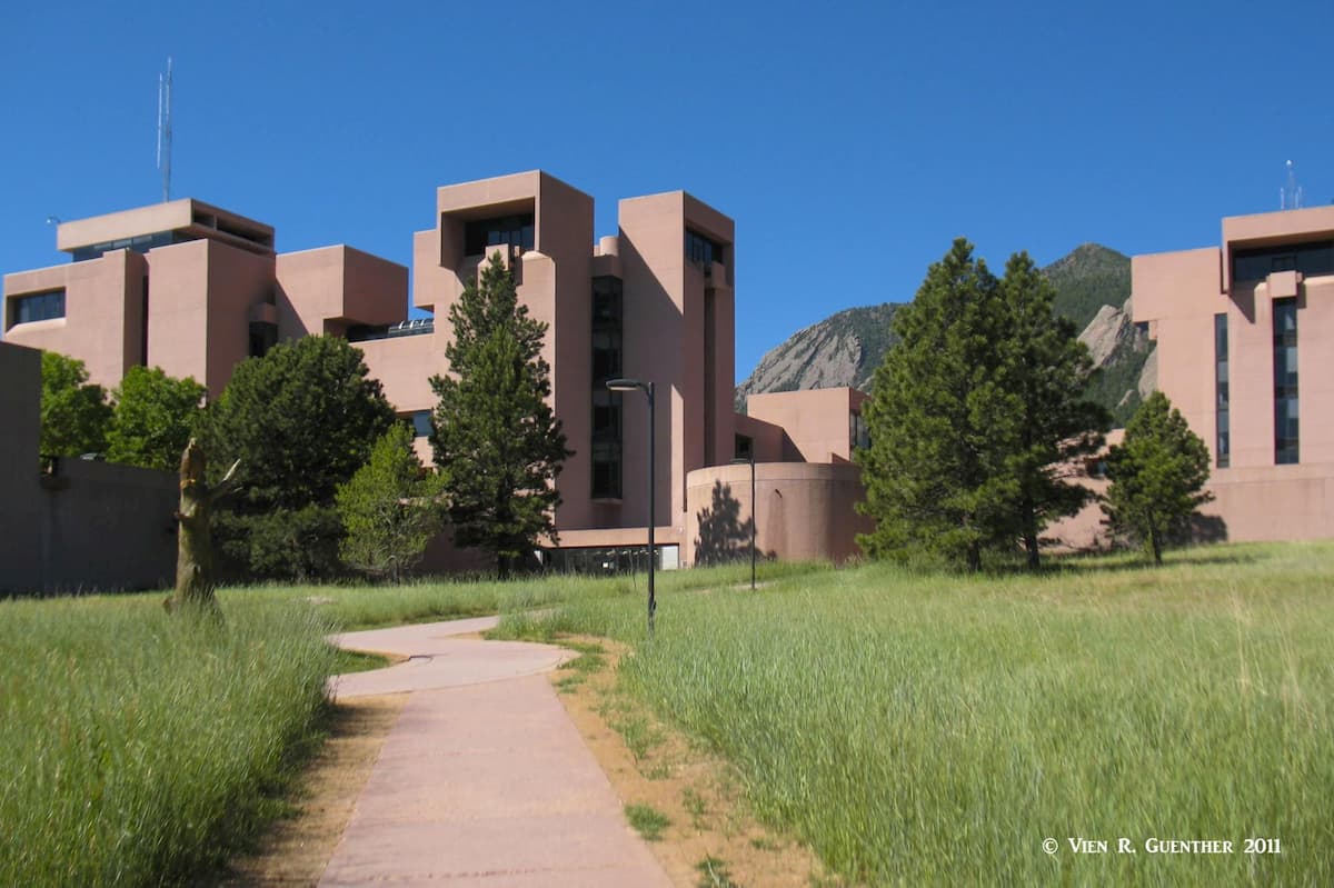
Bear Peak from the NCAR Trailhead via Fern Canyon and Bear Canyon – NCAR stands for National Center for Atmospheric Research, a fascinating facility perched on the flat top of Table Mesa (a redundant name since mesa is the Spanish word for table), that has a museum section open to the public at no charge. It is really worth visiting. This hike begins at the huge NCAR parking lot and soon joins the Mesa Trail which you take to its junction with the Fern Canyon Trail. Remember the steep trail I mentioned earlier – yes, you will climb up that one. It is without doubt the steepest trail in the OSMP system and will get your heart pumping. From Bear Peak summit, you then leave the top via the Bear Peak West Ridge Trail until it reaches the Bear Canyon Trail, which you take back to your starting point. This hike is 8.5 miles long and has a total elevation gain of 3,000 feet. You can of course exercise the option of climbing Green Mountain from the end of the West Ridge Trail, but that adds miles and lots of additional elevation.
Green Mountain – If you want to do a much easier hike and still reach the summit of one of the three peaks, you can do what my wife and I love to do - a far less strenuous hike than the others. Though Green Mountain is the lowest of the three Boulder peaks in this group, it still reaches an elevation of 8,144 feet, which will give you a respectable overall elevation gain of 2,500 feet in a round-trip distance of 6.5 miles. I love to do this hike as a clockwise loop, starting at and returning to Chautauqua Park. From a short connecting trail, take the Saddle Rock trail up until it meets the Greenman Trail, which you then take to the summit. The Saddle Rock Trail affords a fine view across Chautauqua Park to the University of Colorado main campus.
From the top, there are great views down to the city and the entire greater Denver area, as well as to the chain of high mountains in the west defining the Continental Divide. From the top, take the Ranger Trail to its junction with the Gregory Canyon Trail, which you take to the bottom, from where a short connecting trail takes you back to where you started. This is a favorite route that is not nearly as strenuous as any of the routes to South Boulder or Bear Peaks. As you start out on this hike from Chautauqua Park, take a good look at the impressive Flatirons right in front of you.
The beautiful City of Boulder (population 107,353 per 2018 estimate) enjoys a spectacular mountain setting that few cities of its size can boast. Aside from being the seat of Boulder County, it is itself a hiker’s and climber’s destination, not to mention its easy access to countless mountain venues. Many famous climbers and mountain explorers call (or have called) Boulder home. And for good reason – where else can you find such an out-of-this-world training ground? Boulder is so well positioned as to make it the perfect base from which to explore the high peaks of the easternmost segment of the Continental Divide, as well as part of Rocky Mountain National Park. Even the high foothills looming over the city afford some impressive hiking and climbing opportunities - right within city limits. The highly outdoor-oriented population of this town contributes significantly to the hordes of people that want to play in these mountains. And then there are the 17,000 students of the University of Colorado, based here, who want to do more with their time than just study for their degrees.
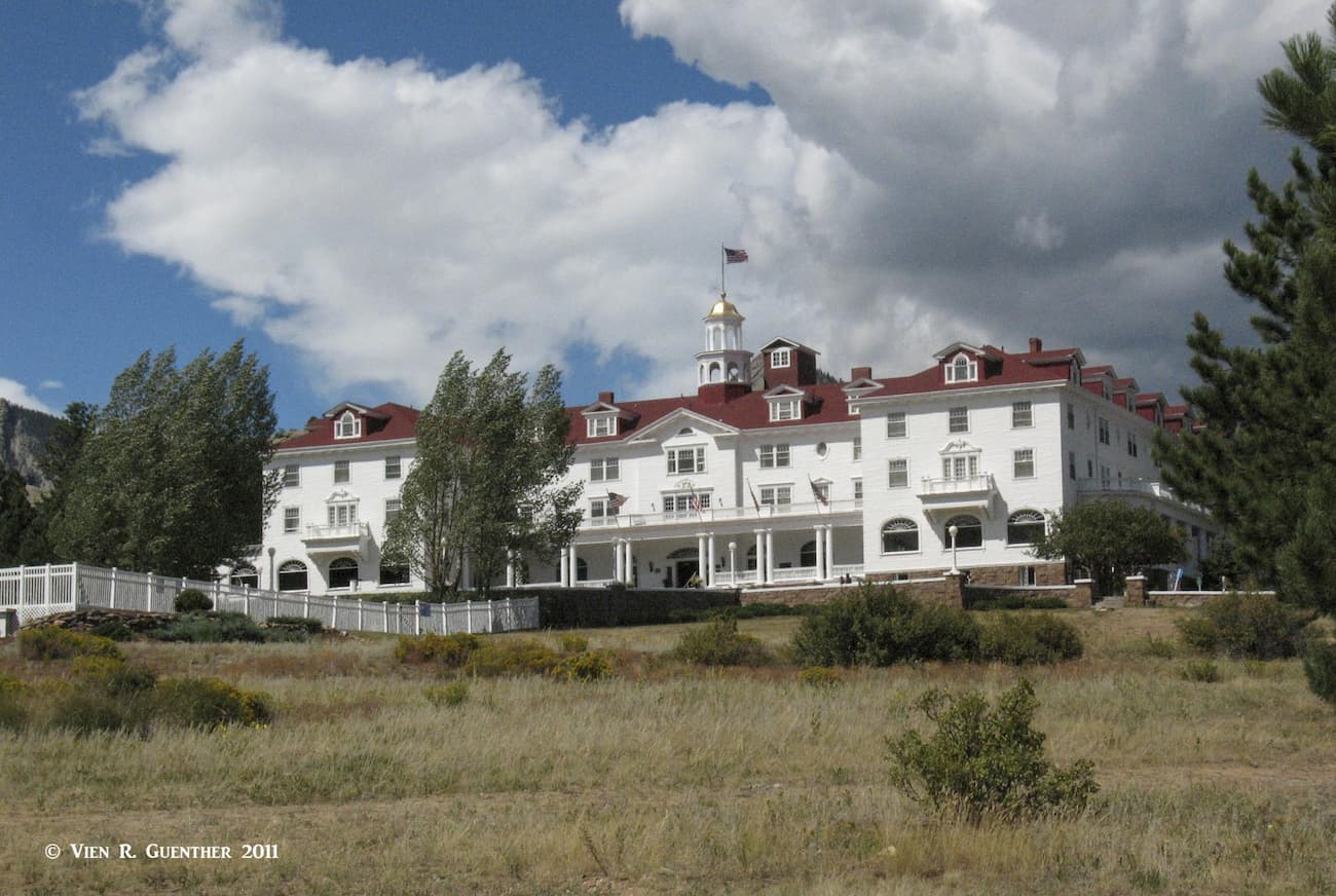
Known primarily as the gateway to Rocky Mountain National Park (RMNP), Estes Park is a charming resort town that must be visited when in the area. It offers all the amenities one could want in a mountain resort – fine dining, comfortable accommodations (affordable and upscale - such as the “ghost infested” Stanley Hotel that was the inspiration for the horror movie “The Shining”) and enough shopping to keep visitors happy on a rainy day. Though most visitors to Estes, as the locals call it, gravitate to the main attractions in RMNP, this lovely town is also very handy to the other areas of the park, those areas that are in Boulder County. The Longs Peak area, for example, is just a few minutes’ drive from the town, as are the trailheads to Twin Sisters Peaks and Estes Cone. Even the other major trailheads in Boulder County can be reached from here in about one hour, and those who would like to hang out in a more urban setting, the center of the City of Boulder is less than an hour away.