
Scan the QR code and open PeakVisor on your phone
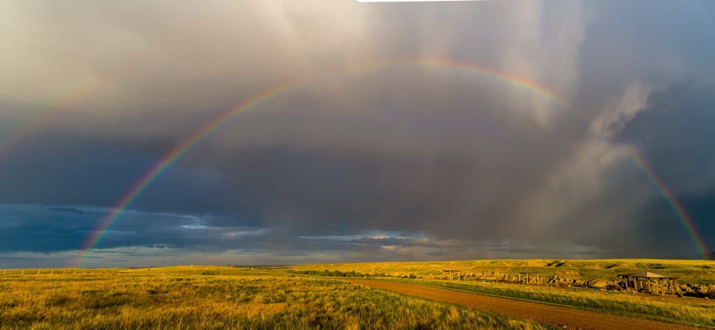
Birch Hills County is a municipal district located in northern Alberta Canada. The municipal district is situated to the south of the Peace River. There are no cities or towns in the sparsely populated county, only several hamlets. The county is named for the Birch Hills, which are the major geological feature in the region, aside from the Peace River. At their tallest, the birch hills stand approximately 687 m (2,254 ft) above sea level.
Birch Hills County is a municipal district situated in northwest Alberta, Canada. It is located along the southern banks of the Peace River, and it is bordered by the Smoky River to the east.
The county is surrounded by several other municipal districts. This includes the municipal districts of Peace, Greenview, Spirit River, Saddle Hills, Smoky River, Grand Prairie, and Northern Sunrise.
The district takes its name from the Birch Hills, which is a collection of hills in the area. The Birch Hills were named by Cree First Nations prior to European settlement of the region.
There are no cities, towns, or villages in Birch Hills County. However, there are a number of hamlets, including Eaglesham, Peoria, Tangent, Watino, and Wanham, the latter of which is home to the municipal offices. There are about 1,600 people who reside in the district. Oil and gas provide the largest sector of employment in the county.
The topography of Birch Hills County isn’t as dramatic as what you might find further to the south or west in the Canadian Rockies, the Birch Hills do reach an elevation of approximately 687 m (2,254 ft) above sea level.
That said, the geology of the region is fascinating. The geological history of the region begins about a billion years ago when North America was part of the ancient supercontinent Rodinia.
As part of Rodinia, much of North America was submerged under a shallow sea where it accumulated layers of marine sediment that were upward of 8 km (4.8 mi) thick.
About 800 million years ago, the currents within the Earth’s mantle shifted and Rodinia was pulled apart, creating a new western coastal margin for North America that’s roughly the same as the current border between Alberta and British Columbia.
While most of the rock that accumulated in the inland sea was ripped away during this time, there are remnants of it in both northern and southern British Columbia. Geological fieldwork has since uncovered that North America’s ancient western coast was connected to Australia at the time of the Rodinian supercontinent.
This rifting stretched out the coastal margin of the continent, and, as a result, huge blocks of crust tilted and slid along fault lines. Rivers found easy paths to the expanding ocean through these fault lines and quickly eroded away layers of the continent, depositing the sediment offshore in the submerged trenches and valleys.
The Peace Region, which contains what is now the Birch Hills, then became a broad plain located along the ancient coastline of North America. It endured eons of erosion as the sea levels rose and fell over the course of approximately 100 million years.
The Peace Region was filled with a shallow sea where cyanobacteria flourished, creating layers of limestone in the process. As the sea rose, these cyanobacteria would live, die, and be buried in a layer of sand and mud.
As the sea receded once again, the cyanobacteria flourished and would create another layer of marine sediment. The cycle of the advance and retreat of the sea created the layers of shale, sandstone, and limestone that currently compose the bedrock of the Peace Region.
About 425 million years ago, the continental margin along the current British Columbia-Alberta border was uplifted, creating a ridge extending from the Peace Region to Montana. The West Alberta Ridge forced the ocean to enter the continent from the north. Combined with North America’s tropical location at the time, the warm seas and tropical coastline fostered an abundance of life.
Erosion worked at the West Alberta Ridge until only the north end of the ridge remained, as the Peace River Arch, which persisted for several million more years. These warm and shallow seas promoted the growth of stromatoporoids whose porous skeletons accumulated around the Peace River Arch as massive reefs.
Once the conditions of the seas again became unfavorable for the reef builders, the reefs were covered by the rapid influx of sediment that had eroded from the continent.
Since the burial of the reefs, about 425 million years ago, the organic oil, which was the product of dead algae, was pressed into the reservoirs created by the porous reefs of the stromatoporoids. Over time, heat and pressure converted the organic oil into the crude oil and natural gas that is extracted for commercial purposes to this day.
At the beginning of the Mesozoic, about 245 million years ago, North America was relatively flat. It once again became part of a supercontinent, this time named Pangea. While the accretion of North America to Pangea created the Appalachian Mountains along the east coast, it was the rifting of the continent that created the cordillera along the west coast.
North America began to rift from Pangea about 210 million years ago. Within 30 million years, the tectonic plates under the Pacific began to subduct beneath the continent, forcing the compression and uplift of the continental margin to form the Western Cordillera. The Columbia Mountains were the first to form, followed by the Interior Mountains of British Columbia and the Coast Mountains.
Finally, the Rocky Mountains formed along the ancient coastal margin and along the west side of the Peace Region. The Rocky Mountains were lifted higher than all the rest of the Western Cordillera and the new Continental Divide was created, sending massive amounts of sediment into the shallow sea that covered the region.
During the final 80 million years of the Mesozoic, global sea levels rose about 200 m (650 ft) above current levels in response to warming temperatures around the globe. The rising sea levels created vast plateaus and islands around the Peace Region. As a result of the tropical temperatures that dominated the region at the time, lush tropical deltas, rivers, and marshes flourished in what is now Alberta.
As erosion of the new mountains, the Rocky Mountains, continued, the vast marshes and tropical forests were slowly covered with layers of sediment. These conditions were ideal for converting the massive amounts of organic matter in the region into the vast coal deposits of the Peace Region that we see today.
The final phase of mountain building in the region saw the folding and faulting of sedimentary rock into the front ranges of the Rocky Mountains and the foothills. This process finally displaced the sea that had covered the Peace Region for millions of years.
The most recent chapter in the geological history of the Peace Region and the Birch Hills occurred during the Pleistocene, when ice covered much of Canada for the better part of two million years. In the Peace Region, the ice was over 4 km (2.4 mi) thick, and it transformed the topography of the region.
This ice plucked massive rocks from the bedrock and ground other rocks into fine powder. The flowing ice deposited the eroded debris along its flanks. Some of the debris was deposited as a veneer across the region while other rocks were piled into moraines or drawn into long hills, called drumlins.
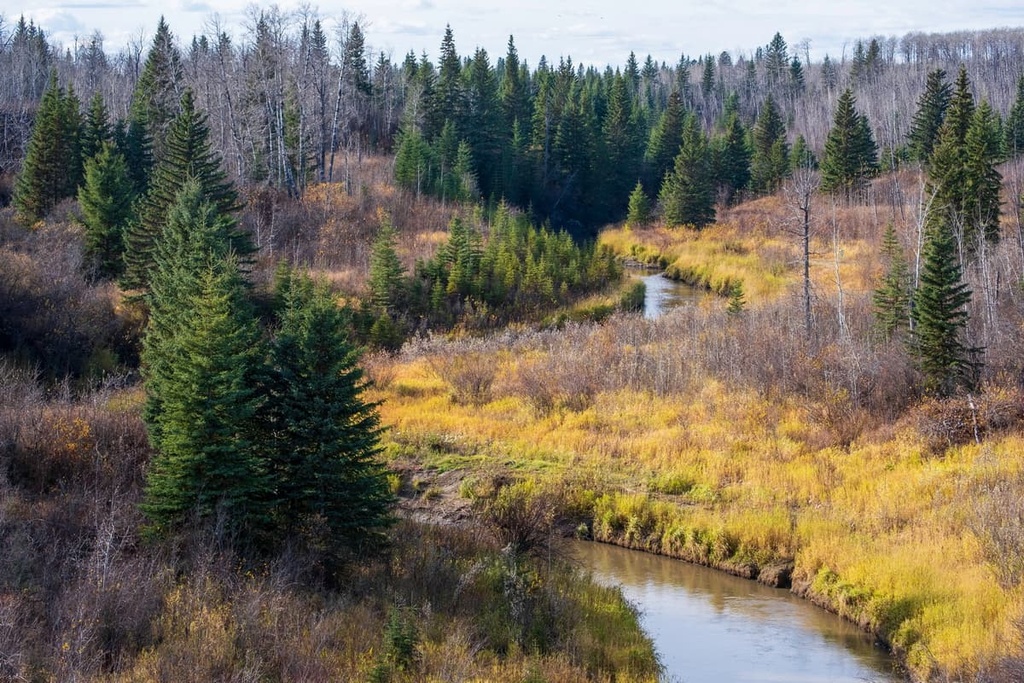
The plants and animals of Birch Hills County are mainly representative of the Dry Mixedwood subregion of the Boreal Forest Natural Region. The subregion is the second largest natural subregion in Alberta and the forests of Birch Hills County are among the northernmost representations of this ecology.
The Dry Mixedwood subregion is the warmest of the Boreal subregions and it has the longest growing season. Wetlands commonly occur in low-lying areas and forests of aspen, poplar, jack pine, and white spruce cover the uncultivated areas of the region. About 50 percent of the area has been converted into agricultural cropland that grows annual and forage crops.
The aspen forests in the region have a shrubby understory of rose, beaked hazelnut, low-bush cranberry, and Canada buffaloberry, which is unique to the aspen forests around the Peace River.
Meanwhile, balsam poplar forests dominate the moist sites in the region and typically have a shrub layer of red-osier dogwood. The dry sites throughout the Birch Hills are dominated by Jack pine forests and they have an understory of blueberry and lichen.
As far as wildlife goes, around the county’s wetlands, you may encounter yellow warblers, American redstarts, song sparrows, northern waterthrush, and fox sparrows. Other bird species in the county include the yellow-bellied sapsucker, Swainson’s thrush, solitary vireo, and the magnolia warbler.
The most common wildlife species in the county are the red squirrel, snowshoe hare, cinereus shrew, southern red-backed vole, least chipmunk, deer mouse, and ermine. Black bears and moose are the most common large mammals in the county. Other mammals that you might see include beavers, fishers, wolverines, river otters, Canada lynx, and gray wolves.
Since the nineteenth century, the rich soils of the Peace River region and Birch Hills County have been known for producing wheat crops; however, Indigenous peoples have lived in the area for thousands of years, long before the arrival of the contemporary agricultural industry.
Birch Hills County is the traditional territory of the Dane-zaa First Nations, who were called the Beaver by the Europeans and the Cree.
Archaeological evidence found southwest of Birch Hills County on Saskatoon Mountain suggests human habitation of the region began over 9,000 years ago. The glaciers of the Pleistocene had mostly melted from the region 12,000 years ago; however, the glacial Peace Lake covered most of the region for subsequent millenia.
Within the Birch Hills, archaeologists have uncovered many projectile points. Most of the projectile points are thought to have been made within the last couple thousand years.
Before the arrival of fur traders, the Dane-zaa traditionally lived within the forests and along the rivers of the Peace Region. However, as the fur trade pushed west, the Cree, who were often guides and intermediaries for European fur traders, displaced the Dane-zaa First Nations. Before the traders arrived, decades of hostilities finally ended in 1781 when a smallpox epidemic decimated the Cree First Nations.
Many Cree who moved to the region had firearms acquired from the fur traders. This allowed them to displace the Dane-zaa who traditionally lived to the south of the Peace River. Finally, in 1781, The Treaty of the Peace was celebrated by the smoking of a peace pipe. It made the Peace River a border that demarcated the territory of the Dane Zaa to the north and the Cree to the south.
Nowadays, the county is economically dependent on the agriculture, oil, and gas industries. Most of the county’s approximately 1,600 residents work in one of these sectors.
The trails of Birch Hills County take you along clear creeks and through stunning boreal forest. The following are some trails and hiking areas in Birch Hills County that you can check out if you visit the area:
The Bronco Creek Trail is a 4 km (2.4 mi) out-and-back trail with minimal elevation gain. The trail is used for hiking in the summer and snowshoeing in the winter. As per the locals, one of the highlights of this trail is that there is no cell service, making it a great place to escape to.
Peace River Wildland Provincial Park is a series of protected areas that border the Peace and Smoky Rivers in Birch Hill County. The park includes a backcountry campground, and while there are many unofficial trails, it is frequently visited by paddling enthusiasts. A popular paddling trip in the park leads from the community of Peace River and ends 25 km (15 mi) away at Murphy Flats.
There are no cities, towns, or even village-level municipalities in Birch Hills County; however, there are several larger communities and cities near the county that serve as great launching points for outdoor adventures.
Located just to the northeast of Birch Hills County near the confluence of the Peace and Smoky Rivers, the community of Peace River has over four times the population of the entire Birch Hills County. The contemporary history of the city dates back to 1792, when Alexander Mackenzie established Fort Fork to the southwest of the present community.
Some of the attractions in the community include the Peace River Museum, which houses over 10,000 artifacts pertaining to local First Nations and the fur trade. There’s also the Lac Cardinal Pioneer Village Museum and Mile 0 Antique Track Museum that are both worth checking out.
Some areas to walk and hike around the city include Riverfront Park, Normand Boucher Community Arboretum, Greene Valley Provincial Park, and Pat’s Creek Trail.
Grande Prairie is located about 100 km (60 mi) to the southwest of Birch Hills County. It is the seventh largest city in Alberta with over 60,000 residents.

Until the 1950s, Grande Prairie competed with the nearby communities of Dawson Creek and Peace River as the most important city in the region, at which point oil and gas exploration led to a dramatic increase in the city’s population, making it much larger than other nearby communities.
Some of the popular local parks and hiking areas around Grand Prairie include Muskoseepi Park and Crystal Lake. The city has traditional and disc golf courses, as well as a local ski hill.
Saskatoon Mountain Natural Area, which features a number of archaeological sites, is situated just to the west of the city. The vast wilderness of the Far Northern Rockies is also located only 200 km (120 mi) to the west of the Grande Prairie.


