
Scan the QR code and open PeakVisor on your phone
The Beaufort Range is a collection of peaks located on the eastern side of Vancouver Island in the province of British Columbia, Canada. Stretching from Horne Lake to Comox Lake, the range has 16 named peaks and a trail that connects 8 of them for an incredible adventure. The tallest of the mountains in the range and the highlight of the trail is Mount Joan, which stands at 1,556 m (5,105 ft) tall with 1,129 m (3,704 ft) of prominence.
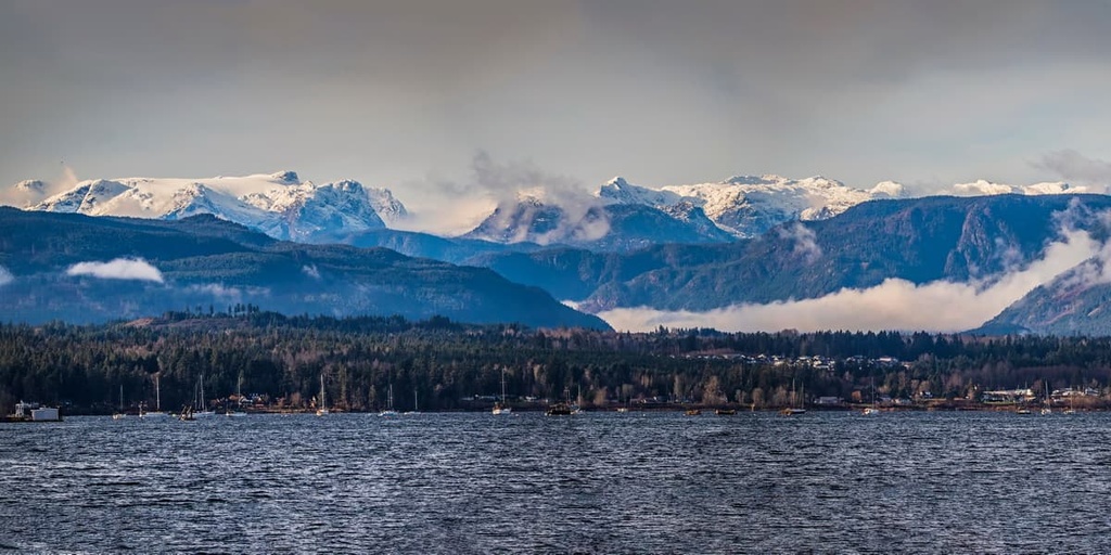
Located along the east coast of Vancouver Island in British Columbia, Canada, the Beaufort Range straddles the border of the Comox Valley Regional District and the Regional District of Nanaimo. The range stretches from Horne Lake to Comox Lake and has 18 named peaks.
The tallest of the peaks is Mount Joan, which is 1,556 m (5,105 ft) high and has 1,129 m (3,704 ft) of prominence. Mount Joan is the highlight of a trail through the range that summits up to ten of the range’s peaks.
The Beaufort Range is accessible from Highway 19, which runs along the east coast of Vancouver Island from Nanaimo to Port Hardy, on the north end of the island. Horne Lake Caves Provincial Park is an incredible park that is located at the south end of the Beaufort Range that features karst caves and other limestone formations.
Other parks that are located near the Beaufort Range include:

The basic geology of the Beaufort Range is similar to all the Vancouver Island Ranges, which are a subrange of the Insular Mountains. The Vancouver Island Ranges are generally composed of rocks from an ancient terrane called Wrangellia.
Wrangellia started forming over 300 million years ago when undersea volcanoes erupted and created a layer of lava across the sea floor. For over 100 million years, marine sediment accumulated upon the lava, until 230 million years ago, when another series of eruptions that lasted 5 million years added a layer of lava that was about 6 km (3.6 mi) thick.
The eruptions from 230 million years ago added so much material to the terrane that islands formed upon the ocean. Over the following 130 million years, Wrangellia moved east and was on a collision course with the westward moving North America. As the tectonic plate that Wrangellia formed on was subducted beneath North America, the relatively buoyant volcanic islands accreted to the edge of the continent.
In the east, the collision of Wrangellia with North America compressed the continental margin and caused the uplift of the Canadian Rockies. The collision also caused the Wrangellia terrane to compress, buckle, fold, and in some places Wrangellia broke apart and crumbled, creating Vancouver Island and her mountain ranges in the process.
However, the formation of Vancouver Island and the mountains that tower above it were not yet finished. Additional outboard terranes collided with Vancouver Island, which caused further uplifting the mountains and compression of the continental margin. The collisions broke the structure of the island as it created many faults.

One of the major faults is the Beaufort Range Fault Zone, which runs along the eastern edge of Vancouver Island. The Beaufort Range Fault Zone is responsible for the Comox Uplift, which is part of the Beaufort Range itself. The Cowichan Uplift is an area of exposed Paleozoic rocks from the Sicker group of rocks.
The Sicker group is composed of sedimentary and pyroclastic rocks that have been folded into tight isoclinal folds. In addition to some limestone, the group has massive volcanic and intrusive rocks that were deformed and generally converted to quartz-mica and chlorite-epidote schists. In other words, the Beaufort Range is composed of sandstones, shale, basaltic intrusions, and limestone.
The ecology of the Beaufort Range represents the full extent of Vancouver Island’s mountain ecology. The alpine is representative of the Coastal Mountain-Heather Alpine ecology, while the subalpine is part of the Mountain Hemlock ecology, and the valleys are part of the Coastal Western Hemlock ecology.
The range contains a diverse mountain ecology with rocky peaks that are covered with communities of mountain heather and old growth forests that are found along the slopes and in the valleys.
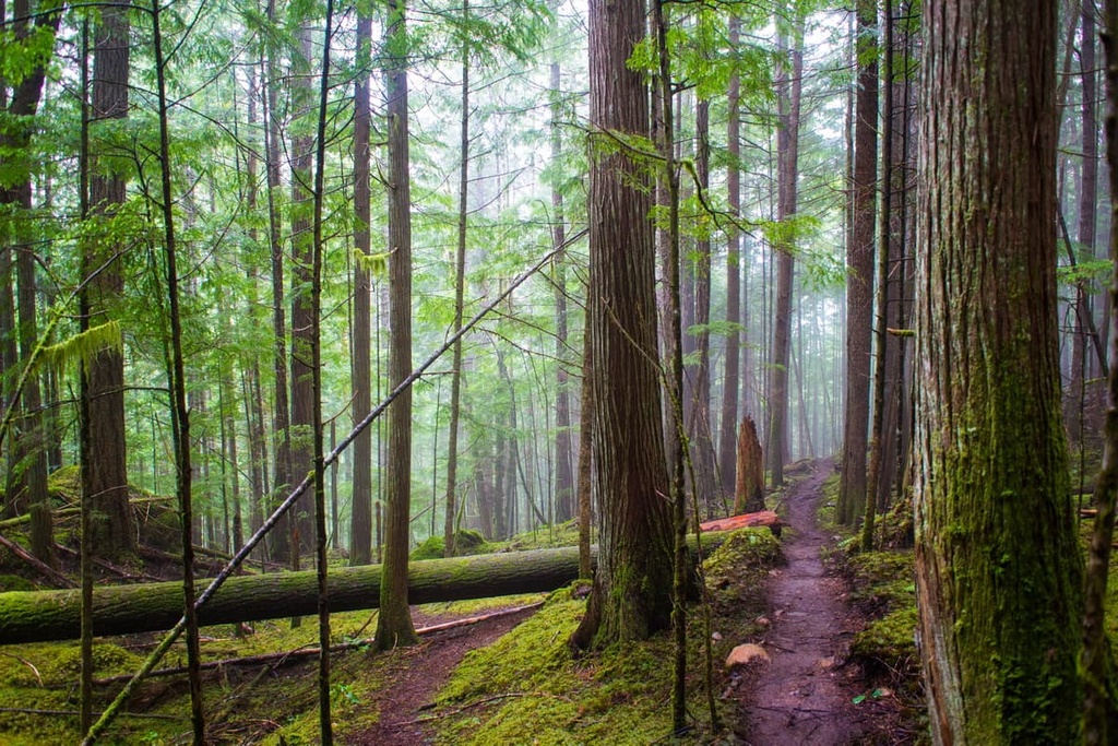
The upper elevations of the range consist of old growth forests of mountain hemlock, Pacific silver fir, and yellow cedar. The valleys, lake shore, and the areas along the creeks in the range are filled with massive Douglas fir, western red cedar, big leaf maple, and alder.
Black bears, Columbian black-tailed deer, Roosevelt elk, cougars, and wolves roam the slopes and valleys. Eagles, falcons, and ravens fly over the range along with many other bird species that inhabit the forests of the Beaufort Range. Additionally, the lakes at either end of the range are home to many different waterfowl and fish species.
Archeological evidence suggests that Vancouver Island has been inhabited for at least the past 13,000 years. The Beaufort Range is in the traditional territory of the K’ómoks and We Wai Kai First Nations.
Before it was called the Beaufort Range, the First Nations of the region called the range Yuts-whol-aht, which means “walking through the face of the mountains.” This name refers to the trade route through the range that traditionally ran from Port Alberni to the Comox Valley.

The region had rich resources that helped support local First Nations for countless generations. Many First Nations in the area historically relied on fishing for their main sustenance. For over 1,200 years the locals of the Beaufort Range built fishing weirs on the east side of the range in the harbor. These rich resources were the cause of many battles between First Nations for control of the fishing areas.
While there were frequent and bloody battles fought for the resources of the Beaufort Range and adjacent ocean, the epidemics that European settlers brought with them were truly devastating to First Nations in the area.
For example, there were an estimated 30,000 Indigenous people living along the east coast of Vancouver Island before the smallpox epidemic of 1862. It is estimated that the epidemic of 1862 killed over half of the Indigenous people who lived on the eastern shores of Vancouver Island. The deaths caused by the epidemics and the continuing arrival of settlers into the fertile Comox Valley changes the lives of local First Nations forever.
While it was a major part of the trans-island trade route and was called Yuts-whol-aht before colonization, the Beaufort Range and its peaks are now all called by their new English names. The peaks in the range are all named for prominent people who lived in the area; however, it is arguable that the First Nations history of the region before the arrival of settlers has been greatly overlooked in the naming of these mountains.

Stretching from Comox Lake to Horne Lake, the Beaufort Range is a relatively small collection of peaks; however, there are many great trails and attractions within the range that are worth looking into. Here are some of the major trails and attractions of the Beaufort Range that are worth checking out.
The official high-level traverse of the Beaufort Range is a multi day expedition that follows the spine of the range. The route typically starts toward the north end of the range on the slopes of Mount Clifton and ends after summiting Mount Joan.
Officially, the route summits Mount Clifton, Tsable Mountain, Mount Stubbs, Mount Henry Spencer, Mount Cameron, Mount Apps, The Squarehead, and Mount Joan. Unofficially, ambitious hikers can attempt to add Mount Chief Frank, Mount Hal, Mount Irwin, and several other unnamed peaks to the trek.
The “Haute Route” is a difficult trek; however, it is an incredible hiking opportunity that takes you along the spine of the range. The local hiking clubs organize hikes along all or part of the route.

As the tallest peak in the range, Mount Joan offers a spectacular view from the summit. The 15 km (9 mi) out and back trail is accessible via forest roads and has 1,125 m (3,690 ft) of elevation gain if you have a capable, high clearance 4x4 vehicle. Regular cars may need to park further away, which adds 4 km (2.4 mi) each way and 420 m (1,377 ft) of elevation gain to the overall journey.
The hike is considered difficult; however, the view from the summit is spectacular. On a clear day, hikers can easily see the Coast Mountains on the mainland and the intervening Georgia Strait.
Mount Mark and Mount Apps are among the most popular peaks to summit in the Beaufort Range. Mount Mark is a difficult, steep hike that overlooks Horne Lake and has views of the Alberni Inlet while Mount Apps involves a moderate hike that follows the ridgeline to the final summit.
Both trails are about 9 km (5.4 mi) long; however, the Mount Mark trailhead is much easier to get to. As with many trails in the Vancouver Island Ranges, 4x4 vehicles can get hikers closer to the official trailheads, as the forestry roads are not always in good or passable condition.
The Horne Lake Caves Provincial Park is a small park on the north shore of Horne Lake. The park encompasses the southern slopes of the Beaufort Range where karst caves and formations were first documented by settlers in 1912.

Local caving enthusiasts saw a need to protect these caves and a park was formed in 1971 to help preserve the delicate formations and ecosystems. There are many caves available for self-exploration as well as some that are only accessible through a guided tour.
Some of the main features of the park are the 400 m (1,312 ft) long Riverbend Cave as well as the Main Cave. The main cave has Canada’s only cave slide, and the guided tours also offer the opportunity to climb an underground waterfall, rappel down a seven-story waterfall, and many more unique experiences.
The park has a visitor info center where guests can rent spelunking gear to go self-exploring or to join up with a guided tour. The interpretive trail between the caves is also a wonderful hike for those who do not wish to venture into the caves, and it is a fascinating place to spend a day or two.
The Beaufort Range is located along the populated east coast of Vancouver Island. The following are some of the major cities near the range where you can find food, supplies, and accommodations.
The cities of Courtenay, Comox, and Cumberland are the central municipalities of the Comox Valley, and they are located upon the eastern slopes of the Beaufort Range. The three communities form the primary commercial and residential area of the valley where the original European settlers paid only $1 per acre for the land in the Comox Valley in 1862.
While Courtenay and Cumberland were developed through industries such as fishing, mining, and forestry, Comox grew slowly and was a vacation town that offered golf, dining, fishing, hunting, tennis, and more to the affluent visitors. With the beautiful beaches along the coast as well as clear lakes, rivers full of salmon, and an incredible wilderness just outside of town, tourism has grown significantly.

Some of the attractions and trails worth checking out in the area include the Seal Bay Nature Park, the Rosewall Creek Trail, Trent Falls, and Helliwell Provincial Park Loop. Strathcona Provincial Park, Horne Lake Caves Provincial Park, and the Mount Arrowsmith Massif Regional Park are some of the nearby hiking areas.
The city of Nanaimo is situated about 70 km (42mi) to the south of the Beaufort Range and it is one of the primary ports for ferries bringing passengers from mainland British Columbia. While Nanaimo is famous for the culinary delight, the Nanaimo Bar, there are also many fantastic trails in the area for hiking and mountain biking that are worth checking out.
After tasting the Nanaimo Bar, visitors may want to look for Gordie’s Trail up Mount Benson, the Mount Benson Loop, Westwood Lake Trail, and the Cable Bay Nature Trail. Other places to check out from Nanimo are Rathtrevor Beach Provincial Park, Englishman River Falls Provincial Park, and Westwood Lake Park.

Located at the head of the Alberni Inlet, Port Alberni is a city situated on tidal waters on the west coast of Vancouver Island along the western slopes of the Beaufort Range. The city is home to one of British Columbia’s first sawmills, so forestry has long been the primary employer in the region.
While Port Alberni is still economically dependent upon logging and milling, environmentally friendly tourism is gaining traction as a major employer in the region. Offering marine and freshwater fishing, hiking, kayaking, and mountain biking, Port Alberni is a good jumping off point for many outdoor activities.
There are several hiking trails in Port Alberni and over a hundred in the surrounding valley and mountains. The Horne Lake Trail, Log Train Trail, and the Inlet Trail are all popular trails in the area. Mount Arrowsmith is also located nearby, so you can hike the Saddle Trail or climb to the summit. From the town, you can also access the western slopes of the Beaufort Range and the trailheads that lead to the summits of Mount Clifton, Mount Apps, and Mount Irwin.


