The Karlspitzen is a twin-peaked mountain in the middle of the Kaisergebirge range of the Northern Limestone Alps in Austria. The two peaks are the northern Hintere Karlspitze (2,281 m) and the southern Vordere Karlspitze (2,263 m) with its summit cross; they are linked by a sharp, exposed, rocky arête. Seen from the south the Vordere Karlspitze is a huge and very prominent block of rock, whereas the Hintere Karlspitze is hidden behind other (lower) neighbouring mountains.
There's an alpine trail (T4) leading to the summit.
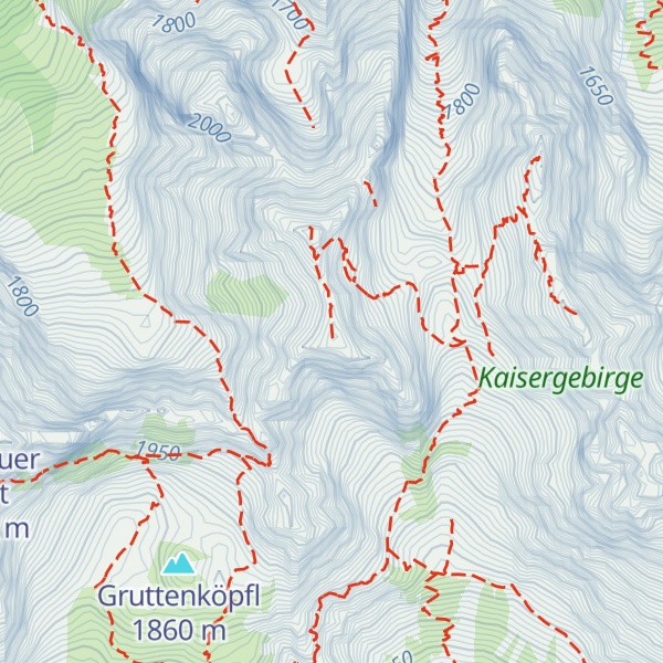
The nearest mountain hut is Babenstuberhütte located 1 100m/3 610ft W of the summit.
By elevation Vordere Karlspitze is
# 10 out of 108 in Kaisergebirge (Naturschutzgebiet) # 11 out of 320 in Bezirk Kufstein # 10 out of 93 in the Wilder Kaiser # 10 out of 149 in the Kaisergebirge
By prominence Vordere Karlspitze is
# 15 out of 108 in Kaisergebirge (Naturschutzgebiet) # 50 out of 320 in Bezirk Kufstein # 14 out of 93 in the Wilder Kaiser # 19 out of 149 in the Kaisergebirge
We use GPS information embedded into the photo when it is available.
3D mountains overlay
Adjust mountain panorama to perfectly match your photos because recorded by camera photo position might be imprecise.
Move tool
Rotate tool
Zoom
More customization
Choose which peak labels should make into the final photo and what photo title should be.
Next
Photo Location
Satellitte
Flat map
Relief map
Latitude
Longitude
Altitude
OR
Latitude
°'''
Longitude
°'''
Apply
Register Peak
Peak Name
Latitude
Longitude
Altitude
Register
Teleport
PeakVisor
This 3D model of Sagarmatha National Park in Nepal was made using the PeakVisor app topographic data. The mobile app features higher precision models worldwide, more topographic details, and works offline. Download PeakVisor maps today.
Download OBJ model
PeakVisor
The download should start shortly. If you find it useful please consider supporting the PeakVisor app.
PeakVisor for iOS and Android
Be a superhero of outdoor navigation with state-of-the-art 3D maps and mountain identification in the palm of your hand!