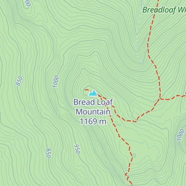
Bread Loaf Mountain is a mountain located in Addison County, Vermont, in the Breadloaf Wilderness in the Green Mountain National Forest. The mountain is part of the central Green Mountains. Bread Loaf Mountain is flanked to the northeast by Mount Wilson, part of Vermont's Presidential Range.
The southeast end of Bread Loaf Mountain drains into the headwaters of the White River, thence into the Connecticut River which drains into Long Island Sound in Connecticut. The east side of Bread Loaf Mountain drains into the headwaters of the New Haven River, thence into Otter Creek, Lake Champlain, Canada's Richelieu River, the Saint Lawrence River, and ultimately into the Gulf of Saint Lawrence.
The northern part of the west side of Bread Loaf Mountain drains into Blue Bank Brook, thence into the New Haven River. The southern part of the west side of Bread Loaf Mountain drains into Sparks Brook and the Middle Branch of the Middlebury River, thence into the Middlebury River at Ripton and Otter Creek.
The Long Trail, a 272-mile (438 km) hiking trail running the length of Vermont, crosses the southeastern flank of Bread Loaf Mountain. The actual summit is reached by a spur path from the Long Trail that leads northwest to an outlook. This section of the Long Trail may be accessed in various ways: via the Skyline Pond Trail off USFS 59 (Steam Mill Road), via the Clark Brook Trail off USFS 55, or via the Emily Proctor Trail off USFS 201.
There's a trail called Long Trail leading to the summit. Bread Loaf Mountain is one of the 53 peaks along the multi-day Long Trail.
By elevation Bread Loaf Mountain is
# 1 out of 13 in Breadloaf Wilderness # 20 out of 1311 in Vermont # 3 out of 102 in Addison County # 19 out of 683 in the Green Mountains
By prominence Bread Loaf Mountain is
# 1 out of 13 in Breadloaf Wilderness # 30 out of 1311 in Vermont # 2 out of 102 in Addison County # 19 out of 683 in the Green Mountains
We use GPS information embedded into the photo when it is available.
3D mountains overlay
Adjust mountain panorama to perfectly match your photos because recorded by camera photo position might be imprecise.
Move tool
Rotate tool
Zoom
More customization
Choose which peak labels should make into the final photo and what photo title should be.
Next
Photo Location
Satellitte
Flat map
Relief map
Latitude
Longitude
Altitude
OR
Latitude
°'''
Longitude
°'''
Apply
Register Peak
Peak Name
Latitude
Longitude
Altitude
Register
Teleport
PeakVisor
This 3D model of Sagarmatha National Park in Nepal was made using the PeakVisor app topographic data. The mobile app features higher precision models worldwide, more topographic details, and works offline. Download PeakVisor maps today.
Download OBJ model
PeakVisor
The download should start shortly. If you find it useful please consider supporting the PeakVisor app.
PeakVisor for iOS and Android
Be a superhero of outdoor navigation with state-of-the-art 3D maps and mountain identification in the palm of your hand!