Available for connected Garmin and Suunto accounts.
Scan the QR code and open PeakVisor on your phone
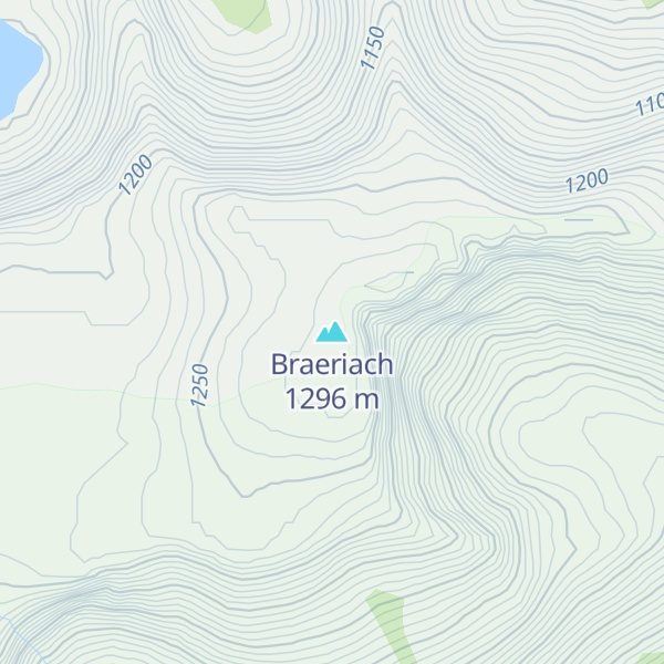
Braeriach map
Braeriach
Be the first photographer!
1 296 m
Elevation
Elevation is the altitude of a place above sea level.
462 m
Prominence
Peak’s prominence is the least vertical to be covered to get from the summit to any other higher terrain.
Proportional Prominence1 257 m
TGO40
The Great Outdoors Britain's 40 Finest Mountains.
Munro
Mountains in Scotland with a height of over 914 m / 3 000 ft bear a special name, the Munros. They are named after Sir Hugh Munro, the 4th Baronet (1856–1919), who produced the first list of such hills, known as Munro’s Tables, in 1891.
Braeriach or Brae Riach (Scottish Gaelic: Am Bràigh Riabhach, 'the brindled upland') is the third-highest mountain in Scotland and all of the British Isles, after Ben Nevis and Ben Macdui, rising 1,296 metres (4,252 ft) above sea level. It is in the Scottish Highlands and is the highest point in the western massif of the Cairngorms, separated from the central section by the Lairig Ghru pass. The summit is a crescent-shaped plateau, overlooking several corries.
Probably the most commonly used route up Braeriach starts from Sugar Bowl car park, on the road leading to the Cairn Gorm ski area. From here a path leads over the hillside to a steep-sided rocky ravine known as the Chalamain Gap, before descending around 100 metres (330 ft) to the Lairig Ghru. After crossing this pass the route heads for the summit via Braeriach's north ridge, crossing a subsidiary peak, Sròn na Lairige. The summit is about 9 km (5.6 mi) from the car park by this route.
There's a trail leading to the summit.
By elevation Braeriach is
# 2 out of 4967 in Highland # 2 out of 1430 in Aberdeenshire # 3 out of 18277 in Scotland # 3 out of 34760 in United Kingdom # 2 out of 63 in Mar Lodge Estate National Nature Reserve # 2 out of 1071 in Cairngorms National Park # 3 out of 5485 in the Grampian Mountains
By prominence Braeriach is
# 3 out of 1430 in Aberdeenshire # 2 out of 63 in Mar Lodge Estate National Nature Reserve # 7 out of 1071 in Cairngorms National Park # 66 out of 5485 in the Grampian Mountains
We use GPS information embedded into the photo when it is available.
3D mountains overlay
Adjust mountain panorama to perfectly match your photos because recorded by camera photo position might be imprecise.
Move tool
Rotate tool
Zoom
More customization
Choose which peak labels should make into the final photo and what photo title should be.
Next
Photo Location
Satellitte
Flat map
Relief map
Latitude
Longitude
Altitude
OR
Latitude
°'''
Longitude
°'''
Apply
Register Peak
Peak Name
Latitude
Longitude
Altitude
Register
Teleport
PeakVisor
This 3D model of Sagarmatha National Park in Nepal was made using the PeakVisor app topographic data. The mobile app features higher precision models worldwide, more topographic details, and works offline. Download PeakVisor maps today.
Download OBJ model
PeakVisor
The download should start shortly. If you find it useful please consider supporting the PeakVisor app.
PeakVisor for iOS and Android
Be a superhero of outdoor navigation with state-of-the-art 3D maps and mountain identification in the palm of your hand!