Scan the QR code and open PeakVisor on your phone
The Twin Peaks Wilderness is a federally protected area situated along the southern side of the Salt Lake Valley in the north-central part of the US state of Utah. The tallest and most prominent peak in the wilderness is Twin Peaks at 11,332 ft (3,454 m) in elevation and with 1,440 ft (439 m) of prominence.
The Twin Peaks Wilderness is a small protected region situated to the southeast of Salt Lake City, Utah. The wilderness encompasses 11,396 acres (4,612 ha) of land within the Uinta-Wasatch-Cache National Forest.
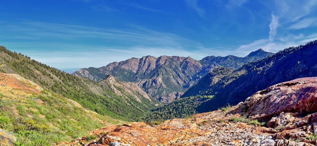
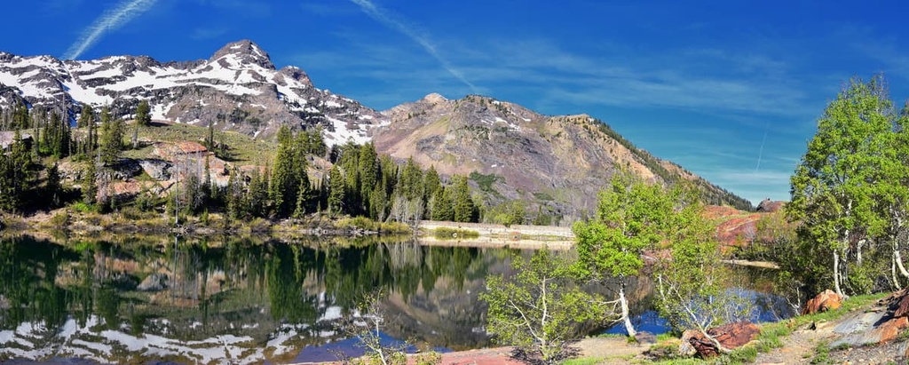
Rugged ridges and narrow canyons dominate this scenic part of the Salt Lake Valley. Within the wilderness, high peaks tower above glacial cirques and alpine meadows, adding to the dramatic landscape.
Elevations in Twin Peaks range from around 5,000 feet (1,520 m) up to the summit of Twin Peaks. The higher elevations within the wilderness are classified as alpine and they feature many exposed ridges.
Along with dramatic changes in elevation the Twin Peaks Wilderness can feature sizable changes in temperature throughout its borders at any given time. This is particularly true when large snow patches persist until midsummer, dragging down the local temperature in the process.
Lower elevations in the wilderness are home to patches of forests, rushing creeks, and more gradual changes in elevation. Big Cottonwood Creek marks the northern boundary of the wilderness while Little Cottonwood Creek marks the southern boundary.
The Twin Peaks Wilderness lies within the Uinta-Wasatch-Cache National Forest. It is surrounded by various other wilderness areas. Directly to the north lies Mount Olympus Wilderness while the Lone Peak Wilderness lies directly to the south. Other nearby protected areas include Wasatch Mountain State Park, Mount Timpanogos Wilderness, and Jordanelle State Park.
The Twin Peaks Wilderness is part of the Wasatch Range within the Uinta-Wasatch-Cache National Forest. The Wasatch Range runs from north to south through central Utah, and it is part of the greater Rocky Mountains.
The range lies along a normal fault that separates the rest of the Rocky Mountains to the east and the Great Basin Ranges to the west.
The Wasatch Range, including the landscape in the wilderness, began forming between 12 to 17 million years ago. Situated along the Wasatch Fault, the peaks were created by immense pressure that deformed the Earth’s crust.
Continual thrusting forced large sections of rock on top of one another, forming a jagged range. This initial range was then heavily eroded away, exposing older layers of sedimentary rock in the process.
The large cirques in the wilderness were carved out by glaciers during the last glacial maximum. Today, erosion continues to further shape the rugged landscape. Geologic structures found in the wilderness include sedimentary formations along with granitoid masses of rock.

Major peaks within the Twin Peaks Wilderness include Twin Peaks, Sunrise Peak, Monte Cristo, Dromedary Peak, Sundial Peak, and Storm Mountain.
The flora and fauna found within the Twin Peaks Wilderness is similar to much of the Uinta-Wasatch-Cache National Forest.
The higher elevation terrain in the wilderness is classified as alpine. Flora at these elevations consists of scattered patches of trees, grasses and sagebrush. Aspen and fir trees are found in small patches, primarily on north facing slopes.
Lower elevations are populated by dense patches of oak and maple trees along with various grasses. Wildflowers can be seen during the summer months, particularly in the alpine parts of the wilderness area.
Wildlife in this region of the Wasatch Range is often quite limited since the wilderness is bordered by highways and cities. However, hikers may be able to spot mule deer, mountain lions, weasels, black bears, mountain goats, and coyotes during their visit to the region.

The region in and surrounding the Twin Peaks Wilderness has been inhabited by humans for thousands of years. Some of the earliest artefacts in the region date back over 10,000 years.
The land has been home to many Indigneous peoples throughout its long and rich history. More specifically, the land is part of the traditional territory of the Shoshone, Weber Ute, and Paiute.
The Ute traditionally lived in the region as hunters and gatherers. Traditionally, many Ute bands lived in the lower elevations of the region and traveled to the mountains to find food and resources.
Settlers of European descent began arriving in the region during the early 1800s. During this time, Brigham Young sent a group of Mormon missionaries to settle in the region. Many of these initial settlements would later become the larger cities of northern Utah that are still present today.
Disputes broke out frequently between Tribal Nations and US settlers as both groups fought for their right to live on the land. In 1863, US troops attacked a group of Shoshone, killing hundreds of tribal members in what would later be known as the Bear River Massacre.
Following the massacre, the Shoshone united with the Bannock in the hopes of reclaiming their ancestral homelands. The Snake War followed shortly thereafter, resulting in the forcible removal of the Shoshone and Bannock to a reservation in Idaho by US troops.

Subsequently, the populations of the region’s cities continued to grow as fur trappers, missionaries, railroad workers, and miners settled in the region. Today, the Salt Lake region is the most populous area in the entire state.
The Uinta-Wasatch-Cache National Forest was established in 1906. The Twin Peaks Wilderness was established in 1984, following the passage of the Utah Wilderness Act.
The Twin Peaks Wilderness is home to numerous hiking trails. Here are some of the most popular hiking areas in the region:
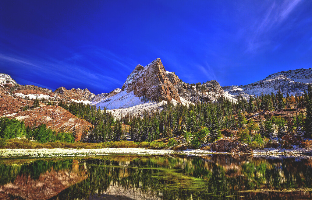
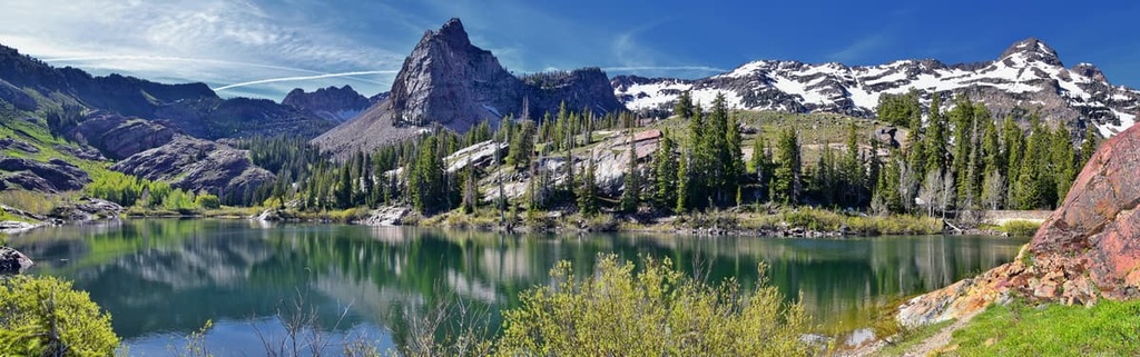
The Lake Blanche Trail is easily the most popular hiking route within the wilderness. The trail is 6.8 miles (11 km) long round trip with 2,808 ft (856 m) of elevation gain. The trail starts along the Big Cottonwood Canyon, and follows along the creek before climbing into the mountains.
Switchbacks take hikers through forested areas that feature mountain views throughout. Lake Blanche is an alpine lake, surrounded by grassy slopes, rugged ridgelines, and trees. During this adventure, hikers are also treated to views of Lake Florence and Lake Lillian.
Before arriving at the summit, hikers also have views of parts of Salt Lake City down below.
The Broads Fork Trail is 4.5 miles (7.2 km) long round trip with 2,109 ft (643 m) of elevation gain. The trail follows along a rushing creek as it climbs through the rugged mountain range. Small patches of trees along the way also provide hikers with more shade coverage than what you get on most of the other hiking trails in the region.
As the trail continues to climb, views of the Wasatch Range become visible in the distance. The route experiences less traffic than nearby hikes, allowing for solitude within the wilderness and better chances of spotting wildlife.
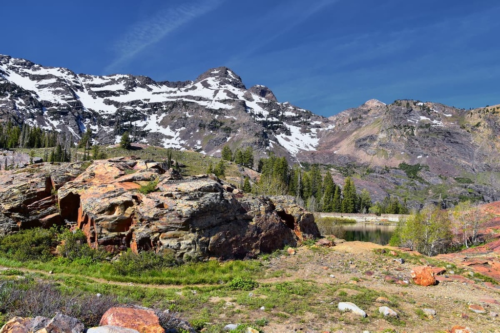
The hike to the Ferguson Canyon View Point is one of the shorter routes within the wilderness. The trail is 3.2 miles (5.1 km) long with 1,459 ft (445 m) of elevation gain.
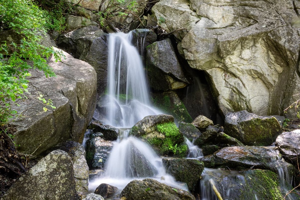
After following along a dirt road, the trail passes through forested patches featuring small waterfalls. After the waterfalls, the trail continues to climb up to the overlook. From the rock outcropping, hikers have impeccable views of the Salt Lake Valley.
Looking for a place to stay near Twin Peaks Wilderness? Here are some of the best cities and villages to check out in the region:
Salt Lake City is the closest major city to the Twin Peaks Wilderness. The city is situated to the northwest of the wilderness and lies along the southeastern shores of Great Salt Lake. Though the city is home to around 200,000 people, it has a metro population of over 1.2 million, making it the most populous region in the state.
The city is a hub for mountain based activities, and it is surrounded by hundreds of miles of trails. During the summer months, common activities include mountain biking, hiking, trail running, and backpacking. The Uinta-Wasatch-Cache National Forest and Ashely National Forest both lie just east of the city, and five major national parks are also located within close proximity of the metro area.

Salt Lake City is also a popular destination during the winter due to its multitude of ski resorts.
The city boasts nine resorts within an hour’s drive, along with plentiful cross country skiing and snowshoe trails.
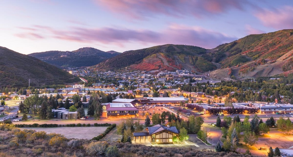
Park City lies just to the east of the wilderness. It is home to around 8,500 people. Two major ski resorts lie within the city—Deer Valley Resort and Park City Mountain Resort. During the winter, the number of tourists flocking to these resorts often exceeds the city’s population.
During the summer, the city boasts ample opportunities for trail running, hiking, mountain biking, and backpacking. Besides outdoor activities, Park City is also the main location for the Sundance Film Festival, one of the largest independent film festivals in the country. It also acts as the homebase for the United States National Ski Team.
The downtown region of Park City is also home to fine dining restaurants, local breweries, and artisan shops that are well worth checking out.