
Scan the QR code and open PeakVisor on your phone
The Ten Lakes Wilderness Study Area (WSA) is located in the northwestern corner of the US state of Montana. The stunning terrain is marked by rugged ridgelines, alpine lakes, and forested hillsides. The tallest and most prominent in the WSA is Green Mountain at 7,822 feet (2,384 m) tall with 1,614 feet (492 m) of prominence.
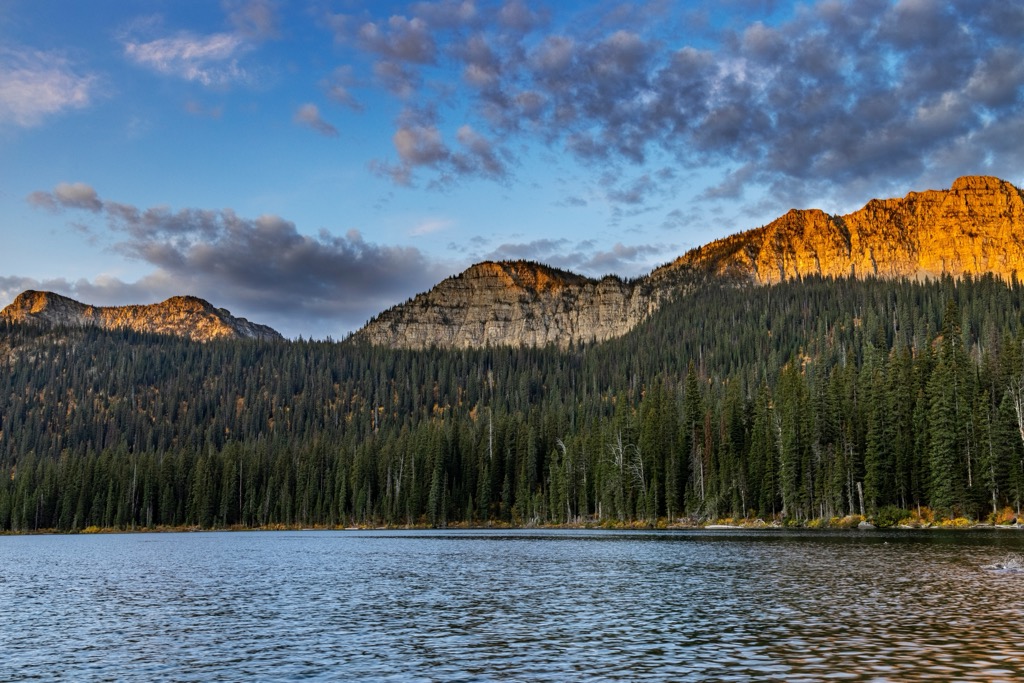
The Ten Lakes Wilderness Study Area is located in northwestern Montana, within the Kootenai National Forest. This WSA spans roughly 34,000 acres (13,759 ha) across the alpine terrain, marking one of the most stunning landscapes in the region.
Within the Ten Lakes WSA lies the Ten Lake Scenic Area, spanning 14,945 acres (6,048 ha). The protected region is named after the Ten Lakes Basin which features numerous alpine lakes nestled within glacial cirques.
Terrain is marked by the rugged Whitefish Mountains which feature dramatic changes in elevation. Massive ridgelines tower above the pristine lakes while the hillsides are marked by a mixture of forested patches, scree fields, and alpine meadows.
Situated in the northeastern section of Kootenai National Forest, the WSA lies directly south of the US-Canada border. The Kootenai River lies just west of the WSA, while Glen Lake is located to the south.
Various creeks and streams cut through the mountainous landscape, fed by the snowpack in the region. Some of the prominent bodies of water include Bluebird Creek, Wolverine Creek, Sinclair Creek, Blacktail Creek, and Indian Creek.
Besides the fact that the WSA is located within the Kootenai National Forest, the Ten Lakes WSA is also surrounded by other parks and forests. To the east lies Glacier National Park and Flathead National Forest while the Kootenai Woods Ranch Wildlife Management Area is to the west. Vast sections of both Kootenai and Flathead National Forests extend to the southwest, south, and southeast.
The peaks within the Ten Lakes WSA are part of the Whitefish Range which span from the US-Canada border in a north to south direction. The range spans 76 miles (122 km) in length and 58 miles (93 km) in width.
The rugged Whitefish Range is part of the Northern Rocky Mountains, a subrange of the vast Rocky Mountain range. Tens of millions of years ago, the Rocky Mountains slowly began forming.
Geological history of the region dates back to the Proterozoic Eon. Rocks from this period are not found in many other places in the world but are part of the Belt Supergroup in this portion of the Rocky Mountains.
Roughly 150 million years ago, tectonic plates collided along the west coast of North America. During the Sevier Orogeny, this collision led to layers of rock being thrust upwards. The range was further thrust upwards during the Laramide Orogeny. Over the course of millions of years, rock layers from the Paleozoic, Mesozoic, and Cenozoic were eroded and are no longer present in much of the region.

Widespread glaciation during the last glacial maximum has helped shape the Ten Lakes WSA. Glacier retreating further carved out the landscape, accentuating the dramatic changes in elevation and leaving behind sweeping basins, meadows, and glacier cirques.
Major peaks within the Ten Lakes WSA include Green Mountain, Stahl Peak, Poorman Mountain, Mount Wam, and Gibraltar Ridge.
Flora and fauna found in the Ten Lakes WSA is similar to that found throughout northwestern Montana and nearby Glacier National Park.
Lower elevations are marked by forested hillsides, often populated with lodgepole pine, Douglas-fir, whitebark pine, Engelmann spruce, subalpine fir, and the occasional alpine larch. As elevations increase, the forested landscape quickly gives way to alpine terrain.
Hikers are likely to spot various forbs and shrubs in the area, especially wild huckleberries. The alpine meadows feature low growing grasses, shrubs, mosses, and wildflowers. The highest peaks are often free of flora, marked only by lichen along the rocky ridgelines.
The diverse landscape provides habitat for grizzly bear, mule deer, white-tailed deer, pika, lynx, and the elusive wolverine. Various birds of prey and songbirds can be spotted throughout the WSA.

The land within and surrounding the Ten Lakes WSA has been inhabited by humans for thousands of years. This land marks part of the ancestral homelands of the Kutenai people (also spelled Kutenai, Ktunaxa, Ksanka, Kootenai, and Kootenay) and the Cause, Umatilla, and Walla Walla people.
The Kutenai bands lived in present-day northern Montana, Idaho, and southeastern British Columbia. Traditionally a migratory people, the Kutenai would often travel east of the Rocky Mountains to hunt for bison. In doing so, the bands of Kutenai had numerous interactions with the Blackfoot peoples. The nearby Kootenai River provided fish for the tribe and was an integral part of their traditional culture.
Today descendants of these tribes are part of the Kootenai Tribe of Idaho and the Confederated Tribes of the Umatilla Indian Reservation located in the state of Oregon.
Europeans began passing through the region during the eighteenth century, as Christian missionaries worked to convert the Indigenous people and eradicate their traditional beliefs and way of life. The first missionary to tour through the region arrived in 1845, with other missionaries eventually living with the tribe during the 1880s and 1890s.
The remote nature of these tribal lands resulted in there being less settlers than nearby eastern Washington. During the 20th century, the settlers and Indigenous peoples experienced numerous conflicts as the tribes worked to continue their traditional ways of life.
Settlers repeatedly attacked, harassed, displaced, and killed the Indigenous peoples of the region. The tribes were forced onto reservations that encompassed a fraction of their traditional homelands.
Nearby Kalispell was originally established as a railroad town. While many people passed through the region, it wasn’t until 1910 that Glacier National Park was established. The surrounding Kootenai National Forest was established in 1907, and today spans 2.2 million acres across northern Montana.

Ten Lakes WSA is home to numerous trails for hiking and outdoor recreation. Here are some of the most popular hikes in the region:
This out and back trail showcases one of the stunning alpine lakes located within the WSA. The route climbs steadily through the forested landscape, with views of the Whitefish Range throughout.
After passing through an alpine meadow, the trail opens up to Bluebird Lake while a rocky ridgelines towers above the western edge of the lake. During the summer months, this route features stunning views of wildflowers. The route is 4.6 miles (7.4 km) and features 1,125 feet (343 m) of elevation gain.
The out and back route leads hikers up to the summit of Stahl Peak, begins along the banks of Stahl Creek. The route climbs steadily through the forested landscape before opening up to the alpine terrain.
Once at the summit, hikers are rewarded with panoramic views of the Northern Rocky Mountains and the narrow ridgeline which Stahl Peak sits atop. This route totals 7 miles (11.3 km) in length and features 1,745 feet (532 m) of elevation gain.
The summit can also be reached from the east, with access located along National Forest Development Road 7027. This alternate route is 9.3 miles (15 km) in length and features 2,450 feet (747 m) of elevation gain.
Therriault Lake marks one of the largest lakes in the region and features a flat trail along its shores. Hikers can simply walk around the lake, or climb through the forested hillside up to Therriault Pass.
From the pass, hikers have views of both Big Therriault and Little Therriault Lake while the Rocky Mountains extend to the north. The loop trail is 5.4 miles (8.7 km) long and features 1,738 feet (530 m) of elevation gain.
Looking for a place to stay near the Ten Lakes WSA? Here are some of the best cities and villages to check out in the region:
The town of Eureka lies a few miles west of the WSA and is home to around 1,400 residents. Eureka is home to the Tobacco Valley Historical Village and lies a few minutes drive from Kootenai River.
Situated amidst the Rocky Mountains, the quaint town is surrounded by opportunities for hiking, mountain biking , fishing, and camping. The main street offers a few local shops, restaurants, and a local brewery.

Kalispell lies a short drive south of the Ten Lakes WSA. Home to roughly 25,000 residents, Kalispell marks the most populous city in northwestern Montana. Known for being a gateway to Glacier National Park, the mountain city is surrounded by the stunning beauty of the Rocky Mountains.
Just south of the city lies Flathead Lake, while national forests, two ski resorts, and hundreds of miles of trails surround Kalispell. Local shops, restaurants, and breweries line the downtown streets along with a historic district with restored buildings from the 1800s. Visitors can also check out Conrad Mansion and the Hockaday Museum of Art.


