
Scan the QR code and open PeakVisor on your phone
Shuanggui Lake Major Wildlife Habitat has 55 named peaks. The highest is Beidawu Shan at 3,092 m. Other notable peaks include Chuyunshan, Santafeng and Mt. Wutou.
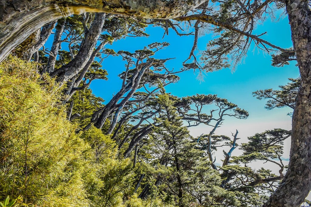
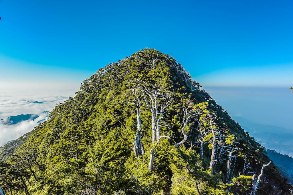
Shuanggui Lake Major Wildlife Habitat (雙鬼湖野生動物重要棲息環境) is located in the southernmost part of the Central Mountain Range (中央山脈) in eastern Taiwan. It is a mountainous area of untouched natural forests that serves as an important habitat for animals. Beidawushan (北大武山) is the highest and most prominent peak out of the 55 named mountains in the reserve with an elevation of 3,092 metres (10,144 ft).
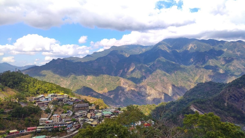
Shuanggui Lake Major Wildlife Habitat is located in parts of three counties: Maolin District (茂林區) in Kaohsiung City (高雄市), Wutai (霧台鄉) and Taiwu (泰武鄉) townships in Pingtung County (屏東市), and Yanping Township (延平鄉) of Taitung County (臺東市). It covers an area of 47,723 ha (117,926 acres).
Sandwiched between Guanshan Major Wildlife Habitat (關山野生動物重要棲息環境) and Dawu Mountain Nature Reserve (大武山自然保留區), Shuanggui Lake Major Wildlife Habitat is surrounded by pristine nature. In fact, the wildlife habitat contains the densest concentration of Taiwan fir on the island with over 10,000 individual trees in its borders.
Beidawushan is the only mountain in the wildlife habitat that’s part of Taiwan’s top 100 peaks. In addition, it is the only hill in the reserve to reach over 3,000 metres (9,842 ft) in elevation.
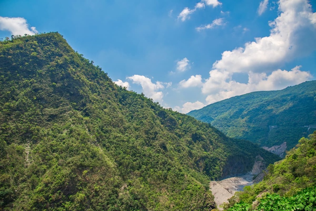
As the Shuanggui Lake Major Wildlife Habitat sits at the southern end of the Central Mountain Range, the topography of the habitat is hilly, but not exceptionally rugged.
Wutou Shan (霧頭山), Songshan (松山), Shisuitou Shan (石穗頭山), and Damumu Shan (大母母山) are other prominent mountains in the wildlife habitat. The elevation ranges between 620 metres (2,034 ft) to Beidawushan’s summit at 3,092 metres (10,144 ft).
In addition to the hilly terrain, a number of alpine lakes, including Daguihu Lake (大鬼湖), Honggui Lake (紅鬼湖), Xiaogui Lake (小鬼湖), Wanshanshen Lake (萬山神池), and the Lan Lake (藍湖) are present in the wildlife habitat.
The wildlife habitat also has an average annual rainfall total of 4,000 mm (157 in). May to September are the rainy months in the region as tumultuous typhoons in the summer months bring torrential rain to Taiwan.
Dulan Forest (都蘭林場) is located to the east of Shuanggui Lake Major Wildlife Habitat, while the butterfly sanctuary of Maolin National Scenic Area (茂林國家風景區) sits to the west. Meanwhile, to the south is Dawu Mountain Nature Reserve and the Hengchun Peninsula, which features Taiwan’s only subtropical Kenting National Park (墾丁國家公園).
Furthermore, Yushan National Park (玉山國家公園), which features Taiwan’s tallest peak, Yushan (玉山), sits above Guanshan Major Wildlife Reserve, which is located to the north of Shuanggui Lake Major Wildlife Reserve.
The hills of Shuanggui Lake Major Wildlife Habitat form the southern extension of the Central Mountain Range, Taiwan’s longest chain of peaks. The mountains form a long row that extends from southern Pingtung County all the way to New Taipei City (新北市).
The hills at either end of the range are gentler and flatter than those in central Taiwan. Beidawushan is the southernmost mountain of Taiwan’s 100 highest mountains, which are also known as Baiyue.
Collapsing fault lines are present around Dagui Lake that date back to the Tertiary period. Meanwhile, crystalline schist forms much of the bedrock in the region.
In the southern part of Shuanggui Lake Major Wildlife Habitat, the rock strata consist of Tananao schist from the Palaeozoic to the Mesozoic eras. In the eastern part of the reserve, the hills consist primarily of shales from the Miocene epoch.
There are four distinct ecoregions in the Shuanggui Lake Major Wildlife Habitat.
The plant life of Lauraceae-Machilus communities dominates in the lower elevations of the reserve from 500 to 800 metres (1,640 to 2,625 ft). Plant species such as the Formosan ash and sweetgum dominate the forest at these lower elevations.
Between 800 to 1,500 metres (2,625 to 4,921 ft), camphor trees and Japanese zelkova are the primary species in the Lauraceae-Serrata woods.
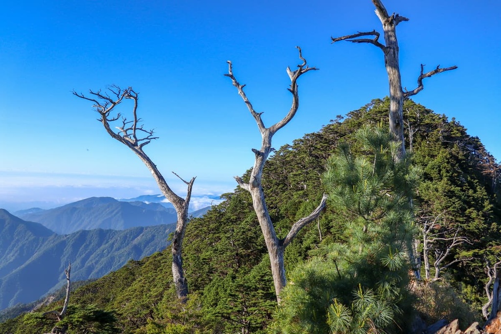
As the elevation increases to about 1,500 to 2,500 metres (4,921 to 8,202 ft) the foliage becomes a coniferous hardwood forest of Taiwan red cypress and Taiwan hemlock. Finally, from 2,500 metres (8,202 ft) and above, there are the coniferous woodlands of Taiwan cedar, Taiwan fir, and Taiwan pine.
These ecosystems of mountain forests and lakes provide a nurturing habitat for wild animals.

In terms of wildlife, the Shuanggui Lake Major Wildlife Habitat area is home to 26 mammals, such as the Formosan clouded leopard and Taiwan sambar deer. Additionally, wildlife officials in the region have recorded 86 species of birds in the reserve, including 10 species of birds of prey.
Beidawushan is steeped in the traditional folklore of the Paiwan, the Indigenous peoples of what is now Shuanggui Lake Major Wildlife Habitat. The peak is featured in many traditional songs and poetry in Paiwan culture.
The Paiwan people use the name Mount Kavulungan to refer to the sacred mountain of Beidawushan. They hold reverence to the tall peak as they believe the mountain fosters the souls of their ancestors.
According to a Paiwan legend, goddesses who live on Beidawushan bestowed upon their people specialised farming skills for subsistence and survival. To prove their gratitude, the goddesses asked the Paiwan to invite them sporadically to their village. Thus, the Paiwan celebrate the festival of Maleveq every five years to thank the goddesses for their blessings.
While the Paiwan respect Beidawushan for spiritual reasons, it is also a place that honors the fallen fighters of the Takasago Volunteer Army. During the Second World War, when the Japanese Occupation Era was underway in Taiwan, Japanese military officials forced many Indigenous people in Taiwan to help Japan battle against its enemies.
During this time, many Indigenous people in Taiwan joined together to form the Takasago Volunteer Army, fighting alongside the Japanese in Southeast Asia. Many of the Indigenous people who fought for the army lost their lives during the war. Thus, for this reason, a monument was erected on the sacred Beidawushan to pay respects for these fallen soldiers.
There are a number of excellent hiking areas in Shuanggui Lake Major Wildlife Habitat. Some of the most popular trails include:
The journey ascending the sacred mountain of Beidawushan involves a two-day trek and 9 km (5.5 mi) of hiking. Due to its steep incline, Beidawushan is a challenging climb as hikers need to climb near-vertical rock walls and tread carefully over rocky ridges to reach the summit.
The trek to Beidawushan is adorned with historical monuments. Hikers first encounter the Takasago Volunteer Army monument honouring the lives of Paiwan fighters who died during the Second World War.
A short walk ahead, visitors will come across the Dawu Temple and Otake Shrine, which was erected by the Japanese. A strikingly tall torii gate stands before Dawu Temple and Otake Shrine. The Japanese constructed Dawu Temple to honour the lives of deceased Japanese soldiers who fought in Pearl Harbour.
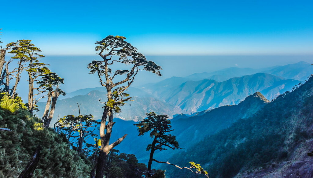
Apart from these commemorative elements, Beidawushan brims with a variety of plant species. In the temperate forest belt, the largest hemlock forest in Taiwan flourishes on the slopes of Beidawushan.
Additionally, along the path an ancient red cypress tree dating back 1,000 years towers above the verdant thriving flora of the hike. It measures a height of 25 metres (82 ft) and has a circumference of 11.7 metres (38 ft).
After an exhausting climb to the summit, hikers can appreciate the alpine shrubbery sprouting above the weightless dollops of creamy clouds. To the north, hikers can note Taiwan’s tallest peak, Yushan, in the distance.
Although dense shrubbery partially obscures the summit, hikers can distinguish Nandawushan (南大武山) to the south. In addition to this, hikers can admire the Hengchun Peninsula unfolding before them, where the Bashi Channel, Taiwan Strait, and the Pacific Ocean meet and merge.
The Three Lakes Hiking Trail is an arduous nine-day trek that covers 75 km (46 mi) and leads to Xiaogui Lake, Honggui Lake, and Dagui Lake. Hikers can climb a total of seven mountains along this extensive trail.
While the highlight of this route is the three alpine lakes, the region’s display of raw and untouched nature is also worth experiencing. An abundance of wildflowers radiates along the trail with floral hues, such as Taiwan iris, chrysanthemum, violas, horse blue, and wild peony.
Starting from Zhiben Forest Road, hikers begin the trek, reaching the first lake, Xiaogui Lake, only on the third day. A thick cedar forest surrounds Xiaogui Lake, where Formosan clouded leopards are known to roam.
The following day, hikers climb Dapu Shan (大浦山), which leads to Honggui Lake. Clusters of red juniper trees frame the banks of the still lake, mirroring the leafy green world in its waters. Woodlands of giant red junipers with a circumference of 15 metres (49 ft) dominate the virgin forests of Dapu Shan.
Two days later, after reaching the summits of Baican Shan (拜燦山) and Yaobai Shan (遙拜山), hikers proceed upon Dagui Lake, the most scenic and most prominent lake in the region.
As the lake sits at an elevation of 2,200 metres (7,217 ft) on the northeast slope of Yaobai Shan, the humidity in the region is constantly high; therefore, a layer of fog suspends above the turbid waters of Dagui Lake.
The three remaining days of the trek take hikers through Huanxi Shan (歡喜山), Lunyuan Shan (倫原山), and Damumu Shan before arriving at the 7 km (4.3 mi) mark of Zhongxing Forest Road.
Translated into English as ‘foggy mountain’, Wutuo Shan is notorious for its constant cloud cover and murky mist. The journey to the summit of Wutou Shan is a 9.5 km (6 mi) adventure that takes approximately three days.
Along the way, hikers can see the many collapsed rock walls and fault lines that dominate the region. The track is rocky and unsteady in places; thus, hikers should be cautious when trekking through the region.
Due to the stormy climate and the shaded woodland paths in the region, the trail is exceptionally damp and muddy. The course also bursts with ecological splendour and it features thick alpine forests of Yushan rhododendron, cypress, and hemlock.
From the summit of Wutou Shan, hikers can see Beidawushan to the south. At the same time, hikers can also observe the surrounding peaks of Songshan, Chapuyan Shan (茶埔巌山), and Xiadie’er Shan (霞迭爾山).
As Wutou Shan is an extension of Beidawushan, the trail also connects the two peaks. Thus, hikers can also summit Beidawushan during this adventure.
Situated in the far west region of Shuanggui Lake Major Wildlife Habitat is the emerald mountain woodlands of Damumu Shan.
A 9 km (5.5 mi) path leads to the summit, and the journey is best divided into a two-day trek due to the complexity of the craggy and collapsed terrain. However, if hikers wish to climb the peak in one day, it is best to start early as cloud cover inhibits visibility when descending the mountain in the evening.
Starting from the 7 km (4.3 mi) mark on Zhongxing Forest Road, hikers begin by ascending Damumu Shan. However, it is best to avoid this trail after periods of heavy rain due to the frequency of mudslides in the region.
On the way up, an abundance of wildflowers embellishes the trail with striking colours of deep violet, soft lilac. There are also intense pinks along the way from the blossoming Taiwan cobra lily, wild peony, and mountain cherry flowers.
A dense woodland of shrubbery camphor trees shades the trail from radiant sunlight as hikers pass through a forest that’s drenched in dampness and covered in a furry coat of moss.
As a thicket of camphor trees obscures the summit of Damumu Shan, hikers cannot get any views from the peak. However, in the clearings along the path, hikers can admire the peaks of Beidawushan, Wutou Shan, Jingbu Shan (井步山), and Dewen Shan (德文山).
Situated in Wutai Township of Pingtung County, Shenshan Waterfall Trail is the star attraction of this area. While the path to Shenshan Waterfall (神山瀑布) is only 1 km (0.6 mi) in length, it ventures through an ecological wonderland of the warm-temperate vibrant ferns that softly spread their delicate feathered fingers across the humid forest floor.
With an average temperature of 63°F (17°C) and an elevation of 1,000 metres (3,281 ft), the trail of Shenshan Waterfall is frequently immersed in refreshing mist. A suspension bridge stretches across the Bei Ailiao River, where hikers can observe the stream life of silvery shades of scorpionfish through the cold clear waters.
The winding mountain trail further leads through the hardwood Jiuxiong trees (Lagerstroemia subcostata) and giant thorny bamboo (Bambusa bambos). Hikers can then follow the path down toward an arched wooden bridge before the unveiling of Shenshan Waterfall.
The view of Shenshan Waterfall is exquisite from the trail. Here, a white foamy water flows against the dark grey slate walls brushed with flourishing green plants. An aquamarine pool collects at the base of the waterfall, reflecting Taiwan's azure blue sunny skies.
Tao Lin Hot Spring is set in the Luye River Valley between Taiermashan (太兒麻山) and Fengshan (楓山).
Hikers can trek a 15 km (9.3 mi) route to the swirling rust-coloured canyons of Tao Lin Hot Springs (桃林溫泉) along this exciting trail. The journey is challenging as hikers must first climb the trail to Fengshan, which features sharp, narrow ridgelines that lead to a steep gorge.
As hikers trace the meandering edge of a canyon, stalactites drip from sunken calcium carbonate caves. Hikers then proceed past dried up waterfalls, progressing further into a jungle of Taiwan cycads.
Following the descent into the valley, hikers then tread alongside the rocky banks of the Luye River. At the confluence of the Luye River and Malalaou Creek, there is a striking marble gorge that features cliffs streaked with burnt orange erosion and swirls of black schist intertwined with lustrous pale marble.
The thermal pool of Tao Lin Hot Springs is further along the descent down the trail. Here, minerals of neutral sodium bicarbonate are dissolved in these magnificent waters that are approximately 180°F (82°C).
The highlight of Tao Lin Hot Springs is the sparkling crystalline rock walls that shimmer in the sunlight, contrasted against the burnt orange and creamy white striped marble cliffs that rise overhead.
As the Shuanggui Lake Major Wildlife Habitat spans three counties, the cities of Taitung, Kaohsiung, and Pingtung are some of the best places to stay nearby. These three cities compel tourists to visit for different reasons, as they all possess their own unique identities.
Taitung City is located on the intrepid east coast of Taiwan, which is the most remote region of this island.
While the west coast is well connected with a network of highways and railroads, the east coast has only a single train track connecting the east to northern and southern Taiwan. The Central Mountain Range limits travel to the east coast; however, this is more a blessing than a curse. For tourists seeking the utmost relaxation while being surrounded by nature, Taitung is the place to be.

For the best views over Taitung City, visitors should climb the shallow coastal hill of Liyu Shan (鯉魚山). From 76 metres (249 ft) above, visitors can admire the entire coastal area of Taitung City, from the palm trees lining the streets that lead towards the expansive Pacific Ocean. On a clear day, visitors can even locate Green Island (綠島) and Orchid Island (蘭嶼) in the east.
Adventurous travelers can access the popular Green Island and Orchid Island by ferry from Taitung City. Volcanic activity created both islands, so they're a true geologist’s delight. Snorkelling, diving, swimming, and fishing are the top activities to enjoy on both islands. Additionally, visitors to the island can also admire the uplifted coral reefs and observe the crab life in the region.
The Luye Highlands in the nearby Beinan Township (卑南鄉) of Taitung are an enchanting place to appreciate the beauty of nature. Swatches of patchwork fields decorate the gently rolling hills, displaying different shades of green interlaced against each other.
The Luye Highlands is also the location of the highly coveted annual Taitung International Balloon Festival. During the festival, the sky is infiltrated with quirky and clute floating balloons that glide across the landscape. People from all over the globe gather to see and fly these amazing hot air balloons.
Taitung is also synonymous with tranquillity, and no place defines this better than a hot spring. Numerous hot springs are scattered in and around Taitung City, with Zhiben Hot Springs being one of the top-rated establishments, though there are plenty of more budget-friendly places to stay, too.
Taiwan’s lively second-largest city, Kaohsiung, is a magnet for city slickers wishing to discover the bustling port city in the southern part of the island. Visitors to the city are spoiled with a metropolis of impressive skyscrapers, countless temples, quirky landmarks, and an endless variety of attractions to visit.

A must-see spot in Kaohsiung, Lotus Lake features an artificial pool with three animated and charismatic pavilions along the lake’s edge. Bridges link the pavilions to land, with paths connecting them.
The first and most popular pavilion is the Tiger and Dragon Pagoda. Here, seven-story twin pagodas stand together, with lively characters of a fierce tiger and a raging dragon as guardians to the honey golden towers. Visitors enter the structure through the dragon’s mouth, from where they will find a staircase leading to the pagoda. Upon exiting, visitors walk through the tiger’s mouth, completing the circuit.
Kaohsiung’s equivalent to Taipei 101, 85 Sky Tower, is imposing in height and striking in design. Resembling the ‘gao’ character in Chinese, 85 Sky Tower rises above the other skyscrapers and landmarks in the region. As its name suggests, the dynamic structure is 85 stories high and measures 347.5 metres (1,140 ft).
For the most impressive views of Kaohsiung’s city centre, visitors should climb the trails of Shoushan National Nature Park (壽山國家自然公園). Set against the shores of the Taiwan Strait, Shoushan National Nature Park affords views of both modern urbanised structures and the endless sea.
In addition to views, the coastal hill is bathed in a tropical landscape of banyan trees and a wide variety of ferns. Visitors can also marvel at the 40-metre (131 ft) ravine of Taiguo Valley, where fine fibres of Jinping vine aerial roots descend like long earthen hair strands.
Taiwan’s second-largest city does not disappoint with its lively night markets. Established in the 1950s, Liuhe Night Market now has a community of 138 vendors who sell fresh seafood, delicious samples of local specialities, and other goods. Smooth and creamy papaya milk and flavoursome salted shrimp should be on everyone’s sampling list.
Taiwan’s southernmost city, Pingtung City, has more of a small-town atmosphere. Visitors to the city instantly feel the warmth of its people while soaking up the wholesome rays of the southern Taiwanese sun.
For visitors interested in learning about the customs and lifestyle of Pingtung’s Hakka people, the Liudiu Hakka Cultural Park (六堆客家文化園區) is a great place to check out. It offers exhibitions and live song and dance performances. The Hakka are descendants of the Han Chinese who migrated to Taiwan at the transition of the Ming and Qing dynasty.

In addition to learning about Hakka culture, in the Sandimen Village of Pingtung County, there is the Taiwan Indigenous Cultural Park (台灣原住民文化園區), which focuses on the different native tribes of Taiwan. This park is an outdoor museum that features exhibits about traditional home life and architectural designs of nine Indigenous tribes of Taiwan.
Additionally, the coral reef paradise of Xiaoliuqiu (小琉球) is located off the west coast of Pingtung. Like Green Island and Orchid Island, visitors to the area can enjoy swimming, diving, snorkelling, and fishing in the warm waters of the Taiwan Strait. Green turtles are native to the region, too, and those diving underwater can easily spot these creatures going about their day.
One of the highlights of Pingtung City is its proximity to the subtropical garden of Kenting National Park. Here, endless white sand beaches stretch across the sparkling blue shore, while a botanical garden of banyan trees adorns the forest. Visitors can marvel at the cosy caves in the park, which feature stalactites that hang down from above.
From the major cities of Taipei, Taoyuan, Hsinchu, Taichung, Chiayi, and Tainan, take the Taiwan High-Speed Rail to Kaohsiung.
Visitors can rent a car or scooter from Kaohsiung and drive to Shuanggui Lake Major Wildlife Habitat. Or, they can board a local express train (TRA) to nearby Pingtung City, which is located closer to the wildlife habitat.
It is a 29 km (18 mi) drive from Pingtung City to the borders of Shuanggui Lake Major Wildlife Habitat. Meanwhile, Kaohsiung is just 60 km (37 mi) away.


The highest peak in Shuanggui Lake Major Wildlife Habitat is Beidawu Shan, at 3,092 m.
Notable peaks in Shuanggui Lake Major Wildlife Habitat include Beidawu Shan, Chuyunshan, Santafeng, Mt. Wutou and Chuyun Shan Nanfeng.


