Scan the QR code and open PeakVisor on your phone
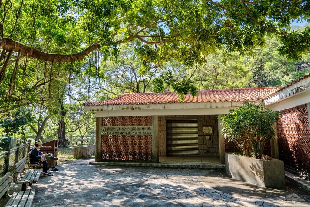
Shing Mun Country Park is an idyllic getaway located in the Hong Kong Special Administrative Region of China. It has 7 named mountains including the southeastern slopes of Tai Mo Shan (957 m/ 3,140 ft), the highest peak in the city.
Shing Mun Country Park is nestled in central New Territories of Hong Kong. It is located in the districts of Tsuen Wan and Kwai Chung on the southwestern side and Sha Tin and Tai Po on its eastern side. The park is connected to Kam Shan Country Park to the south, and it is flanked by Tai Mo Shan Country Park to the north and west.
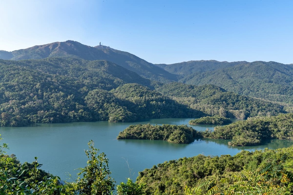
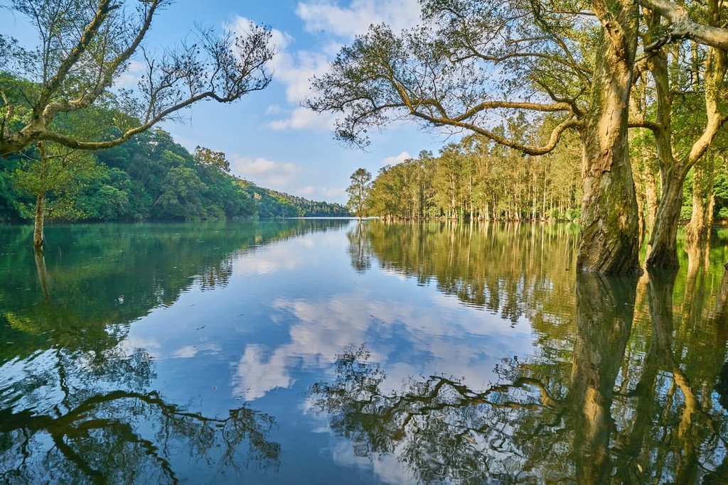
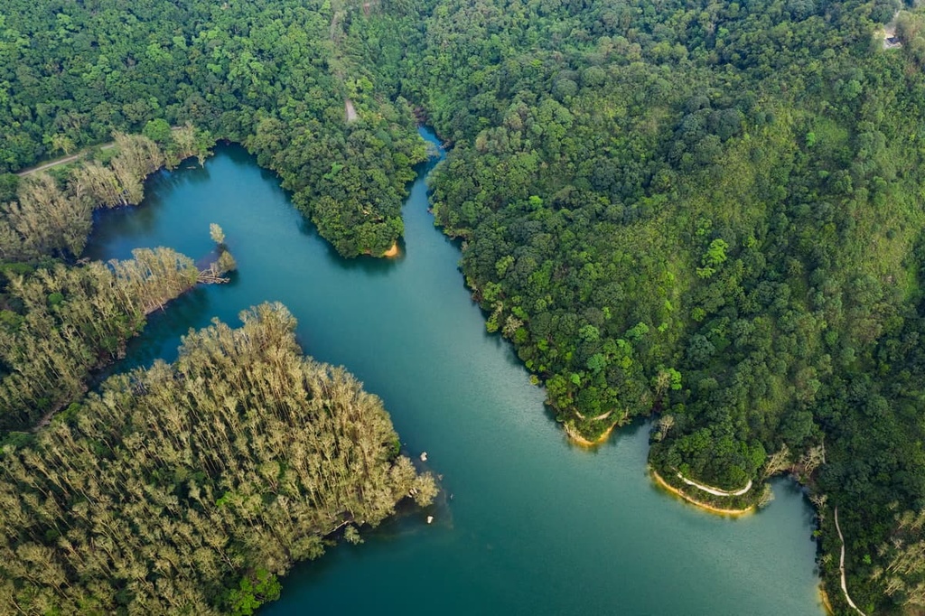
Covering an area of 1,400 hectares (3,460 acres), the park is a valley with Shing Mun Reservoir at the bottom. The reservoir is constantly fed by Tai Shing Stream—the biggest one in Hong Kong—and Tso Shing Stream among other tributaries.
The main dam of the reservoir, standing at 84 m (276 ft) tall at the southeastern edge, used to be the tallest dam in the British Empire when it was completed in the 1930s. There are two auxiliary dams on the western side of the reservoir, one of which is called Pineapple Dam. It was named after the fruit that once grew in abundance in the area.
The area around Shing Mun Country Park consists of granitic and other igneous rocks formed about 165 million years ago during the Jurassic. As granitic rocks are more susceptible to weathering than the other igneous rocks in the region, they form the lower grounds of the valley while the other more resistant igneous rocks make up the highest parts.
The northern end of the park contains lead deposits, which were mined as early as a few centuries ago, and the area is known as Lead Mine Pass. Although some abandoned mine workings can still be seen, information about the mining is scarce since the mining ended more than a century ago.
On the eastern border of the park, the slopes of Needle Hill have a generous reserve of tungsten (also known as wolfram), a rare metal as hard as diamond and as dense as gold. This substance also has an extreme thermal capacity with the highest melting point (3,410 °C/ 6,170 °F) of all known metals.
The tungsten was formed during volcanic activities when intruding magma left behind hydrothermal fluids containing volatiles and metal elements. Environmental changes such as the lowering of temperatures or pressure led to the release and concentration of certain elements, resulting in the formation of tungsten-bearing quartz veins.
Widely used in the production of high-speed ammunition and electronics, tungsten used to be mined at Needle Hill from 1938 to 1967, culminating in the early 1950s during the Korean War. With a workforce of over 2,000 people, Needle Hill was one of the biggest mining operations in Hong Kong.
Most of the vegetation cover in the park is secondary forest, as much of the original vegetation was devastated during the Second World War when the Japanese cleared it for fuel. The fauna has since made a remarkable recovery thanks to extensive replanting efforts.
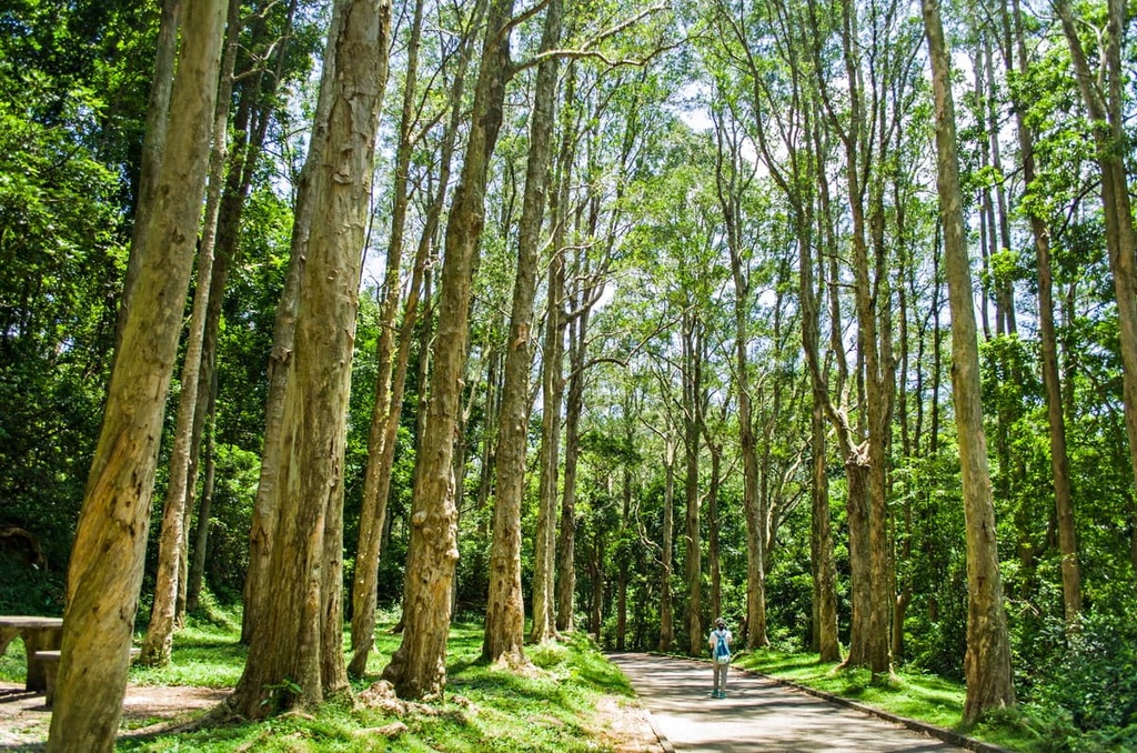
The paper-bark tree (Melaleuca quinquenervia) is one of the more widely grown species planted after the war. It produces some of the most popular sights in the park, like a paper-bark grove partly submerged in the reservoir and a corridor formed by two rows of imposing paper-bark trees.
One patch of forest that survived the war is the 6-hectare (15-acre) Shing Mun feng shui forest. This type of forest is unique to southern China, where people used to build villages in front of native woodlands that served to shelter houses from strong winds, to protect slopes from erosion, and to reputedly block evil spirits.
The villagers grew fruit trees and other plants with economic/medicinal value on the edge of these forests, adding to the biodiversity in the “enhanced” habitats. The Shing Mun feng shui forest is one of the most representative of its kind in Hong Kong because of its exceptional integrity and species richness.
On the northern side of the park, the 4-hectare (10-acre) Shing Mun Arboretum preserves some 300 endemic species, including rare and local protected plants, a climbing plant collection and a bamboo garden. Planting has been going on since the early 1970s on abandoned terraced fields.
The park boasts more than 20 kinds of food plants for over 120 species of butterflies and their caterpillars. The common bluebottle, the Chinese peacock and the Paris peacock are some of the most flamboyant butterflies there.
The area is also a haven for birds with over 70 recorded species. Commonly sighted birds include the black kite, little egret, fork-tailed sunbird, scarlet-backed flowerpecker, and red-whiskered bulbul.
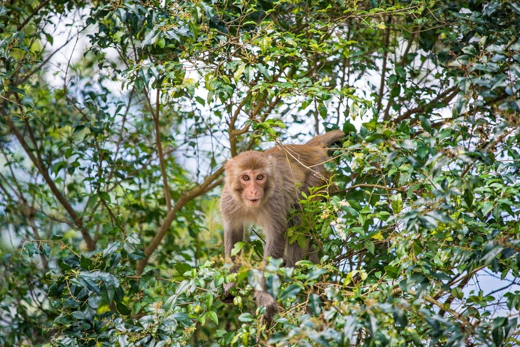
Visitors to the park will probably see quite a few macaques, which are actually introduced animals. The common muntjac, Chinese pangolin, and Styan squirrel are some other mammals found in the park.
The reservoir and streams provide ideal habitat for a variety of aquatic animals like fish, shrimps and tortoises, but invasive species released by people is a problem. Fishing is allowed in the reservoir in the non-spawning season for anglers with fishing licenses.
In the mid-seventeenth century, just after the Ming Dynasty was overthrown by ethnic Manchus, Ming loyalist Li Wanrong (李萬榮) brought his troops to Hong Kong to seek refuge. They became bandits and built a fortress in a river valley, which became known as “Shing Mun”(城門), which literally means fortified gate in Chinese.
The fortress was demolished after the Manchus subjugated Li’s gang in 1656. Soon after that, ethnic Hakka people began to settle in the area, making a living by raising livestock and growing crops, mainly rice, pineapple and tea.
There were eight villages in the area, where farmers carried on their rural life until the British colonial government made plans to build a reservoir in 1923. More than 800 villagers within the catchment area were relocated in the late 1920s. The remains of some farmlands can still be seen.
The initial stage of the reservoir construction was fraught with malaria, with more than 10 percent of the workers infected. The problem improved with land drains and the use of mosquito nets at the suggestion of the local university’s medical department.
Shing Mun Reservoir was completed in 1935, coinciding with the Silver Jubilee of King George V. Hence the reservoir was also called the Jubilee Reservoir. Its main dam, bellmouth overflow and some other components have been listed as Grade I historic buildings.
Just before the Second World War, the colonial authorities deployed a key defense line known as Gin Drinkers Line in the late 1930s in anticipation of a Japanese invasion. The area next to the reservoir was the focal point of this 18-km (11-mi) line.
The defense line was made up of pillboxes, observation posts, trenches and bunkers connected by underground tunnels named after streets of London. It collapsed after a brief battle with the Japanese in December 1941, but many features remain to this day.
The park was designated in 1977, along with Lion Rock Country Park and Kam Shan Country Park on the same day. Together they became the first three country parks in Hong Kong.
The park is a popular destination not just for hiking but also having picnics and flying kites. Here are the best hikes for visitors to check out.
This 8.5-km (5.3-mi) trail is a relaxing walk with picture-perfect views. It passes by the main dam, which has majestic views of the iconic peak of Lion Rock and the city’s highest peak—Tai Mo Shan. All the while, the tranquil emerald waters of the reservoir stay in the foreground.
On the eastern shore, the trail winds past a striking paper-bark corridor and a paper-bark grove which also serves as a much sought-after background for wedding photos. Also on this side is the Pineapple Dam Nature Trail that showcases the diverse local flora and fauna.
A short detour from the nature trail will take you to the Butterfly Paradise. Not far away, the unspoilt streams of Tai Shing and Tso Shing, as well as the feng shui forest flank the north shore.
Getting its name from its sharp profile, Needle Hill (532 m/1,745 ft) offers sweeping vistas of northwestern New Territories, Shing Mun Reservoir, and Lead Mine Pass. Climbing to the top means slogging up steep flights of steps but it is well worth the effort.
Grassy Hill (647 m/ 2,123 ft) forms the water divide between Shing Mun Valley and Sha Tin Valley beyond the eastern border of the park. The panoramic views encompass Sha Tin district dominated by the massive Ma On Shan range, Tai Po district with its sprawling Pat Sin Leng range and the pristine countryside of the Sai Kung peninsula.
Both peaks lie on Section 7 of the MacLehose Trail. Coming off the two hills from the south, hikers will reach the crossroads of Lead Mine Pass, where they can continue on to Tai Mo Shan Country Park or Tai Po district, or walk down to Shing Mun Reservoir.
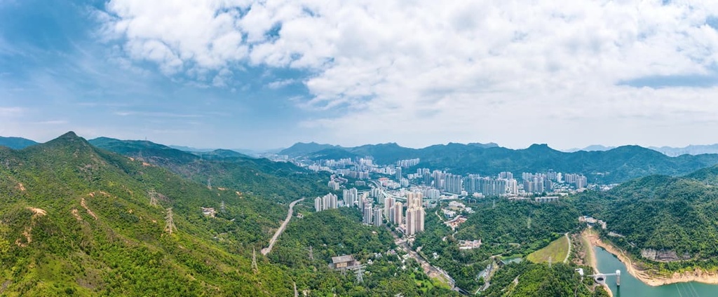
The main gateway neighborhood is Tsuen Wan, which was once an industrial district but has recently transformed into a multi-faceted community with gleaming shopping malls, sleek commercial buildings such as the 80-storey Nina Tower 1, as well as residential and recreational complexes.
Attractions in Tsuen Wan include the Mills (revitalized from textile factories), Sam Tung Uk Museum and peaceful temples on idyllic Fu Yung Shan. The district is also a gateway to Tai Mo Shan Country Park.