Scan the QR code and open PeakVisor on your phone
In a small hilly pocket of land in Yushan National Park (玉山國家公園) lies Sancha Mountain and Xiangyang Mountain Special Scenic Area (三叉山、向陽山特別景觀區). Rich in the ecology of high mountain forests, this area in central Taiwan holds 7 named mountains. Xianyang Shan (向陽山) is the tallest and most prominent peak at 3,603 meters (11,821 ft).
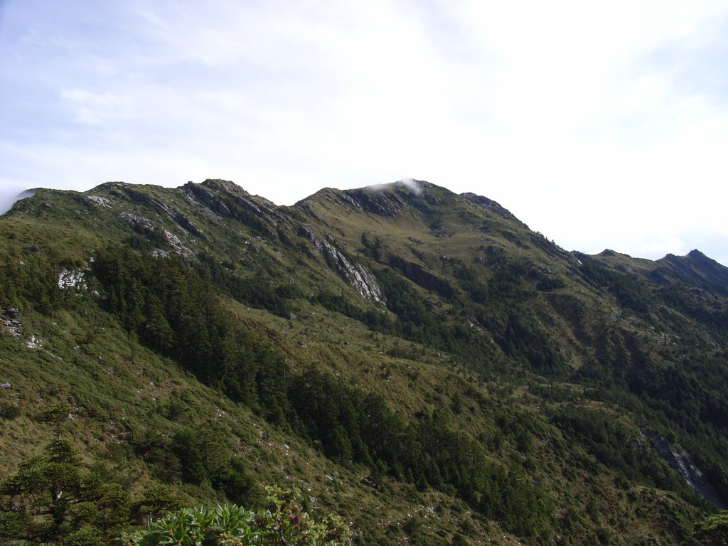
Sancha Mountain and Xiangyang Mountain Special Scenic Area lie in the Haiduan Township (海端鄉) of Taitung County (臺東縣). Situated in the southern region of Yushan National Park, Sancha Shan (三叉山) and its surrounding hills comprise the inner region of the Central Mountain Range (中央山脈), Taiwan’s longest massif.
As the Central Mountain Range intensifies towards central Taiwan, Sancha Shan’s region is very hilly and rugged. Three of the seven summits in Sancha Mountain and Xiangyang Mountain Special Scenic Area fall under Taiwan’s tallest 100 peaks, also called Baiyue. These are Xiangyang Shan, Sancha Shan, and Guanshanlingshan (關山嶺山).
The remaining four mountains extend over 3,000 meters (9,843 ft) in elevation. These are Xitou Shan (溪頭山), Xiangyang Shan Beifeng (向陽山北峰), Mobaolai Shan (魔保來山), and 3269feng (3269峰).
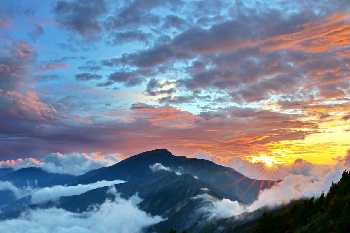
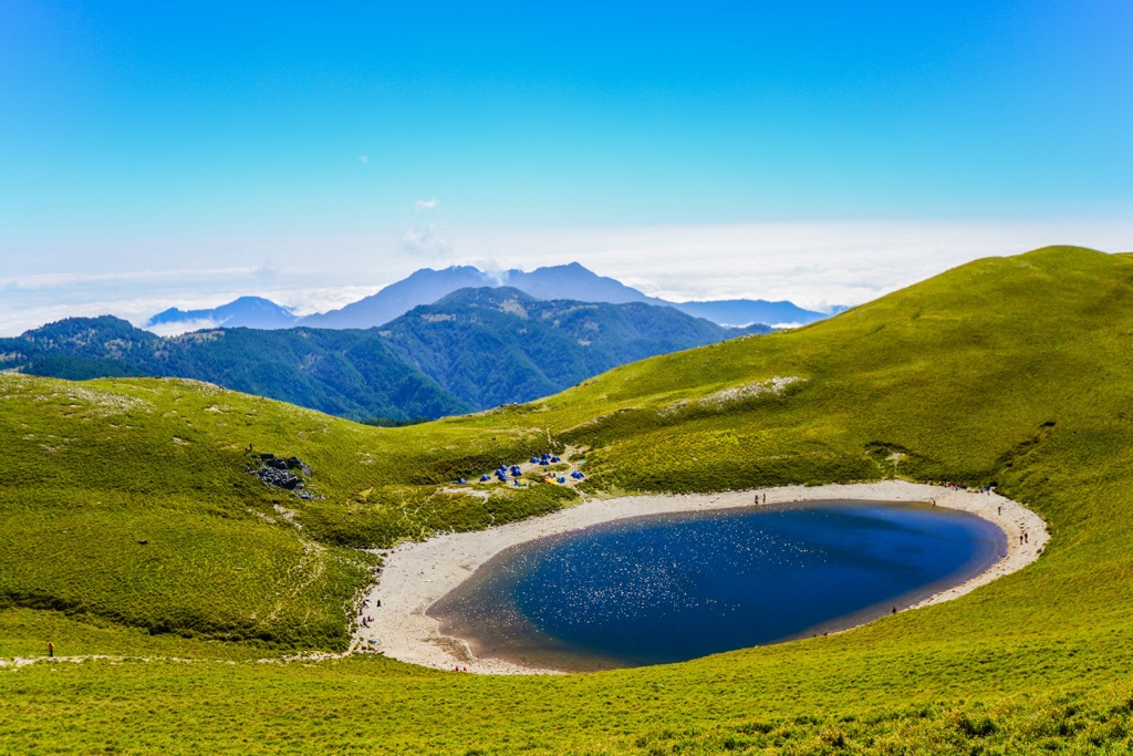
Situated on Sancha Shan’s southeastern slope is Jiaming Lake (嘉明湖), Taiwan’s second-highest alpine lake at 3,310 meters (10,860 ft).
The high-elevation terrain receives a heavy yearly rainfall between 3,000 to 4,700 mm (118 to 185 in). Moreover, there is an average temperature of 46°F (8°C) at elevations over 3,000 meters (9,842 ft), which increases to 52°F (11°C) from 2,500 meters (8,202 ft).
While Sancha Mountain and Xiangyang Mountain Special Scenic Area lie in a remote part of Taiwan, many areas of significant interest are nearby. Xinkangshan Special Scenic Area (新康山特別景觀區), also part of Yushan National Park, spreads to the east with Guanshan Major Wildlife Habitat (關山野生動物重要棲息環境) to the south. Yushan (玉山), Taiwan’s tallest peak, is to the north, while the historic Zhongzhiguan Ancient Road (中之關步道) is to the west.
Sancha Shan and its surrounding hills comprise the 270 km (168 mi) long Central Mountain Range. Spanning from southern Pingtung County (屏東縣) to northern Yilan County’s (宜蘭縣) coast, Taiwan’s longest sierra holds 1,249 named mountains and 59 of Taiwan’s 100 tallest peaks.
The hills strata comprise a mix of slate, sandstone, and phyllite from the Eocene epoch.
As a result of the high-elevation of Sancha Mountain and Xiangyang Mountain Special Scenic Area, the park is primarily coniferous woodland with some broadleaf trees in the lower forest zones. You’ll find camphor, Tung, and banyan trees in the hardwood forests, which then mix with Taiwan white-pine and Taiwan cedar softwoods.
Higher up the mountain, you’ll find Taiwan fir, Yushan juniper, and arrow bamboo (Pseudosasa japonica), while flowering plants of Yushan rhododendron, Alishan gentian, and Taiwan lily grow near the mountain’s summit.
![]()
There is also a petrified white forest on Xiangyang Shan of Yushan juniper, Taiwan fir, and Taiwan spruce. The cold mountain climate froze these conifers, causing them to decompose and strip their color. Known as Baimulin, this deadwood forest is a popular attraction on Sancha Shan.
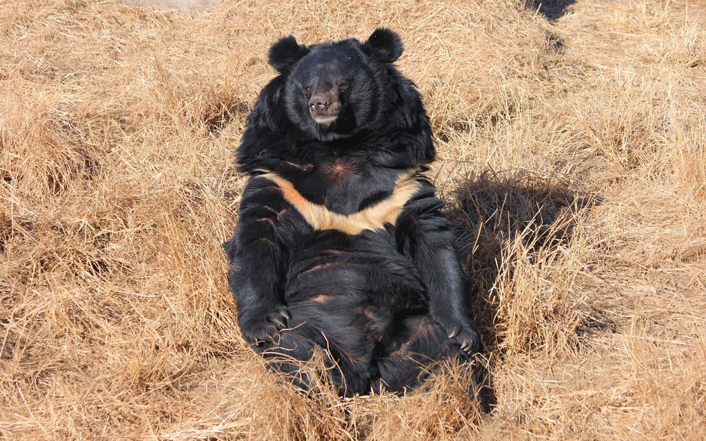
Due to its primitive flora, Sancha Mountain and Xiangyang Mountain Special Scenic Area is a significant wildlife habitat, home to the Taiwan black bear, Taiwan macaque, and Taiwan sambar deer. There are many species of squirrels, and the rare Alishan salamander inhabits the hilly creeks.
The Bunun tribe were the earliest inhabitants of Sancha Mountain and Xiangyang Mountain Special Scenic Area and still live in the region today. During the Japanese Occupation Era, Japanese officials forced the Bunun people to move from their mountain residences. The Japanese wanted to utilize the region’s rich resources, such as timber.
Further north is the Batongguan Yueling Road (八通關越嶺), where the Japanese forced the Bunun people to live under strict surveillance. You can still walk this road today to witness the abandoned police posts, artifacts, and evidence of past living in the rural region. The Walami Hiking Trail leads to this once-oppressed historic road.
On the Walami Hiking Trail, you can find a memorial to Kasipanan Incident’s victims. During the fourth year of Taisho (1915), the Bunun raided a Japanese police station, setting fire to the building and cutting the telephone lines as revenge for the Japanese confiscating their weapons. There were no survivors, and this revolt inspired other indigenous Taiwanese tribes to rebel against the Japanese.

The primary hiking trails and areas in and around Sancha Mountain and Xiangyang Moutain Special Scenic Area are:
Jiaming Lake Hiking Trail is a notoriously challenging route, incorporating steep inclines and rocky terrain. Forming the last part of the 89 km (55 mi) South Second Section Hiking Trail, you can tackle Jiaming Lake’s 13 km (8 mi) steep path if you prefer a shorter route.
You’ll begin climbing Xiangyang Shan to progress towards Sancha Shan. Take it slow and purposefully as you ascend the sloped path. You’ll encounter Xiangyang Shan’s petrified frosted forest, Baimulin. The ethereal woods of Yushan juniper contort their milky branches, resembling extraterrestrial life forms. Ashen Taiwan fir stands proudly, while Taiwan spruce displays a network of pale white needles.
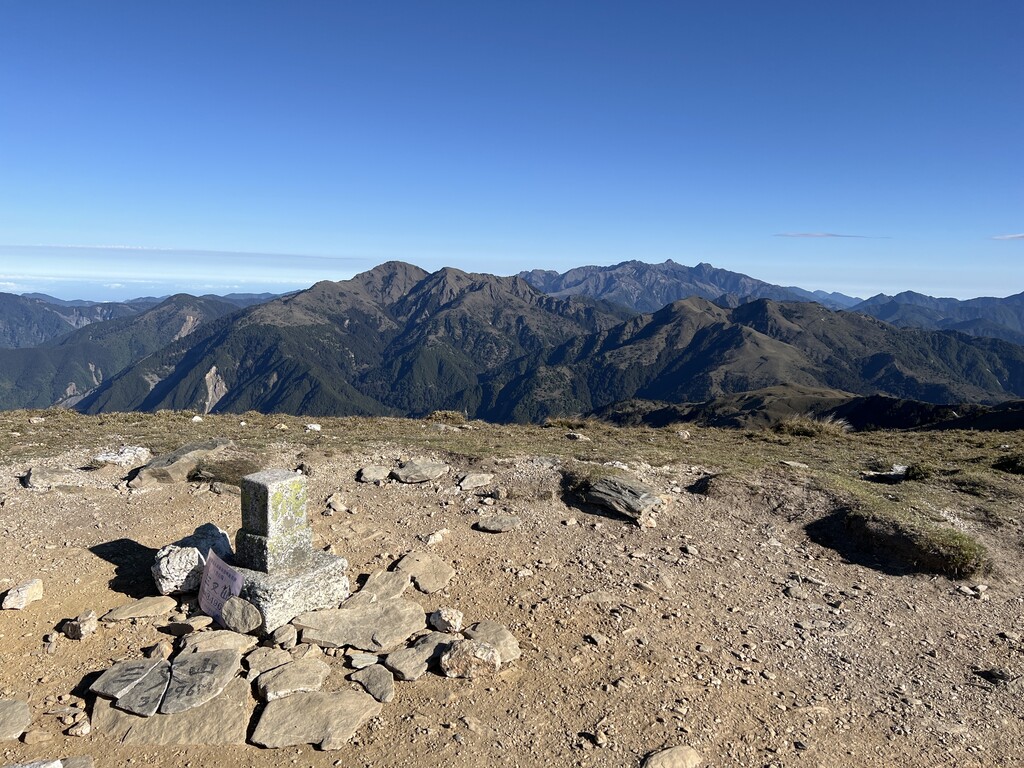
After spending the night on Xiangyang Shan, you’ll head to Sancha Shan along an alpine grassland. Here you will see a flowering path of Alishan gentian, Yushan rhododendron, and Yushan azaleas. When you reach Sancha Shan, the views are incredible, with clear prospects of Xiangyang Shan, Xinkang Shan (新康山), Xiuguluan Shan (秀姑巒山), and Yushan.
As you descend the mountain, you’ll reach Jiaming Lake on Sancha Shan’s southeast slope. Taiwan sambar deer usually roam around the alpine lakeside, while Jiaming Lake looks majestic as it radiates the sun’s glow on its still surface.
Xinkangshan Crosswalk Trails follows some of the Jiaming Lake Hiking Trail. Along this 27 km (17 mi) trek, you’ll summit five peaks in five days.
You’ll begin the route climbing Xiangyang Shan like on the Jiaming Lake Hiking Trail. So you’ll proceed past Baimulin, ascend Sancha Shan, and then pass Taiwan’s second-highest alpine pond, Jiaming Lake.
Next, you’ll head westwards to Lianli Shan (連理山), a craggy behemoth that taunts you into thinking you’re near the summit. As you scramble up the cliff, you’ll be met with an overgrown mountaintop that obscures any views.
However, Xinkang Shan’s panoramic summit is only a 1.7 km (1 mi) hike away, where you’ll see the fascinating Tiangong Fortress. The rocky turret rests on the cliff, looking like a majestic castle. You’ll also see the pointed pinnacles of some of Taiwan’s giant mountains.
Finally, you’ll start your descent, but you’ll summit the peak of Xinxian Shan (新仙山) along the way, where you can gaze at Xinkang Shan and the beautiful Tiangong Fortress from a different perspective.
South of Sancha Shan and Xiangyang Shan is the Southern Cross-Island Highway, a main road connecting Taiwan’s east and west coasts. The Southern Cross-Island is one of the only highways you can travel between the coasts, as Taiwan’s inland is mostly impenetrable due to the rugged terrain.
Out of the four mountains, only Guanshanlingshan falls within Sancha Mountain and Xiangyang Mountain Special Scenic Area. Kuhanuoxin Shan (庫哈諾辛山), Guanshan (關山), and Taguan Shan (大關山) are the remaining peaks.
The Southern Cross-Highway Hiking Trail comprises a series of trails you can trek individually or as one long multi-day journey. You’ll start with Kuhanuoxin Shan, the steepest of the four peaks. Past the 2,000-meter (6,562 ft) point, you’ll encounter a temperate forest of Taiwan hemlock and a Taiwan fir grove further along the elevation.
From Kuhanuoxin Shan’s summit, you’ll locate Yushan in the north and Guanshan standing close by. You’ll then head to the tallest peak of the trail, Guanshan, which also has a scarily thin ridgeline you need to scramble across.
From there, you’ll progress to Taguan Shan, which has fragrant woodlands of Taiwan cypress, followed by a dense growth of arrow bamboo. You’ll enjoy clear prospects on Taguan Shan’s summit, overlooking Guanshan Beifeng (關山北峰) and Yingzizui Shan (鷹仔嘴山).
Finally, you’ll move on to Guanshanlingshan, the last mountain on the trail with the least challenging climb. From the summit, you can reflect on your journey as you gaze onto Taguan Shan, Guanshan, and Kuhanuoxin Shan's giant forms.
Explore the temperate woodlands of Xiangyang Forest (向陽國家森林遊樂區), situated at 2,320 meters (7,611 ft) above sea level. A vibrant mixture of hardwood maple, coniferous Taiwan red cypress, and Taiwan two-leaf pine dominate the ecology.
You’ll enjoy leafy paths that look out onto the dramatic mountainscape of this high-elevation forest. The trails burst to life in spring and summer with gentle tones from flowering plants. While in autumn, wander through the burgundy foliage with accents of gold and amber in the maple forest.
You can locate some of Taiwan’s highest peaks from the thriving mountain grove. You’ll observe Yushan, Xiuguluan Shan, and Batongguan Shan (八通關山) in the north, while in the west, you’ll find Taguan Shan, Xitou Shan (溪頭山), and Guanshan’s craggy cliff.
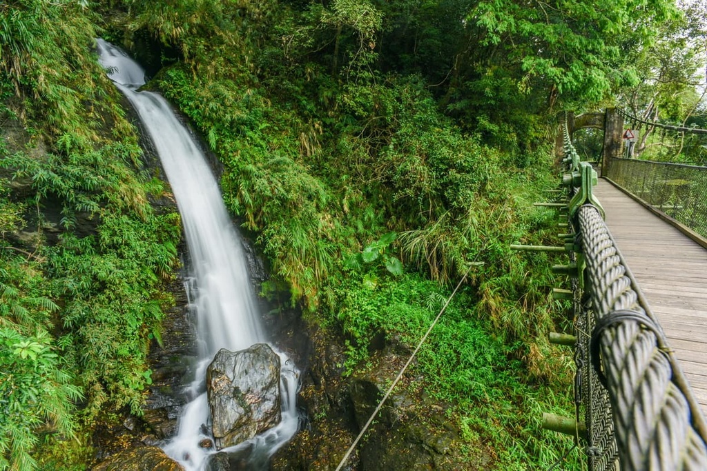
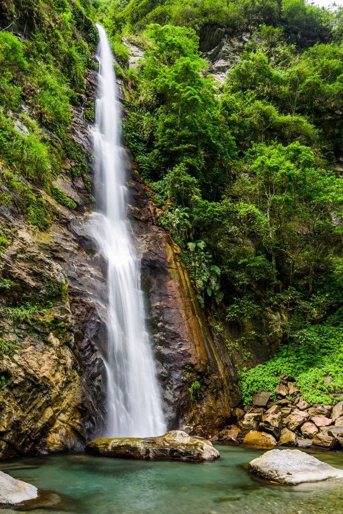
Wander the Walami Hiking Trail for a 14 km (8.6 mi) journey through lush-layered forests, a three-tier waterfall, and historical significance. Forming the eastern part of the Batongguan Yueling Road, many discarded police stations remain along the route.
You’ll happen onto the majestic Shanfeng Waterfall (山風瀑布) just 1.7 km (1 mi) into your hike. Stop and take a moment to gaze at this breathtaking masterpiece of foaming roaring rapids. The best views are from the 30-meter (98 ft) high suspension bridge, where the lowest tier spills its frothy falls into the turquoise pool.
As you progress, you’ll encounter an old Japanese police post near Jiashin. From here, you’ll also begin to see beautiful prospects of the nearby peaks of Yuli Shan (玉里山), Zhuoxi Shan (卓溪山), and Huangma Shan (黄麻山).
You’ll enter the Huangma Valley with camphor forests, rampant fern growth, and a velvety moss coating. Stand over the suspension with the gurgling Lakulaku River flowing underneath, and you’ll be at the halfway point. You need to turn around and retrace your route to the start point. Or you can continue on the 96 km (60 mi) Batongguan Yueling Road.
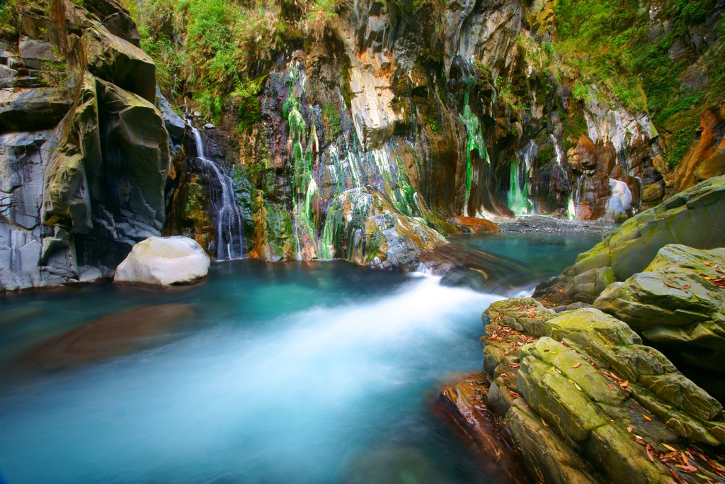
Take a trip to Lisong Hot Springs (栗松溫泉) to see one of Taiwan's most impressive caves and thermal streams. A weak alkaline carbonate waterfall of 30 meters (98 ft) height supplies mineral qualities to the thermal river's 149°F (65°C) water. As a result of the falling rapids, the rock walls have a milky green coat.
After trekking through rugged terrain for 3 km (1.8 mi) to reach the remote hot spring, a warm bath is a perfect way to relax. Take a dip in the teal stream, which bubbles with misty vapor. Due to the humidity, velvety algae growth will also occur on the rock walls.
Taitung City (臺東市) and Yuli Township (玉里鎮) are two places to stay near Sancha Mountain and Xiangyang Mountain Special Scenic Area.
Known for its infectious slow-living and pristine natural beauty, staying in Taitung City is a gift not many are fortunate to experience. One of Taiwan’s most remote cities, the journey to Taitung City is much lengthier than visiting Taiwan’s other major cities along its well-connected west coast. Once you’re there, the journey is well worth it for the blissfully beautiful scenery.
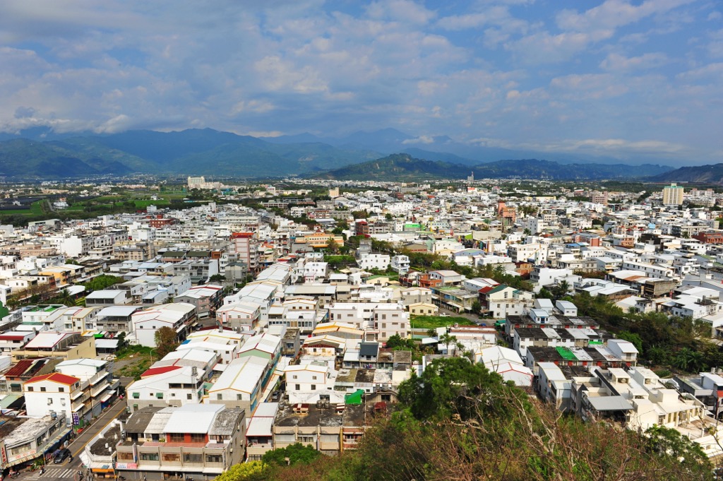
One of the first places you’ll want to visit to survey the scenic city of flourishing forests and the deep blue sea is Liyu Shan (鯉魚山). Only 76 meters (249 ft) high, it’s a short and easy climb, and once you’re at the top, you’ll be amazed at what you can see. The coastal mountains punctuate the landscape with their gentle mounds that undulate to more significant peaks in the distance. Taitung City stretches before you as you observe its residents' daily lives.
Venture into the large beefwood grove of Taitung Forest Park, a 280 ha (692 ac) oasis of calm. You can wander the many trails and head toward the crystal-clear Pipa Lake to admire the stunning contrast between the emerald forest and turquoise water. Taitung Forest Park is ideal for a peaceful retreat in the heart of nature.
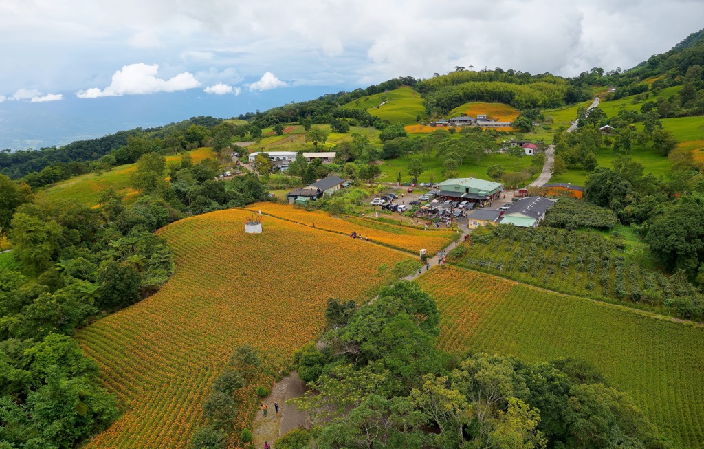
Next, head to the Luye Highlands, the annual Taiwan Hot Air Balloon Festival host. The sky has gliding colorful orbs and cartoon characters. Luye Highlands has an undulating passing of gentle hills with patchwork fields of green. It is a beautiful place to revel in the quiet and peaceful Taitung City.

Situated near Taiwan’s east coast, Yuli Township is wedged between the Huadong Valley (花東縱谷) and the Huadong Coastal Reserve (花東沿海保護區). It has the gentle Hai’an Range (海岸山脈) hills on one side and the Central Mountain Range on the other.
One of the places to survey the Huadong Valley’s fertile landscape is the coastal hill of Liushishishan (六十石山). The best time to climb is in late summer and early autumn when the green rolling fields erupt in a golden carpet of daylilies.
After admiring the grand views of Taiwan’s eastern basin, take in some culture at Wulu Village. Situated at 2,700 meters (8,858 ft), the Bunun tribe makes their home in this misty mountain village. Once you appreciate the flourishing views of undulating hilly meadows and plum blossom groves, you’ll realize why the Bunun live in this secluded and stunning settlement.
Finally, for another piece of beautiful nature, visit the Nanan Waterfall. Feathery ferns and dense shrubbery border the cascading silver rapids. Falling from 50 meters (164 ft), feel the water spritz cool your skin as the frothy foam crashes into the aquamarine pool below.
Take the Taiwan High-Speed Rail (HSR) to Kaohsiung from Taiwan’s major cities to Kaohsiung. Next, board the local express train (TRA) from Kaohsiung to Pingtung City. From here, change platforms and hop on the train at Taitung City. Once in Taitung City, renting a car or scooter to drive 105 km (65 mi) to Sancha Mountain and Xiangyang Moutaing Special Scenic Area is best.