
Scan the QR code and open PeakVisor on your phone
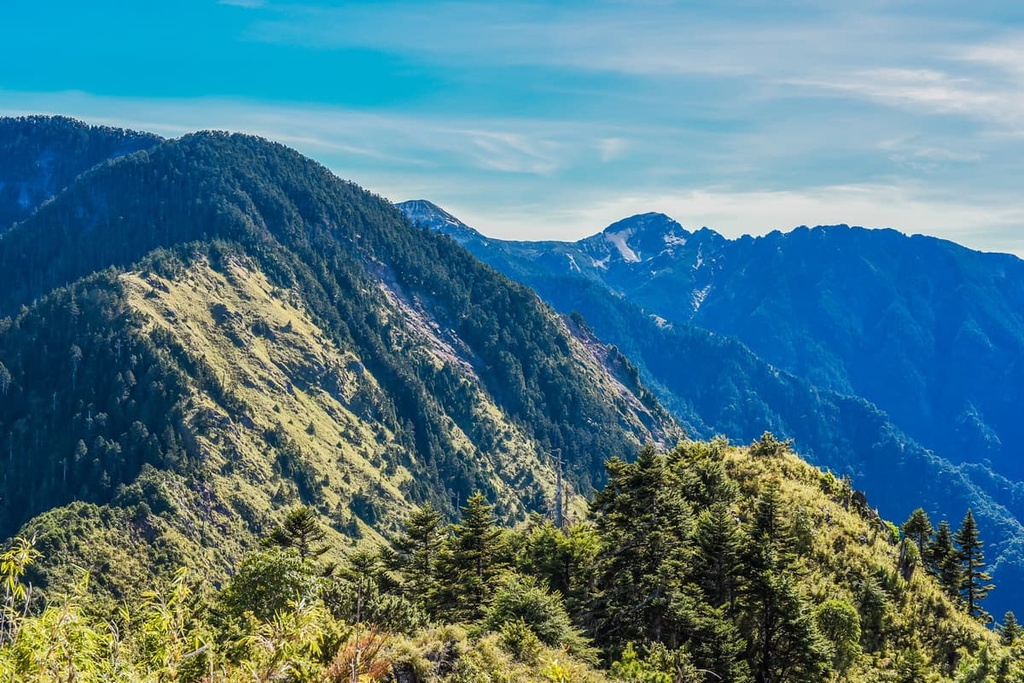
Situated in the region of Guanshan Major Wildlife Habitat (關山野生動物重要棲息環境) and Yushan National Park (玉山國家公園) lies the small mountainous area of Xinkangshan Special Scenic Area (新康山特別景觀區) of eastern Taiwan. Xinkang Shan (新康山), one of Taiwan’s top 100 peaks, is the highest and most prominent of the 2 named mountains in the scenic area at 3,331 metres (10,928 ft). in elevation.
Xinkangshan Special Scenic Area is located in the Zhuoxi Township (卓溪鄉) of Hualien County (花蓮縣) in eastern Taiwan.
The special scenic area contains 2 named peaks. The highest peak is Xinkang Shan. Meanwhile, Xin Xian Shan (新仙山) is the other named mountain in the park, measuring 3,124 metres (10,269 ft). While only two mountains are located in Xinkangshan Special Scenic Area, the area is surrounded by many of Taiwan's 100 highest mountains.
The 100 peaks of Taiwan are also referred to as Baiyue. Xinkang Shan is a Baiyue, and in fact, it’s one of "The Ten Steeps (十峻)" of Taiwan Mountains. The other nearby Baiyue include Sancha Shan (三叉山), Nanshuangtou Shan (南雙頭山), and Bulakesang Shan (布拉克桑山).
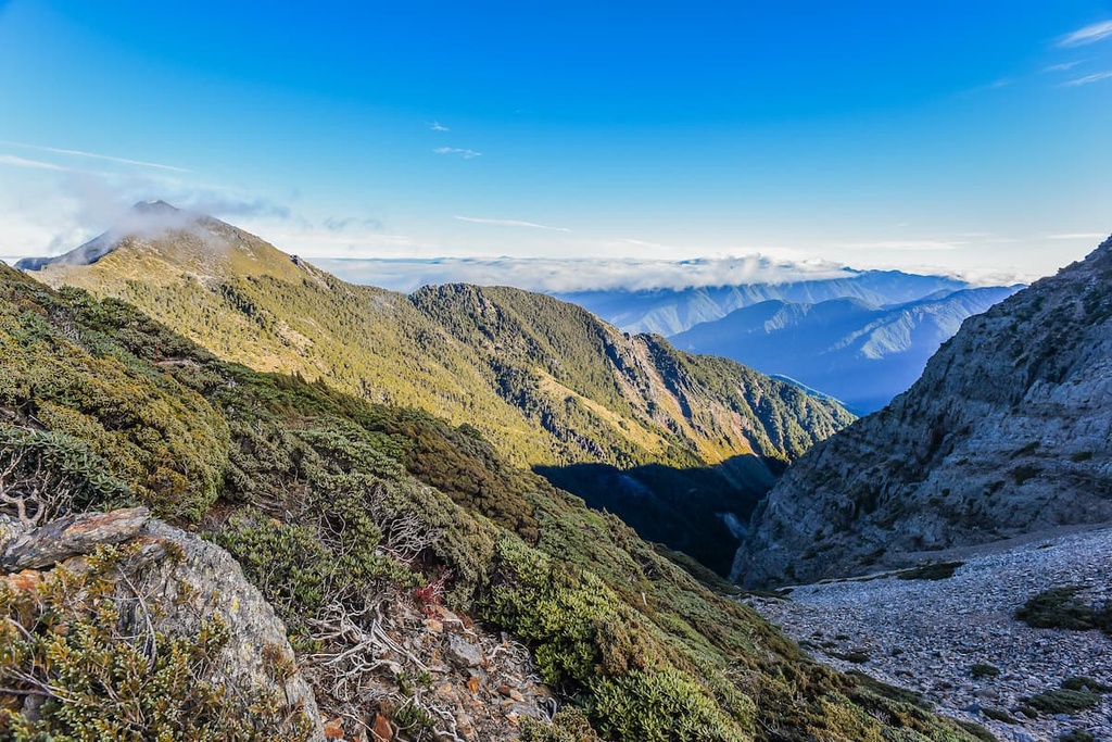
As Xinkang Shan is the easternmost Baiyue in the region, it is unsheltered and therefore unprotected from the often harsh weather conditions that are known to batter the area. As a result, Xinkangshan Special Scenic Area experiences an annual average rainfall figure of 3,000 to 4,700 mm (118 to 185 in).
The Southern Cross-Island Highway runs to the south of the region, avoiding the mountainous zone of Xinkangshan Special Scenic Area. For this reason, the special scenic area is remote and wild, as human access isn't as convenient as it is in areas like the Guanshan Major Wildlife Habitat.
Together with the extreme weather of heavy rain and billowing winds, the area has a refreshingly cool annual average temperature of 46°F (8°C) for elevations over 3,000 metres (9,842 ft). As the elevation decreases to 2,500 metres (8,202 ft), the average temperature rises to 52°F (11°C).
To the north of Xinkangshan Special Scenic Area is the Danda Major Wildlife Habitat (丹大野生動物重要棲息環境). Meanwhile, Shuanggui Lake Major Wildlife Habitat (雙鬼湖野生動物重要棲息環境) is located to the south.
The alpine gem of Jiaming Lake (嘉明湖) is also situated to the west of the scenic area on the southeast slopes of Sancha Shan. Finally, to the east lies the Pacific Ocean.

Xinkang Shan and Xin Xian Shan, the two named mountains of Xinkangshan Special Scenic Area, belong to the Central Mountain Range (中央山脈). Home to more than half of the Baiyue, the 59 peaks of the Central Mountain Range feature as Taiwan’s 100 tallest hills.
The peaks of Xinkangshan Special Scenic Area are composed of metamorphic rocks from the late Paleozoic to the Mesozoic epoch. Greenschist and siliceous schist are the primary rock types in the region.
This eastern area is believed to have once been the seabed before it was uplifted into mountains. Many marine formations are exposed on the rocks in the scenic area, too.
The plant life of the Xinkangshan Special Scenic Area varies based on the elevations in Xinkangshan Special Scenic Area. Various low to medium elevation forests, alpine woodlands, grasslands, and mountain flowers permeate the plant life along the mountain.
Tung trees, camphor trees, and banyan trees appear in the lower broad-leaved forest. Above that, a mix of broad-leaved and coniferous trees stand, with Taiwan white pine and Taiwan cedar adding to the plant life.
The colder temperate trees of Taiwan fir and Yushan juniper fill the sub-alpine region, with fields of undulating Pseudosasa japonica bamboo shielding the mountain path. Finally, Yushan rhododendron, Alishan gentian, and Taiwan lily bloom on the summit of the peaks of Xinkangshan Special Scenic Area.

The main mammals found in the Xinkangshan Special Scenic Area are the Formosan black bear, Formosan rock macaque, and the Taiwan sambar deer. The white eye thrush, red-billed black bulbul, and blue bellied pheasant are common bird species that visit the area, too.
Situated to the north of Xinkangshan Scenic Special Area is the Walami Trail (瓦拉米步道) which forms the eastern part of the Batongguan Yueling Road (八通關越嶺).
During the Japanese Occupation Era, the Japanese created Batongguan Yueling Road for surveillance of the Indigenous Bunun people. The Bunun traditionally lived throughout the mountainous areas of eastern Taiwan. However, they were forced to relocate to the guarded road during the Japanese Occupation Era.
Old police stations are littered along the Batongguan Yueling Road, which connects Yuli to Dashuiku over the course of 82 km (51 mi). In addition, scattered pottery shards and old glass bottles still remain on the mountain road, demonstrating life in the mountains from older times.
Along the Warami Hiking Trail is the memorial to the victims of the Kasipanan Incident, which occurred in the fourth year of Taisho (1915). The Bunun took revenge on the Japanese, who confiscated the Bunan’s guns to cripple their ability to defend themselves. A conflict quickly ensued.
As a result, the Bunun ambushed a Japanese police station one evening, cutting off the telephone wires and setting fire to the building. Out of the ten Japanese police officers that were at the station that evening, no one survived. This event then led to uprisings among other Indigneous tribes in the area, and within one week, they, too, were rebelling against the Japanese.

On the slopes between Sancha Shan and Xinkang Shan, is the site of a US military aircraft wreckage. In 1945, after the Second World War, a US military aircraft carrying released prisoners crashed on the mountain. None of the 26 passengers on board survived the fatal crash. Remnants of the aircraft wreckage are still present on the mountain today.
The major hiking trails and areas in and around the Xinkangshan Special Scenic Area include:
The Xinkangshan Crosswalk Trail climbs four mountains and crosses Taiwan’s second-highest alpine lake, Jiaming Lake. Hikers start the five-day trek at Xiangyang Mountain Pass. The trail is 27 km (17 mi) long and forms a loop.
The first day of the hike involves climbing up the rocky slopes of Xiangyang Shan (向陽山). Sometimes called Hongye Shan (紅葉山), as a name commonly used during the Japanese Occupation Era in Taiwan. Xiangyang Shan is well-known for being steep and difficult to climb; thus, hikers usually require ample breaks to recoup their energy and catch their breath. The climb features sheer cliffs with thin, crumbling rock that can feel unsteady at times.
Hikers soon enter the ethereal world of the well-known white wood forest of Bai Mulin. Here, trees of Taiwan spruce, Taiwan fir, and Yushan juniper were once set on fire. Over 50 years, the bark of these trees has gradually changed to ash white.
While Yushan juniper has bark that’s pale in color, the thick woodlands of stark white trees create a mesmerising scene. It is easy to tell the trees apart as Taiwan fir is the tallest, with Taiwan spruce holding a density of branches. Yushan juniper is unique as its limbs contort and distort, forming knuckles on the parched white bark.
From here, hikers head towards Jiaming Lake Mountain House for an overnight stay. The afternoon clouds announce their delicate presence like clockwork, adding heaps of soft fluffy cotton to the lightening blue afternoon sky.

The following morning, hikers set off towards Sancha Shan after visiting the pristine, alpine Jiaming Lake. Situated at 3,310 metres (10,860 ft), Jiaming Lake ranks only after Taiwan’s Cuei Pond (翠池) in Shei-Pa National Park (雪霸國家公園) in terms of overall size.
Jiaming Lake is renowned for its natural beauty. Indeed, when set against the jade green grasslands on the southeast slope of Sancha Shan, the striking azure-colored lake reflects the radiance of the sunny Taiwanese sky. The brilliant blue lake is ever more visible the higher one climbs. Adding to the scenic showpiece is the presence of Taiwan sambar deer grazing nearby.
Hikers then progress toward Sancha Shan, which displays an endless sea of rippling peaks. Taiwan’s tallest mountain, Yushan (玉山), can be seen in the north alongside Yunfeng Shan (雲峰山) and Xiuguluan Shan (秀姑巒山). Hikers can also view Xinkang Shan in the east with Xiangyang Shan in the west.
As hikers continue the path toward Taoyuan Camp, they pass the wreckage of a military aircraft. Many parts of the aeroplane are scattered about the landscape, a sad reminder of the lives lost in the tragic accident. After spending a night at Taoyuan Camp, hikers continue on toward Lianli Shan (連理山).
The road to Lianli Shan is increasingly steep. When you think you have finally reached the summit, don’t be surprised to learn that you have more to climb. In addition to the steepness of the path itself, the summit of Lianli Shan is overgrown; thus, hikers cannot soak up in the glorious views. Despite the bitter disappointment of no prospects as a reward for the taxing climb, the summit of Xinkang Shan is a 1.7 km (1 mi) journey away.
From the summit of Xinkang Shan, the rock formation of Tiangong Fortress is visible. Straddling above the summit, Tiangong Fortress rises sharply from the alpine forests, from where a narrow block is perched on the solid mound, creating an appearance of a hilly castle.
The views from Xinkangshan are epic, too, as hikers can distinguish the eastern Baiyue of Sancha Shan and Xianyang Shan, with Yushan in the north and Yushan National Park’s S-shaped Southern Second Section’s Baiyue stretching from north to south.
After finally admiring a sweeping vista, hikers head towards Xinxian Mountain Camp for the night. On the way there, they will climb the final peak of the trail, Xin Xian Shan. While not a Baiyue, the views from Xin Xian Shan are still noteworthy, as it displays similar vistas to Xinkangshan. However, the rocky peak of Xinkangshan and its buttress of Tiangong Fortress is easy to see to the east.
Hikers will finish the route at their starting point after retracing the course back to the initial trailhead.

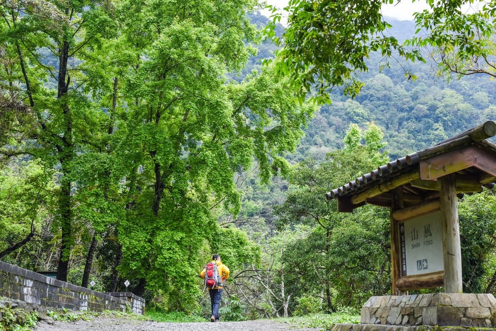
The Walami Hiking Trail is located along the eastern section of the Batongguan Yueling Ancient Road. Measuring a distance of 14 km (8.6 mi), the Walami Hiking Trail follows a gentle path that leads through low to medium elevation broad-leaved forests. The jungle path is shrouded in heavy mist as the rainy, humid climate intensifies the climatic conditions.
Here, hikers can appreciate the natural splendour of this verdant trail in any season. Heartwarming shades of soft pink bloom in late winter and early spring for cherry blossom season, while in autumn, the route is drenched in deep red maple leaves. Summer brings an assortment of exuberant ferns, while the tung tree blossoms in spring.
Starting from the Walami Trail Hiking Entrance just off Highway 30 from Shanfeng, hikers commence the historical road stretching westwards. Shanfeng Waterfall is situated 1.7 km (1 mi) from the trailhead. The Shanfeng Waterfall (山風瀑布) a sharp three-tiered cascade resembles a grand wedding cake. Its gushing waters batter down the three-layered cliffs.
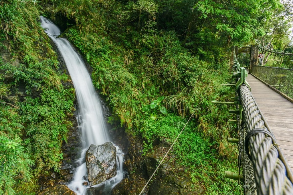
As hikers cross the 30-metre (98 ft) high suspension bridge, the aquatic white sheet of the third and lowest waterfall is most clearly visible. With the highest cliff standing as tall as 720 metres (2,362 ft), Shanfeng Waterfall is a magnificent spectacle of rushing rapids, ferocious water pummelling down the rock walls, and refreshing condensation suspended in the mountain air.
A verdant path of upward rooted ficus trees and fragrant camphor trees leads the way towards Jiashin. Old relics of the Japanese Occupation Era are discovered here, such as a former police station site.
In addition, due to its relatively high elevation, you can see the Lakulaku River Valley in the distance to the southeast. From here, you can also get views of Yuli Shan (玉里山), Zhuoxi Shan (卓溪山) and Huangma Shan (黄麻山).
After 5 km (3 mi) of hiking through a green corridor of luscious ferns, evergreen camphor trees, and moss, the trail leads to the Huangma Valley, where the Lakulaku Riverbank lies nearby. Here, you can also see a memorial to the events of the Kasipanan Incident.
Hikers then proceed toward the Walami Mountain House, the furthest point of the trail. From here, the waters of the Lakulaku River flow beneath the suspension bridge that straddles two cliffs. Hikers then return to the trail's starting point, opting to spend a night at Walami Mountain House should they wish to experience the stillness of nature for an extra day.
A narrow stretch of land known as the East Rift Valley runs from Hualien City (花蓮市) and Taitung City (台東市). It is wedged between the precipitous Central Mountain Range and the gentler coastal mountains. While it extends for 180 km (112 mi), the ridge of Xinkang Shan is situated close to the southern part of the East Rift Valley, also known as Huadong Valley (花東縱谷).
There are many ways to enjoy the East River Valley’s landscape. Huandong Highway runs parallel to the depression. Thus, journeying on the highway is one of the best ways to view the patchwork carpeted plains set against dramatic mountain scenery. Biking is popular in the area, while a train ride presents the untouched terrain right before your eyes.
Layered meadows of rice paddies, neat rows of tea plantations, abundant orchards, and endless fields of lilies are all present in this land of raw and natural beauty.
This narrow, yet long, region passes through the traditional lands of at least four Taiwanese tribes: the Amis, Truku, Pinuyumayan, and Bunun. Thus, visitors can experience at least four distinct tribal cultures and customs during a trip to the area by tasting local delicacies and viewing the region’s traditional farming methods and tribal members’ skilful craftwork.

Situated just off Highway 30, Na’an Waterfall (南安瀑布) is conveniently placed right before the Walami Trail. Many visitors who trek the Walami Trail visit the majestic 50-metre (164 ft) waterfall as a bonus feature to the trail. From the trailhead situated on Highway 30, it is a short one-minute walk to the falls.
In the sweltering summer months, visitors enjoy basking in the refreshing turquoise waters of the falls. In addition, summertime is when the waterfall is most abundant, roaring like a thunderous clap. A collection of ferns and green shrubbery cover the verdant mountain from where the Lele River surges over the cliff’s edge. On sunny days, the combination of water and light creates a rainbow suspended over the gushing falls.
While Xinkangshan Special Scenic Area forms part of Hualien County, Taitung City (台東市) is located much closer to the mountainous region. The sublime ecological wonder of Yuli Township (玉里镇) of Hualien County lies on the doorstep to Xinkangshan Special Scenic Area.
The remote city of Taitung is a delightful surprise for many who undertake the long trip to the less-connected city on Taiwan's east coast.
As the Central Mountain Range dominates the central part of the island, few roads and railway lines lead to the east coast of Taiwan. However, the pristine and untouched landscapes of the lesser-visited Taitung is a secret worth keeping.

Taitung City is the gateway to the luscious escapes of Green Island (綠島) and Orchid Island (蘭嶼). Situated in the inviting waters of the Pacific Ocean, Green Island and Orchid Island serve as paradises for beach lovers and diving enthusiasts. They are also prime spots for surfing, snorkelling, and fishing.
Often featured as the prominent landmark of Taitung, Sanxiantai Bridge is located north of Taitung in Chenggong Township (成功镇). The Sanxiantai Bridge links the coast of Taiwan to the island of Sanxiantai.
Here, the rolling eight arched bridge resembles a dragon's undulating spine as its elongating path extends over the waters of the Pacific Ocean. Visitors can also stroll this 10 km (6 mi) stretch of sandy beach while admiring the unbelievable formation of Sanxiantai Bridge.
The much-loved Zhiben Hot Springs offers a thermal spa experience for visitors on every budget. Well-established resorts feature at the higher end of the scale, with the more affordable hot spring inns on the other end. The heated mineral waters contain sulphur carbonate, which locals believe can help with arthritis and intestinal ailments.
Taitung Forest Park is a Taitung staple. On weekends, many locals and visiting tourists flock to the dark beefwood forests, where numerous trails lead through the 280 ha (692 acre) verdant landscape. Out of the three lakes, Pipa Lake is the most picturesque lake in Taitung Forest Park as the crystal clear waters show the underbelly of the lake.
Meanwhile, nearby Beinan Cultural Park is the most significant prehistoric site in the whole of Taiwan. More than 20,000 artefacts have been unearthed from this Neolithic archaeological site. In addition, 1,600 slate coffins were discovered that date back to between 300 and 1500 BCE.
Rural Yuli is sandwiched between the dramatic Central Mountain Range and the coastal hills. Situated in the heart of the East Rift Valley, Yuli boasts breathtaking landscapes that serve as scenic attractions to visitors.

In the bubbling waters of Antong Creek lies Antong Hot Springs. The hydrogen sulphide waters simmer at temperatures of 60 to 66°C (140 to 151°F). Situated in a valley, visitors relish in the tranquil nature and the light mist clouding above the thermal spring.
Yuli is situated close to the popular Walami Trail. Visitors can enjoy learning about the history of the Japanese Occupation Era while journeying through an enchanted rampant world of opulent ferns and velvety moss.
Liushishishan (六十石山) is the prime place to admire the sunny cloaking of yellow daylilies during the months of August and September. Incredible views of the East Rift Valley and the Pacific Ocean are abundant from the summit of this coastal hill.
The nearest city to Xinkangshan Special Scenic Area is Taitung City. While visitors from northern and eastern cities like Taipei, Taoyuan, Yilan and Hualien can conveniently take local express trains (TRA) to reach Guanshan Station in Taitung City, visitors from the west usually start their journey from Kaohsiung. Visitors should start their journey to Xinkangshan Special Scenic Area from Kaohsiung. If they are in the major cities of Hsinchu, Taichung, Chiayi, and Tainan, they can catch the Taiwan High-Speed Rail (HSR) to Kaohsiung. If they are in the major cities like Hsinchu, Taichung, Chiayi, and Tainan, they can catch the Taiwan High-Speed Rail (HSR) to Kaohsiung.
Visitors shall then take the local express train from Kaohsiung Main Station to Pingtung City. From here, visitors will change platforms to board the eastbound train to Taitung City. Due to the remote location of Taiwan’s east coast, visitors should not rely on public transport to reach the Xinkangshan Special Scenic Area.
It is advised to rent a car or scooter from Taitung City to Xinkangshan Special Scenic Area. It is a 90 km (56 mi) journey to the scenic area.


