
Scan the QR code and open PeakVisor on your phone
Palomar Mountain State Park is a relatively small, yet fun state park located in the southern part of the US state of California that attracts about 70,000 visitors each year. The park contains 2 named mountains, Boucher Hill and Lone Fir Point.
Palomar Mountain State Park is a small, mountainous recreation area located in the southern region of the US state of California. The park is located entirely in San Diego County and it is only about an hour and a half away by car from the city of San Diego, which lies to the southwest.
With only 1,862 acres (753 ha) to its name, Palomar Mountain State Park is one of the smallest of California’s state parks. Furthermore, the park is actually located adjacent to its namesake Palomar Mountain, which is located about 3 miles (5 km) to the northeast in Cleveland National Forest.
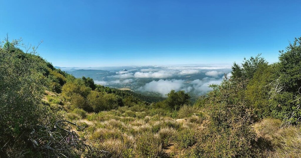
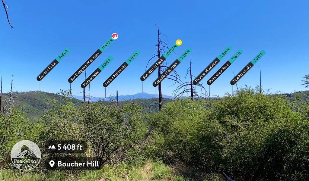
Nevertheless, the park is the perfect place for families, educational groups, and casual hikers as it provides a great entry point to outdoor activities. It provides visitors with phenomenal glimpses of old growth chaparral and woodland forests, as well as expansive vistas of San Diego county. Plus, on a clear day, visitors can even see as far as downtown San Diego from the Boucher Fire Lookout Tower on top of Bouch Hill.
Additionally, Palomar Mountain State Park is situated within driving distance of a number of other fantastic outdoor recreation areas, including Doane Valley Natural Preserve, which is adjacent to the park’s northern border.
Palomar Mountain is also situated just outside Cleveland National Forest, the Agua Tibia Wilderness, the Wilderness Gardens Preserve, and the Hellhole Canyon Open Space Preserve, which lie to the north and south. To the west, Palomar Mountain State Park is just a short distance from the Beauty Mountain Wilderness and the massive Anza-Borrego Desert State Wilderness of Anza-Borrego Desert State Park.

Geologically, the two mountains in Palomar Mountain State Park are part of the Peninsular Ranges of the California Ranges, which extend as far south as the state of Baja California in Mexico and as far north as the city of San Francisco.
Palomar Mountain and the surrounding region are underlain by parts of the Peninsular Ranges Batholith, which formed during the Mesozoic as a result of regional tectonic activity associated with the development of the Elsinore Fault Zone. The mountain itself is actually a large uplifted crustal block on the northeastern side of the fault zone.
Much of the rock composition of the region is dominated by granites and gabbros that date back to the Early Cretaceous. There are also a number of metamorphic rocks in the region, including various schists and gneisses. Finally, the region is known for its plethora of pegmatite intrusions, which are well exposed along East Grade Road.
Each year, Palomar Mountain State Park experiences about 40 inches (102 cm) of rainfall, all of which support the region’s old growth forest and makes the area especially fertile and green in comparison to its neighbors.
As a result, the park is home to a variety of flora and fauna, making hikes particularly dynamic and interesting.There are also a number of educational camps and guides open to visitors and children throughout the year if you’re looking to learn more about the region’s flora and fauna.
Here’s a quick look at the various plants and animals you can expect to see in the park:
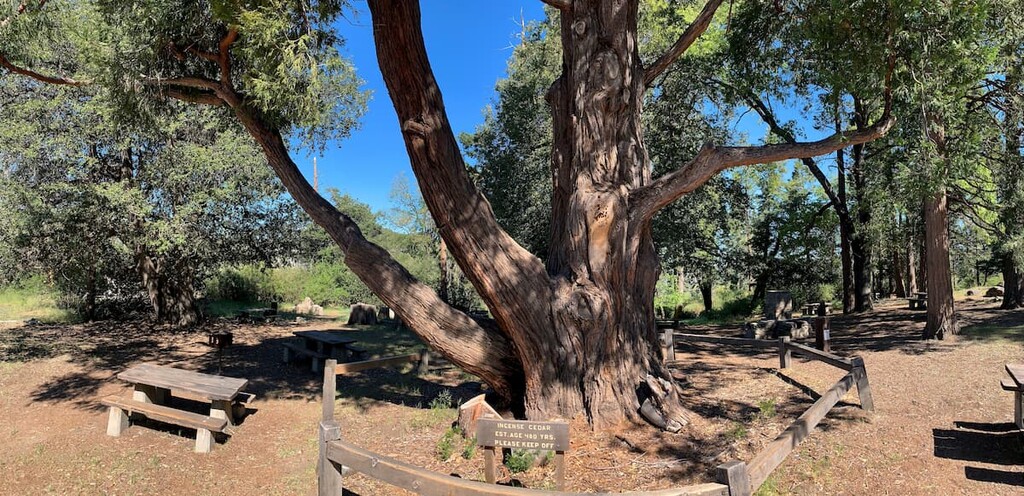
The flora of Palomar Mountain are the main draw for guests to the region. When hiking you can expect to see big cone Douglas fir, white fir, incense cedar (of which there is one over 400 years old living in the park), live oak, black oak, coulter pine, and yellow pine.
Flowering trees and shrubs in the park include the western dogwood, azaleas, juncus grass, goldenrod, lupine, buttercups, penstemons, and wild lilacs (both purple and white).
Visitors to the park can expect to see a variety of wildlife, including southern mule deer, western grey squirrel, raccoons, and striped skunks, as well as predators such as gray foxes, coyotes, bobcats, and maybe even a mountain lion. Additionally, Doane Pond is stocked with trout, and is also home to bluegill, bullhead, and channel catfish.
The history of the park can be felt in the old growth woodlands of Palomar Mountain State Park. Concerted efforts by the state and local environmentalists have worked hard over the years to try to protect the park’s spectacular biodiversity. However, the region in and around the park has a history of human inhabitation that dates back thousands of years, long before the park was ever established.
A number of well-worn bedrock mortars and metates (a flat or slightly hollow oblong stone on which materials such as grain and cocoa are ground using a smaller stone) in the Doane Valley speak to the history of the Luiseño (Payómkawichum) peoples that have long called this region home.
Before the time of European contact, the Payómkawichum people maintained a number of seasonal villages, hunted game, and gathered acorns and other seed crops in this area. There were at least two separate groups of Payómkawichum that were known to have established exclusive territories on the mountain, which they named Wavamai.
Within the park, archaeologists have identified a main village site, as well as ten other temporary camps and gathering stations. The main Payómkawichum village in the region prior to European contact was located at the base of the mountain and was called Pauma.
The area around Boucher Hill, where the Boucher Hill Fire Lookout is now located, was called T’ai and the area around Bailey Lodge was called Paisvi. There are many other Payómkawichum-named areas in the park that have been identified, too, including Chakuli, Malava and Ashachakwo.
The Payómkawichum used the Palomar Mountain area in the summer and early autumn for hunting and gathering acorns, pine seed, elderberries, and grass seeds. Before European contact, the Payómkawichum lived primarily in conical houses made of pine poles covered with bark that they called “wikiups” or “kecha kechumat.”
The Payómkawichum also made semi-subterranean “sweat-houses” that were centrally located in the village and used for purification or curing rituals. Furthermore, the Payómkawichum also made a number of utilitarian objects by hand including clay jars, woven baskets, throwing sticks, nets for fishing or carrying, bows and arrows, and a variety of utensils for cooking and eating.
However, many of the Payómkawichum were forced off their ancestral homelands and forced into servitude at Spanish missions in the Temecula Valley by the end of the eighteenth century. Many thousands of Payómkawichum died as a result of poor nutrition, violence, and introduced diseases during this period.
These days, there are seven bands of Payómkawichum (Luiseño) that live in and around the region of Palomar Mountain State Park, including:
When the Spanish came to the area they named the mountain Palomar, meaning “place of the pigeons,” which was a reference to the thousands of band tailed pigeons that nested in the area.
In 1798, Mission San Luis Rey was established just 4 miles (6 km) upstream from the mouth of the San Luis Rey River. The pines and firs from Palomar Mountain were used in the construction of the mission.

An additional outpost in Pala, California to the west of Palomar Mountain, was established in 1816 and Father Antonio Peyri, a Fransiscan missionary at the Mission from 1798 to 1832 often worked with tribal communities in the area several weeks each year.
While the mission and Father Antonio were initially fairly well received by the Payómkawichum, the mission had far reaching negative effects. The interruption of traditional ways of life, as well as the introduction of diseases to Indigenous communities led to the destruction of the Payómkawichum community. The mission closed in 1834 with the order by Governor Figueroa to secularize California.
Palomar Mountain State Park was created in the 1930s after the state acquired what they called “the most attractive part of the mountain.’ San Diego County and local community groups also chipped in to match funds to purchase the land and create the Palomar Park Association.
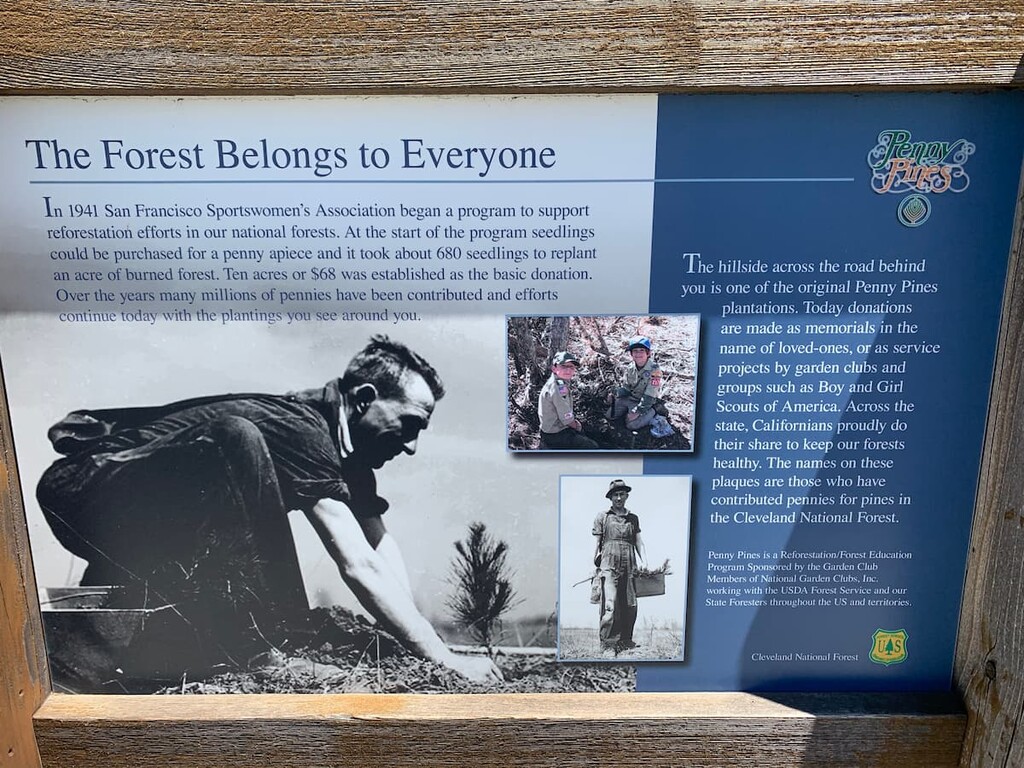
Most of the roads, campsites, and trails that visitors use today were built by the Civilian Conservation Corps in the 1930s and there is a plaque near the summit of Boucher Hill in honor of their work.
The construction of the 200-inch (199 cm) Hale Telescope at Palomar observatory took place during the Great Depression and World War II. In 1934, the Hale Telescope was to be the largest in the world, so construction was in full swing during this time in order to build the observatory’s various pieces.
However, it was not until 1947 that the mirror for the telescope even arrived, and not until 1949 that the telescope opened its eyes to the cosmos. Palomar Mountain was designated the perfect place for the telescope at the time because of its height and regional darkness at night as a result of the surrounding Cleveland National Forest, which keeps out large-scale development.

Though by no means the largest or highest definition telescope anymore, the Palomar Observatory is still active. Plus, the observatory even welcomes guests every day of the year except Christmas Eve and Christmas.
Like many state parks in California, there are a number of things visitors need to be aware of as they hike through the area.
Rattlesnakes are routinely found on the hiking trails in Palomar Mountain State Park and they are an important part of the region’s ecosystems. It is important to be aware of where you are stepping and if you hear the rattle of a snake, stop and locate the snake before moving away. These creatures are not interested in interacting with humans and will not bite unless provoked.
Ticks are another critter to be very aware of while at Palomar Mountain state park. The region’s brushy environment is a great habitat for ticks, so be sure to do a tick check after your hikes, stay on established trails, and avoid moving needlessly through thick brush. Lyme disease is the biggest risk associated with ticks in the US; luckily, however, southern California’s instance of Lyme disease is very low.
Poison oak is also a resident of the park. Visitors need to remember the old saying, ‘Leaves of three, let them be.’
Hikers should also keep an eye out for ants on the trail. The large red fire ants in the park have a bite that is painful and leaves a welt, so stay on the trail and keep an eye out. Keeping a smart watch out for these things will result in a much happier trip overall.
Finally, mountain lions, which are also known as cougars and pumas, are a resident of the region and hikers need to take reasonable precautions to avoid an unpleasant encounter. Luckily, these animals are very shy and do not want to interact with humans.
However, there are a few things we can do to avoid coming across their path. Just like with bears it is important to always try to hike with a partner and make a fair amount of noise as you move, that way you will not surprise a mountain lion if you come across their path. It is also important to try not to hike during dawn or dusk as that is when mountain lions are at their most active.
IIf you do come across a mountain lion there are a few key things to remember. In particular, try to make yourself look big. If you have a child, pick them up so that you both look bigger. Make a lot of noise and move your arms around, but do not run! Also do not crouch down or turn your back on the mountain lion leste you trigger its predatory response.

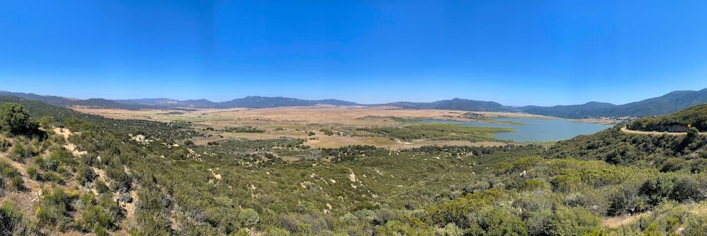
There are two main hiking areas in Palomar Mountain State Park: the more southerly area that encompasses both Thunder Springs and Boucher Hill, and the Doane Valley Nature Preserve. Visitors can hike as little as half a mile (800 m) or as much as 10 miles (16 km) depending on how much of the park they want to explore.
One solid loop of Palomar Mountain State Park is Boucher Hill via Thunder Springs. This loop is 6.3 miles (10.1 km) long with 1630 feet (497 m) of elevation gain and descent.
To start this hike, you’ll begin at the trailhead to Doane Pond and head southeast on the trail towards Thunder Springs. You will soon head into the old growth forest before heading up to Chimney Flats.
Once you climb over the ridgeline you will pass by a historic apple orchard on the Scott’s Cabin Trail. Turn left at the Scott’s Trail Spur towards the park headquarters and entrance. When you get to the entrance take a break to enjoy the view and check out the 400 year old incense cedar in the picnic area.
Then, take the road for 400 yards until you come up on the Civilian Conservation Corps memorial stone. You will then take the Boucher Trail up Boucher Hill. At the end of this trail, you will get a great view of the surrounding Cleveland National Forest and can check out the Boucher Hill Fire Lookout.
To head back down and back towards Doane Pond take the Adams Trail until you hit the Cedar Grove Group Campground. Walk past the campground and hop on the Scott’s Cabin Trail for a short time before turning left on the Cedar Trail which puts you back where you started on Doane Pond.
A shorter option for people looking for a quick adventure, the Doane Valley Nature Preserve Trail is around 2 miles (3 km) long.
For this hike, you’ll take the Doane Valley Trail from Doane Pond and connect to the French Valley Trail near the Doane Valley Campground. You will continue along this trail until it meets up with the Doane Valley Trail again and connects to the Lower Doane Valley Trail before heading back to the main Doane Valley Nature Trail and back to the Pond.
Visitors to Palomar Mountain State Park have the option to either camp in a number of developed campsites, or stay in the nearby town of Julian, which is a popular tourist destination in the area.
Additionally, Palomar Mountain State Park is a relatively short drive away from some of the other major cities in the region. Here are some of the best places to check out during your stay:

There are two main options for camping in Palomar Mountain State Park: Doane Valley campground and Cedar Grove Group Campground.
The Doane Valley Campground is located in the heart of the park next to Doane Pond in the aptly named Doane Valley. This campground is often full with families and educational groups during the open season, so be sure to book your campsites early to avoid disappointment.
Doane Valley is also home to the Camp Palomar Outdoor School for 6th grade students in the San Diego Unified School District. The park also contains the Cedar Grove Group Campground to the west of Doane Valley.
Additionally, the Oak Knoll Campground is also an option for visitors to the park. It is conveniently set off California State Highway 76, about six miles from the amazing Palomar Mountain Observatory.
The Oak Knoll Campground was formerly known as Palomar Gardens as was made famous in the 1950s and 1960s, by its owner and resident, UFO contactee George Adamski (author of Flying Saucers Have Landed). Adamski had a self-built, wooden observatory at Palomar Gardens and photographed objects in the night sky that he claimed were UFOs.
In 1977, the film The Crater Lake Monster even filmed a number of scenes on Palomar Mountain, including a number of scenes that were shot at the summit restaurant.
Los Angeles is about two and a half to three hours away from Palomar Mountain State Park, depending on traffic. But, it is an easy drive mostly down Interstate 15 before you turn off at Temecula and take country highways for the rest of the trip. While you could swing a day trip here from LA, the city is better as a stop over one your way further south.

San Diego is about an hour and a half away from Palomar Mountain State Park. Therefore, it’s easy enough to make a trip to the park and back in just one day from San Diego. The route from San Diego is fairly straightforward, too, as it follows Interstate 15 until you reach Escondido and continue on country highways until you reach the park.

If you want to explore Palomar Mountain State Park, but you want some of the comforts of home, Julian is your best bet. This small gold mining–turned tourist town is a major byway for Pacific Crest Trail hikers and has tens of restaurants, breweries, cider mills, wineries, antique and craft markets, bed and breakfasts, and hotels to keep you comfortable and entertained.


