
Scan the QR code and open PeakVisor on your phone
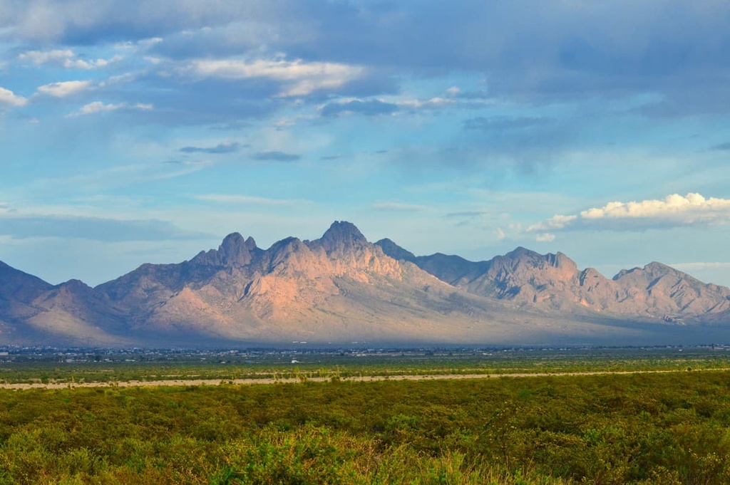
The Organ Needles Wilderness Study Area is located in the southern region of the US state of New Mexico. Situated along the ridgeline of the Organ Mountains, the wilderness study area contains 35 named peaks. The highest and most prominent mountain in the range is The Needle, which is 8,976 ft (2,736 m) tall and has 3,734 ft (1,138 m) of prominence.
The Organ Needles Wilderness Study Area lies in the south-central portion of the US state of New Mexico. The wilderness study area is located within the Organ Mountains-Desert Peaks National Monument, which is situated just to the east of the Rio Grande.
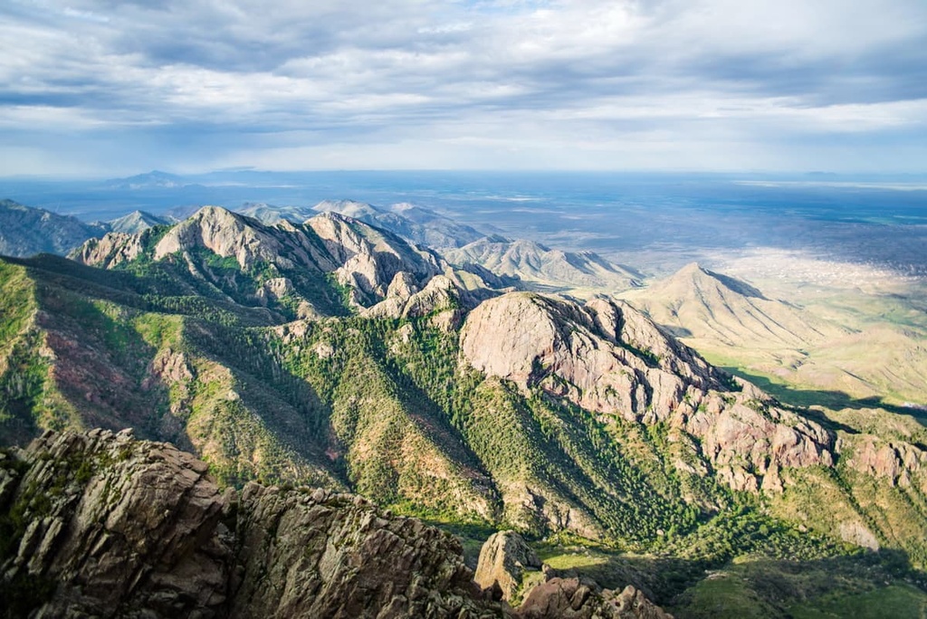
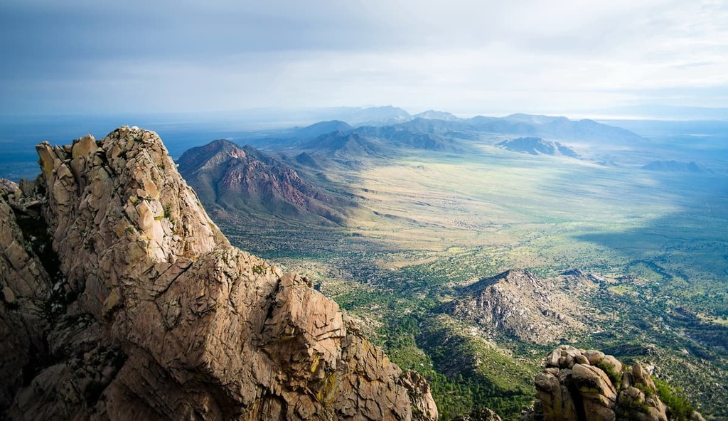
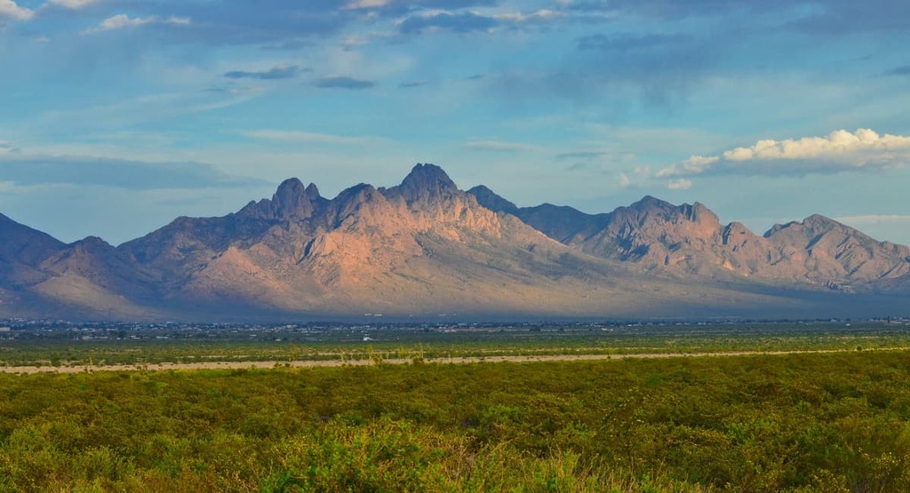
The rugged landscape in the wilderness study area is defined by the Organ Mountains, which run in a north to south direction within the national monument. The wilderness study area encompasses 7,604 acres (3,077 ha) of land primarily on the western slopes of the mountain range
The ridgelines in the wilderness study area consist of jagged spires along with steep and narrow canyons. Elevation changes are drastic in the region as rolling fields lie directly to the west and east of the range. The Mesilla Valley and Tularosa Basin are located on either side of the Organ Mountains.
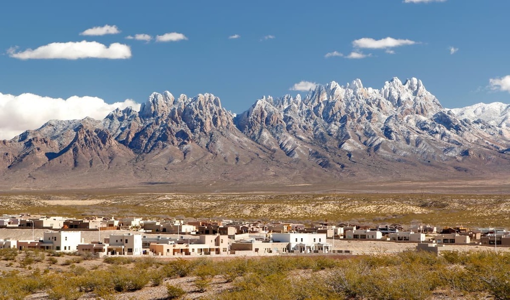
The solid granite formations of the Organ Mountains tower above the gentle landscape that’s located down below. Meanwhile, the southern stretches of the wilderness study area primarily contain rhyolite along with granite. The city of Las Cruces lies just 10 miles (16 km) to the west of the wilderness study area.
Additionally, the Organ Needles Wilderness Study Area is situated near various other areas for outdoor recreation.
The wilderness study area is surrounded by the Organ Mountains-Desert Peaks National Monument. Other protected areas that are located nearby include the Peña Blanca Wilderness Study Area, Organ Mountains Wilderness, Mesilla Valley Bosque State Park, Aden Lava Flow Wilderness, and San Andres National Wildlife Refuge.
The Organ Mountains are part of a long line of mountain ranges that are situated along the east side of the rift valley of the Rio Grande. Though the San Andres Mountains and Franklin Mountains lie just to the north and south of the range, the Organ Mountains are geologically very different from their rugged neighbors.
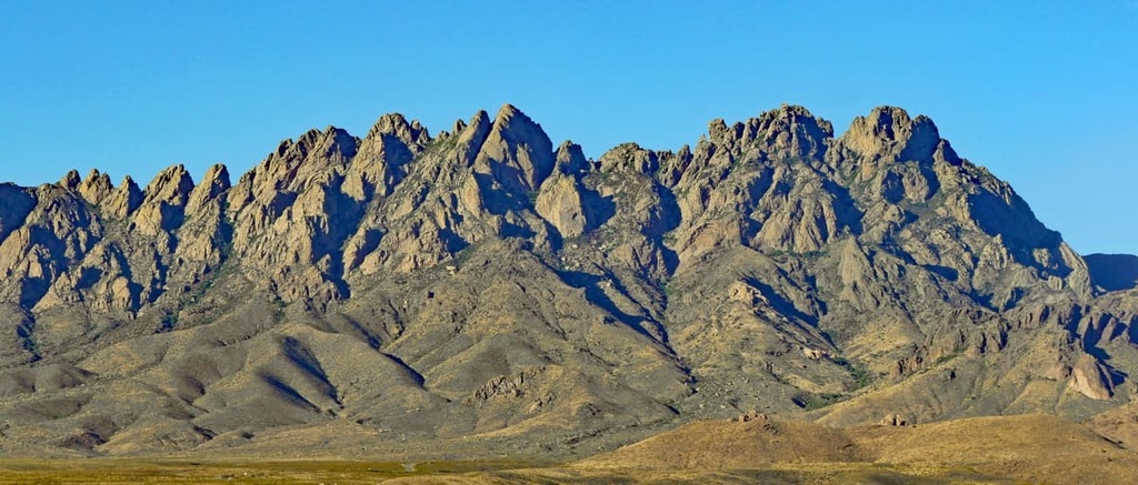
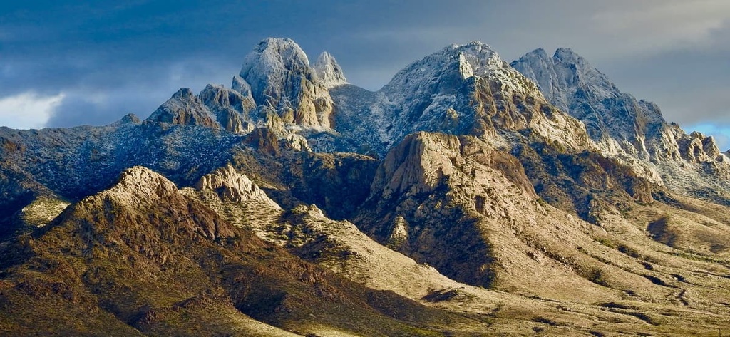
The Organ Mountains consist primarily of igneous rock, including granite and rhyolite. The tall spires that define the range are composed of granite, and they loosely resemble the tall pipes on an organ.
Geologically, the Organ Mountains consist of three major sections. The northern stretches of the range feature a narrow ridgeline of Tertiary granite. This portion is often referred to as “The Needles” due to its dramatic features.
The southern portion of the range features extrusive igneous rock. Here the rhyolite has an almost purple appearance. The southwestern and southeastern sides of the Organ Mountains boast lower elevations and fault-block limestone formations, making them more similar to the surrounding ranges.
Much of the landscape visible today in the Organ Mountains was formed nearly 36 million years ago during the Eocene epoch. Magma eruptions from the Organ caldera volcano took place during this time, dispersing lava, rock, and ash across the surrounding landscape in the process.
Major peaks within the district include The Needle, Organ Needle, Rabbit Ears, The Wedge, Rabbit Ears Massif, and Little Square Top.
There is a diversity of flora and fauna in the Organ Needles Wilderness Study Area. In fact, the wilderness study area is home to five endemic plant species.
The foothills of the range consist of forested areas that contain gray oak, mountain mahogany, sotol, alligator juniper, and piñon pine. Both desert shrubs and grasses are common throughout the wilderness study area. As elevations increase, the forested landscape in the region begins to transform into stands of ponderosa pine.
Seasonal creeks and streams provide further irrigation for the plant and animal life in the Organ Mountains. There are even four endemic species of mollusks found in the region’s waterways.
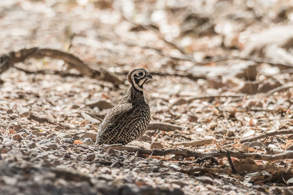
Larger mammals in the region include mule deer and mountain lions. Common bird species include the Montezuma quail, red-tailed hawks, golden eagle, and the endangered Aplomadon falcon. The birds of prey in the region primarily feed on rock squirrels, mice, and small rodents.
The land in and surrounding the Organ Needles Wilderness Study Area has a long and rich human history that dates back long before the arrival of European settlers.
Archaeological sites and prehistoric rock shelters have been found throughout the wilderness study area and surrounding mountain ranges. Many of these cultural artifacts date back to between 8,000 and 12,000 years ago.
This region is part of the ancestral homelands of the Mescalero Apache (Naa'dahéõdé) and Piro Pueblo tribes. Members of these tribes were forced away from their ancestral homelands as settler populations began to increase throughout the Rio Grande Valley.
The first non-Indigenous people to travel through the region were Spanish conquistadors and colonizers. These groups of people disregarded the Indigenous names for the region and instead called the Organ Mountains the Sierra de los Órganos due to their organ-like appearance.
The region around what is now called the Organ Mountains was commonly fought over by the US, Spain, Mexico, and the Apache tribes throughout the 1800s. Nearby mountain ranges were part of ongoing territorial disputes in the nineteenth and twentieth centuries as a result of the Mexican American War and the Apache Wars. Remnants of these battles can be seen in a famous hideout used by Geronimo, a great Apache warrior.
The Baylor Trail that traverses the Organ Mountains was originally established in the 1860s during the US Civil War. During this time, settlers continually attacked, displaced, and murdered the Indigenous people of the region in order to stake a claim to the land.
The surrounding Organ Mountains-Desert Peaks National Monument was established in 2014. Nowadays, the Mescalero Apache Tribe has a reservation that’s located to the northeast of the wilderness study area, just outside of the Lincoln National Forest.
The Organ Needles Wilderness Study Area is home to relatively few hiking opportunities on maintained trails. That said, here are some of the best hikes in the wilderness study area to check out during your next adventure in the region.
The Pine Tree Trail lies along the southern edge of the Organ Needles Wilderness Study Area. This loop trail showcases the different landscapes throughout the region. Hikers on this trail can enjoy views of the surrounding Organ Mountains while sweeping fields extend to the east.
This route features forested sections, panoramic views, and numerous seasonal creeks. Hikers should be aware of rattlesnakes as they hike since these snakes may attack if provoked. This loop trail is 4.6 miles (7.4 km) long round-trip and it has 1,135 feet (346 m) of elevation gain.
The trail to the summit of Baylor Peak begins on the eastern side of the Organ Mountains. The beginning of this trail climbs steadily through the shrub, grass, and boulder-filled landscape. After about two miles, the route climbs steeply up to the summit of Baylor Peak.
From the summit, hikers are rewarded with panoramic views of the surrounding landscape and nearby granite spires. This out-and-back route is 5.5 miles (8.9 km) long and it has 2,093 feet (638 m) of elevation gain.
The Organ Needles Trail is a challenging and steep hike in the wilderness study area. The trail begins along the western edge of the Organ Mountains. The main route on this trail requires both bushwhacking and scrambling, so hikers should be prepared for a wide range of different adventures during this hike.
Once hikers reach Juniper Saddle, the trail continues up Dark Canyon before eventually reaching the summit of Organ Needle. The rugged ridgeline around the Organ Needle features minimal amounts of flora, allowing for stunning views throughout the route. This trail is 5.8 miles (9.3 km) long and it has 3,579 feet (1,091 m) of elevation gain.
The Baylor Pass National Recreation Trail is the only designated trail that traverses the Organ Mountains in an east-to-west fashion. The route can be completed as a point-to-point or out-and-back hike. For this hike, the starting and ending points are located at Baylor Canyon Road and Aguirre Springs Campground.
This trail offers hikers stunning views of the northern Organ Mountains while rugged rock formations tower above. If completed as an out-and-back hike, this trail is 11.3 miles (18 km) in length and it has 2,404 feet (733 m) of elevation gain.
Looking for a place to stay near the Organ Needles Wilderness Study Area? Here are some of the best cities and villages to check out in the region:
Las Cruces lies just 10 miles (16 km) to the west of the wilderness study area, making it the closest city to the Organ Needles. With a population of around 111,000 residents, Las Cruces is the largest city in southern New Mexico.
The city of Las Cruces serves as both a cultural and economic center for much of the Mesilla Valley. Annual celebrations in the region include the Harvest Wine Festival, Southern New Mexico Wine Festival, and an annual Day of the Dead celebration.
The culture of the city is heavily influenced by its close proximity to Mexico. Various portions of the Organ Mountains–Desert Peaks National Monument surround the city. Visitors looking to learn more about the region while in Las Cruces can visit the Branigan Cultural Center, Gadsden Museum, and Las Cruces Museum of Art.
Located less than an hour’s drive to the south of Las Cruces is the city of El Paso, Texas. The city is situated near the shared borders of New Mexico, Texas, and Mexico. Home to around 678,000 residents, El Paso is the sixth-largest community in the state. El Paso is also nestled along the Rio Grande, just across the border from the Mexican city of Ciudad Juárez.
Popular museums to visit in El Paso include the Centennial Museum and Chihuahuan Desert Gardens, El Paso Museum of Archaeology, and El Paso Museum of Art. Those looking for outdoor recreation opportunities in the city can explore the nearby Franklin Mountains State Park and Hueco Tanks State Park. The Hispanic culture of El Paso is also showcased through the city’s architecture, local shops, art galleries, and restaurants.


